 Discussion Discussion
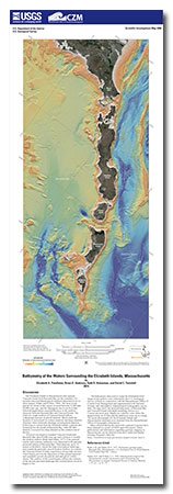
The Elizabeth Islands in Massachusetts that separate Vineyard Sound from Buzzards Bay are the remnants of a moraine (unconsolidated glacial sediment deposited at an ice sheet margin; Oldale and O’Hara, 1984). The most recent glacial ice retreat in this region occurred between 25,000 and 20,000 years ago, and the subsequent rise in sea level that followed deglaciation caused differences in the seafloor character between Buzzards Bay and Vineyard Sound. The relatively rough seafloor of Vineyard Sound reflects widespread exposure of glacial material. Shoals mark the location of recessional ice contact material, and deep channels illustrate where meltwater drainage incised glacial deposits. Following ice retreat from the Elizabeth Islands, a glacial lake formed across the mouth of Buzzards Bay, when the lake drained, it scoured two deep channels at the southern end of the bay.
Sea level rise began to inundate Vineyard Sound and Buzzards Bay about 8,000 years ago and continues to modify the modern seafloor (Robb and Oldale, 1977). Fine-grained marine and estuarine sediments were deposited in the partially protected setting of Buzzards Bay. These deposits, up to 10 meters in thickness, buried the high-relief glacial landscape and created the generally smooth modern seafloor. In contrast, the Vineyard Sound of today experiences strong tidal currents, which largely prevent the deposition of fine-grained material and constantly rework the glacial sand and gravel within shoals. The seafloor of the sound largely reflects the contours of the ancient glaciated landscape that existed before sea level began to rise.
The bathymetric data used to create the hillshaded relief image of the seafloor were collected by the U.S. Geological Survey (USGS) in cooperation with the Massachusetts Office of Coastal Zone Management and supplemented with National Oceanic and Atmospheric Administration hydrographic survey data. The map shows the detailed bathymetry of Buzzards Bay and Vineyard Sound with depth soundings shown on a 5-meter-per-pixel grid. Depths are coded by color where the deepest areas are in blue and the shallowest areas are in orange. The aerial photography for the Elizabeth Islands and Massachusetts mainland were obtained from the Massachusetts Office of Geographic Information.
Data collected during this statewide cooperative project have been released in a series of USGS open-file reports. These publications and information regarding geologic mapping in Massachusetts can be obtained from the Coastal and Marine Geology Program’s Web site (http://woodshole.er.usgs.gov/project-pages/coastal_mass/).
|
First posted April 24, 2014
Part or all of this report is presented in Portable Document Format (PDF). For best results viewing and printing PDF documents, it is recommended that you download the documents to your computer and open them with Adobe Reader. PDF documents opened from your browser may not display or print as intended. Download the latest version of Adobe Reader, free of charge.
|

