Skip Links

USGS - science for a changing world

Scientific Investigations Map 3287

Geologic and Geophysical Maps of the Eastern Three-Fourths of the Cambria 30´ x 60´ Quadrangle, Central California Coast Ranges

By R.W.Graymer, V.E. Langenheim, M.A. Roberts, and Kristin McDougall

Thumbnail of and link to report PDF (48 MB)Summary

The Cambria 30´ x 60´ quadrangle comprises southwestern Monterey County and northwestern San Luis Obispo County. The land area includes rugged mountains of the Santa Lucia Range extending from the northwest to the southeast part of the map; the southern part of the Big Sur coast in the northwest; broad marine terraces along the southwest coast; and broadvalleys, rolling hills, and modest mountains in the northeast.

This report contains geologic, gravity anomaly, and aeromagnetic anomaly maps of the eastern three-fourths of the 1:100,000-scale Cambria quadrangle and the associated geologic and geophysical databases (ArcMap databases), as well as complete descriptions of the geologic map units and the structural relations in the mapped area. A cross section is based on both the geologic map and potential-field geophysical data.

The maps are presented as an interactive, multilayer PDF, rather than more traditional pre-formatted map-sheet PDFs. Various geologic, geophysical, paleontological, and base map elements are placed on separate layers, which allows the user to combine elements interactively to create map views beyond the traditional map sheets. Four traditional map sheets (geologic map, gravity map, aeromagnetic map, paleontological locality map) are easily compiled by choosing the associated data layers or by choosing the desired map under Bookmarks.

First posted February 25, 2014

For additional information, contact:
Contact Information, Geology, Minerals, Energy, & Geophysics Science Center—Menlo Park, California
U.S. Geological Survey
345 Middlefield Road
Menlo Park, CA 94025-3591
http://geomaps.wr.usgs.gov/

Part or all of this report is presented in Portable Document Format (PDF). For best results viewing and printing PDF documents, it is recommended that you download the documents to your computer and open them with Adobe Reader. PDF documents opened from your browser may not display or print as intended. Download the latest version of Adobe Reader, free of charge.


Suggested citation:

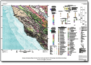
Graymer, R.W., Langenheim, V.E., Roberts, M.A., and McDougall, Kristin, 2014, Geologic and geophysical maps of the eastern three-fourths of the Cambria 30' x 60' quadrangle, central California Coast Ranges: U.S. Geological Survey Scientific Investigations Map 3287, map sheets 1:100,000 scale (interactive pdf), pamphlet 50 p., https://dx.doi.org/10.3133/sim3287.

ISSN 2329-132X (online)


Accessibility FOIA Privacy Policies and Notices

Take Pride in America logo USA.gov logo U.S. Department of the Interior | U.S. Geological Survey
URL: http://pubsdata.usgs.gov/pubs/sim/3287/index.html
Page Contact Information: GS Pubs Web Contact
Page Last Modified: Thursday, 01-Dec-2016 17:31:31 EST