 Abstract Abstract
Historically, the water-supply requirements of the Albuquerque metropolitan area of central New Mexico were met almost exclusively by groundwater withdrawal from the Santa Fe Group aquifer system. In response to water-level declines, the Albuquerque Bernalillo County Water Utility Authority (ABCWUA) began diverting water from the San Juan-Chama Drinking Water Project in December 2008 to reduce the use of groundwater to meet municipal demand. Modifications in the demand for water and the source of the supply of water for the Albuquerque metropolitan area have resulted in a variable response in the potentiometric surface of the production zone (the interval of the aquifer, from within about 200 feet below the water table to 900 feet or more, in which supply wells generally are screened) of the Santa Fe Group aquifer system. Analysis of the magnitude and spatial distribution of water-level change can help improve the understanding of how the groundwater system responds to withdrawals and variations in the management of the water supply and can support water-management agencies’ efforts to minimize future water-level declines and improve sustainability. The U.S. Geological Survey (USGS), in cooperation with the ABCWUA, has developed an estimate of the 2012 potentiometric surface of the production zone of the Santa Fe Group aquifer system in the Albuquerque metropolitan area. This potentiometric surface is the latest in a series of reports depicting the potentiometric surface of the area.
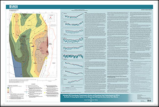
This report presents the estimated potentiometric surface during winter (from December to March) of water year 2012 and the estimated changes in potentiometric surface between predevelopment (pre-1961) and water year 2012 for the production zone of the Santa Fe Group aquifer system in the Albuquerque metropolitan area. Hydrographs from selected piezometers are included to provide details of historical water-level changes.
In general, water-level measurements used for this report were collected in small-diameter observation wells screened over short intervals near the middle of the production zone and were considered to best represent the potentiometric head in the production zone. The water-level measurements were collected by various local and Federal agencies. The water year 2012 potentiometric surface map was created in a geographic information system, and the change in water-level altitude from predevelopment to water year 2012 was calculated. The 2012 potentiometric surface indicates that the general direction of groundwater flow is from the Rio Grande towards clusters of supply wells in the east, north, and west. Water-level changes from predevelopment to 2012 were variable across the Albuquerque metropolitan area. Estimated drawdown from 2008 was spatially variable across the Albuquerque metropolitan area. Hydrographs from piezometers on the east side of the river indicate an increase in the annual highest water-level measurement from 2008 to 2012. Hydrographs from piezometers in the northwest part of the study area indicate either steady decline of the water-level altitude over the period of record or recently variable trends in which water-level altitudes increased for a number of years but have declined since water year 2012.
|
First posted July 16, 2014
Part or all of this report is presented in Portable Document Format (PDF). For best results viewing and printing PDF documents, it is recommended that you download the documents to your computer and open them with Adobe Reader. PDF documents opened from your browser may not display or print as intended. Download the latest version of Adobe Reader, free of charge. More information about viewing, downloading, and printing report files can be found here.
|

