 Abstract
Shoreline erosion rates along Lake Sharpe, a Missouri River reservoir, near the community of Lower Brule, South Dakota, were studied previously during 2011–12 by the U.S. Geological Survey, the Lower Brule Sioux Tribe, and Oglala Lakota College. The rapid shoreline retreat has caused many detrimental effects along the shoreline of Lake Sharpe, including losses of cultural sites, recreation access points, wildlife habitat, irrigated cropland, and landmass. The Lower Brule Sioux Tribe is considering options to reduce or stop erosion. One such option for consideration is the placement of discontinuous rock breakwater structures in shallow water to reduce wave action at shore. Information on the depth of water and stability characteristics of bottom material in nearshore areas of Lake Sharpe is needed by the Lower Brule Sioux Tribe to develop structural mitigation alternatives. To help address this need, a bathymetric survey of nearshore areas of Lake Sharpe near Lower Brule, South Dakota, was completed in 2013 by the U.S. Geological Survey in cooperation with the Lower Brule Sioux Tribe.
HYPACK® hydrographic survey software was used to plan data collection transects for a 7-mile reach of Lake Sharpe shoreline near Lower Brule, South Dakota. Regular data collection transects and oblique transects were planned to allow for quality-assurance/quality-control comparisons.
Two methods of data collection were used in the bathymetric survey: (1) measurement from a boat using bathymetric instrumentation where water was more than 2 feet deep, and (2) wading using Real-Time Kinematic Global Navigation Satellite System equipment on shore and where water was shallower than 2 feet deep. A dual frequency, 24- or 200-kilohertz narrow beam, depth transducer was used in conjunction with a Teledyne Odom CV100 dual frequency echosounder for boat-based data collection. In water too shallow for boat navigation, the elevation and nature of the reservoir bottom were mapped using Real-Time Kinematic Global Navigation Satellite System equipment.
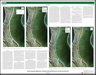
Once the data collection effort was completed, data editing was performed in HYPACK® to remove erroneous data points and to apply water-surface elevations. Maps were developed separately for water depth and bottom elevation for the study area. Lines of equal water depth for 2, 3, 3.5, 4, and 5 feet from the water surface to the lake bottom were mapped in nearshore areas of Lake Sharpe. Overall, water depths stay shallow for quite a distance from shore. In the 288 transects that crossed a 2 foot depth line, this depth occurred an average of 88 feet from shore. Similarly, in the 317 transects that crossed a 3 foot depth line, this did not occur until an average of 343 feet from shore. Elevation contours of the lake bottom were mapped primarily for elevations ranging from 1,419 to 1,416 feet above North American Vertical Datum of 1988.
Horizontal errors of the Real-Time Kinematic Global Navigation Satellite System equipment for the study area are essentially inconsequential because water depth and bottom elevation were determined to change relatively slowly. The estimated vertical error associated with the Real-Time Kinematic Global Navigation Satellite System equipment for the study area ranges from 0.6 to 0.9 inch. This vertical error is small relative to the accuracy of the bathymetric data.
Accuracy assessments of the data collected for this study were computed according to the National Standard for Spatial Data Accuracy. The maps showing the lines of equal water depth and elevation contours of the lake bottom are able to support a 1-foot contour interval at National Standards for Spatial Data Accuracy vertical accuracy standards, which require a vertical root mean squared error of 0.30 foot or better and a fundamental vertical accuracy calculated at the 95-percent confidence level of 0.60 foot or better.

