Scientific Investigations Map 3316
|
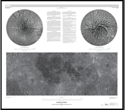
Map DescriptionsSheet 1: This image mosaic is based on data from the Lunar Reconnaissance Orbiter Wide Angle Camera (WAC; Robinson and others, 2010), an instrument on the National Aeronautics and Space Administration (NASA) Lunar Reconnaissance Orbiter (LRO) spacecraft (Tooley and others, 2010). The equatorial WAC images were orthorectified onto the Global Lunar Digital Terrain Mosaic (GLD100, WAC-derived 100 m/pixel digital elevation model; Scholten and others, 2012) while the polar images were orthorectified onto the lunar LOLA polar digital elevation models (Neumann and others, 2010). The Mercator projection is used between latitudes ±57°, with a central meridian at 0° longitude and latitude equal to the nominal scale at 0°. The Polar Stereographic projection is used for the regions north of the +55° parallel and south of the –55° parallel, with a central meridian set for both at 0° and a latitude of true scale at +90° and -90°, respectively. All named features greater than 85 km in diameter or length were included unless they were not visible on the map. Some selected well-known features less than 85 km in size were also included. For listed references, please open the full PDF. Sheet 2: This map is based on data from the Lunar Orbiter Laser Altimeter (LOLA; Smith and others, 2010), an instrument on the National Aeronautics and Space Administration (NASA) Lunar Reconnaissance Orbiter (LRO) spacecraft (Tooley and others, 2010). The image used for the base of this map represents more than 6.5 billion measurements gathered between July 2009 and July 2013, adjusted for consistency in the coordinate system described below, and then converted to lunar radii (Mazarico and others, 2012). For the Mercator portion, these measurements were converted into a digital elevation model (DEM) with a resolution of 0.015625 degrees per pixel, or 64 pixels per degree. In projection, the pixels are 473.8 m in size at the equator. For the polar portion, the LOLA elevation points were used to create a DEM at 240 meters per pixel. A shaded relief map was generated from each DEM with a sun angle of 45° from horizontal, and a sun azimuth of 270°, as measured clockwise from north with no vertical exaggeration. The DEM values were then mapped to a global color look-up table, with each color representing a range of 1 km of elevation. For this map sheet, only larger feature names are shown. For references listed above, please open the full PDF. |
First posted April 13, 2015
For additional information, contact: Part or all of this report is presented in Portable Document Format (PDF). For best results viewing and printing PDF documents, it is recommended that you download the documents to your computer and open them with Adobe Reader. PDF documents opened from your browser may not display or print as intended. Download the latest version of Adobe Reader, free of charge. |
Hare, T.M., Hayward, R.K., Blue, J.S., Archinal, B.A., Robinson, M.S., Speyerer, E.J., Wagner, R.V., Smith, D.E., Zuber, M.T., Neumann, G.A., and Mazarico, E., 2015, Image mosaic and topographic map of the moon: U.S. Geological Survey Scientific Investigations Map 3316, 2 sheets, https://dx.doi.org/10.3133/sim3316.
ISSN 2329-1311 (print)
ISSN 2329-132X (online)

![]() U.S. Department of the Interior |
U.S. Geological Survey
U.S. Department of the Interior |
U.S. Geological Survey
URL: http://pubsdata.usgs.gov/pubs/sim/3316/index.html
Page Contact Information: GS Pubs Web Contact
Page Last Modified: Thursday, 01-Dec-2016 17:32:30 EST

 high resolution: Right-Click to Download or Save As")