Scientific Investigations Map 3325
|
First posted April 13, 2015
For additional information contact: For additional information contact: Part or all of this report is presented in Portable Document Format (PDF). For best results viewing and printing PDF documents, it is recommended that you download the documents to your computer and open them with Adobe Reader. PDF documents opened from your browser may not display or print as intended. Download the latest version of Adobe Reader, free of charge. More information about viewing, downloading, and printing report files can be found here. |
Petersen, M.D., Moschetti, M.P., Powers, P.M., Mueller, C.S., Haller, K.M., Frankel, A.D., Zeng, Yuehua, Rezaeian, Sanaz, Harmsen, S.C., Boyd, O.S., Field, E.H., Chen, Rui, Luco, Nicolas, Wheeler, R.L., Williams, R.A., Olsen, A.H., and Rukstales, K.S., 2015, Seismic-hazard maps for the conterminous United States, 2014: U.S. Geological Survey Scientific Investigations Map 3325, 6 sheets, scale 1: 7,000,000, https://dx.doi.org/10.3133/sim3325.
ISSN 2329-132X (online)
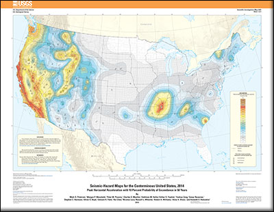
SIM3325_sheet1.pdf--map of peak horizontal acceleration with 10% probability of exceedance in 50 years
SIM3325_sheet2.pdf--map of peak horizontal acceleration with 2% probability of exceedance in 50 years
SIM3325_sheet3.pdf--map of horizontal spectral response acceleration for 0.2-second period (5 Percent of Critical Damping) with 10% probability of exceedance in 50 years
SIM3325_sheet4.pdf--map of horizontal spectral response acceleration for 0.2-second period (5 Percent of Critical Damping) with 2% probability of exceedance in 50 years
SIM3325_sheet5.pdf--map of horizontal spectral response acceleration for 1.0-second period (5 Percent of Critical Damping) with 10% probability of exceedance in 50 years
SIM3325_sheet6.pdf--map of horizontal spectral response acceleration for 1.0-second period (5 Percent of Critical Damping) with 2% probability of exceedance in 50 years
SIM3325-1.zip
SIM3325-2.zip
SIM3325-3.zip
SIM3325-4.zip
SIM3325-5.zip
SIM3325-6.zip

![]() U.S. Department of the Interior |
U.S. Geological Survey
U.S. Department of the Interior |
U.S. Geological Survey
URL: http://pubsdata.usgs.gov/pubs/sim/3325/index.html
Page Contact Information: GS Pubs Web Contact
Page Last Modified: Thursday, 01-Dec-2016 17:32:31 EST