
|
|
|
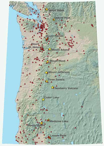
The purpose of this report is to assess the current (May, 2004) status of seismic monitoring networks at the 13 major Cascade volcanic centers. Included in this assessment are descriptions of each network, analyses of the ability of each network to detect and to locate seismic activity, identification of specific weaknesses in each network, and a prioritized list of those networks that are most in need of additional seismic stations. At the outset it should be recognized that no Cascade volcanic center currently has an adequate seismic network relative to modern-day networks at Usu Volcano (Japan) or Etna and Stromboli volcanoes (Italy). For a system the size of Three Sisters, for example, a modern-day, cutting-edge seismic network would ideally consist of a minimum of 10 to 12 short-period three-component seismometers (for determining particle motions, reliable S-wave picks, moment tensor inversions, fault-plane solutions, and other important seismic parameters) and 7 to 10 broadband sensors (which, amongst other considerations, enable detection and location of very long period (VLP) and other low-frequency events, moment tensor inversions, and, because of their wide dynamic range, on-scale recording of large-amplitude events). Such a dense, multi component seismic network would give the ability to, for example, detect in near-real-time earthquake migrations over a distance of ~0.5km or less, locate tremor sources, determine the nature of a seismic source (that is, pure shear, implosive, explosive), provide on-scale recordings of very small and very large-amplitude seismic signals, and detect localized changes in seismic stress tensor orientations caused by movement of magma bodies. However, given that programmatic resources are currently limited, installation of such networks at this time is unrealistic. Instead, this report focuses on identifying what additional stations are needed to guarantee that anomalous seismicity associated with volcanic unrest will be detected in a timely manner and, in the case of magnitude ≥ 1 earthquakes, reliably located. |
Download the text of this publication as a 28-page PDF file (6.2 MB)
For questions about the content of this report, contact Seth Moran
|
Help |
PDF help |
Publications main page |
This report is also available from:
USGS Information Services, Box 25286,
Federal Center, Denver, CO 80225
telephone: 303-202-4210; e-mail: infoservices@usgs.gov