
![]()
U.S. GEOLOGICAL SURVEY
Scientific Investigations Report 2004–5237
Conceptual Model and Numerical Simulation of the Ground-Water-Flow System in the Unconsolidated Deposits of the Colville River Watershed, Stevens County, Washington
Introduction
In recent years, increased withdrawal of ground- and surface-water supplies in several watersheds of Washington State has created concern that insufficient flows remain in streams for fish and other uses. In response, the Washington State legislature passed the Watershed Management Act of 1998 (HB 2514), which encourages and provides some funding for local watershed planning and delegates the planning to a local level. As part of this planning process, stakeholders within a Water Resources Inventory Area (WRIA) need to assess the status of water resources in the WRIA and determine whether water is available for allocation.
Surface water in the Colville River Watershed (WRIA 59, fig. 1) currently is available for further appropriation only from the mainstem of the Colville River and only from October 1 through July 15. All streams tributary to the Colville River are fully appropriated under existing water rights (Chung and Slattery, 1977). Issuance of new ground-water rights was halted in 1994 by the Washington Department of Ecology (DOE) owing to possible hydrologic connection of the ground- and surface-water systems. Although new wells for single and multi-family use are exempt, the ruling limits any major development of ground water in the Colville River Watershed.
The Colville River Watershed Planning Team (Planning Team) is working to develop a long-range watershed management plan to meet the needs of current and future water demands within the watershed, while also working to protect and improve its natural resources. The U.S. Geological Survey (USGS), in cooperation with the Planning Team, began Phase I of a two-part study in the summer of 2001 to investigate the ground-water system of the valley-fill deposits of the Colville River Watershed. Phase I was completed and the results published in Kahle and others (2003).
Following the completion of Phase I, the Planning Team requested that the USGS develop a steady-state, regional ground-water-flow model to improve understanding of the ground-water system and the regional effects of various ground-water use alternatives on the water resources of the Colville River Watershed. Development of the model, Phase II of the cooperative studies between the Planning Team and the USGS, was based on the hydrogeologic framework described in the Phase I report.
Purpose and Scope
This report documents a tool that can be used to simulate the ground-water-flow system in the Colville River Watershed. The report (1) describes the construction and calibration of the Colville River Watershed ground-water-flow model, (2) evaluates the applicability and accuracy of the model as a predictive tool for assessing low-flow conditions, and (3) discusses the limitations of the model. The broad objective of this study was to develop a better understanding of the ground-water-flow system of the Colville River Watershed to help manage the water resources. The specific objectives were to:
- Estimate the hydraulic properties of the major hydrogeologic units;
- Define and describe the regional ground-water-flow system in the unconsolidated deposits; and
- Estimate the effects of different ground-water use alternatives on the ground-water and surface-water systems.
The model was calibrated for September 2001 conditions, using 161 hydraulic-head measurements and 44 synoptic streamflow measurements. The streamflow measurements identified gaining and losing reaches over the unconsolidated valley deposits.
Description of Study Area
The Colville River Watershed occupies much of central Stevens County in northeastern Washington and covers about 1,000 mi2 (fig. 1). It is a roughly north-south oriented watershed about 45 mi long and 23 mi wide, and extends from the town of Springdale and Loon Lake at the southern end of the watershed to near the town of Kettle Falls at the northwestern extent of the watershed. The Colville River begins at the confluence of Sheep and Deer Creeks at the south end of the watershed, flows generally north to the town of Chewelah and then continues north-northwest to the town of Colville. Beyond Colville, the river follows a more westerly course and empties into Franklin D. Roosevelt Lake (also know as Lake Roosevelt) 2 mi southwest of the town of Kettle Falls.
Physiographically, the watershed is composed of hilly and mountainous terrain of the Selkirk Mountains, which is bisected by the generally north-south river valley that is in most places less than 3 mi wide. Altitudes range from 1,290 ft at the mouth of the Colville River to near 7,000 ft in the upland areas. Colville River valley, which occupies the central part of the watershed, has an altitude of 1,920 ft near Springdale to 1,620 ft at Kettle Falls, about 43 mi downstream. The low drainage divide to the south, between the north-flowing Colville River and the south-flowing Chamokane Creek is underlain by recent alluvium, glacial outwash and till, and thick clay and silt deposited in large Pleistocene lakes. These unconsolidated deposits form a shallow drainage divide in an otherwise broad and continuous valley.
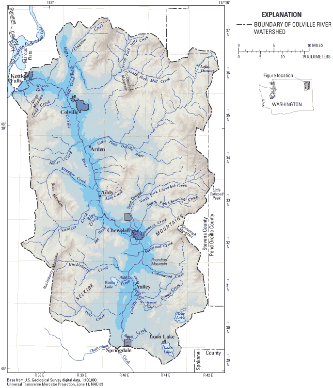
Figure 1. Location of Colville River Watershed, Stevens County, Washington.
Geologically, the watershed can be grouped into three types of formations; bedrock, glacial deposits, and valley alluvium. The bedrock, consisting of sedimentary, metamorphic, and igneous rocks, forms the hills and mountains of the watershed and underlies the lowland areas at generally unknown depths. Glacial deposits including silt, sand, gravel, clay, and till mantle much of the lowland areas and lower reaches of the hills and mountains. These sediments are the result of deposition during repeated ice advances of the Colville Lobe of the Cordilleran ice sheet during the Pleistocene Epoch. Sands and gravels deposited by glacial outwash streams are significant sources of ground water in the watershed. Recent valley alluvium is mostly limited to the Colville River valley, where it lies directly on the Pleistocene glacial deposits.
Most of the mountainous areas in the watershed are covered with pine, fir, and larch forests that are the basis for the large historical and present-day lumber industry in the area. Most agricultural activity occurs on the valley bottom and is mostly hay. The lowland areas support several towns and light commercial and industrial development, mostly in Colville and Chewelah. The estimated population for WRIA 59 is 22,430 residents based on the 2000 Census for Stevens County (Linda Kiefer, WRIA 59 Watershed Coordinator, Stevens County, written commun., March 2002). Population in the watershed has nearly doubled since the 1970s, thereby increasing the demand on present water supplies, both for drinking water and other uses. The Colville River and its tributaries are home to several species of fish, none of which are listed as endangered or threatened.
Acknowledgments
This study was completed with the assistance of many individuals and groups. The authors thank Linda Kiefer, Dick Price, and the members of the WRIA 59 Watershed Planning Team and the Stevens County Conservation District for contributing knowledge of current and historical conditions in the watershed. John Covert of the Washington State Department of Ecology's Water Resource Program provided helpful comments throughout the study. Fogle Pump and Supply provided additional drilling information that aided in the estimation of hydraulic properties.
For more information about USGS activities in Washington, visit the USGS Washington District home page .
![]()
![]()