
![]()
U.S. GEOLOGICAL SURVEY
Scientific Investigations Report 2004–5237
Conceptual Model and Numerical Simulation of the Ground-Water-Flow System in the Unconsolidated Deposits of the Colville River Watershed, Stevens County, Washington
Conceptual Model of the Ground-Water System
This section provides a generalized description and interpretation of the hydrogeologic framework of the ground-water system (the conceptual model) of the Colville River Watershed, including descriptions of the physical, lithologic, and hydrologic characteristics of the hydrogeologic units. An understanding of these characteristics is important in determining the occurrence and availability of ground water in the watershed. For a detailed description of the water resources of the Colville River Watershed, the reader is referred to Kahle and others (2003).
Geologic Setting
The geology of the Colville River Watershed is complex and comprises several types of bedrock (for example, shale, slate, dolomite, quartzite, granite, and basalt) overlain in many places with various types and thicknesses of unconsolidated sediment such as silt, sand, gravel, and clay. The sediments occur mostly as till, outwash, alluvium, and glacial-lake flood deposits. At least two periods of glaciation have influenced the topography and sedimentation of the region. Although sediments from the earliest glaciations can be identified in some deep wells, little surface evidence remains to reconstruct their depositional history. Only the most recent glacial history is recorded in exposed sediments in the study area.
During the climax of the most recent glaciation (about 15,000 years before present), most of northern Washington, including the Colville River valley, was covered by lobes of the Cordilleran ice sheet. The Okanogan Lobe, to the west of the Colville River valley, dammed the Columbia River and created a vast lake referred to as glacial Lake Columbia (Waitt and Thorson, 1983), which deposited thick, fine-grained sediments throughout much of the region.
As the Colville Lobe of the ice sheet advanced southward into the Colville River valley, large areas of outwash sands and gravels were deposited from glacial melt water, till was deposited beneath the ice, and fine-grained sediments were deposited as the lobe advanced into glacial Lake Columbia (Waitt and Thorson, 1983). The southern limit of the Colville Lobe is marked by a well-developed terminal moraine, the Springdale moraine, near the town of Springdale.
Although most of the surficial unconsolidated deposits in the study area are the result of glacial processes involving the Colville and Okanogan Lobes, the Purcell Trench Lobe in what is now northern Idaho also contributed directly to sedimentation in the southern part of the Colville River Watershed. Glacial Lake Missoula, dammed behind the Purcell Trench Lobe, was about 600 mi3 in volume and reached a maximum depth of 2,200 ft (Waitt, 1980). Large catastrophic floods occurred periodically when the ice dam of the Purcell Trench Lobe failed, sending floodwaters west and southwest. The giant, present-day dunes north of Loon Lake record floodwaters exiting westward through the Sheep Creek spillway into the Colville River valley near Springdale (Carrara and others, 1995). Following the retreat of the Purcell Trench Lobe from the Colville River Watershed, the valley floor was slightly modified as streams reworked the surficial lake sediments to form a flood plain of variable width. The modern northward flow of the Colville River is the result of the outwash and moraine divide at Springdale.
The surficial geology of the Colville River Watershed consists of the following seven geologic units summarized in Kahle and others (2003).
- Alluvial deposits (Qal): Includes channel and overbank deposits in the modern Colville River and tributary flood plains and alluvial-fan deposits at the mouths of streams tributary to the Colville River. The unit consists mostly of stratified silt, sand, gravel, and minor amounts of clay deposited by flowing water. Thickness of the unit generally is from 1 to 30 ft.
- Glaciofluvial deposits (Qgf): Includes mostly stratified and well-sorted sand-and-gravel outwash deposited by glacial meltwater and other glaciofluvial deposits, including well-stratified and well-sorted sand-and-gravel kame moraines deposited by the retreating Colville Lobe and glacial-outburst flood deposits consisting of mostly stratified sand, gravel, and boulders. Although most of the Qgf is coarse-grained outwash, lenses of silt, clay, and till occur locally. The thickness of the unit generally is from 20 to 300 ft.
- Glacial till (Qti): Includes mostly unsorted and unstratified clay, silt, sand, and gravel deposited by the Colville Lobe. The unit underlies much of the high altitude area in the watershed and locally may contain till from previous glaciations. Near Springdale, the unit includes the terminal moraine of the Colville Lobe. Locally, the unit contains stratified sand and gravel. Thickness of the unit generally is from 10 to 100 ft.
- Glaciolacustrine deposits (Qla): Includes mostly clay and silt lake sediments deposited in ice-marginal lakes. The unit underlies large areas of the Colville River valley, but is overlain by Quaternary alluvial deposits (Qal) in many areas. The unit includes thin and discontinuous beds of sand and gravel. Overall thickness of the unit generally is 20 to 300 ft.
- Mass-wasting deposits (Qmw): Includes poorly sorted angular rock fragments deposited as talus at the base of steep slopes and heterogeneous mixtures of unconsolidated surficial material and rock fragments deposited by landslides. Thickness of the unit varies, but generally is less than 100 ft.
- Organic deposits (Qor): Includes peat, woody peat, muck, and organic-rich silt and clay that commonly occur in closed depressions. Thickness of the unit is from 1 to 30 ft.
- Bedrock (Tertiary to Middle Proterozoic) (Tybr): Includes sedimentary, metasedimentary, and intrusive and extrusive igneous rocks. Specific rock types include conglomerate, sandstone, siltstone, shale, quartzite, dolomite, argillite, granite, and basalt. The unit is exposed in much of the high-altitude areas of the watershed where it is not overlain by till (Qti). The depth to bedrock in the Colville River valley beneath the unconsolidated sediments is largely unknown and likely varies considerably.
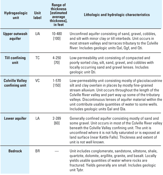
Hydrogeologic Units
The surficial geologic units described previously and the deposits at depth were differentiated into aquifers and confining units on the basis of areal extent and general water-bearing characteristics (Kahle and others, 2003). An aquifer is saturated geologic material that is sufficiently permeable to yield water in significant quantities to a well or spring, whereas a confining unit has low permeability that restricts the movement of ground water and limits the usefulness of the unit as a source of water supply. Permeabilities generally are higher in well-sorted, coarse-grained deposits than fine-grained or poorly sorted deposits. In the Colville River Watershed, saturated glacial outwash or other coarse-grained deposits form the aquifers, whereas deposits such as till or glaciolacustrine sediments form the confining units. The aquifers and confining units identified herein are referred to as hydrogeologic units because the differentiation takes into account both the geologic and hydraulic characteristics of the units. Five principal hydrogeologic units are recognized in the study area:
- Upper outwash aquifer (UA);
- Till confining unit (TC);
- Colville Valley confining unit (VC);
- Lower aquifer (LA); and
- Bedrock (BR).
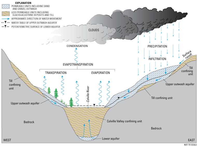
The lithologic and hydrologic characteristics of the hydrogeologic units are summarized in figure 2 and include the range of thickness for each unit based on data from field-located wells (Kahle and others, 2003). Although thin, discontinuous aquifer materials are present on the Colville River valley floor, they are not recognized in this study as a primary aquifer because of their limited extent and thickness. These deposits do, however, yield usable amounts of water, mostly to older, shallow dug wells on the valley floor. A simplified conceptual model of the hydrogeologic system of the Colville River Watershed is presented in figure 3.
(Modified from Kahle and others, 2003.)
(From Kahle and others, 2003.).
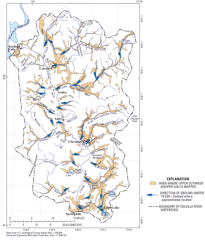
The Upper outwash aquifer (UA) is discontinuous but is a productive and widely used source of water supply. It comprises mostly glacial outwash sand and gravel (geologic unit Qgf) with lenses of clay and till occurring locally (geologic unit Qti) and some sandy alluvium along stream channels (geologic unit Qal).
The Upper outwash aquifer is present mostly in the stream valleys and terraces that are tributary to the Colville River. The average thickness of the unit is 100 ft, and the thickness at known well locations ranges from 10 to 480 ft. The unit is thickest in tributary valleys on the east side of the Colville River valley, greater than 300 ft thick in areas along the Little Pend Oreille River in Sand Canyon, along Cottonwood Creek, and between Deer and Loon Lakes.
The Till confining unit (TC) is a low-permeability unit consisting of compacted and poorly sorted clay, silt, sand, gravel, and cobbles with locally occurring sand-and-gravel lenses. The unit is present in much of the mountainous areas of the study area, where glacial till (geologic unit Qti) mantles bedrock. The estimated average thickness of the unit is 70 ft, and the thickness at known well locations ranges from 4 to 250 ft.
The Colville Valley confining unit (VC) is a thick, low-permeability unit consisting mostly of extensive glaciolacustrine silt and clay (geologic unit Qla) with locally occurring sand or gravel lenses overlain in places by fine-grained stream alluvium (geologic unit Qal). In some areas, glacial till was included with this unit where lake sediments are directly overlain by till. The confining unit is present throughout the length of Colville and Echo Valleys and in parts of some of the tributary valleys, including Mill Creek, Little Pend Oreille River, South Fork Chewelah Creek, Cottonwood Creek, and Jumpoff Joe Creek. The estimated average thickness of the Colville Valley confining unit is 150 ft, and the thickness at known well locations ranges from 1 to 570 ft. The greatest recorded thickness of the confining unit is more than 400 ft in areas near Addy and Kettle Falls.
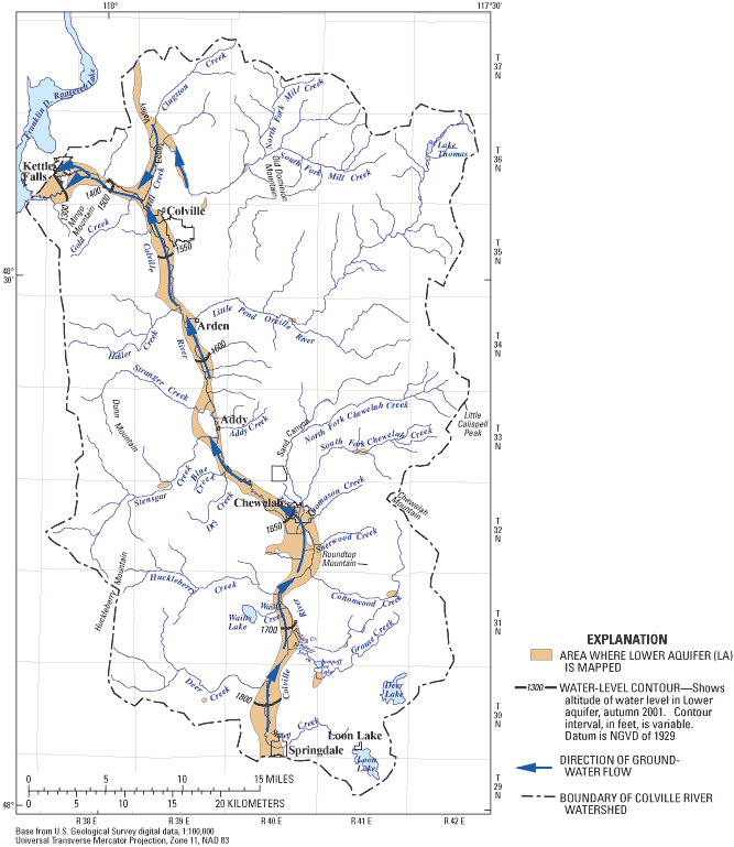
The Lower aquifer (LA) consists of sand and gravel and likely is continuous along the length of the Colville River valley and Echo valley. It is present below the Colville Valley confining unit and above the bedrock. In most of the study area, the Lower aquifer is confined and many wells completed in this unit flow at land surface. The aquifer is unconfined where exposed at land surface along the Colville River downstream of Meyers Falls. The estimated average thickness of the unit is 60 ft. This may be an underestimate of thickness, however, because few wells fully penetrate the total thickness of the unit. On the basis of available drilling records and water levels, parts of the Lower aquifer extend to the mouth of the watershed and discharge into Lake Roosevelt, probably diverging around the bedrock high near Meyers Falls — to the north beneath Kettle Falls and to the south beneath the present drainage of the Colville River.
The Bedrock (BR) underlies all previously described hydrogeologic units at depths as great as 600 ft along the Colville River valley. In most of the watershed, however, bedrock is present at or near land surface, and is the only source of ground water for landowners who live in those areas. Bedrock typically has very low permeabilities, except where it is fractured. These fractures can produce small but usable quantities of water in wells.
Hydraulic Characteristics
Horizontal hydraulic conductivity was estimated for the hydrogeologic units on the basis of drawdowns from drillers' logs that were measured after pumping wells for periods that ranged from 1 to 100 hours. Only data from those wells that had a driller's log containing discharge rate, time of pumping, drawdown, static water level, well-construction data, and lithologic log were used to estimate horizontal hydraulic conductivity. Statistical summaries of estimated horizontal hydraulic conductivities were prepared by hydrogeologic unit (table 1). The median values of estimated hydraulic conductivities for the aquifers are similar to values reported by Freeze and Cherry (1979) for similar materials: Upper outwash aquifer, 84 ft/d; and Lower aquifer, 49 ft/d (table 1). The medians of estimated hydraulic conductivities for the Till confining unit (5.6 ft/d), for the Colville Valley confining unit (110 ft/d), and for the Bedrock (1.3 ft/d) are higher than is typical for most of the material in these units because specific-capacity tests for confining units usually are from zones where lenses of coarse material exist and, in the case of bedrock, where fractures exist. As a result, the data are biased toward the more productive zones in these units and are not representative of the entire unit. The minimum hydraulic conductivities for the hydrogeologic units indicate the presence of zones of low hydraulic conductivity in most units. The range of hydraulic conductivities is at least three orders of magnitude for most units, indicating a substantial amount of heterogeneity. The methods and assumptions used in making the estimates are included in detail in Kahle and others (2003).
| Hydrogeologicunit | Numberofwells | Horizontal hydraulic conductivity (feet per day) |
||
|---|---|---|---|---|
| Minimum | Median | Maximum | ||
| Upper outwash aquifer (UA) | 24 | 1.9 | 84 | 2,400 |
| Till confining unit (TC) | 4 | 2.5 | 5.6 | 28 |
| Colville Valley confining unit (VC) | 8 | 14 | 110 | 930 |
| Lower aquifer (LA) | 17 | 1.1 | 49 | 15,000 |
| Bedrock (BR) | 3 | .0011 | 1.3 | 4.4 |
Recharge
The Upper outwash aquifer is recharged by direct precipitation in the form of rain and snow, by seepage from lakes, and by losses from streams overlying the aquifer. Recharge to the Lower aquifer likely occurs in several areas. Water-level data indicate that recharge to the Lower aquifer occurs from the southern extent of the watershed to about 3 mi north of Springdale, where vertical head gradients generally are downward. Local recharge also may occur along the walls of the Colville River valley, where coarse talus or glacial or alluvial outwash fans overlie and possibly interfinger with the otherwise continuous Colville Valley confining unit.
Estimates of average annual ground-water recharge for six subbasins within the Colville River Watershed ranged from 1.6 in. in the Haller Creek watershed to 5.0 in. in the Mill Creek watershed (Kahle and others, 2003).
Ground-Water Flow
Lateral flow of water in the aquifers generally mimics the surface-water drainage pattern of the watershed. Ground water moves from the topographically high tributary-watershed areas toward the topographically lower Colville River valley floor (fig. 3).
On the basis of available water-level data, vertical flow of ground water in the watershed generally is downward in the high-altitude areas of the tributary basins, downward on the valley floor from near Springdale to near the mouth of Sheep Creek, then upward along much of the valley floor (indicated by flowing wells) to near Colville, where vertical gradients reverse to downward near the mouth of the watershed at Lake Roosevelt. Locally, gradients are upward along gaining reaches of streams, and also are indicated by flowing wells.
Over the entire watershed, water-level altitudes in the Upper outwash aquifer range from 3,149 ft near Lake Thomas to 1,569 ft near Colville. The general distribution of lateral ground-water gradients was 60 ft/mi between Loon Lake and Springdale, 100 ft/mi northeast of Jumpoff Joe Lake westward to Valley, 90 ft/mi in Sand Canyon, 70 ft/mi in the Little Pend Oreille River drainage, and 90 ft/mi in the terrace east of Colville. The smallest gradient in the Upper outwash aquifer, 20 ft/mi, was in the area between Deer and Loon Lakes. Most of the larger lakes in the watershed (including Deer, Loon, Jumpoff Joe, Waitts, and the Little Pend Oreille Lakes) are fairly well connected with the Upper outwash aquifer, and their levels likely rise and decline with the water table. Directions of ground-water flow in the Upper outwash aquifer are shown in figure 4.
At the outlet of the Colville River Watershed, near Kettle Falls, the directions of ground-water flow are less certain, but likely diverge around the bedrock high near Meyers Falls, with flow going both toward the southwest along the present Colville River drainage and to the northwest toward the Marcus Flats area of Lake Roosevelt. Along the valley floor, water-level altitudes within the Lower aquifer range from 1,895 ft near Springdale to 1,284 ft near Kettle Falls (fig. 5). Also on the valley floor, many wells within the unit flow at land surface from 3 mi north of Springdale to the confluence of Colville River valley and Echo Valley, indicating upward ground-water gradients in those areas. Horizontal gradients are 20 ft/mi from Springdale to Valley, 7 ft/mi from Valley to Chewelah, and 5 ft/mi from Chewelah to Colville. Between Colville and Kettle Falls, however, the gradients become much greater and range from 60 to 200 ft/mi.
The ground-water divide for the Lower aquifer is uncertain, but may be near the surface-water divide for the watershed near Springdale. Additional information is needed to determine the location of the ground-water divide, as well as the southern extent of the Lower aquifer.
(From Kahle and others, 2003.)
(From Kahle and others, 2003.)
Ground-Water Discharge
Discharge from the Upper outwash aquifer takes place primarily as seepage to streams. Some interfingering of the coarse Upper outwash aquifer is likely present through the Colville Valley confining unit to the Lower aquifer, creating a direct conduit for discharge from the Upper outwash aquifer to the Colville River valley floor. Discharge also occurs as seepage along the upstream areas of lakes and through pumping from wells.
Downgradient of the Springdale area, many wells completed in the Lower aquifer flow at land surface and are points of discharge for the aquifer. The upward vertical head gradients referred to previously indicate that in some areas along the Colville River valley, ground water may move upward from the Lower aquifer, through the overlying Colville Valley confining unit, and eventually discharge to surface-water features such as the Colville River. Water pumped from wells is another form of discharge from the Lower aquifer.
Ground water discharges from the system by evapotranspiration where the water table is shallow. The total discharge by ground-water evapotranspiration is unknown, but is presumed to be insignificant compared to the other ouflows from the system.
Discharge at the lower end of the watershed near Kettle Falls is uncertain, but is likely through subsurface flow into Lake Roosevelt near the mouth of the Colville River. Ground water leaving the watershed at depth near Kettle Falls was estimated to be 25 ft3/s, applying Darcy's equation with a hydraulic conductivity of 240 ft/d, a cross-sectional area through the Lower aquifer of 240,000 ft2; and a gradient of 200 ft/mi. This estimate could be improved by redefining the cross-sectional area near the mouth of the watershed with geophysical surveys.
For more information about USGS activities in Washington, visit the USGS Washington District home page .
![]()
![]()