![]()
Scientific Investigations Report 2004–5270
By Stephen L. Harden, Stephen S. Howe, and Silvia Terziotti
Marine Corps Base Camp Lejeune is located in Onslow County in the North Carolina Coastal Plain. In support of North Carolina Department of Environment and Natural Resource requirements, Camp Lejeune is developing a site closure plan for two Resource Conservation and Recovery Act (RCRA) regulated open burn/open detonation (OB/OD) facilities located within Impact Area K-2 and Impact Area G-10, respectively. Both Impact Areas are used for training activities involving live artillery fire. The two OB/OD facilities are used to treat RCRA regulated waste munitions. To provide Base officials with information needed for assessing the quality of ground water at these sites, hydrologic data were used to characterize groundwater flow directions and hydraulic gradients in the surficial aquifer underlying the Impact Areas.
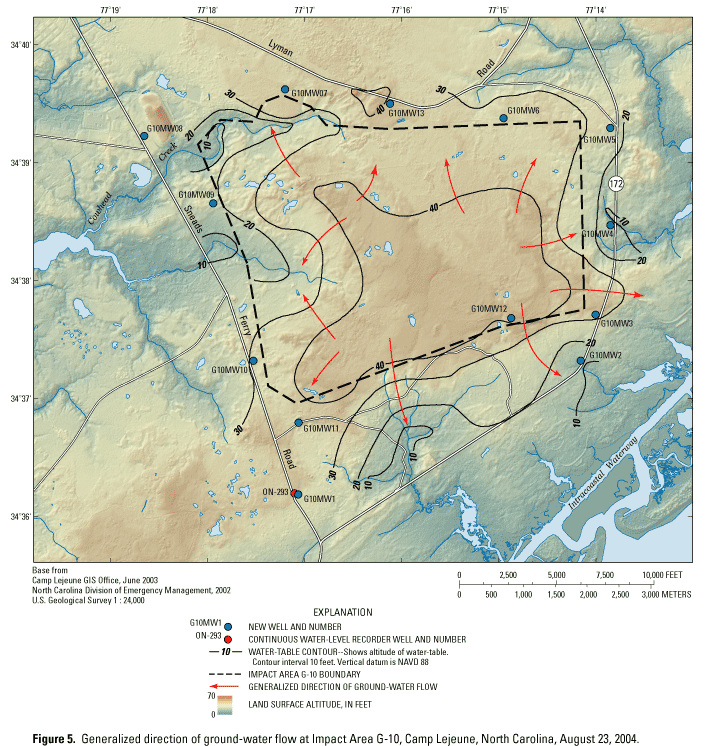
Water-level data in the unconfined surficial aquifer and potentiometric head data in the underlying Castle Hayne aquifer were compiled from existing and newly drilled wells. Water-table contour maps were developed for Impact Areas K-2 and G-10 to examine the direction of ground-water flow in the surficial aquifer. The primary directions of ground-water flow beneath K-2 are southward and eastward toward discharge zones along the New River and its tributaries. Beneath interior areas of G-10, water in the surficial aquifer flows outward in all directions toward discharge zones along local streams that drain westward to the New River or to streams that drain southward and eastward to the Intracoastal Waterway and the Atlantic Ocean.
Long-term water-level data for the period October 1994 through September 2004 at selected Camp Lejeune well sites were used to examine trends in ground-water levels and vertical hydraulic gradients between the surficial and Castle Hayne aquifers. Evaluation of water-level data for three wells in the surficial aquifer indicated no significant trends for this period of record. The apparent water-level declines in two of the three Castle Hayne wells examined are likely the result of local pumping of the Castle Hayne aquifer. Vertical hydraulic gradients determined for two well cluster sites indicate a downward flow of water from the surficial aquifer into the underlying Castle Hayne aquifer.
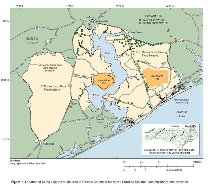
Marine Corps Base Camp Lejeune is located in Onslow County in the central part of the North Carolina Coastal Plain physiographic province (fig. 1). The Base supports a population of about 150,000 people, including active duty, dependent, retiree, and civilian personnel (Camp Lejeune, 2004). The mission of Camp Lejeune is to maintain combat-ready units for expeditionary deployment. As a means of fulfilling this mission, Camp Lejeune provides live-fire training using designated Impact Areas. Two of these sites, Impact Area K-2 and Impact Area G-10, are centrally located on the Base (fig. 1).
The North Carolina Department of Environment and Natural Resources (NCDENR), Division of Waste Management, is requiring Camp Lejeune to develop a closure plan for the two RCRA regulated OB/OD facilities located within Impact Area K-2 and Impact Area G-10, respectively, when the current Base Hazardous Waste Management Permit expires in 2007. The two OB/OD facilities are used to treat RCRA regulated waste munitions. The plan includes a water-quality assessment of the ground water beneath these sites. Prior to installing monitoring wells for ground-water sampling, the direction of ground-water flow and associated hydraulic gradients in the surficial aquifer must be determined. In 2003, the U.S. Geological Survey (USGS) began a study to examine ground-water flow in the surficial aquifer at Impact Areas K-2 and G-10 to provide Camp Lejeune with information needed to optimize the placement of water-quality monitoring wells near these sites.
The primary water-supply source at Camp Lejeune is the Castle Hayne aquifer. The primary water-supply source in Onslow County and other areas of the Coastal Plain historically has been the Black Creek aquifer. Excessive ground-water withdrawals, however, have lowered the potentiometric head in the Black Creek aquifer, which has prompted the NCDENR, Division of Water Resources, to implement reductions in withdrawals from this water-supply aquifer as part of the Central Coastal Plain Capacity Use Area (North Carolina Department of Environment and Natural Resources, 2004a). For this reason, the Castle Hayne aquifer has become an increasingly important source of water supply for Onslow County.
In the Camp Lejeune area, the surficial aquifer and the Castle Hayne aquifer are separated by the Castle Hayne confining unit. In areas where this confining unit is not present, ground water in the overlying surficial aquifer can move directly into the Castle Hayne aquifer. Where present, the Castle Hayne confining unit helps impede the flow of water between the aquifers.
As the demand for water supply increases, the greater demand on the Castle Hayne aquifer by the Base and Onslow County can potentially alter the natural ground-water flow system. Some of the water-supply wells currently used by Camp Lejeune and Onslow County are located in the vicinity of the Impact Areas (fig. 1). Hydrologic stresses induced in the Castle Hayne aquifer by water-supply pumping may enhance the downward flow of ground water from the surficial aquifer into the underlying Castle Hayne aquifer.
The purpose of this report is to present the results of an investigation to characterize ground-water flow directions and hydraulic gradients in the surficial aquifer near Impact Areas K-2 and G-10 at Camp Lejeune (fig. 1). The scope of work included a compilation of water-level data in the unconfined surficial aquifer and potentiometric head data in the confined Castle Hayne aquifer from existing and newly drilled wells. The water-level information was used to contour the water-table surface of the surficial aquifer and determine vertical hydraulic gradients between the surficial and Castle Hayne aquifers near Impact Areas K-2 and G-10. This report provides information needed by water-resource managers at Camp Lejeune to optimize the placement of water-quality monitoring wells near Impact Area K-2 and Impact Area G-10. Results of this study also will provide Base officials with information on ground-water level conditions in the surficial aquifer and underlying Castle Hayne aquifer.
Marine Corps Base Camp Lejeune is bounded to the north by the City of Jacksonville, to the east by State Highways 24 and 172, to the west by State Highway 50, and to the south by the Atlantic Ocean (fig. 1). The Base covers an area of approximately 164 square miles (mi2) and is bisected by the New River. The New River is a tidal estuary that covers approximately 18 percent (30 mi2) of the Base and flows into the Atlantic Ocean.
Impact Area K-2 is west of the New River and Impact Area G-10 is east of the New River (fig. 1). Impact Area K-2 encompasses 6.1 mi2 of the Base and Impact Area G-10 encompasses 7.8 mi2. Land-surface altitude ranges from about 0 to 35 feet (ft) above sea level at K-2 and 10 to 50 ft above sea level at G-10. Land cover in the Impact Areas primarily consists of mixed forest vegetation, wetlands, and disturbed areas from training exercises. Impact Area G-10 is located closer to commercial and residential development than Impact Area K-2, which is located within a relatively secluded area. Surface-water runoff at Impact Area K-2 flows to the south and east to tributaries of the New River. Surface-water runoff at Impact Area G-10 flows to the west to tributaries of the New River and to the south and east to tributaries that drain to the Intracoastal Waterway and Atlantic Ocean.
The most comprehensive study of the hydrogeologic framework of the North Carolina Coastal Plain to date was conducted by Winner and Coble (1996). This study was a regional investigation that identified 10 aquifers and confining units that compose the North Carolina Coastal Plain aquifer system. Correlation of the aquifers is illustrated in 18 hydrogeologic sections; 2 of these hydrogeologic sections were completed in or near Camp Lejeune. These sections provide general information about the individual hydrogeologic units in or near Camp Lejeune. Because of the regional scope of the work, however, these sections do not present detailed hydrogeology at the Base scale.
A hydrogeologic framework for the principal freshwater-bearing aquifers at Camp Lejeune, including the surficial, Castle Hayne, Beaufort, and Peedee aquifers, was developed by Cardinell and others (1993). Geological, geophysical, and hydrologic data were compiled and evaluated for more than 180 wells to develop the hydrogeologic framework. Hydrogeologic sections and maps are presented and discussed for the individual aquifers.
A seismic-reflection survey at Camp Lejeune was conducted by Cardinell and others (1990) to examine the continuity of hydrogeologic units underlying the New River and Intracoastal Waterway. Harned and others (1989) performed an initial assessment of the hydrologic conditions and the hydrogeologic setting at Camp Lejeune. LeGrand (1959) examined well data to identify zones in the Castle Hayne aquifer that were most suitable for providing water to supply wells.
This report is based on work conducted by the USGS, Raleigh, North Carolina, in cooperation with the Department of the Navy, U.S. Marine Corps, Camp Lejeune, North Carolina. The authors thank Bob Lowder of the Environmental Management Division and Duane Richardson of the Range Control Office at Camp Lejeune for their help and support during this project. Our appreciation is extended to USGS personnel who assisted with this project and report, especially Eve Kuniansky who provided technical assistance and Eric Sadorf who installed wells at the study sites.
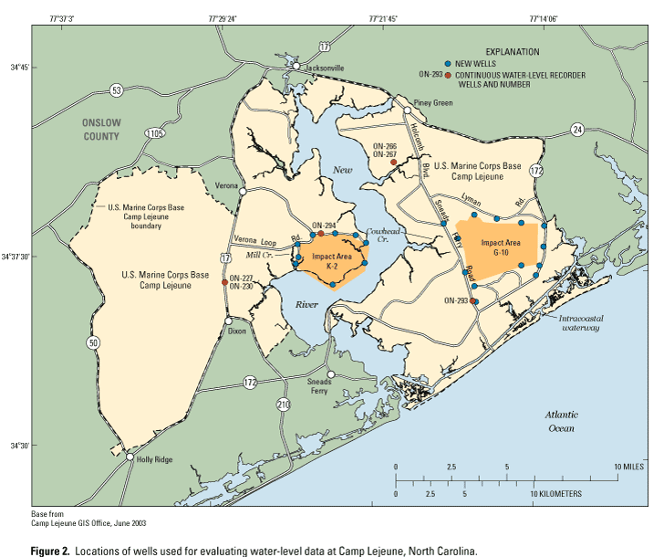
The water-level data that were used to develop water-table surface maps and examine vertical hydraulic gradients were obtained from existing wells and new wells installed for this investigation. The existing wells include USGS long-term water-level monitoring wells (fig. 2). New wells were drilled along the perimeter of Impact Areas K-2 and G-10 to evaluate local conditions of ground-water flow in the surficial aquifer (fig. 2).
Water-level data were compiled from the USGS National Water Information System (NWIS) database and from an inventory of existing wells on the Base and nearby in Onslow County. Additionally, geographic information system (GIS) coverages, including high-resolution light detection and ranging (LIDAR) land-surface data (20-centimeter vertical accuracy), streams, and aerial photography, were used to help analyze the topographic characteristics of the Impact Areas to aid in the selection of drilling locations for additional wells tapping the surficial aquifer. A trailer-mounted hollow-stem auger drilling rig was used to install 9 wells around the perimeter of Impact Area K-2 and 13 wells around the perimeter of Impact Area G-10 (fig. 2). Construction information for the new and existing wells utilized in this study is summarized in table 1. Detailed construction forms provided to the State of North Carolina for the new wells are provided in Appendix 1.
Water-level data collected by the USGS are periodic measurements or continuous data obtained from water-level recorders. The water-level data are stored in the USGS NWIS database and are available to the public on the Internet (U.S. Geological Survey, 2004). With the exception of wells K2MW8 and K2MW9, water levels in the unconfined surficial aquifer were measured on August 23, 2004, to provide the data needed to construct water-table surface maps near Impact Areas K-2 and G-10 (table 2). Wells K2MW8 and K2MW9 could not be measured on August 23, 2004, because of site-access restrictions; thus, it was necessary to use water-level data obtained during the installation of these wells on February 11, 2004, and March 11, 2004, respectively. Water-level measurements at each well were determined using an electronic water-level indicator. Additionally, hydrographs from a network of wells used for recording continuous ground-water levels at Camp Lejeune were examined to determine the magnitude of seasonal water-level fluctuations and vertical gradient between the surficial aquifer and the Castle Hayne aquifer. Continuous measurements of ground-water levels at the well network are made using a float system and incremental encoder. The water-level information is logged hourly using a data recorder.
Because access to the interior of the Impact Areas was prohibited for safety reasons, it was not possible to install wells and collect water-level information directly from the interior areas of Impact Areas K-2 and G-10. Therefore, an approach was needed for estimating water-level altitudes in the interior areas of the Impact Areas to aid in the development of water-table maps for the study sites.
As an alternative approach to direct measurement, a linear regression was developed from available perimeter-well data and land-surface altitude. High-resolution topography from LIDAR data (North Carolina Division of Emergency Management, 2002) was used to estimate water-table contours within the interior of each Impact Area. The computer-generated water-table contours were smoothed and used in combination with stream-altitude data (assumed ground-water discharge areas) and water-level data from perimeter wells along the site boundaries to produce generalized water-table contour maps. The general direction of ground-water flow is indicated on the maps by arrows drawn perpendicular to the water-table contours. The water-table contour maps produced by this approach are considered qualitative and need to be substantiated with water-level data obtained directly from the interior of the Impact Areas.
Marine Corps Base Camp Lejeune is situated on an eastward-thickening wedge of mostly unconsolidated sediment consisting of sands, silts, clays, shells, sandstone, and limestone that were deposited in marine or near-shore environments (Harned and others, 1989; Winner and Coble, 1996). These sedimentary deposits overlie igneous and metamorphic basement rocks and range in age from Cretaceous to Holocene. The sedimentary deposits are more than 1,000 ft thick.
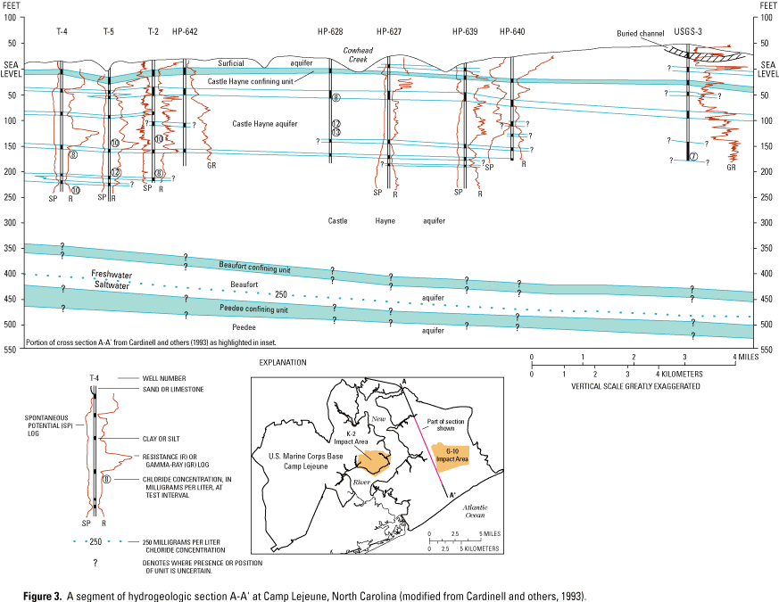
The principal freshwater-bearing aquifers underlying Camp Lejeune include the surficial, Castle Hayne, Beaufort, and Peedee aquifers. A hydrogeologic section showing these aquifers and their respective confining units in the vicinity of Impact Areas K-2 and G-10 is provided in figure 3. The focus of this study is on the surficial aquifer and the Castle Hayne aquifer, the principal source of water supply for Camp Lejeune.
Based on the hydrogeologic framework developed for Camp Lejeune by Cardinell and others (1993), the thickness of the surficial aquifer is estimated to range from about 0 to 40 ft at Impact Area K-2 and from 10 to 70 ft at Impact Area G-10. The surficial aquifer generally is thickest in the interstream divide areas and typically becomes thinner near surface-water drainage areas (fig. 3). Tributaries of the New River, including Mill Creek along the western perimeter of site K-2 and Cowhead Creek along the northwestern boundary of site G-10 (fig. 2), may incise the surficial aquifer at lower elevations (Cardinell and others, 1993). Wells installed around the perimeters of Impact Areas K-2 and G-10 during this study (fig. 2; Appendix 1) indicate the presence of silty fine sand, clay, and sandy clay to depths of 20 ft below land surface.
The Castle Hayne confining unit isopach map developed by Cardinell and others (1993) indicates that the confining unit underlying the surficial aquifer at Impact Areas K-2 and G-10 is approximately 5 ft thick; however, detailed information is insufficient to determine if the confining unit is laterally continuous throughout the study sites. The altitude of the top of the Castle Hayne aquifer at Impact Area K-2 ranges from about sea level to 25 ft below sea level in the western and eastern parts of the site, respectively. In some areas of Camp Lejeune, the New River and some of its tributaries have incised the Castle Hayne confining unit to the underlying Castle Hayne aquifer (Cardinell and others, 1993), which may be the case for Mill Creek along the western boundary of K-2. The altitude of the top of the Castle Hayne aquifer at Impact Area G-10 ranges from about 5 ft below sea level near the northern boundary to about 25 ft below sea level near the southern boundary. It is unclear whether Cowhead Creek along the northern part of the site has incised the Castle Hayne confining unit to the underlying Castle Hayne aquifer. The Castle Hayne aquifer is more than 225 ft thick at site K-2 and 400 ft thick at site G-10. Cardinell and others (1993) indicated that the upper part of the Castle Hayne aquifer in the Camp Lejeune area primarily consists of calcareous sand that contains some beds of clay and silt. Consolidated limestone and sandy limestone interbedded with clay and sand are in the lower part of the aquifer. More detailed information on the hydrogeologic setting at Camp Lejeune is discussed by Harned and others (1989) and Cardinell and others (1993).
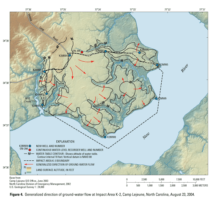
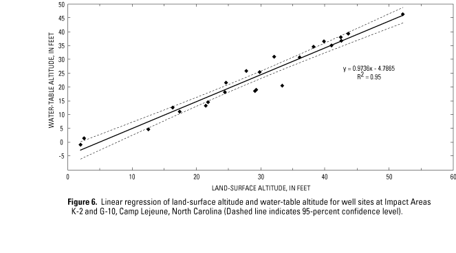
Generalized water-table maps were developed to examine the direction of ground-water flow in the surficial aquifer at Impact Areas K-2 (fig. 4) and G-10 (fig. 5). The maps are based on water-level data obtained from the perimeter wells around both sites (table 1; fig. 2). The land-surface altitudes, based on high-resolution topography from LIDAR data, and water-level altitudes from the well sites (table 2) were used to develop the linear regression presented in figure 6. This regression equation was used with the GIS to estimate water-table altitudes in the perimeters of the Impact Areas. A water-table grid at a 20-ft by 20-ft scale over each Impact Area was calculated by multiplying the LIDAR surface-altitude data by the slope and subtracting the intercept of the regression equation. The computed water-table data were combined with stream-altitude data derived from the LIDAR coverages and water-level data from the perimeter wells to produce the generalized water-table contour maps. For the purpose of this report, these maps are considered useful for examining the large-scale pattern of ground-water flow in the surficial aquifer at the study sites. Complete understanding of exact locations of water-table contours and directions of flow at localized scales will require the direct measurement of ground-water levels within the interiors of the Impact Areas.
Conceptually, ground water in the shallow surficial aquifer moves from areas of high hydraulic head in interstream divides toward areas of low hydraulic head at surface-water discharge areas (fig. 4, fig. 5). The direction of flow is perpendicular to the water-table contours. The highest hydraulic head at Impact Area K-2 is near the northwestern part of the site, as denoted with the 40-ft contour line (fig. 4). Ground water in this area flows southeastward into Impact Area K-2. Generally, ground-water flow in the interior of K-2 has a southward and eastward trend. Locally, ground water may flow in other directions depending on specific location and proximity to streams. Ultimately, ground-water discharge from the surficial aquifer at K-2 is directly to the New River or its tributaries. At Impact Area G-10, water in the surficial aquifer flows radially from interior areas of the site toward the site boundaries in all directions (fig. 5). Depending on location, ground water flows toward discharge zones along local streams that drain westward to the New River or to streams that drain southward and eastward to the Intracoastal Waterway.
Recharge to the surficial aquifer at Impact Areas K-2 and G-10 occurs from precipitation. Ground water in the surficial aquifer discharges to local streams and the New River. Some of the shallow ground water moves down through the Castle Hayne confining unit into the underlying Castle Hayne aquifer. The movement of ground water between the surficial and Castle Hayne aquifers is controlled by the magnitude of vertical gradients between the aquifers and by the hydraulic conductivity of the Castle Hayne confining unit. Cardinell and others (1993) estimated the vertical hydraulic conductivity of the Castle Hayne confining unit to range from 0.0014 to 0.41 foot per day (ft/day) and indicated that the confining unit may only partially restrict the vertical flow of ground water between the surficial and Castle Hayne aquifers. The vertical flow of water between the surficial and Castle Hayne aquifers also can occur where sinkholes are present. Sinkholes result from the collapse of surficial materials into voids and cavities created by the dissolution of limestone materials, such as those of the Castle Hayne aquifer. Water-level changes associated with ground-water withdrawals are one of the principal anthropogenic mechanisms for inducing sinkhole development (Newton, 1987).
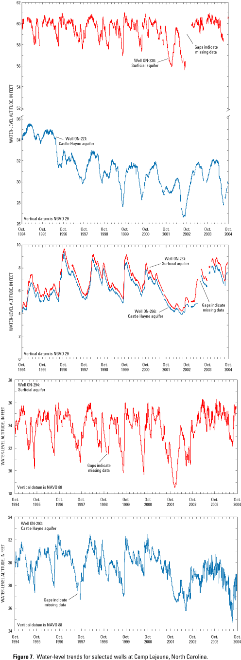
Water-level measurements collected over long time periods can provide information on the effects of climatic or human-induced hydrologic stresses on the ground-water system (Taylor and Alley, 2001). Ground-water level data from October 1994 through September 2004 were used to examine trends in ground-water levels and vertical hydraulic gradients within and between the surficial and Castle Hayne aquifers for selected wells near the study area. Water-level data were examined from wells located west of the New River, including well ON-294 in the surficial aquifer and well pair ON-230 and ON-227 in the surficial and Castle Hayne aquifers, respectively (fig. 2). East of the New River, water-level data were examined from well ON-293 in the Castle Hayne aquifer and well pair ON-267 and ON-266 in the surficial and Castle Hayne aquifers, respectively (fig. 2)
Overall, no apparent trends in water levels were noted for the period October 1994 through September 2004 in surficial aquifer wells ON-230, ON-267, and ON-294 (fig. 7). From October 1994 through the recent drought years of 2001 and 2002, water levels at these locations fluctuated about 5 ft in ON-230, 5.5 ft in ON-267, and 7.5 ft in ON-294. Excluding the drought period, the seasonal water-level fluctuations in wells ON-230, ON-267, and ON-294 typically range from about 2.5 to 5 ft. Most water-level fluctuations in the surficial aquifer are likely from seasonal differences in the amount of ground-water recharge. In general, water levels increase from November through March and decline from April through October, when higher evapotranspiration occurs. The water-level fluctuations observed for the surficial aquifer at these well sites likely represent those that occur in Impact Areas K-2 and G-10.
In the Castle Hayne aquifer, long-term water levels for the 10-year period of record in well ON-227 fluctuated about 9 ft and had an overall downward trend during the period October 1994 through September 2004 (fig. 7). From October 1994 through early 1996, water levels in ON-227 generally were higher than an altitude of 34 ft. From early 1999 through September 2004, seasonal high water-level altitudes in ON-227 have been about 32 ft or lower. This pattern was not observed in the surficial aquifer well ON-230 at the same location where water levels fluctuated within a fairly uniform range, which indicates confinement of the Castle Hayne aquifer in this area west of the New River.
Water levels fluctuated about 5.5 ft in Castle Hayne well ON-266 during the period October 1994 through September 2004 with no apparent trend noted (fig. 7). Water-level fluctuations in well ON-266 exhibited the same pattern as those observed in surficial aquifer well ON-267, which indicates that seasonal differences in recharge and potential effects of local pumping have a similar influence on the surficial and Castle Hayne aquifers at this location on the east side of the New River. The lower water-level altitudes observed in the surficial aquifer well ON-267 and Castle Hayne well ON-266 during the period October 1994 through July 1996 compared to the period August 1996 through July 2001 is in direct contrast with the water-level pattern observed in Castle Hayne well ON-227 on the opposite (west) side of New River, where the initially higher water levels were followed by a decline in water levels (fig. 2, fig. 7).
The contrasting pattern noted between Castle Hayne wells ON-266 and ON-227 may be related to spatial and temporal differences in ground-water pumping at the Base. The apparent decline in water levels in well ON-227 likely reflects the removal of ground water from storage through local pumping of the Castle Hayne aquifer at Dixon (fig. 1). The removal of ground water from storage also may explain the water-level pattern noted in Castle Hayne well ON-293 after October 2002. With the exception of well ON-293, seasonal high water-level altitudes at all surficial and Castle Hayne wells presented in figure 7 have recovered to pre-drought conditions.
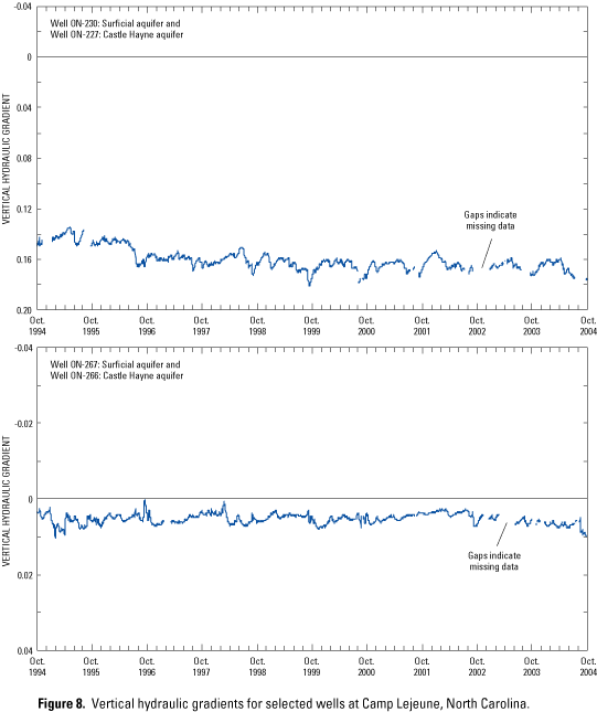
For the two well-cluster sites, vertical hydraulic gradients were calculated to determine the vertical direction (upward or downward) of ground-water flow between the surficial and Castle Hayne aquifers. The vertical gradient calculated from a shallow well to a deeper well represents the difference in hydraulic head (in feet) divided by the distance between the midpoints of the screened intervals or open borehole for the wells (in feet). The value of vertical gradient is reported as a unitless number. A positive vertical gradient value represents downward flow; thus, the surficial aquifer is potentially recharging the Castle Hayne aquifer. A negative vertical gradient represents an upward flow, indicating that the Castle Hayne aquifer is potentially discharging to the overlying surficial aquifer.
Water-level data from well pair ON-230 and ON-227, and well pair ON-267 and ON-266 were used to calculate vertical gradients between the surficial and Castle Hayne aquifers (fig. 2, fig. 8). The positive values of vertical gradient at well pair ON-230 and ON-227 indicate the potential for downward movement of shallow ground water from the surficial aquifer into the underlying Castle Hayne aquifer at that location (west of the New River). The vertical gradient values also appear to be increasing with time, indicating that the downward flow of water between the two aquifers has increased during the 10-year period of record. This increase in vertical gradient is a result of water levels in the Castle Hayne aquifer declining at a faster rate (from water-supply pumping), as compared to water levels in the overlying surficial aquifer. The decline in water levels observed in Castle Hayne well ON-227 appears to be in response to pumping from Onslow County supply wells at Dixon (fig. 1, fig. 2), which began in the early 1990s. Based on local water-supply plans for Onslow County (North Carolina Department of Environment and Natural Resources, 2004b), the average daily withdrawal of ground water from the Dixon supply wells increased from 1.13 million gallons per day (Mgal/d) in 1997 to 4.51 Mgal/d in 2002.
The values of vertical gradient calculated between surficial aquifer well ON-267 and Castle Hayne well ON-266 (fig. 8) are slightly positive and fall within a fairly confined range, indicating the potential for downward movement of shallow ground water from the surficial aquifer into the underlying Castle Hayne aquifer at this location (east of the New River). The hydraulic head difference between the surficial and Castle Hayne aquifers is less than about 1 ft at this well-pair site and, as previously mentioned, the same pattern of water-level fluctuations is observed for both aquifers. This information indicates that at the ON-267 and ON-266 well-pair site, there is little or no confinement of the Castle Hayne aquifer. Local pumping influences on water levels also appear possible, as indicated by the lower water-level altitudes during the period October 1994 through July 1996 compared to the period August 1996 through July 2001.
Based on this evaluation of long-term water-level records at Camp Lejeune, it is likely that the surficial aquifer at Impact Areas K-2 and G-10 serves as a source of recharge to the underlying Castle Hayne aquifer. In addition, the possible presence of sink holes at the Impact Areas can facilitate direct exchange of water between the surficial and Castle Hayne aquifers. The potential effects of local water-supply pumping on the ground-water flow system at the Impact Areas currently are not known. Enlarging cones of depression in the Castle Hayne aquifer could alter ground-water flow in the Impact Areas and enhance the downward movement of shallow ground water from the surficial aquifer into the underlying Castle Hayne water-supply aquifer.
Marine Corps Base Camp Lejeune is located in Onslow County in the central part of the North Carolina Coastal Plain. As required by NCDENR, Camp Lejeune has begun developing a closure plan for two RCRA regulated OB/OD facilities located within Impact Area K-2 and Impact Area G-10, respectively. Both Impact Areas are used for training activities involving live artillery fire. The two OB/OD facilities are used to treat RCRA regulated waste munitions. An assessment of ground-water quality at the two Impact Areas is needed as part of the closure plan. The focus of this study was to characterize ground-water flow directions and hydraulic gradients in the surficial aquifer at the Impact Areas to provide water-resource managers at the Base with information needed to optimize well locations for assessing water-quality conditions at the sites.
The scope of work included a compilation of water-level data in the unconfined surficial aquifer and potentiometric head data in the confined Castle Hayne aquifer from existing and newly drilled wells. The water-level data were used to map the water-table surface of the surficial aquifer and determine vertical hydraulic gradients between the surficial and Castle Hayne aquifers near Impact Areas K-2 and G-10. During August 2003, water levels were measured in the unconfined surficial aquifer to provide the data necessary to construct water-table surface maps. These water levels were combined with LIDAR-derived land-surface altitudes to develop a linear regression that was used to estimate water-table altitudes in the perimeter of the Impact Areas. This information was combined with stream-altitude data to produce generalized water-table maps for each Impact Area.
Ground water in the shallow surficial aquifer at Impact Areas K-2 and G-10 moves from areas of high hydraulic head in interstream divides toward areas of low hydraulic head at surface-water discharge zones. In the northwestern part of Impact Area K-2, ground water flows southeastward into interior parts of the site. The major direction of ground-water flow in site K-2 is southward and eastward toward discharge zones along the New River and its tributaries. At Impact Area G-10, water in the surficial aquifer flows from interior areas of the site outward toward the site boundaries in all directions. Ground water flows toward discharge zones along local streams that drain westward to the New River or to streams that drain southward and eastward to the Intracoastal Waterway.
Although most of the recharge from precipitation to the surficial aquifer at Impact Areas K-2 and G-10 discharges to local streams and the New River, some of the recharge moves downward from the surficial aquifer into the underlying Castle Hayne aquifer. Long-term water-level data for the period October 1994 through September 2004 at selected Camp Lejeune well sites were used to examine trends in ground-water fluctuations. Evaluation of water-level data for three wells in the surficial aquifer indicated no important temporal trends for the period October 1994 through September 2004. Water-level data also were evaluated for three wells in the Castle Hayne aquifer for this same period. The apparent decline in water levels noted in two of the wells likely results from removal of ground water from storage by local pumping of the Castle Hayne aquifer.
The long-term water-level data also were used to examine vertical hydraulic gradients between the surficial and Castle Hayne aquifers. The positive values of vertical gradient determined for two well-cluster sites at Camp Lejeune indicate a downward flow of water from the surficial aquifer into the underlying Castle Hayne aquifer. At Impact Areas K-2 and G-10, the surficial aquifer likely serves as a source of recharge to the underlying Castle Hayne aquifer.
| Return to the | SIR 2004-5270 Home Page |
| North Carolina District Home Page |
| USGS | Biology | Geology | Geography | Water | Open-File Reports | Water Related Reports |
|
U.S. Department of the Interior, U.S. Geological Survey
Maintainer: Publications Team Last update: Thursday, 01-Dec-2016 20:11:08 EST Privacy Statement || Disclaimer || Accessibility URL: https://pubsdata.usgs.gov/pubs/sir/2004/5270/report.html |
|