
Scientific Investigations Report 2005-5013
In cooperation with the City of Hamilton and the Hamilton to New Baltimore Ground Water Consortium
Estimation of Hydraulic Properties
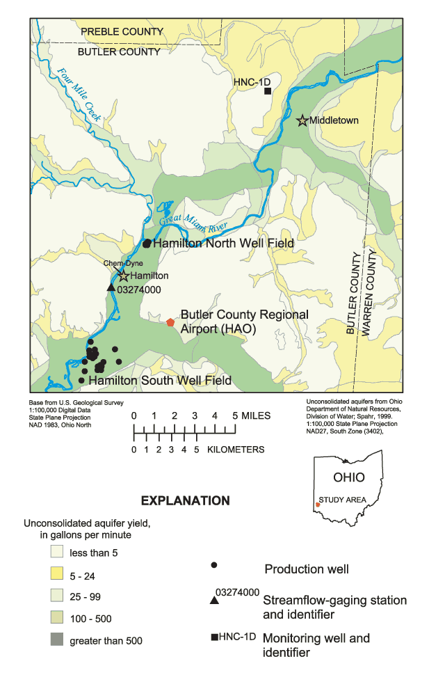
Figure 1. Location of Hamilton North and South Well Fields and glacial-aqui...
Figure 2. Location of wells and piezometers used to determine aquifer chara...
Figure 3. Stratigraphic section A-A' through the north part of the Hamilton...
Figure 4. Stratigraphic section B-B' through the Hamilton North Well Field,...
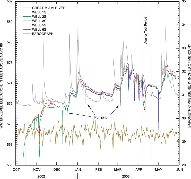
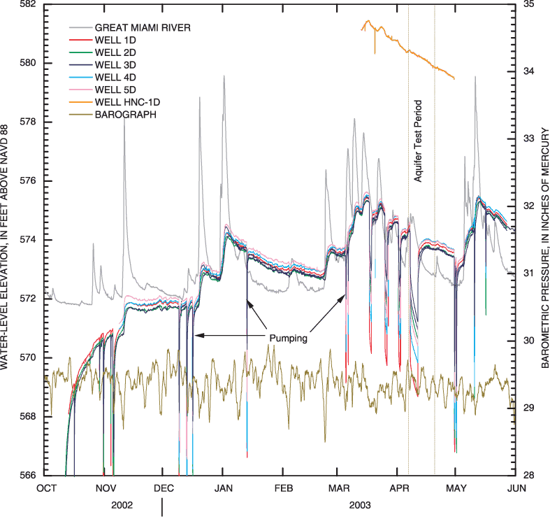
Figure 5. Water levels in shallow monitoring wells at Hamilton North Well F...
Figure 6. Water levels in deep monitoring wells at Hamilton North Well Fiel...
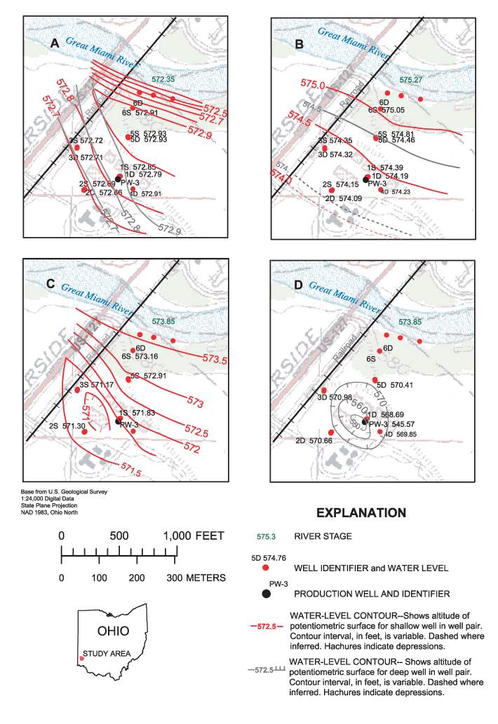
Figure 7. Water-level contours in Hamilton North Well Field during A, no pu...
Figure 8. Water levels in the Great Miami River and in shallow wells along ...
Figure 9. Water levels in the Great Miami River and in deep wells along a g...
Figure 10. Maximum drawdown corrected for river stage and partial penetrati...
Figure 11. Composite drawdown for monitoring wells at Hamilton North Well F...
Figure 12. Composite drawdown for monitoring wells at Hamilton North Well F...
Figure 1-1. Description of lithology and results of grain-size analyses for...
Figure 1-2. Description of lithology and results of grain-size analyses for...
Figure 1-3. Description of lithology and results of grain-size analyses for...
Figure 1-4. Description of lithology for well 4D.
Figure 1-5. Description of lithology and results of grain-size analyses for...
Figure 1-6. Description of lithology and results of grain-size analyses for...
Table 1. Boring and well information for Hamilton North Well Field aquifer ...
Appendix 2. Water-level elevations in piezometers, in the Great Miami River...
| Multiply | By | To obtain |
|---|---|---|
| Length | ||
| inch (in.) | 2.54 | centimeter (cm) |
| inch (in.) | 25.4 | millimeter (mm) |
| foot (ft) | 0.3048 | meter (m) |
| mile (mi) | 1.609 | kilometer (km) |
| Area | ||
| square foot (ft2) | 929.0 | square centimeter (cm2) |
| square foot (ft2) | 0.09290 | square meter (m2) |
| Volume | ||
| gallon (gal) | 0.003785 | cubic meter (m3) |
| cubic foot (ft3) | 0.02832 | cubic meter (m3) |
| Flow rate | ||
| foot per day (ft/d) | 0.3048 | meter per day (m/d) |
| gallon per minute (gal/min) | 0.06309 | liter per second (L/s) |
| gallon per day (gal/d) | 0.003785 | cubic meter per day (m3/d) |
| million gallons per day (Mgal/d) | 0.04381 | cubic meter per second (m3/s) |
| inch per year (in/yr) | 25.4 | millimeter per year (mm/yr) |
| Pressure | ||
| inch of mercury at 60ºF (in. Hg) | 3.377 | kilopascal (kPa) |
| inch of mercury at 60ºF (in. Hg) | 70.7262 | Pounds per square foot (1b/ft2) |
| Specific capacity | ||
| gallon per minute per foot [(gal/min)/ft)] | 0.2070 | liter per second per meter [(L/s)/m] |
| Hydraulic conductivity | ||
| foot per day (ft/d) | 0.3048 | meter per day (m/d) |
| Hydraulic gradient | ||
| foot per mile (ft/mi) | 0.1894 | meter per kilometer (m/km) |
| Transmissivity* | ||
| foot squared per day (ft2/d) foot squared per day (ft2/d) | 0.09290 7.4805 | meter squared per day (m2/d) gallons per day per foot (gal/d/ft) |
Verticle coordinate information is referenced to the North American Vertical Datum of 1988 (NAVD 88). Horizontal coordinate information is referenced to the North American Datum of 1983 (NAD 83).
Altitude or elevation, as used in this report, refers to distance above the vertical datum.
*Transmissivity: The standard unit for transmissivity is cubic foot per day per square foot times foot of
aquifer thickness [(ft3/d/ft2]ft. In this report, the mathematically reduced form, foot squared per day (ft2/d),
is used for convenience.
The Great Miami River Buried Valley Aquifer System is one of the most productive sources of potable water in the Midwest, yielding as much as 3,000 gallons per minute to wells. Many water-supply wells tapping this aquifer system are purposely placed near rivers to take advantage of induced infiltration from the rivers.
The City of Hamilton's North Well Field consists of 10 wells near the Great Miami River, all completed in the lower Great Miami River Buried Valley Aquifer System. A well-drilling program and a multiple-well aquifer test were done to investigate ground-water flow directions and to estimate aquifer hydraulic properties in the lower part of the Great Miami River Buried Valley Aquifer System. Descriptions of lithology from 10 well borings indicate varying amounts and thickness of clay or till, and therefore, varying levels of potential aquifer confinement. Borings also indicate that the aquifer properties can change dramatically over relatively short distances. Grain-size analyses indicate an average bulk hydraulic conductivity value of aquifer materials of 240 feet per day; the geometric mean of hydraulic conductivity values of aquifer material was 89 feet per day. Median grain sizes of aquifer material and clay units were 1.3 millimeters and 0.1 millimeters, respectively.
Water levels in the Hamilton North Well Field are affected by stream stage in the Great Miami River and barometric pressure. Bank storage in response to stream stage is evident. Results from a multiple-well aquifer test at the well field indicate, as do the lithologic descriptions, that the aquifer is semiconfined in some areas and unconfined in others. Transmissivity and storage coefficient of the semiconfined part of the aquifer were 50,000 feet squared per day and 5x10⁻⁴, respectively. The average hydraulic conductivity (450 feet per day) based on the aquifer test is reasonable for glacial outwash but is higher than calculated from grain-size analyses, implying a scale effect. Although the part of the lower Great Miami River Buried Valley Aquifer System where the Hamilton North Well Field is located is semiconfined, unconfined, or locally confined and not directly connected to the Great Miami River, the discontinuity of the clay/till layers beneath the river indicates that other, deeper parts of the aquifer system may be directly connected to the Great Miami River.
Ground water in the Great Miami River Buried Valley Aquifer System (GMR-BVAS) has been a water source since the early 19th century, and domestic and industrial growth in the Great Miami River Valley can be directly attributed to plentiful ground-water resources. The GMR-BVAS is a highly productive sand and gravel aquifer system contained in a buried valley and is one of the most productive sources of ground water in the Midwestern United States. It is recognized as a Sole-Source Aquifer by the U.S. Environmental Protection Agency (2004). The buried valley was formed during interglacial episodes of the Pleistocene Epoch and was subsequently filled with sand and gravel outwash (Spieker, 1968). Laterally and vertically discontinuous clay or till layers within the outwash can act as barriers to downward flow (Klaer and Thompson, 1948). The buried valley averages 2 mi in width and 150–200 ft in depth; yields to wells in the GMR-BVAS are as high as 3,000 gal/min (fig. 1).
The GMR-BVAS supplies drinking water to approximately 97 percent of the 1.6 million people in the Great Miami River basin (Debrewer and others, 2000). Previous studies at the public-supply wells along the Great Miami River (Dumouchelle, 1998; Sheets and others, 2002) have shown that aquifer interaction with the Great Miami River is an important influence on ground-water flow and transport in the BVAS. Induced infiltration (or bank filtration) to wells from rivers and streams occurs when the hydraulic head in the aquifer, through pumping, is artificially lowered below the head in the stream. Many public-supply wells are near the Great Miami River; therefore, induced infiltration (or bank filtration) at well fields along the river may impact logistical considerations, such as location of wells and pumping rates and schedules.
The City of Hamilton, Ohio, supplies about 20 Mgal/d from the GMR-BVAS to residents and industry in the area surrounding the city. Currently (2004), the city operates two well fields, both of which are adjacent to the Great Miami River. The North Well Field is about 2 mi north of Hamilton, and the South Well Field is about 4 mi south (fig. 1).
Many wells in the Hamilton area have been drilled closed to the Great Miami River to allow for induced infiltration. In addition, pumping of wells can increase ground-water flow from regional, downvalley flow (Sheets and others, 2002; Walton and others, 1967). The water-supply wells at the Hamilton North Well Field were drilled in close proximity to the Great Miami River, with the intent to induce infiltration; however, laterally discontinuous clay layers between the river and wells may act as barriers to induced infiltration.
In 2002, the U.S. Geological Survey, in cooperation with the City of Hamilton, Ohio, and the Hamilton to New Baltimore Ground Water Consortium, began a study to examine the ground-water flow system at the Hamilton North Well Field (fig. 1). The study was done to gather additional information about ground-water flow and aquifer hydraulic properties at the well field, which may have transfer value to similar areas in the BVAS. The study builds on many years of USGS investigations of the BVAS regarding quantity and quality of ground water upstream from Hamilton; moreover, it complements recent research on induced (bank) infiltration at a BVAS site downstream, near Cincinnati.
This report describes the ground-water flow system at and around the Hamilton North Well Field area, especially in terms of stream-aquifer interactions and the effect of clay layers on ground-water flow. This report also provides estimates of the hydraulic properties of the lower GMR-BVAS in this area. All hydrologic data collected by the USGS during the 2-year study are summarized in this report; these data include well logs and sieve analyses from a drilling program, water levels in wells and piezometers, and responses of water levels in wells to pumping.
The study area is the Hamilton North Well Field, consisting of 10 production wells, in the lower GMR-BVAS just north of the city of Hamilton in Butler County, southwestern Ohio (fig. 1). The northernmost of the production wells in the well field is shown in figure 2. During the early 21st century, the production wells typically have been used during peak operations only, usually in the summer, as a supplement to water withdrawn from the Hamilton South Well Field, about 6 mi to the south (fig. 1). Bedrock surface is 150–200 ft below land surface at the well field (fig. 2; Leow and others, 1998).
Land use in the area consists primarily of agriculture in the uplands and an urban corridor along the Great Miami River. Land use is mixed agricultural and industrial near the Hamilton North Well Field. The occurrence and distribution of precipitation in the area controls both surface- and ground-water flow. Southwest Ohio's climate is classified as humid temperate, and the average annual precipitation for Hamilton is approximately 39.5 in. (Harstine, 1991).
The region is in the Till Plains section of the Central Lowland Physiographic Province (Fenneman, 1938). Physiography of the lower Great Miami River Valley is flat to gently rolling in the uplands, with steep-sided valleys near the river. The topography is a result of continental glaciations and resulting outwash streams, which formed the buried valleys.
The unconsolidated outwash in the lower GMR-BVAS is the main source for ground water and water supplies for the region. Ground-water resources and ground-water/surface-water relations in the lower Great Miami River Valley have been described by many authors (for example, Klaer and Thompson, 1948; Dove, 1961; Pruel, 1965; Walton and others, 1967; Spieker, 1968; Ward and others, 1987; CH2M-HILL, 1992; Sheets and others, 2002). The following are brief descriptions of some of these studies in relation to the part of the GMR-BVAS underlying the City of Hamilton.
Klaer and Thompson's hydrologic investigation of the Cincinnati area (1948) included the City of Hamilton. On the basis of well logs in the vicinity of Hamilton, they concluded that continuous clay layers were absent and that the aquifer consisted of a single water-bearing formation. Sluggish ground-water-level responses to river levels in the area just north of the city were attributed to a small amount of recharge from the Great Miami River. However, Klaer and Thompson also concluded that other wells indicated rapid recharge of river water during high stages of the Great Miami River (1948, p. 56).
In 1968, the USGS examined the lower GMR-BVAS and divided the area into 11 "hydrogeologic environments" (Spieker, 1968). These environments are based on the nature and thickness of the aquifer materials, the availability of recharge by induced stream infiltration, and the presence or absence of clay confining layers. The City of Hamilton is in the hydrogeologic environment considered the most favorable for development of large ground-water supplies. Spieker (1968) described this area as containing 150 ft or more of sand and gravel with no retarding clay layers and close enough to the river to allow for induced infiltration. Spieker (1968) estimated transmissivity (T) of the aquifer in this area to be from 300,000 to 500,000 gal/d/ft (40,000 to 67,000 ft2/d). The estimated storage coefficient (S) is 0.2. Individual wells can yield 3,000 gal/min or more and have specific capacities of as much as 300 gal/min/ft of drawdown (Spieker, 1968). CH2M-HILL (1992) summarized hydraulic properties for the lower GMR-BVAS; according to their report, hydraulic conductivity of the buried valley sediments ranges from 400 to 600 ft/d.
Numerical modeling was used at the Chem-Dyne Superfund site, about 2 mi south of the Hamilton North Well Field (fig. 1), as a tool for determining corrective action at the site. A well-defined clay lens was reported between the site and the Great Miami River, about 50 ft thick and extending under the river (Ward and others, 1987). CH2M-HILL (1992) also described a zone composed of discontinuous lenses of clay, sand and gravel, or fine-grained sand that separates the valley-fill deposits into upper and lower layers.
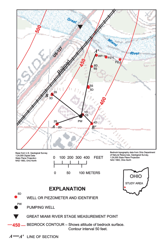
Previous studies have shown that ground-water flow is generally in the direction of surface-water flow (or parallel to the buried valley walls); but near a pumping well, flow is perpendicular to the main axis of the Great Miami River with a component of downvalley flow (Klaer and Thompson, 1948; CH2M-HILL, 1992; Sheets and others, 2002). With these flow patterns in mind, the USGS drilled 10 borings at the Hamilton North Well Field during October 6–20, 2002, using a 6-in. hollow-stem auger. The layout of the borings, as much as logistically feasible, was perpendicular and parallel to the main axis of the Great Miami River. Auger material was described by an onsite geologist or the driller. Split-spoon samples were collected approximately every 5 ft for each boring. The deep borings were drilled to refusal. Two-inch monitoring wells were installed at each boring site (fig. 2). Four shallow/deep well pairs were completed for monitoring of vertical gradients at the well field. It was not possible to complete boring 6D as a well. Well information and boring characteristics, including location and depth and length of screen (table 1), were entered into the USGS National Water Information System, Ground-water Site Inventory database. (Lithology and results of grain-size analyses are included in Appendix 1.)
Two 1-in. piezometers, PZ-1 and PZ-2, were installed in the river within several feet of the bank (fig. 2) to measure hydraulic gradient between the river and the shallow ground water. The piezometers were driven into the streambed and developed with surging. The 6-in.-long piezometer screens were placed approximately 2.1 ft and 3.8 ft below the streambed (PZ-1 and PZ-2, respectively). A third piezometer, WP-11, was installed near the river prior to the study by the Hamilton to New Baltimore Ground Water Consortium. This piezometer was driven to approximately 5 ft below the streambed. The screen length is unknown. The water level in this piezometer was measured during the course of this investigation.
Grain-size analyses were done on 22 of the split-spoon samples taken from some of the borings. The samples were selected on the basis of the vertical depths within the borings. After each sample was dried and weighed, it was placed in a vibrating sieve shaker. Stainless-steel sieves were used to separate the samples into different size fractions, which were then classified according to size; opening sizes were 0.063, 0.125, 0.149, 0.212, 0.5, 1, 2, and 4 mm. The samples for each size fraction were weighed, the resulting data were plotted, and subsequent analyses determined D10, D50, and hydraulic conductivity (Hazen, 1911). The D10 is the grain size (in millimeters) at which 10 percent by weight of the sample has been retained and 90 percent of the sample has passed. Similarly, the D50 is the grain size at which 50 percent by weight of the sample is retained. The Hazen approximation was used to estimate bulk hydraulic conductivity where the D10 was between 0.1 and 0.3 mm (Hazen, 1911; Fetter, 1994):
K=C(D10)2 (1)
where K is bulk hydraulic conductivity (centimeters per second) and C is a coefficient assigned to the sample based on the characteristics of the D 10 (centimeters).
The following shows values for the coefficient C (Fetter, 1994):
Very fine sand, poorly sorted 40–80
Fine sand with appreciable fines 40–80
Medium sand, well-sorted 80–120
Coarse sand, poorly sorted 80–120
Coarse sand, well sorted, clean 120–150
Table 1. Boring and well information for Hamilton North Well Field aquifer study.
[bls, below land surfuce]
| Local boring number | Site identification number | Boring depth (feet bls) | Altitude, top of casing (feet) | Well diameter (inches) | Well depth (feet bls) | Screened interval (feet bls) | |
|---|---|---|---|---|---|---|---|
| Top | Bottom | ||||||
| 1S | 392519084322400 | 43.0 | 591.13 | 2 | 35.5 | 24.0 | 34.0 |
| 1D | 392519084322401 | 70.5 | 590.86 | 2 | 70.5 | 64.0 | 69.0 |
| 2S | 392518084322800 | 40.5 | 591.82 | 2 | 40.5 | 34.0 | 39.0 |
| 2D | 392518084322801 | 54.0 | 591.42 | 2 | 52.0 | 44.5 | 49.5 |
| 3S | 392522084322900 | 49.0 | 588.89 | 2 | 41.86 | 30.36 | 40.36 |
| 3D | 392522084322901 | 75.15 | 588.63 | 2 | 75.15 | 68.65 | 73.65 |
| 4D | 392518084322300 | 71.3 | 591.41 | 2 | 71.3 | 64.8 | 69.8 |
| 5S | 392523084322400 | 29.84 | 590.74 | 2 | 29.84 | 23.34 | 28.34 |
| 5D | 392523084322401 | 64.95 | 589.65 | 2 | 64.95 | 58.45 | 63.45 |
| 6S | 392525084322300 | 28.81 | 588.07 | 2 | 28.81 | 17.31 | 27.31 |
| 6D | __ | 68.0 | __ | __ | __ | __ | __ |
| PW | 392519084322500 | 138.21 | 592.45 | 18 | 134.92 | 87.92 | 134.92 |
A multiple-well aquifer test was done April 7–11, 2003, by pumping a production well in the Hamilton North Well Field. All other production wells at the Hamilton North Well Field were turned off about 1 month before the study and were not pumping for the period of study. Pressure transducers installed in the monitoring wells recorded water levels prior to, during, and after the aquifer test. A pressure transducer also was installed by the Hamilton to New Baltimore Ground Water Consortium in a monitoring well, HNC-1D, approximately 8 mi north of the Hamilton North Well Field (fig. 1); these data were collected from March 13 until April 30, 2003. Periodic manual water-level measurements were made with an electric measurement tape to verify the water levels recorded by the pressure transducers. Water levels also were measured by electric tape at the piezometers—water-level measurements of the river (outside of the piezometers) and inside the piezometers were made before, during, and after the aquifer test. Measurements of river stage also were made at a bridge on U.S. 127 (fig. 2) by use of a weighted steel tape. These measurements were made several times during the study and compared to measurements made at the USGS streamflow-gaging station Great Miami River at Hamilton (03274000) (fig. 1; Shindel and others, 2004).
All borings and other measurement sites were surveyed by use of standard differential Global Positioning System (GPS) procedures. A total station surveying instrument was used where it was not possible to receive satellite signals for the GPS instrument and for cross checks of the GPS instrument. The maximum error in measurements in latitude and longitude (spatially) is approximately 0.1 ft and in z (altitude), approximately 0.05 ft.
Hourly barometric pressure data for the same period as the water-level measurements were downloaded from the National Climatic Data Center (www.ncdc.noaa.gov) for the Butler County Regional Airport (station HAO; fig. 1). A barometric pressure rise and fall over a period of no pumping and static gage height in the Great Miami River (January 26–27 and February 20–21, 2003) was chosen to determine barometric efficiency (BE) (Todd, 1980):
BE=C*δH/δP (2)
where C is a conversion factor (0.833 in. Hg/ft H2O) and δH is change in water level (feet) due to δP, a change in barometric pressure (inches Hg).
Commercially available software, AQTESOLV (HydroSOLVE Inc., 1997), was used for the analysis of the aquifer-test data to determine aquifer hydraulic properties and to determine whether local clay units act as barriers to downward flow to pumping wells. Using this software, an analytical solution to flow in a confined, two-aquifer system (Neuman and Witherspoon, 1969) was tested for use on the data collected during this study. Assumptions for this solution are that the aquifer and confining unit have infinite areal extent and are homogeneous, isotropic, and of uniform thickness. Additional assumptions are that the pumping well fully penetrates the aquifer, that flow to the pumping well is horizontal, and that flow is released instantaneously from storage with decline of hydraulic head. AQTESOLV was also used to test an analytical solution for unsteady flow to a partially penetrating large-diameter well in an unconfined aquifer with delayed gravity response (Moench, 1997). Assumptions for this solution are that the unconfined aquifer has infinite areal extent, is homogeneous, and is uniform in thickness.
The geologic setting and lithology discussed in this section are important factors for determining areal recharge and permeability characteristics within buried-valley systems. Ground-water levels are indicative of local ground-water flow directions within the ground-water system; comparisons are made to the surface-water levels to examine surface-water/ground-water relations in the lower GMR-BVAS.
The bedrock underlying the lower Great Miami River valley consists of Ordovician interbedded limestone and shale. The bedrock was incised by glacially fed streams during the several glacial events of the Pleistocene era. The unconsolidated material deposited by the glacially fed streams consists of weakly stratified sand, silt, and gravel interspersed with some clay or till lenses. The till lenses are identified by the gray or blue color, hardness, dryness, and inclusion of gravel (Klaer and Thompson, 1948; Spieker, 1968). The till lenses were originally laid down as clay-rich layers during glacial recession; subsequent glacial advances and periglacial streams dissected these layers into discontinuous lenses. Outside the limits of the BVAS, glacial till caps the upland areas (Spieker, 1968). Well yields in the area are somewhat indicative of varying depositional environments and glacial material types (fig. 1) and generally correspond to Spieker's hydrogeologic environments (Spieker, 1968), which were based on variations in hydrology and geology, especially in terms of aquifer properties.
Driller's descriptions and split-spoon cores from the drilling program yielded valuable insight into the heterogeneity of the lower GMR-BVAS and information on grain-sizes and relative hydraulic conductivities at the Hamilton North Well Field (Appendix 1). Geologic cross sections derived from drillers' descriptions of borings through the north part of the well field are shown in figures 3 and 4. The sections show the discontinuous clay/till layers that are typical in the lower GMR-BVAS (CH2M-HILL, 1992). At the north end of the Hamilton North Well Field, boring 5D (fig. 2) intersected a significant clay layer from 24 to 53 ft (Appendix 1); boring 6D, which is approximately 200 ft from the Great Miami River, also intersected clay at 24 ft, which continued to the bottom of the boring at 74 ft. Boring 4D contains a thin clay layer from 24 to 26 ft. Borings 1S and 1D (fig. 2) had clay only near the top of the borings (about 2–10 ft below land surface), but silt and sand was found in 1D from 45 to 69 ft. Borings 2S and 2D illustrate the variable nature of the aquifer material over very short lateral distances (< 10 ft)—boring 2D had clay or clay and gravel with variable wetness from a depth of approximately 26 ft to 44 ft; in boring 2S, clay and gravel were found only from 25 to 28.5 ft with little or no clay and saturation to 41 ft. (The same geologist logged both borings.) Lithologic descriptions were available only for the screened interval of the production well PW (figs. 3 and 4).
Grain-size analyses show the variability of the aquifer material and of the units that may act locally as confining units. For aquifer materials described, the median D10 grain size (described by driller's descriptions that do not include "clay") was 0.12 mm, with a standard deviation (s) of 0.17. The median D50 of the same material was 1.3 mm (s=2.5). For locally confining units including "clay" in the lithologic descriptions, the median D10 was 0.04 mm (s=0.3); the median D50 was an order of magnitude less than that of the aquifer material—0.1 mm (s=0.7).
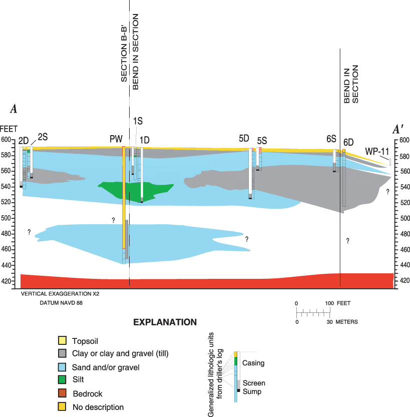

Recharge to the lower GMR-BVAS is primarily through either areal distribution of precipitation or infiltration through the banks and bottom of the Great Miami River and its tributaries (Klaer and Thompson, 1948; Spieker, 1968; CH2M-HILL, 1992; Sheets and others, 2002). Areal recharge to the ground-water system varies spatially with soil type and surficial geology. Generally, areal recharge estimates for the lower GMR-BVAS are similar to those in the upper GMR-BVAS, the probable range being from 4 in/yr in the upland areas where glacial till lies at the surface to as much as 15 in/yr in the central part of the lower GMR-BVAS (Dumouchelle, 1998). A near-surface clay layer underlies the north part of Hamilton North Well Field (figs. 3 and 4), but it does not extend laterally and may not inhibit areal recharge.
Infiltration from streams occurs where the hydraulic head in the stream is higher than the hydraulic head in the aquifer; for example, during high flow in streams (resulting in what may be referred to as "bank storage") or when the hydraulic head in the aquifer is artificially lowered by pumping (resulting in induced infiltration or bank filtration). Head in the aquifer also can be naturally lower than head in the stream. This condition is common where small streams cross over the boundary of the uplands BVAS and where the streams lose water to the aquifer because of the much higher permeability aquifer materials of the BVAS than of the upland. Natural losses from the larger streams in the central part of the valley are rare, because the major streams usually are the regional ground-water discharge areas for the BVAS. Near the Hamilton North Well Field, a thick (>20 ft) clay layer was found at boring 6D (fig. 3). This clay layer may extend under the Great Miami River; borings directly across the Great Miami River from the Hamilton North Well Field also indicate a clay layer at about 30 ft below land surface (altitude about 570 ft; C. Randy Bishop, ENSR International, written commun., 2004). Generally, the clay/till layers in this part of the lower GMR-BVAS do not appear to be laterally continuous (fig. 3), but the thickness of the clay layer at boring 6D and its presence across from the well field may indicate that flow from the Great Miami River to production wells is somewhat restricted.
Most of the ground water within the GMR-BVAS is from recharge. A small amount of ground water enters or leaves the GMR-BVAS through the underlying bedrock. The permeability of the bedrock is usually assumed to be at least 2 orders of magnitude lower than that of the GMR-BVAS, but the upper few feet of the bedrock is assumed to be more permeable because of weathering (Dumouchelle and others, 1993; U.S. Department of Energy, 1995). Because of the low permeability of the Ordovician bedrock, it is seldom used for water supplies, so water-level data for the bedrock uplands are scarce. Water levels in the upper bedrock probably mimic water levels in the till covering the bedrock and ground-water flow from the upper bedrock probably is toward the lower GMR-BVAS. Ground-water flow within the bedrock usually is not considered an important component of flow within the lower GMR-BVAS, but discharging wells near the BVAS and bedrock contact may be affected by induced flow from bedrock. Water quality in the Ordovician bedrock generally is considered poor because of high sodium and chloride concentrations (Sheets and others, 1994).
Ground-water levels in the GMR-BVAS were measured from October 2002 through July 2003 in the wells completed to determine the direction of ground-water flow for this study. In figures 5 and 6, long-term water-level elevations in shallow and deep wells are compared to the water level elevation in the Great Miami River. Water-level elevation for the river was calculated by means of linear regression (r2=0.99) of the gage height at the river at Hamilton (USGS streamflow-gaging station 03274000) and about 20 manual measurements of water levels during the course of the study at the U.S. 127 bridge just north of the Hamilton North Well Field (Appendix 2; Shindel and others, 2004). The shallow and deep wells show similar trends relative to the Great Miami River—from October to mid-November 2002, water levels from all wells were recovering, probably because of reduced pumping at the Hamilton North Well Field. After mid-November 2002, water-level fluctuations in the Great Miami River from rainfall/runoff were transmitted to each of the monitoring wells, both shallow and deep. Periodic pumping in the well field in December 2002 and January 2003, and then again after March 2003, caused sharp declines in the ground-water hydrographs (figs. 5 and 6).
Water-level elevations in the piezometers generally
mimicked water-level elevations in the Great Miami River, especially during March through April 2003 (fig. 5; Appendix 2). Water-level gradients between the piezometers and the river were not conclusive in terms of defining a losing or gaining stream reach and may have been due to areas of reduced streambed permeability, improper placement of piezometers, or frequency of data collection (Appendix 2). Water-level elevations for HNC-1D, about 8 mi north of Hamilton North Well Field (fig. 1), also are shown on figure 6. These water levels showed a general decline during the period, corresponding to a decline in Great Miami River levels.
During periods of no pumping and between rises in the Great Miami River water levels, water-level elevation in each monitoring well is above water-level elevation in the river (fig. 5)—indicating that under these conditions, at least, local ground water is discharging to the Great Miami River. Water-level configurations are shown in figure 7a for the shallow and deep well pairs during a period of no pumping, when the stream stage is relatively static (February 2003). Water levels in the shallower part of the aquifer indicated that, in the shallowest part of the aquifer within 500 ft of the Great Miami River, ground-water flow was toward the river. At distances greater than 500 ft from the river, shallow ground-water flow was away from the river. Water levels for the deeper wells indicate that ground-water flow was away from the river (fig. 7a). Horizontal hydraulic gradients during periods of no pumping and relatively low stream stage were small (≈0.0005 ft/ft). After the onset of water-level rises in the river, however, water levels in the wells were lower than river levels, indicating stream loss to the aquifer. In figure 7b, water-level configurations are shown for the shallow and deep well pairs during a period of no pumping and a stream-stage peak (January 2003). Ground-water flow was away from the river for both sets of wells, and the horizontal hydraulic gradient was much higher than when stream stage was relatively low (≈0.001 ft/ft).
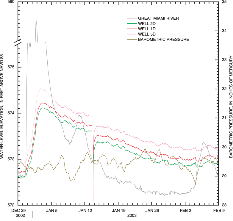
Examination of water levels during a stream-stage recession revealed additional aspects of the stream/aquifer interaction in this area of the lower GMR-BVAS. Water levels in shallow and deep monitoring wells along a potential flow path to and from the river (cross section A-A', fig. 3) are shown in figures 8 and 9. At a peak of the stream hydrograph during a runoff event in early January 2003, water levels in the stream were higher than each successive water level in wells along a potential shallow and deep flow path (fig. 8, Great Miami River >6S>5S>1S>2S; or fig. 9, Great Miami River >5D>1D>2D). For example, as the water level in the river receded and dropped lower than water levels in the shallow wells (fig. 8), the water level in well 6S, closest to the river, fell below that of 5S and neared the water level in 1S before river stage increased again on February 5, 2003. The difference in the water levels between shallow monitoring wells also got smaller as the river stage receded, indicating that equilibrium between the Great Miami River and the shallow aquifer was not reached between the two increases in stage. An examination of the water-level records for the period (figs. 5 and 6) indicated that either pumping or runoff prevented the aquifer from reaching equilibrium with the Great Miami River during the measurement period. The deeper wells do not show such a marked response in the short-term hydrograph (fig. 9); but over a longer period (fig. 6), water levels and hydraulic gradients acted much the same way as in the shallower aquifer. This complex cycle of gains and losses to the aquifer from the Great Miami River indicates that some type of bank storage was an active process in this part of the lower GMR-BVAS.
Influences on ground-water levels in addition to stream stage may include barometric pressure, earth tides, and potentially transient pressure on the aquifer from passing trains. As barometric pressure falls, and atmospheric pressure on a confined or semiconfined aquifer decreases, water levels in wells completed in these aquifers rise; as barometric pressure rises, water levels fall (Freeze and Cherry, 1979). Water levels in wells completed in unconfined aquifers are not typically affected by changes in atmospheric pressure because the atmospheric pressure is transmitted directly to the water table in the aquifer and the well. Barometric pressure is shown in figures 5, 6, 8, and 9; the deep monitoring wells and well 2S show an indication of an inverse correlation between barometric pressure and water level. The screen in well 2S lies immediately beneath a clay unit found during borehole drilling. The water levels in wells 1S, 5S, and 6S show little effect from barometric pressure. A regression analysis between water levels in the monitoring wells and barometric pressure during a period of nonpumping was done, and barometric efficiencies ranged from 6 to 20 percent (6S and 2S, respectively); however, the effect of stage changes in the Great Miami River on water levels in the wells complicated the analysis. The range of barometric efficiency for confined aquifers usually is in the range of 20 to 75 percent (Freeze and Cherry, 1979).
Another possible influence on water levels in wells of the lower GMR-BVAS is earth tides effects (Todd, 1980; Ritzi and others, 1991). Earth tides are due to the Earth's attraction to the moon and sun and occur at diurnal and semidiurnal cycles. An amplitude spectrum analysis of water levels in the BVAS indicates that the tidal component for the monitoring wells, if present, is obscured by the atmospheric component (barometric pressure). A shallow, unconfined or semiconfined aquifer usually does not exhibit earth-tide effects unless the saturated thickness is large and porosity is very low (Bredehoft, 1967).
The Hamilton North Well Field is next to a heavily used railroad that also could potentially affect water levels at the well field (fig. 2). External loads can affect confined aquifers by compressing the aquifer and increasing the hydrostatic pressure (Todd, 1980). The lateral discontinuity of confining units may decrease this effect, but it may be important locally. Water levels in monitoring wells used for this study were not obviously affected by railway traffic, based on either hourly measurements or more frequent data collection during the aquifer test (a measurement every second).

Hydraulic properties of the aquifer at the Hamilton North Well Field were estimated by use of (1) grain-size analyses of samples collected from borings, and (2) a multiple-well aquifer test at the well field in April 2003. The results of these studies are given in the paragraphs that follow.
Estimated bulk hydraulic conductivity for selected core samples, based on grain-size analyses and the use of the Hazen equation (Hazen, 1911), ranged from 25 to 1,200 ft/d (Appendix 1). The method is generally only applicable to sands with an effective grain size (D10) between 0.1 and 3.0 mm (Fetter, 1994). The arithmetic and geometric means of bulk hydraulic conductivities of the aquifer material at the Hamilton North Well Field, based on these criteria, are approximately 240 ft/d and 89 ft/d, respectively.
An existing production well (PW, fig. 2) was pumped for approximately 94 hours during April 7–11, 2003, at an average rate of 2,830 gal/min; the pumping rates during this period varied between 2,700 and 3,000 gal/min. Water levels were monitored by use of transducers and hand measurements during this period, with more frequent data collection (approximately 1 reading per second) at the beginning of pumping. Recovery of water levels was also monitored after cessation of pumping. Water-level configurations for the shallow and deep well pairs near the end of pumping are shown in figure 7c and 7d. Water levels from the shallow wells in each pair (fig. 7c) and shallow flow gradients (≈0.003 ft/ft) indicate that shallow ground-water flow is away from the river and toward the production well; a small water-level depression is found just south of the production well (fig 7c). Water levels from the deeper well in each well pair (fig. 7d) show a marked water-level depression around the production well. The configuration of the water levels for the shallow and deeper parts of the aquifer indicates horizontal flow from the river in the upper part of the aquifer (on top of the clay layer found in boring 6D), toward the production well. As this horizontal flow reaches leaky (silty) areas or holes in the clay confining unit, vertical flow becomes dominant.
The water levels measured during pumping were converted to drawdown (static water-level elevation prior to pumping minus water-level elevation during pumping). During the course of the aquifer test, barometric pressure changed approximately 0.33 in. Hg; this corresponds to a maximum barometrically induced change of water level of about 0.07 ft (from well 2S), on the basis of a barometric efficiency of 20 percent. The maximum change of water level because of pumping and barometric pressure changes was about 3.1 ft, corresponding to a maximum barometric pressure effect of less than 2.5 percent. For this reason, water levels were not corrected for barometric pressure. Water levels in wells also were not corrected for earth tides and loading from passing trains.
Because water levels in the aquifer respond to rises and falls in the river stage, it is likely that water levels in the aquifer were generally declining during the aquifer test because of a recession of the river (figs. 5, 6). The water levels in each of the observation wells were corrected for this recession by use of linear interpolation between water levels just prior to the start of the aquifer test and water levels about 13 days after the start of the test (about 9 days after cessation of pumping). This is when minimal drawdown is expected because of the pumping during the aquifer test and the impending rise in the Great Miami River hydrograph. Although a linear interpolation may not match the recession of the ground-water hydrographs exactly, the errors are expected to be small relative to the total drawdown. The corrections ranged from 0.18 to 0.21 ft, ranging from 4 to 16 percent of the total drawdown at the monitoring wells.
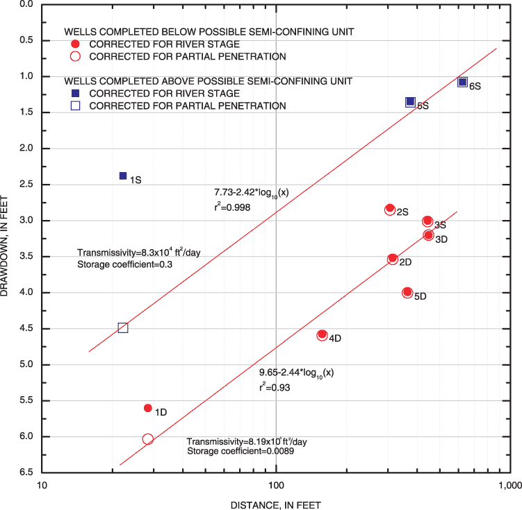
Because the monitoring wells and production well partially penetrate the aquifer system, drawdowns in the wells, especially those near the production well, are less than what would be expected if the wells were fully penetrating. Drawdown for monitoring wells was corrected by use of an approximation by Weeks (1969). The largest corrections were for wells 1S, 1D, 4D, 2S, 2D, and 5S (3.01, 1.60, 0.14, 0.05, 0.04, and 0.02 ft, respectively). The corrections for the remaining wells were 0.01 ft or less.
In figure 10, the maximum drawdown at approximately 3.92 days (94 hours) from the beginning of the aquifer test (corrected for river stage and partial penetration) is plotted against monitoring-well distance from the pumping well. The wells were classified as to whether they were completed above or below a clay or silt layer that may act as a semiconfining unit. The distance-drawdown plot and a closer inspection of the lithology indicate that a silty sand layer from 45 to 69 ft may be a local confining unit for well 1D (Appendix 1, fig. 1-1). Wells 2S and 2D are both completed immediately beneath a clay unit (fig. 3); wells 3S and 3D also are completed in similar horizons in the BVAS (fig. 4). The clustering of maximum drawdown for wells 2S, 2D, 3S and 3D suggests that they are all completed in similar horizons as 1D, 4D and 5D. The maximum drawdown of well 1S indicates that it is likely not completed in the same subunit of the BVAS that well 1D is completed in. Given the lithologic descriptions and the separation of maximum drawdown (fig. 10), the part of the aquifer in which wells 1S, 5S, and 6S is completed is at least partially separated from the part of the aquifer in which the other wells and the production well are completed. A conceptual model based on these results is that the upper part of the BVAS in this area is supplying water to a lower, semiconfined aquifer.
Linear regression was used to estimate transmissivity and the storage coefficient for each set of wells, based on the formulas by Cooper and Jacob (1946) and Jacob (1950):
T=C*Q/ΔS and (3)
S=D*T*t/r0 2 (4)
where T is transmissivity (feet squared per day)
C, D are coefficients that depend upon the units used
(0.367 and 2.24, respectively),
Q is discharge rate at pumping well (cubic feet per day)
ΔS is change in drawdown over one log cycle of distance
(feet),
S is storage coefficient,
t is time since pumping started (days), and
ro is intercept of extended straight line to zero drawdown
(feet).
For the wells completed below the semiconfining unit, the calculated transmissivity is 8.19x104 ft2/d, which, assuming an aquifer thickness of 150 ft, corresponds to a hydraulic conductivity of 546 ft/d. For the wells completed above the semiconfining unit, the calculated transmissivity is 8.30x104 ft2/d, corresponding to a hydraulic conductivity of 553 ft/d, also assuming an aquifer thickness of 150 ft. Storage coefficients for the wells below and above the semiconfining unit are 0.0089 and 0.3, respectively. These calculated transmissivities and storage coefficients are in the upper range for this type of glacial material.
A composite drawdown plot (fig. 11 A, B) can also be used to analyze drawdown data for this system to support or refute the conceptual model. Analytical solutions of drawdown in a confined two-aquifer system were developed by Neuman and Witherspoon (1969). Drawdown in wells 1D, 2D, 3D, 4D, and 5D, which are below the semiconfining unit, is shown in figure 11A. The best-fit Neuman and Witherspoon (1969) type curves also are shown. Because the Neuman and Witherspoon solutions do not account for partial penetration, drawdown for later times in well 1D are corrected for partial penetration, by means of a technique by Weeks (1969). The type curves shown are based on the transmissivities and storage coefficients of the lower and upper aquifer (T, T', S, S', respectively) and two dimensionless parameters (1/B and ß/r), that are functions of the distance of the observation well from the pumping well, thicknesses of the aquifers and confining units, and hydraulic conductivities of the lower and upper aquifers and the semiconfining unit. The small value of the dimensionless parameters (1/B and ß/r) indicates that downward leakage through the semiconfining unit may be considerable; as these parameters get smaller, the solution of Neuman and Witherspoon (1969) approaches that of the Theis (1935) solution. (See Theis type curve for 1D, fig. 11A.) However, as the dimensionless parameters get larger, composite drawdown curves show a delayed response, indicating that leakage through the semiconfining unit is less. The remaining wells completed beneath the semiconfining unit (2S and 3S) are shown in figure 11B, along with type curves shown for larger values of ß/r. Drawdown in the wells completed in the upper unconfined part of the aquifer (1S, 5S, and 6S; fig. 11B) shows what would be expected from pumping in a lower aquifer at least partly separated from the aquifer in which the wells are completed (Neuman and Witherspoon, 1969, p. 88). Drawdown is much less than what would be expected if they were completed in the same aquifer (figs. 10 and 11), and the response to pumping is muted and somewhat delayed.
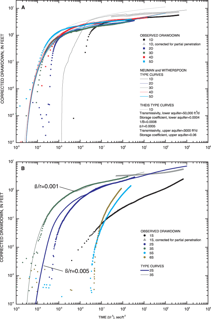
Using curve matching and the solutions of Neuman and Witherspoon (1969), the resultant T, K (based on aquifer thickness below the semiconfining unit of 110 ft), and S for the semiconfined aquifer are in a reasonable range, averaging 50,000 ft2/d, 450 ft/d, and 0.0005, respectively (fig. 11). The calculated hydraulic conductivities from the aquifer test are higher than those calculated from grain-size analyses and are at the high end of what can be expected for this type of glacial material. This difference is likely due to the scale effect of hydraulic conductivity, whereby the hydraulic conductivity depends on the scale of the tests conducted to determine the hydraulic properties and is proportional to the volume of material sampled (Neuman, 1990; Schulze-Makuch and others, 1999). An estimated hydraulic conductivity for the semiconfining unit (approximately 0.2 ft/d) and for the upper unconfined aquifer (200 ft/d, based on an assumed thickness of 15 ft) were also obtained by use of the Neuman-Witherspoon solution and are in a reasonable range for these materials.
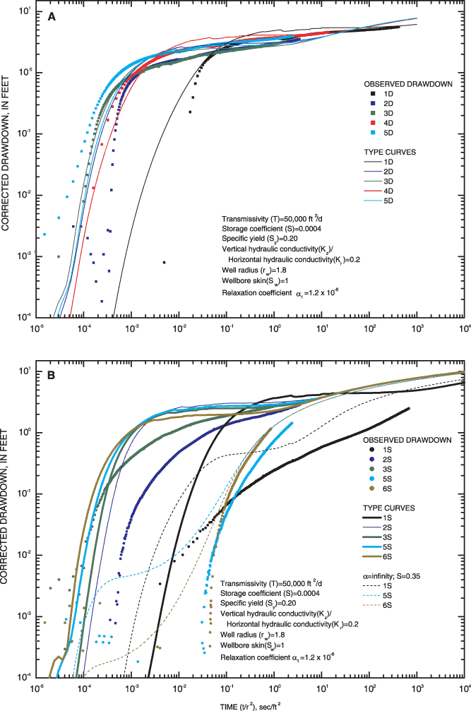
A second conceptual model can be examined by attempting to match other analytical solutions to the observed drawdown data. Because the semiconfining unit seems to be variably leaky and discontinuous, especially in the vicinity of the production well, the aquifer system may act as a single, unconfined aquifer. The Moench (1997) analytical solution can be used to test whether the aquifer system acts as an unconfined aquifer. Figure 12 shows the same composite drawdown data as figure 11, except that type curves for the Moench solution are shown. The Moench solution accounts for partial penetration, so the late-time drawdown data for well 1D are not corrected. For the deeper wells (fig. 12A), a reasonable match can be obtained between the observed data and Moench type curves, with the resulting hydraulic properties similar to those from the Neuman-Witherspoon (1969) solution: T=50,000 ft2/d, K=333 ft/d (based on unconfined aquifer thickness of 150 ft), S=0.0004, and specific yield =0.2. To obtain this match, the ratio of vertical hydraulic conductivity to horizontal hydraulic conductivity (Kz/Kr) equals 0.2, ostensibly meaning vertical ground-water flow is somewhat restricted, either from significant horizontal stratification of outwash sediments or the presence of less permeable sediments within the aquifer. The Moench solution also accounts for drainage of water from storage by means of the factor α1; the closer to zero α1 becomes, the more the upper-boundary value problem approaches that of a confined aquifer (Moench, 1997, p. 1399). To match the observed drawdown data with the Moench type curves, α1 was required to be 1.2 x 10⁻⁶, indicating that drainage from storage above the aquifer is limited or that the aquifer is confined or semiconfined.
Moench type curves and drawdowns from the other wells completed below the potential semiconfining unit (wells 2S and 3S) are shown in figure 12B. The Moench type curves do not match the drawdown data as well as the Neuman-Witherspoon type curves do (fig. 11B). This finding indicates that the aquifer system at Hamilton North Well Field can best be treated as a two-aquifer system, with a semiconfining unit separating an upper, unconfined aquifer and a lower, semiconfined aquifer.
The buried-valley aquifer at the Hamilton, Ohio, North Well Field consists primarily of unconsolidated sand and gravel, glacial outwash deposits. The sand and gravel aquifer is interspersed with variably discontinuous clay or silt layers that cause locally confined or semiconfined conditions.
A cooperative drilling and water-level monitoring program conducted by the USGS and the Hamilton to New Baltimore Ground Water Consortium at the Hamilton North Well Field provided information on the variable lithology of the aquifer and the effects of various external forces on water levels and flow directions in the aquifer. The grain-size analyses of aquifer sediments indicate that the D10 and D50 grain sizes of the clay-rich sediment are nearly an order of magnitude less than those of the aquifer material. Bulk hydraulic conductivities calculated from the grain-size analyses in the sand-size or greater part of the aquifer yielded a geometric mean of 89 ft/d and an average bulk hydraulic conductivity value of 240 ft/d.
Of all factors influencing static water levels in the aquifers, the stage of the Great Miami River has the greatest effect, indicating a connection between all parts of the aquifer and the river. Bank storage is an important hydrodynamic process in this aquifer system. External loading from barometric pressure affected water levels in deep monitoring wells and in a well screened beneath a clay unit but the effect of stage changes in the Great Miami River on water levels in the wells complicated the analysis.
A 94-hour aquifer test was done at the Hamilton North Well Field during April 7–11, 2003. The resultant drawdown was corrected for stream recession and plotted against distance and time. In this two-aquifer system, where the upper unconfined aquifer contributes flow to in the lower semiconfined aquifer, the transmissivity and storage coefficient for the semiconfined parts of the aquifer were calculated to be 50,000 ft2/d and 5x10⁻⁴, respectively. The average hydraulic conductivity (450 ft/d) based on the aquifer test is in a reasonable range for glacial outwash but is higher than calculated from grain-size analyses, indicating a scale effect. Hydraulic conductivities of the semiconfining unit and upper unconfined aquifer obtained by use of the Neuman-Witherspoon solution are about 0.2 ft/d and 200 ft/d, respectively.
The results of this study show that the part of the lower Great Miami River Buried Valley Aquifer System where the Hamilton North Well Field is located acts as a two-aquifer system. A discontinuity of the clay/till layers beneath the Great Miami River and the deeper parts of the aquifer system allow a direct response of water levels of the deep monitoring wells.
The authors thank Bruce Whitteberry (City of Cincinnati, Hamilton to New Baltimore Ground Water Consortium) for logistical assistance and discussions of ground-water hydrology in the lower GMR-BVAS. The authors also thank Tim McClellan (City of Hamilton) for logistical assistance at the well field.
Bredehoft, J.D., 1967, Response of well-aquifer systems to earth tides: Journal of Geophysical Research, v. 72, no. 12, p. 3075-3087.
CH2M-HILL, 1992, Wellhead protection area delineation report: Prepared for The Water Conservation District of The Miami Conservancy District, 39 p.
Cooper, H.H., and C.E., Jacob, 1946, A generalized graphical method for evaluating formation constants and summarizing well field history: American Geophysical Union Transactions, v. 27, p. 526–534.
Debrewer, L.M., Rowe, G.L., Reutter, D.C., Moore, R.C., Hambrook, J.A., and Baker, N.T., 2000, Environmental setting and effects on water quality in the Great and Little Miami River Basins, Ohio and Indiana: U.S. Geological Survey Water-Resources Investigations Report 99–4201, 98 p.
Dove, G.D., 1961, A hydrologic study of the valley-fill deposits in the Venice area (Butler County), Ohio: Ohio Department of Natural Resources, Division of Water Technical Report 4, 82 p.
Dumouchelle, D.H., Schalk, C.W., Rowe, G.L., and de Roche, J.T., 1993, Hydrogeology, simulated ground-water flow, and ground-water quality, Wright-Patterson Air Force Base, Ohio: U.S. Geological Survey Water-Resources Investigations Report 93–4047, 160 p.
Dumouchelle, D.H., 1998, Simulation of ground-water flow, Dayton area, southwestern Ohio: U.S. Geological Survey Water-Resources Investigations Report 98–4048, 57 p., 1 pl.
Fenneman, N.M., 1938, Physiography of Eastern United States: New York, McGraw-Hill, p. 449–536.
Fetter, C.W., 1994, Applied hydrogeology: Englewood Cliffs, N.J., Prentice-Hall, 691 p.
Freeze, R.A., and Cherry, J.A., 1979, Groundwater: Englewood Cliffs, N.J., Prentice-Hall, 618 p.
Harstine, L.J., 1991, Hydrologic atlas for Ohio—Average annual precipitation, temperature, streamflow, and water loss for the 50 year period 1931–1980: Ohio Department of Natural Resources, Division of Water, Water Inventory Report 28, 13 p.
Hazen, A., 1911, Discussion—Dams on sand foundations: in Transactions, American Society of Civil Engineers, v. 73, p. 199.
HydroSOLVE Inc., 1997, AQTESOLVTM for Windows—User's guide: Reston, Va. HydroSOLVE, Inc., 185 p.
Jacob, C.E., 1950, Flow of groundwater, in Rouse, H., ed. Engineering hydraulics; New York, John Wiley, p. 321–385.
Klaer, F.H. Jr., and Thompson, D.G., 1948, Ground-water resources of the Cincinnati area, Butler and Hamilton Counties, Ohio: U.S. Geological Survey Water-Supply Paper 999, 168 p.
Leow, J.A., Vorbau, K.E., and Bruce, B.R., 1998, Bedrock topography of Hamilton, Ohio quadrangle: Ohio Division of Geological Survey, Open-File Map, scale 1:24,000.
National Oceanic and Atmospheric Administration, 2004, National Climatic Data Center, Unedited climatological data for station HAO, October 2001 to June 2003: National Oceanic and Atmospheric Administration, accessed on June 17, 2003, at http://nndc.noaa.gov/index.shtml
Neuman, S.P., and Witherspoon, P.A., 1969, Theory of flow in a confined two aquifer system: Water Resources Research, v. 5, no. 4, p. 803–816.
Neuman, S.P., 1990, Universal scaling of hydraulic conductivities and dispersitivities in geologic media: Water Resources Research, v. 26, no. 8, p. 1749–1758.
Pruel, H.C., 1965, Report on effects of river water quality on well supplies of the Southwestern Ohio Water Company: Consulting report prepared for The Southwestern Ohio Water Company, 54 p.
Ritzi, W.R., Sorooshian, S., and Hsieh, P.A., 1991, The estimation of fluid flow properties from the response of water levels in wells to the combined atmospheric and earth tide forces: Water Resources Research, v. 27, no. 5, p. 883–893.
Schulze-Makuch, D., Carlson, D.A., Cherkauer, D.S., and Malik, P., 1999, Scale dependency of hydraulic conductivity in heterogeneous media: Ground Water, v. 37, no, 6., p. 904–919.
Sheets, R.A., Darner, R.A., and Whitteberry, B.L., 2002, Lag times of bank infiltration at a well field, Cincinnati, Ohio, USA: Journal of Hydrology, v. 266, p. 162–174.
Sheets, R.A., and Yost, W.P., 1994, Ground-water contribution from the Silurian/Devonian carbonate aquifer to the Mad River Valley, southwestern Ohio: Ohio Journal of Science, v. 94, no. 5, p. 138–146.
Shindel, H.L., Mangus, J.P., and Frum, S.R., 2004, Water resources data, Ohio, water year 2003—Volume 1, Ohio River Basin excluding project data: U.S. Geological Survey Water-Data Report OH–04–1, 295 p.
Spahr, P.N., 1999, Unconsolidated aquifers of Ohio: Ohio Department of Natural Resources, Division of Water, Open-File Map, scale variable.
Spieker, A.M., 1968, Ground-water hydrology and geology of the Lower Great Miami River Valley, Ohio: U.S. Geological Survey Professional Paper 605–A, 37 p.
Theis, C.V., 1935, The relation between the lowering of the piezometric surface and the rate and duration of discharge of a well using ground-water storage: Transactions, American Geophysical Union, v. 2, p. 519–524.
Todd, D.K., 1980, Groundwater hydrology: New York, John Wiley & Sons, 539 p.
U.S. Department of Energy, 1995, Operable Unit Nine–Determination of potential pathways from source areas adjacent and within the buried valley aquifer via ground-water flow modeling and particle tracking: Prepared by Terran Corporation for EG&G Mound Applied Technologies [variously paginated].
U.S. Environmental Protection Agency, 2004, Designated sole source aquifers in Region V, accessed April 13, 2004, at http://www.epa.gov/safewater/swp/ssa/reg5.html
Walton, W.C., Hills, D.L., and Grundeen, G.M., 1967, Recharge from induced streambed infiltration under varying groundwater-level and stream-stage conditions: Minneapolis, Minnesota Water Resources Research Center, Bulletin 6, 43 p.
Ward, D.S., Buss, D.R., Mercer, J.W., and Hughes, S.S., 1987, Evaluation of a groundwater corrective action at the Chem-Dyne Hazardous Waste Site using a telescopic mesh refinement modeling approach: Water Resources Research, v. 23, no. 4, p. 603–617.
Weeks, E.P., 1969, Determining the ratio of horizontal to vertical permeability by aquifer-test analysis: Water Resources Research, v. 5, no. 1, p. 196–214.
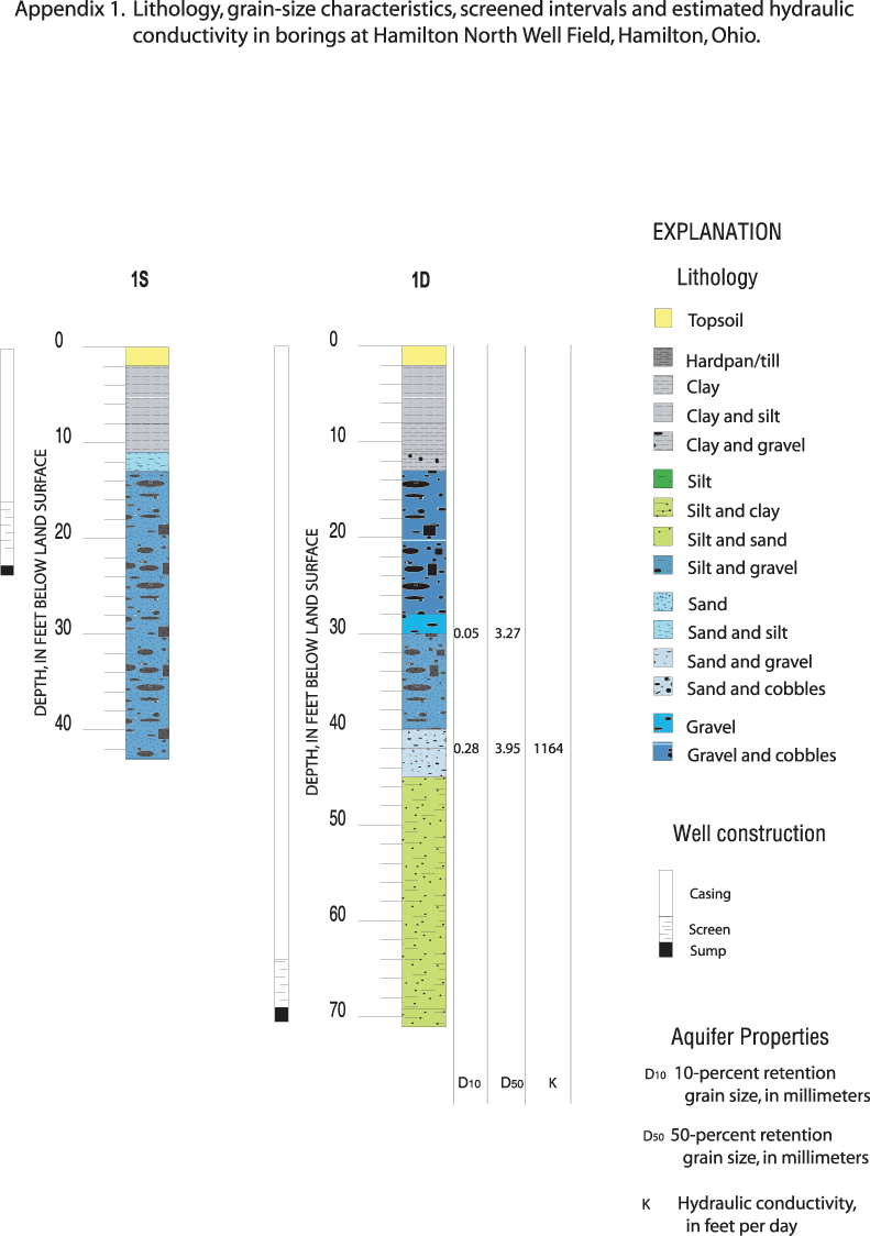
Figure 1-1. Description of lithology and results of grain-size analyses for wells 1S and 1D.
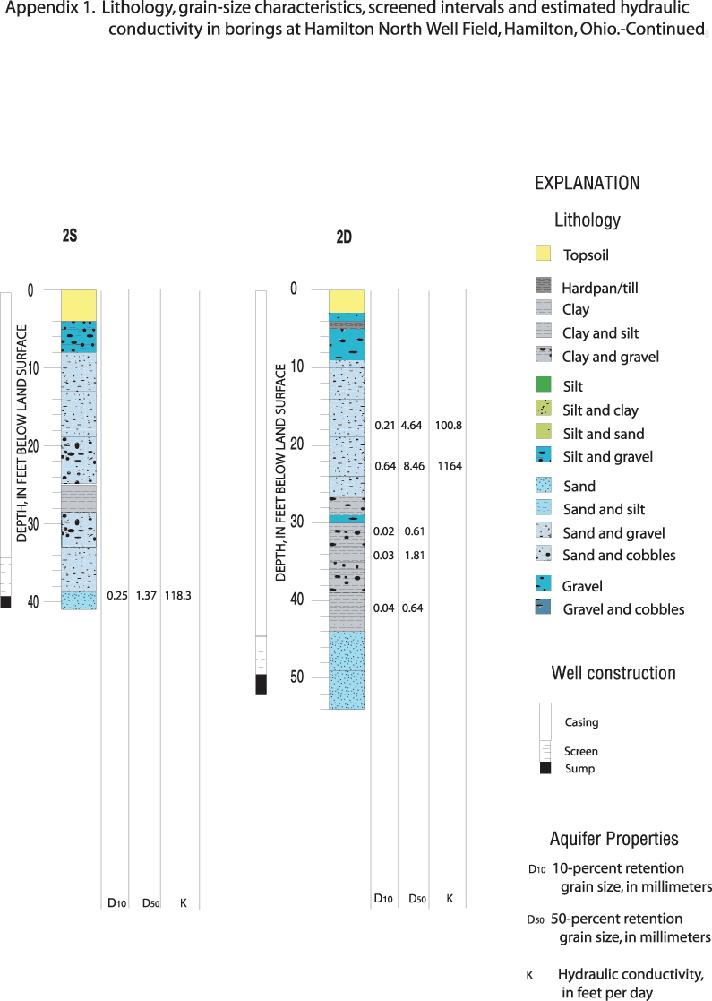
Figure 1-2. Description of lithology and results of grain-size analyses for wells 2S and 2D.
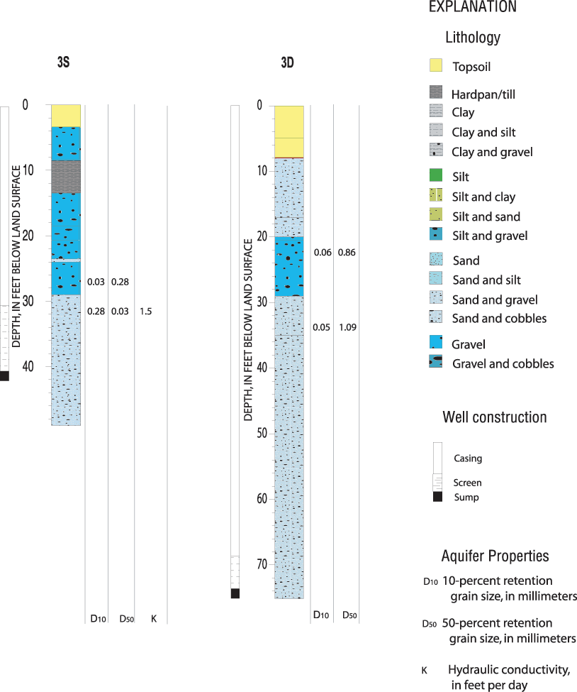
Figure 1-3. Description of lithology and results of grain-size analyses for wells 3S and 3D.
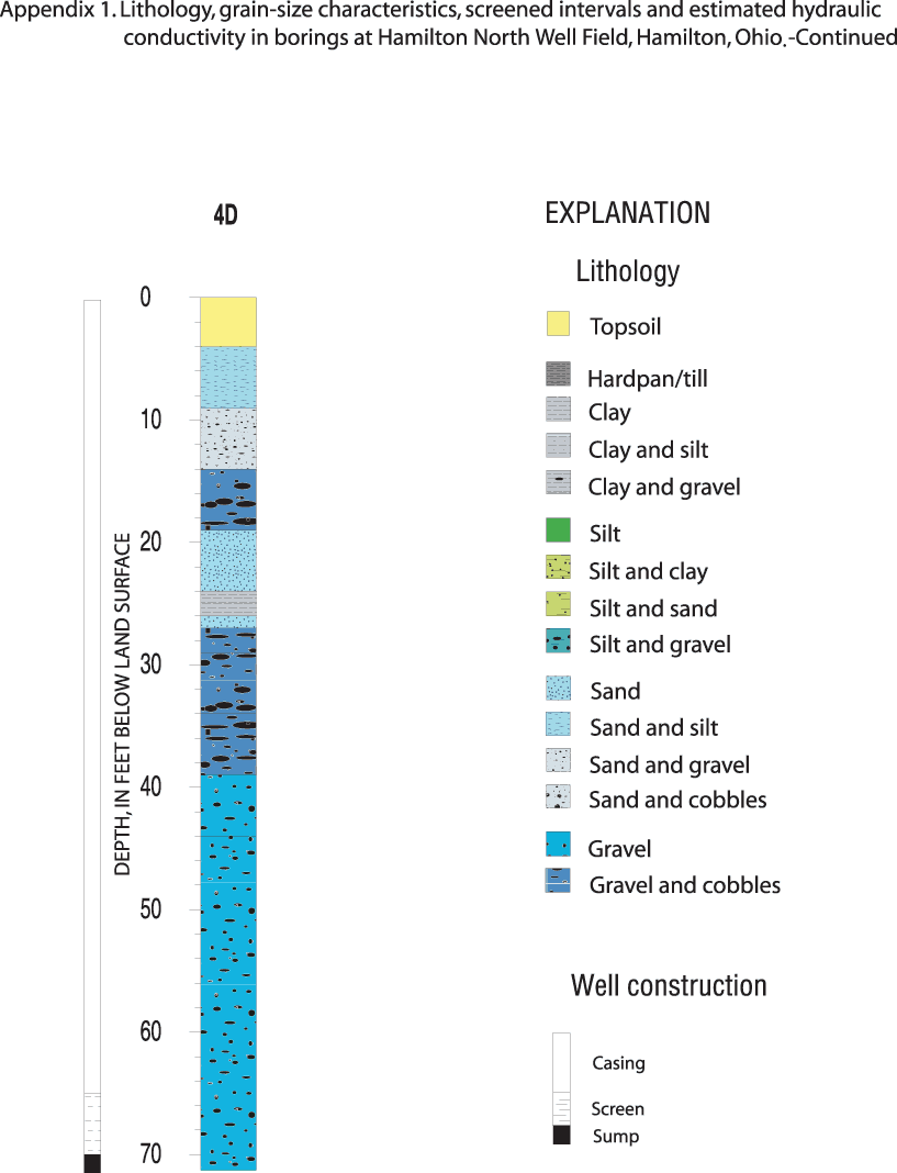
Figure 1-4. Description of lithology for well 4D.
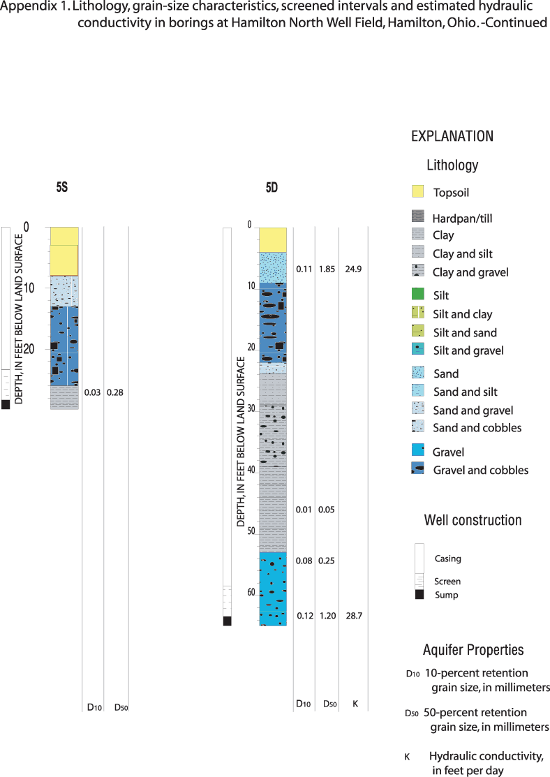
Figure 1-5. Description of lithology and results of grain-size analyses for wells 5S and 5D.
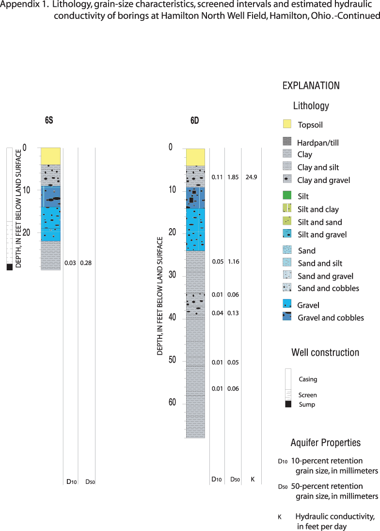
Figure 1-6. Description of lithology and results of grain-size analyses for well 6S and boring 6D.
| Site ID | Local name | Measuring-point elevation | ||
|---|---|---|---|---|
| 392526084322100 | PZ-1 | 575.024 | ||
| Date and time | Water-level elevation in piezometer | Water-level elevation outside piezometer (ft) | Difference in water-level elevation (ft) | |
| 12/23/2002 17:00 | 571.67 | 571.66 | 0.01 | |
| 1/28/2003 17:00 | 572.36 | 572.34 | 0.02 | |
| 2/18/2003 16:25 | 572.4 | 572.38 | 0.02 | |
| 3/20/2003 18:57 | 574.81 | 574.6 | 0.21 | |
| 3/25/2003 15:26 | 574.56 | 573.81 | 0.75 | |
| 3/25/2003 18:11 | 574.4 | 573.74 | 0.66 | |
| 3/25/2003 19:57 | 574.36 | 573.72 | 0.64 | |
| 3/26/2003 17:58 | 574.24 | 574.32 | -0.08 | |
| 3/26/2003 19:42 | 574.24 | 574.26 | -0.02 | |
| 3/27/2003 17:05 | 574.31 | 574.41 | -0.1 | |
| 3/27/2003 19:48 | 574.32 | 574.38 | -0.06 | |
| 4/7/2003 14:40 | 574.79 | 574.24 | 0.55 | |
| 4/7/2003 17:18 | 574.72 | 574.6 | 0.12 | |
| 4/7/2003 19:52 | 574.68 | 574.83 | -0.15 | |
| 4/8/2003 17:11 | 574.63 | 574.62 | 0.01 | |
| 4/8/2003 18:27 | 574.65 | 574.7 | -0.05 | |
| 4/9/2003 17:12 | 574.63 | 574.54 | 0.09 | |
| 4/10/2003 17:24 | 574.31 | 574.02 | 0.29 | |
| 4/11/2003 15:19 | 574.03 | 573.71 | 0.32 | |
| 4/11/2003 17:21 | 573.98 | 573.68 | 0.3 | |
| 4/11/2003 18:51 | 573.96 | 573.66 | 0.3 | |
| 4/14/2003 16:38 | 573.44 | 573.04 | 0.4 | |
| 4/14/2003 18:47 | 573.44 | 573.04 | 0.4 | |
| 4/17/2003 17:32 | 573.16 | 572.78 | 0.38 | |
| 5/27/2003 16:45 | 573.36 | 572.86 | 0.5 | |
| Site ID | Local name | Measuring-point elevation | ||
| 392526084321900 | PZ-2 | 576.083 | ||
| Date and time | Water-level elevation in piezometer | Water-level elevation outside piezometer | Difference in water-level elevation (ft) | |
| 12/23/2002 17:00 | 572.48 | 572.54 | -0.06 | |
| 1/28/2003 17:00 | 571.45 | 571.45 | 0 | |
| 2/18/2003 17:00 | 571.49 | 571.49 | 0 | |
| 3/25/2003 15:29 | 572.92 | 572.8 | 0.12 | |
| 3/25/2003 18:14 | 572.89 | 572.77 | 0.12 | |
| 3/25/2003 20:00 | 572.85 | 572.74 | 0.11 | |
| 3/26/2003 18:03 | 573.41 | 573.32 | 0.09 | |
| 3/27/2003 17:08 | 573.54 | 573.43 | 0.11 | |
| 3/27/2003 19:51 | 573.5 | 573.39 | 0.11 | |
| 4/7/2003 14:51 | 573.34 | 573.27 | 0.07 | |
| 4/10/2003 17:36 | 574.29 | 574.17 | 0.12 | |
| 4/11/2003 15:24 | 574 | 573.9 | 0.1 | |
| 4/11/2003 17:28 | 573.96 | 573.86 | 0.1 | |
| 4/11/2003 18:58 | 573.95 | 573.88 | 0.07 | |
| 4/14/2003 16:43 | 573.34 | 573.29 | 0.05 | |
| 4/14/2003 18:51 | 573.33 | 573.28 | 0.05 | |
| 4/17/2003 17:34 | 573.07 | 573.04 | 0.03 | |
| 5/27/2003 16:51 | 573.21 | 573.19 | 0.02 | |
| Site ID | Local name | Measuring-point elevation | ||
| 392526084322200 | WP-11 | 576.263 | ||
| Date and time | Water-level elevation in piezometer | Water-level elevation outside piezometer | Difference in water-Level elevation (ft) | |
| 1/28/2003 17:00 | 572.65 | 572.56 | 0.09 | |
| 2/18/2003 17:00 | 572.63 | 572.63 | 0. | |
| 3/17/2003 15:37 | 576.14 | 576.14 | 0. | |
| 3/17/2003 19:03 | 576.08 | 576.08 | 0. | |
| 3/17/2003 20:12 | 576.04 | 576.04 | 0. | |
| 3/18/2003 16:48 | 575.54 | 575.5 | 0.04 | |
| 3/18/2003 19:19 | 575.47 | 575.41 | 0.06 | |
| 3/20/2003 18:54 | 574.93 | 574.87 | 0.06 | |
| 3/25/2003 15:23 | 574.19 | 574.04 | 0.15 | |
| 3/25/2003 18:07 | 574.15 | 574 | 0.15 | |
| 3/25/2003 19:53 | 574.11 | 573.97 | 0.14 | |
| 3/26/2003 17:51 | 574.65 | 574.59 | 0.06 | |
| 3/26/2003 19:40 | 574.59 | 574.52 | 0.07 | |
| 3/27/2003 17:02 | 574.73 | 574.7 | 0.03 | |
| 3/27/2003 19:45 | 574.7 | 574.66 | 0.04 | |
| 4/7/2003 14:37 | 574.55 | 574.54 | 0.01 | |
| 4/7/2003 17:10 | 574.77 | 574.84 | -0.07 | |
| 4/7/2003 19:49 | 575.01 | 575.12 | -0.11 | |
| 4/8/2003 17:08 | 574.85 | 574.92 | -0.07 | |
| 4/8/2003 18:25 | 574.9 | 574.95 | -0.05 | |
| 4/9/2003 17:09 | 574.8 | 574.8 | 0. | |
| 4/10/2003 17:21 | 574.35 | 574.29 | 0.06 | |
| 4/11/2003 15:17 | 574.03 | 573.99 | 0.04 | |
| 4/11/2003 17:19 | 574.01 | 573.95 | 0.06 | |
| 4/11/2003 18:48 | 573.98 | 573.92 | 0.06 | |
| 4/14/2003 16:30 | 573.37 | 573.31 | 0.06 | |
| 4/14/2003 18:43 | 573.36 | 573.29 | 0.07 | |
| 4/17/2003 17:28 | 573.12 | 573.02 | 0.1 | |
| 5/27/2003 16:41 | 573.08 | 573.02 | 0.06 | |
| Site ID | Local name | Measuring-point elevation | ||
| N/A | Bridge | 608.36 | ||
| Date and time | Depth to water | Elevation of river | ||
| 3/25/2003 15:04 | 34.6 | 573.76 | ||
| 3/25/2003 17:52 | 34.68 | 573.68 | ||
| 3/25/2003 18:50 | 34.51 | 573.85 | ||
| 3/25/2003 20:23 | 34.58 | 573.78 | ||
| 3/26/2003 17:28 | 33.99 | 574.37 | ||
| 3/26/2003 20:53 | 34.1 | 574.26 | ||
| 3/27/2003 17:22 | 33.92 | 574.44 | ||
| 3/27/2003 20:13 | 33.93 | 574.43 | ||
| 4/7/2003 14:09 | 34.15 | 574.21 | ||
| 4/7/2003 16:55 | 33.8 | 574.56 | ||
| 4/7/2003 20:21 | 33.51 | 574.85 | ||
| 4/8/2003 17:22 | 33.77 | 574.59 | ||
| 4/8/2003 18:40 | 33.79 | 574.57 | ||
| 4/9/2003 17:25 | 33.84 | 574.52 | ||
| 4/10/2003 19:14 | 34.3 | 574.06 | ||
| 4/11/2003 14:51 | 34.55 | 573.81 | ||
| 4/11/2003 19:55 | 34.61 | 573.75 | ||
| 4/14/2003 16:14 | 35.21 | 573.15 | ||
| Site ID | Local name | Measuring-point elevation | ||
| 392519084322500 | PW | 592.45 | ||
| Date and time | Water-level elevation | |||
| 04/07/03 14:22:00 | 574.44 | |||
| 04/07/03 17:52:00 | 574.45 | |||
| 04/07/03 18:01:30 | 550.45 | |||
| 04/07/03 18:01:35 | 549.12 | |||
| 04/07/03 18:01:50 | 548.80 | |||
| 04/07/03 18:09:00 | 549.10 | |||
| 04/07/03 18:20:00 | 551.13 | |||
| 04/07/03 18:25:00 | 551.42 | |||
| 04/07/03 18:31:00 | 550.97 | |||
| 04/07/03 18:36:00 | 550.24 | |||
| 04/07/03 19:17:00 | 548.87 | |||
| 04/07/03 20:09:00 | 548.13 | |||
| 04/08/03 17:43:00 | 546.80 | |||
| 04/08/03 18:12:00 | 546.77 | |||
| 04/09/03 17:31:00 | 546.24 | |||
| 04/09/03 18:56:00 | 546.21 | |||
| 04/10/03 18:41:00 | 545.86 | |||
| 04/11/03 15:49:00 | 545.57 | |||
| 04/11/03 16:01:20 | 570.25 | |||
| 04/11/03 16:02:00 | 570.85 | |||
| 04/11/03 16:02:30 | 571.06 | |||
| 04/11/03 16:02:50 | 571.30 | |||
| 04/11/03 16:03:05 | 571.50 | |||
| 04/11/03 16:03:30 | 571.54 | |||
| 04/11/03 16:04:00 | 571.63 | |||
| 04/11/03 16:04:15 | 571.70 | |||
| 04/11/03 16:04:45 | 571.77 | |||
| 04/11/03 16:05:00 | 571.80 | |||
| 04/11/03 16:05:45 | 571.86 | |||
| 04/11/03 16:06:20 | 571.97 | |||
| 04/11/03 16:07:00 | 572.02 | |||
| 04/11/03 16:08:00 | 572.14 | |||
| 04/11/03 16:09:00 | 572.15 | |||
| 04/11/03 16:10:00 | 572.18 | |||
| 04/11/03 16:11:00 | 572.24 | |||
| 04/11/03 16:12:00 | 572.28 | |||
| 04/11/03 16:13:00 | 572.32 | |||
| 04/11/03 16:14:00 | 572.37 | |||
| 04/11/03 16:15:00 | 572.39 | |||
| 04/11/03 16:16:00 | 572.43 | |||
| 04/11/03 16:17:00 | 572.49 | |||
| 04/11/03 16:21:00 | 572.53 | |||
| 04/11/03 16:26:00 | 572.58 | |||
| 04/11/03 17:38:00 | 573.09 | |||
| 04/11/03 18:35:00 | 573.18 | |||
| 04/11/03 19:06:00 | 573.20 | |||
| 04/14/03 17:27:00 | 573.79 |
Document Accessibility: Adobe Systems Incorporated has information about PDFs and the visually impaired. This information provides tools to help make PDF files accessible. These tools convert Adobe PDF documents into HTML or ASCII text, which then can be read by a number of common screen-reading programs that synthesize text as audible speech. In addition, an accessible version of Acrobat Reader 6.0, which contains support for screen readers, is available. These tools and the accessible reader may be obtained free from Adobe at Adobe Access.
| AccessibilityFOIAPrivacyPolicies and Notices | |
 |
|