|
|
|
||||||||||||||||||||||
| WESTERN REGION |
|
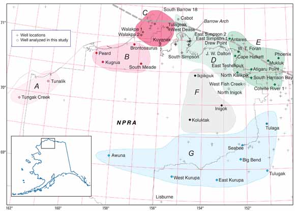
National Petroleum Reserve in Alaska (NPRA), showing locations of wells in areas A through G used in this study (from figure 1). |
|
Porosity decreases with depth in sedimentary basins, owing to the combined effects of compaction and cementation. The porosity profile in any individual well depends on the maximum effective stress, which is generally determined by the maximum burial depth. As a result, present-day porosity profiles can be interpreted in terms of maximum burial depth and subsequent uplift. Using sonic logs and porosity measurements in cored wells, we adapt a method of calculating porosity in siliciclastic rocks from sonic logs and compare it with several other algorithms relating sonic velocity and porosity. We then calculate porosity from sonic logs in wells within and adjacent to the National Petroleum Reserve in Alaska (NPRA). Evaluating the shale-rich Early Cretaceous Torok Formation, we observe that the porosity-depth relation can be represented by one or two straight lines in each well. The porosity-depth lines are offset among wells in different areas within the northern NPRA, reflecting differences in uplift along the Barrow Arch. When the line segments are replotted in terms of porosity against vitrinite reflectance instead of present-day depth, the trends from areas within the coastal plain nearly coalesce, showing that the effect of maximum burial depth explains much, but not all, of the differences in the porosity profiles. Relative to a single offshore well where zero uplift is assumed to have occurred, estimates of uplift along the Barrow Arch range from less than 1,000 ft just east of the NPRA to 4,600 ft at Point Barrow. In the foothills of the southern NPRA, the computational method can provide only minimum estimates of uplift, which are less than, but compatible with, estimates of uplift based on the apatite fission-track method. The porosity gradients in wells in the northern NPRA (coastal plain and near offshore) are similar to those in wells in other areas calculated by other workers: about 3 percent per 1,000 ft. In the southern NPRA (foothills), porosity gradients are lower than in the northern NPRA - that is, porosity decreases less rapidly with depth in the foothills (approximately 1 percent per 1,000 ft) than in the coastal plain (max 12 percent per 1,000 ft). An explanation of the wide variation in porosity gradients in the NPRA awaits a better understanding of the evolution of pore pressure and effective stress within the context of the burial and uplift history of the Colville Basin. |
Download this report as a 28-page PDF file (3.6 MB)
For questions about the content of this report, contact Philip Nelson
|
Help |
PDF help |
Publications main page |
This report is available only on the Web