U.S. Geological Survey Scientific Investigations Report 2005-5065
Back to the Table of Contents
During 2002 – 03, the U.S. Geological Survey (USGS) — in cooperation with State, local, and Federal agencies — conducted various hydrologic studies that provided information to better define and manage the State's water resources. Selected technical highlights from the USGS programs conducted in Georgia include:
The Upper Floridan aquifer is the principal source of water in the coastal area of Georgia. Declining water levels and localized saltwater contamination have resulted in regulators restricting withdrawals from the aquifer in parts of the coastal area, and have prompted interest in developing supplemental sources of ground-water supply. These supplemental sources of water include the surficial aquifer system, Brunswick aquifer system, and Lower Floridan aquifer.
The U.S. Geological Survey (USGS) — in cooperation with the Liberty County Development Authority and the Georgia Department of Natural Resources, Environmental Protection Division (GaEPD) — conducted an evaluation of the potential for alternative sources of ground water at a site located near Old Sunbury Road, in the eastern part of Liberty County. The purpose of this study was to estimate the hydraulic properties and collect water-quality data for the upper confined zone of the surficial aquifer system and the lower Brunswick aquifer of the Brunswick aquifer system. The scope of this study included construction of test wells, collection of lithologic cuttings, borehole geophysical logging, aquifer testing and subsequent analysis, and water-quality sampling and analysis. These data are important for the successful development and management of ground-water resources in the county.
Any use of trade, product, or firm names in this publication is for descriptive purposes only and does not imply endorsement by the U.S. Government.
The test site is located in eastern Liberty County, Georgia, in the Coastal Plain physiographic province. The site is about 23 miles south of the city of Savannah and 16 miles east of the city of Hinesville (maps at right and facing page). Land use in the area primarily is forest. Topographic relief across the area is low, and approximate land-surface altitude is 10 feet (ft) above the North American Vertical Datum of 1988 (NAVD 88). The climate in the area is humid and subtropical with a mean annual temperature of 66.2 degrees Fahrenheit at Savannah Municipal Airport (National Oceanic Atmospheric Administration, 2002). For the 30-year period 1971– 2000, average monthly precipitation ranged from 2.49 inches during November to 7.20 inches during August, and annual precipitation averaged 49.58 inches (National Oceanic Atmospheric Administration, 2002).
![]() Old Sunbury Road test site, eastern Liberty County, Georgia.
Old Sunbury Road test site, eastern Liberty County, Georgia.
To better identify the water-bearing characteristics and lithology of the surficial and Brunswick aquifer systems, six wells were drilled. One well was completed in the upper confined zone of the surficial aquifer system (upper confined zone) (35N072) and in the lower Brunswick aquifer (35N071). An observation well was completed in the water-table zone of the surficial aquifer system (water-table zone) (35N076), upper confining unit overlying the confined zone of the surficial aquifer system (confining unit) (35N075), upper confined zone (35N074), and the lower Brunswick aquifer (35N073).
Wells 35N072 and 35N071 were completed on January 21, 2003, and December 5, 2002, respectively; the four observation wells (35N076, 35N075, 35N074, and 35N073) were completed at approximately the same time using standard mud-rotary techniques, except for well 35N076, which was hand augured (well construction table, below).
Well location and construction for aquifer test at Old Sunbury Road test site, Liberty County, Georgia
[OW, observation well; PW, pumping well; WT, water-table zone; CU, confining unit; UCZ, upper confined zone; —, not applicable; do., ditto]
| Well name | Other identifier | Well depth (feet below land surface) | Casing depth (feet below land surface) | Casing diameter (inches) | Altitude (feet) | Type of opening | Aquifer | Aquifer zone | ||
|---|---|---|---|---|---|---|---|---|---|---|
| Top of screen or open interval | Bottom of screen or open interval | Land surface | ||||||||
| 35N076 | Old Sunbury Road OW-4 | 8 | 8 | 2 | 5 | 2 | 10 | Screened | Surficial | WT |
| 35N075 | Old Sunbury Road OW-3 | 52 | 52 | 4 | – 42 | – 43 | do. | do. | do. | CU |
| 35N072 | Old Sunbury Road PW-2 | 150 | 150 | 6 | – 50 | –140 | do. | do. | do. | UCZ |
| 35N074 | Old Sunbury Road OW-2 | 65 | 65 | 4 | – 50 | – 55 | do. | do. | do. | do. |
| 35N071 | Old Sunbury Road PW-1 | 365 | 365 | 6 | – 305 | – 355 | do. | do. | Lower Brunswick | — |
| 35N073 | Old Sunbury Road OW-1 | 322 | 322 | 4 | – 307 | – 312 | do. | do. | do. | — |
1Negative value denotes below NAVD 88
On completion of the deepest hole (well 35N071), borehole geophysical logs were collected including natural-gamma radiation, spontaneous potential, lateral resistivity, short- and long-normal resistivity, and caliper. Borehole geophysical logs and lithologic cuttings were used to select casing depths and screened intervals for each well. Natural-gamma radiation and electric logs were used to verify the correlation of the stratigraphic units and identify water-bearing zones. Lithologic cuttings were collected during the drilling of well 35N071 and used to determine the location of the A-, B-, and C-marker horizons. These markers are used to identify the tops of the upper Brunswick, lower Brunswick, and Upper Floridan aquifers, respectively, and are characterized by a sharp increase in natural-gamma radiation (Clarke and others, 1990). Lithologic and hydrogeologic descriptions for well 35N071 derived from the lithologic cuttings and borehole geophysical logs were related to stratigraphic description of a well drilled in McIntosh County, Georgia (Weems and Edwards, 2001).
Pretest ground-water levels were monitored prior to the start of each aquifer test using pressure transducers and data loggers. Ground-water levels in wells 35N075, 35N074, and 35N073 were monitored prior to the aquifer test in the upper confined zone (well 35N072). Ground-water levels in wells 35N074, 35N072, 35N073, and 35N071 were monitored prior to the lower Brunswick aquifer test (well 35N071).
Pretest pumping was conducted to verify that the pumped wells were fully developed and to determine the optimum pumping rate prior to the pumping phase of the aquifer tests. This pumping also ensured that the drawdown in the pumped wells would not exceed the depth of the pressure transducer or induce cavitation (bubbling) in the wells. During the pretest pumping and subsequent aquifer test, ground-water levels were measured using an In-Situ, Inc. Hermit 3000© data logger with a 100-pound-per-square-inch (psi) pressure transducer in the pumping well and an In-Situ, Inc. Hermit 2000© data logger with either a 20- or 30-psi transducer in the observation wells. Verification measurements were made using dedicated electric tapes to confirm proper operation of the pressure transducers and data loggers. Atmospheric pressure was measured with an internal pressure sensor in the data loggers. Starting at time equals 0, a sampling interval was programmed into the data logger to facilitate the rapid collection of early time data, using a logarithmic scale that was decreased to a 1-minute interval.
A 5-horsepower submersible pump was used for constant ground-water withdrawals from wells 35N072 and 35N071. A trailer-mounted diesel-powered electric generator provided power to the submersible pump. About 80 ft of 6-inch- diameter polyvinyl chloride pipe was used to transport water away from the wells. Ground-water discharge was measured using a totalizing flowmeter. An appropriate discharge was determined during pretest pumping and was held constant throughout the duration of the aquifer tests.
An aquifer test was performed in the upper confined zone using pumping well 35N072 and observation wells 35N076, 35N075, 35N074, 35N073, and 35N071. An aquifer test was performed in the lower Brunswick aquifer using pumping well 35N071 and observation wells 35N072, 35N074, and 35N073. Data from these aquifer tests were analyzed to estimate trans-missivity, storage coefficient, and hydraulic conductivity for the aforementioned water-bearing units.
During the aquifer test, the magnitude of water-level fluctuation produced by changes in atmospheric pressure, local pumping, or tidal oscillations was minor in comparison to the amount of drawdown induced by the pump. Therefore, data used in the aquifer-test analysis were not corrected for atmospheric pressure, local pumping, or tidal effects.
Drawdown and recovery data were analyzed using the nonequilibrium method of Theis (1935), the modified nonequilibrium analytical model of Cooper and Jacob (1946), and the Hantush and Jacob (1955) analytical model for nonsteady radial flow in an infinite leaky aquifer. The Hantush and Jacob (1955) method accounts for leakage, but does not differentiate between leakage above or below the aquifer.
Water samples were collected from wells 35N072 and 35N071 and analyzed for major ions, nutrients, metals, and radionuclides. Based on major ionic composition, results from the chemical analyses were used to describe the ground-water quality and to differentiate the chemical quality between the water-bearing units. Water samples were collected after several hours of pumping when field properties had stabilized. Field properties were measured in a flow-through chamber using a DataSonde® Hydrolab® 4 Water Quality multiprobe following USGS protocols (Wilde and Radtke, 1999). Whole-water samples were preserved and stored in polyethylene or acid-rinsed bottles and sent by overnight carrier to the USGS National Water Quality Laboratory, Denver, Colorado.
Previous Investigations
Clarke and others (1990) defined the surficial and upper and lower Brunswick aquifers and described their water-bearing characteristics. Steele and McDowell (1998) mapped the permeable thickness and areal distribution of the upper and lower Brunswick aquifers. Sharpe and others (1998) described results of a lower Brunswick aquifer test in Chatham County, Georgia. Leeth (1999) described the hydrogeology of the surficial aquifer at Naval Submarine Base Kings Bay in Camden County, Georgia. More recent investigations include Gill (2001), who described the development potential of the upper and lower Brunswick aquifers in Glynn and Bryan Counties, Georgia; Radtke and others (2001), who described the results of an engineering assessment of the "Miocene" aquifer system in coastal Georgia; Weems and Edwards (2001) who described the geology of Oligocene and younger deposits in coastal Georgia; and Clarke (2003), who described the surficial and Brunswick aquifer systems as alternative sources of ground water.
Hydrologic units in Liberty County, Georgia, include in descending order, the surficial aquifer system, consisting of the water-table zone, upper confined zone, and lower confined zone (Clarke, 2003); the Brunswick aquifer system, consisting of the upper Brunswick and lower Brunswick aquifers (Clarke and others, 1990); and the Upper Floridan aquifer (Miller, 1986) (hydrogeologic chart, facing page). The upper confined zone of the surficial aquifer system and lower Brunswick aquifer are the focus of this study. The lithology of the upper confined zone consists of sand interbedded with clay and silt with shell fragments; these sediments overlay the micritic limestone and sandy limestone of the lower Brunswick aquifer.
At the Old Sunbury Road test site, the surficial aquifer system is present from land surface to 210 ft below land surface (bls). For this study, it is informally divided into a water-table zone, an upper confined zone, and a lower confined zone. These water-bearing zones are separated by clay confining units. The upper confined zone is the zone that is being investigated. The upper confined zone is present from 70 to 150 ft bls and consists mostly of fine to coarse sand interbedded with clay and silt. The thickness of the upper confined zone is approx-imately 80 ft. The confining unit underlying the surficial aquifer system is identified on natural-gamma radiation logs by the A-marker horizon, which is present just above the upper Brunswick aquifer (Clarke and others, 1990). Well 35N072 is screened through the upper confined zone.
At the Old Sunbury Road test site, the lower Brunswick aquifer extends from 315 to 365 ft bls and consists of micritic limestone with partially cemented, mostly fine to medium grained, sandy limestone. The thickness of the lower Brunswick aquifer is 50 ft. The top of the aquifer was determined by locating the B-marker horizon identified by a sharp increase in natural gamma radiation on the natural-gamma log (Clarke and others, 1990). The bottom of the aquifer was determined by the location of the C-marker horizon, which coincides with the top of the Upper Floridan aquifer (Clarke and others, 1990). The C-marker horizon is present near the top of the Suwannee Limestone in the study area. Well 35N071 is screened in the lower Brunswick aquifer.
Each multiwell aquifer test was designed to provide hydraulic data to calculate the hydraulic properties for the upper confined zone and the lower Brunswick aquifer. Aquifer tests consisted of background water-level monitoring prior to the test, pretest pumping, constant discharge pumping test, and post-test water-level monitoring.
Analysis of drawdown data using graphs aid in the determination of the accuracy of estimated hydraulic properties. Typically, the early part of a drawdown curve is steep showing well-storage effects, the middle part follows a straight line as water enters the well from the aquifer, the latter part continues along a straight line until the aquifer reaches steady-state conditions. A change in the slope in the latter part of the curve represents either recharge (leakage) to the aquifer or contact with an impermeable boundary. Leakage or recharge would cause drawdown to decrease, whereas contact with an impermeable boundary would cause drawdown to increase. Early termination of a test would result in an underestimation of hydraulic properties.
Hydraulic properties determined from the upper confined zone of the surficial aquifer system (35N072) and lower Brunswick aquifer (well 35N071) tests, January –February 2003. [ft2/d, feet squared per day; ft/d, feet per day; storage coefficient is dimensionless; —, no data]
| Well name | Transmissivity (ft2/d) | Hydraulic conductivity (ft/d) | Storage coefficient | Condition | Method used | Date of aquifer test |
|---|---|---|---|---|---|---|
| Upper confined zone of the surficial aquifer system test | ||||||
| 35N072 | 400 | 4 | — | Drawdown | Cooper and Jacob (1946) | Feb 5 –7, 2003 |
| 35N072 | 400 | 4 | — | Recovery | Cooper and Jacob (1946) | — |
| 35N074 | 600 | 7 | — | Drawdown | Hantush and Jacob (1955) | — |
| Lower Brunwick aquifer test | ||||||
| 35N071 | 600 | 10 | — | Drawdown | Cooper and Jacob (1946) | Jan 14 –17, 2003 |
| 35N073 | 400 | 9 | 0.00004 | Drawdown | Hantush and Jacob (1955) | — |
The upper confined zone multiwell aquifer test consisted of pumping the upper confined zone well 35N072 while monitoring water levels in observation well 35N074 open to the upper confined zone. Additionally, the water-table zone well 35N076, confining-unit well 35N075, and lower Brunswick aquifer wells 35N071 and 35N073 were monitored. Prior to the upper confined zone aquifer test, water levels were monitored for 6 days. The test was conducted February 6 –7, 2003, and consisted of 24 hours of constant pumping and 24 hours of water-level recovery. During the pretest period (January 29 – February 3, 2003), water levels ranged from 3.43 to 3.49 ft bls in well 35N076 open to the water-table zone; from 8.54 to 8.87 ft bls in well 35N075 open to the confining unit; from 12.52 to 12.76 ft bls in well 34N074, open to the upper confined zone; and from 46.97 to 47.22 bls in well 35N073, open to the lower Brunswick aquifer. Average discharge during the test was 39.8 gallons per minute (gal/min), with a total drawdown of 28.7 ft after 24 hours of pumping (graphs, facing page).
Results from the drawdown and recovery data analysis using the Cooper and Jacob (1946) and Hantush and Jacob (1955) analytical methods provided a reasonable estimation of the hydraulic properties for the upper confined zone. Using both drawdown and recovery data, results from the two solutions indicate the transmissivity of the upper confined zone ranges from 400 to 600 feet squared per day (ft2/d) with a hydraulic conductivity ranging from 4 to 7 feet per day (ft/d) (hydraulic properties table, below).
The lower Brunswick aquifer test consisted of pumping and monitoring well 35N071, while monitoring the ground-water levels in the observation well 35N073 open to the lower Brunswick aquifer. Additionally, upper confined zone wells 35N072 and 35N074 were monitored. Prior to the lower Brunswick aquifer test, water levels were monitored for 11 days. The test was conducted January 14 –16, 2003, and consisted of 48 hours of constant pumping and 20 hours of water-level recovery. During the pretest period (January 2–13, 2003), the water levels ranged from 8.15 to 8.48 ft bls in wells 35N072 and 35N074 open to the upper confined zone, respectively; and from 47.24 to 47.60 ft bls in wells 35N071 and 35N073, open to the lower Brunswick aquifer, respectively. Average discharge during the test was 78.5 gal/min with a total drawdown of 50.2 ft bls after 48 hours of pumping (graphs, page 90).
Results from the analyses of the drawdown data from well 35N071 using the Cooper and Jacob (1946) and Hantush and Jacob (1955) analytical methods provided a reasonable estimation of the hydraulic properties for the lower Brunswick aquifer. Results from the two solutions indicate the transmissivity for the lower Brunswick aquifer ranges from 400 to 600 ft2/d with a hydraulic conductivity ranging from 9 to 10 ft/d (hydraulic properties table, facing page).
Results of the chemical analyses for the ground-water samples obtained from wells completed in the upper confined zone and the lower Brunswick aquifer were used to compare the geochemical variability of ground water in the two aquifers. Water samples from wells 35N072 and 35N071 were analyzed for major ions, metals, total organic carbon, nutrients, and radionuclides (water-quality table, page 92). Field properties including pH, specific conductance, and water temperature were measured prior to sample collection. Concentrations of constituents were compared to the U.S. Environmental Protection Agency (USEPA) (2000a, 2000b) maximum contaminant levels (formerly known as primary maximum contaminant level) and secondary standards (formerly known as secondary maximum contaminant level) for drinking water. These data were compared to the Georgia Environmental Protection Division (GaEPD) (1997a, 1997b) regulations for drinking water.
Graphical methods for the presentation of water-quality data provide a means to distinguish the chemical properties of ground water from various water-bearing zones. A trilinear diagram illustrating the percent composition of selected major cations and anions, as well as dissolved-solid concentrations for these constituents for the upper confined zone and lower Brunswick aquifer is shown at right. As the diagram shows, water from the upper confined zone is a calcium-chloride type and water from the lower Brunswick aquifer is a carbonate type, with the upper confined zone having a lower concentration of dissolved solids than the lower Brunswick aquifer. Hardness of water in the upper confined zone is 30 milligrams per liter (mg/L) as calcium carbonate (CaCO3) and hardness of water in the lower Brunswick aquifer is 100 mg/L as CaCO3 (based on the sum of milliequivalents of calcium, magnesium, barium, and strontium). According to the classification of Durfor and Becker (1964), the ground water in the upper confined zone is categorized as soft and the ground water in the lower Brunswick aquifer is categorized as moderately hard.
Water from the upper confined zone of the surficial aquifer system has an iron concentration of 1,263 micrograms per liter, which exceeds the drinking-water standard of 300 mg/L, and the pH value of 5.6 falls below the USEPA and GaEPD secondary drinking-water standard of 6.5. Tritium was analyzed in samples from the upper confined zone of the surficial aquifer system to determine if water was entering the aquifer from surface recharge. Tritium in the water is less than the reporting limit of 5.7 picoCuries per liter, which is not indicative of leakage or recharge. Water from the upper confined zone has a chloride concentration of 8.59 mg/L, specific conductance of 104 microsiemens per centimeter (µS/cm), and total organic carbon concentration of 1.74 mg/L.
Water from the lower Brunswick aquifer has no major ionic concentrations that exceed drinking-water standards and the pH value of 8.08 is within the range of 6.5 – 8.5 for secondary drinking-water standards. Water from the lower Brunswick aquifer has a dissolved chloride concentration of 4.58 mg/L and specific conductance of 285 µS/cm.
![]() Percent composition of major ionic constituents and dissolved solids in water from upper confined zone of the surficial aquifer and lower Brunswick aquifer, Old Sunbury Road test site, Liberty County, Georgia, January 15 and February 5, 2003.
Percent composition of major ionic constituents and dissolved solids in water from upper confined zone of the surficial aquifer and lower Brunswick aquifer, Old Sunbury Road test site, Liberty County, Georgia, January 15 and February 5, 2003.
Field properties, major ions, and selected trace elements in water samples collected from the upper confined zone of the surficial aquifer system (well 35N072) and lower Brunswick aquifer (well 35N071), Old Sunbury Road test site, Liberty County, Georgia, January – February, 2003, and drinking-water standards for selected constituents.
[MCL, primary maximum contaminant level; SMCL, secondary maximum contaminant level; TT, treatment technique; mg/L, milligram per liter; —, no data available; bold where sample exceeded standard; µS/cm, microsiemens per centimeter; CaCO3, calcium carbonate; <, less than; E, estimated value; µg/L, microgram per liter; pCi/L, picoCurie per liter]
| Constituents | Test well number and water-bearing zone | Drinking-water standards1 | |||
|---|---|---|---|---|---|
| 35N072, upper confined zone | 35N071, lower Brunswick aquifer | MCL | SMCL | TT | |
| Dissolved oxygen, mg/L | 0.9 | 0.1 | — | — | — |
| Field pH, standard units | 5.6 | 8 | — | 6.5 – 8.5 | — |
| Lab pH, standard units | 6.5 | 8.1 | — | 6.5 – 8.5 | — |
| Field specific conductance, in µS/cm | 104 | 276 | — | — | — |
| Lab specific conductance, in µS/cm | 106 | 285 | — | — | — |
| Water temperature, in degrees Celsius | 20.6 | 22.8 | — | — | — |
| Hardness as mg/L CaCO3 | 30 | 100 | — | — | — |
| Calcium, dissolved, mg/L | 9.48 | 20.8 | — | — | — |
| Magnesium, dissolved, mg/L | 1.41 | 11.6 | — | — | — |
| Potassium, dissolved, mg/L | 1.18 | 3.81 | — | — | — |
| Sodium, dissolved, mg/L | 7.19 | 19.7 | — | — | — |
| Alkalinity as CaCO3, mg/L | 35 | 106 | — | — | — |
| Chloride, filtered, mg/L | 8.59 | 4.58 | — | 250 | — |
| Silica, dissolved, mg/L | 29.2 | 35.9 | — | — | — |
| Sulfate, dissolved, mg/L | 0.2 | 20.8 | — | 250 | — |
| Dissolved solids (sum of constituents), mg/L | 57 | 117 | — | 500 | — |
| Ammonia, dissolved, mg/L | 0.17 | 0.08 | — | — | — |
| Nitrite, nitrate, as N, dissolved, mg/L | <.022 | <0.022 | 10 | — | — |
| Phosphorus, filtered, dissolved, mg/L | 1.35 | E0.003 | — | — | — |
| Phosphorus, unfiltered, dissolved, mg/L | 1.33 | 0.005 | — | — | — |
| Organic carbon, total, in mg/L | 1.74 | — | — | — | — |
| Aluminum, dissolved, in µg/L | <20 | E8.6 | — | 50 – 200 | — |
| Antimony, dissolved, in µg/L | <.30 | <.30 | 6 | — | — |
| Barium, dissolved, in µg/L | 13 | 2 | 2,000 | — | — |
| Beryllium, filtered, in µg/L | E.03 | <.06 | 4 | — | — |
| Cadmium, filtered, in µg/L | <.04 | <.04 | 5 | — | — |
| Chromium, dissolved, in µg/L | <.8 | <.8 | 100 | — | — |
| Cobalt, filtered, in µg/L | 0.02 | 0.04 | — | — | — |
| Copper, filtered, in µg/L | <.2 | E.2 | — | 1,000 | 1,300 |
| Iron, dissolved, in µg/L | 1,263 | <10 | — | 300 | — |
| Lead, filtered, in µg/L | 0.12 | <.08 | — | — | 15 |
| Manganese, dissolved, in µg/L | 37.2 | <2.0 | — | 50 | — |
| Molybdenum, dissolved, in µg/L | <.3 | 0.5 | — | — | — |
| Nickel, filtered, in µg/L | 0.4 | 0.7 | 100 | — | — |
| Siver, dissolved, in µg/L | <.20 | <.20 | — | 100 | — |
| Strontium, dissolved, in µg/L | 66.8 | 390 | — | — | — |
| Zinc, dissolved, in µg/L | E19 | <24 | — | 5,000 | — |
| Alpha radioactivity, 2-sigma, Th-230, in pCi/L | — | 2 | 15 | — | — |
| Alpha radioactivity,Th-230, in pCi/L | — | 1.8 | — | — | — |
| Beta radioactivity, 2-sigma, CS-137, in pCi/L | — | 1.3 | — | — | — |
| Gross beta radioactivity, CS-137, in pCi/L | — | 5.4 | — | — | — |
| Tritium 2-sigma, in pCi/L | 3.2 | — | — | — | — |
| Tritium, total, in pCi/L | <5.7 | — | — | — | — |
| Uranium, filtered, in µg/L | E.01 | E.01 | 30 | — | — |
1U.S. Environmental Protection Agency, 2000a, 2000b
Clarke, J.S., 2003, The surficial and Brunswick aquifer systems—Alternative ground-water resources for coastal Georgia in Proceedings of the 2003 Georgia Water Re-sources Conference held April 23 –23, 2003, at The Uni-versity of Georgia, K.J. Hatcher (ed), Institute of Ecology, The University of Georgia, Athens, Ga., CD – ROM.
Clarke, J.S., Hacke, C.M., and Peck, M.F., 1990, Geology and ground-water resources of the coastal area of Georgia: Georgia Geologic Survey Bulletin 113, 106 p.
Cooper, H.H., Jr., and Jacob, C.E., 1946, A generalized graphical method for evaluating formation constants and summarizing well-field history: Transactions, American Geophysical Union, v. 27, p. 526 – 534.
Durfor, C.N., and Becker, Edith, 1964, Public water supplies of the 100 largest cities in the United States, 1962: U.S. Geological Survey Water-Supply Paper 1812, 364 p.
Georgia Environmental Protection Division, 1997a, Primary maximum contaminant levels for drinking water: Environmental Rule 391-3-5-18, revised October 1997: Official Code of Georgia Annotated Statutes, Statue 12-5-170 (Georgia Safe Drinking Water Act), variously paginated.
Georgia Environmental Protection Division, 1997b, Secondary maximum contaminant levels for drinking water: Environmental Rule 391-3-5-19, revised October 1997: Official Code of Georgia Annotated Statutes, Statue 12-5-170 (Georgia Safe Drinking Water Act), variously paginated.
Gill, H.E., 2001, Development of long-term sustainable water supplies from the Miocene upper and lower Brunswick aquifers, Glynn and Bryan Counties, Georgia, in Proceedings of the 2001 Georgia Water Resources Conference, March 26 –27, 2001, K.J. Hatcher (ed.), Institute of Ecology, The University of Georgia, Athens, Ga., p. 660 – 664.
Hantush, M.S., and Jacob, C.E, 1955, Non-steady radial flow in an infinite leaky aquifer: Transactions of the American Geophysical Union, v. 36, no. 1, p. 95 –100.
Leeth, D.C., 1999, Hydrogeology of the surficial aquifer in the vicinity of a former landfill, Naval Submarine Base Kings Bay, Camden County, Georgia: U.S. Geological Survey Water-Resources Investigations Report 98-4246, 28 p.
Miller, J.A., 1986, Hydrogeologic framework of the Floridan aquifer system in Florida and in parts of Georgia, Alabama, and South Carolina: U.S. Geological Survey Professional Paper 1403-B, 91 p.
National Oceanic and Atmospheric Administration, 2002, National Environmental Satellite, Data and Information Service, National Climatic Data Center, Monthly station normals of temperature, precipitation, and heating and cooling degree days 1971– 2000: Asheville, N.C., no. 81, 28 p.
Radtke, J.S., Hemingway, C.D., and Humphries, Robert, 2001, Engineering assessment of the Miocene aquifer system in coastal Georgia in Proceedings of the 2001 Georgia Water Resources Conference, March 26 –27, 2001, K.J. Hatcher (ed.), Institute of Ecology, The University of Georgia, Athens, Ga., p. 665 – 668.
Sharpe, Bill, Watson, Sam, and Hodges, R.A., 1998, Aquifer performance test report: Tybee Island Miocene (upper Brunswick) aquifer, Chatham County, Georgia, March 19 –23, 1997: Georgia Geologic Survey Project Report 33, 33 p.
Steele, W.M., and McDowell, R.J., 1998. Permeable thickness of the upper and lower Brunswick aquifers, coastal area, Georgia. Georgia Geologic Survey Information Circular 103, 34 p.
Theis, C.V., 1935, The relation between the lowering of the piezometric surface and the rate and duration of discharge of a well using ground-water storage: Transactions of the American Geophysical Union, v. 16, p. 519 – 524.
U.S. Environmental Protection Agency, 2000a, Maximum contaminant levels (Subpart B of part 141, National Primary Drinking-Water Regulations): U.S. Code of Federal Regulations, Title 40, parts 100 –149, revised as of July 1, 2000, p. 334 – 560.
U.S. Environmental Protection Agency, 2000b, Maximum contaminant levels (Subpart B of part 143, National Secondary Drinking-Water Regulations): U.S. Code of Federal Regulations, Title 40, parts 100 –149, revised as of July 1, 2000, p. 612 – 614.
Weems, R.E., and Edwards, L.E., 2001, Geology of Oligocene, Miocene, and younger deposits in the coastal area of Georgia: Georgia Geologic Survey Bulletin 131, 124 p.
Wilde, F.D., and Radtke, D.B., 1999, Field measurements, in Wilde, F.D., Radtke, D.B., Gibs, Jacob, and Iwatsubo, R.T., eds., National field manual for the collection of water- quality data: Handbook for water-resources investigations, U.S. Geological Survey, p. 31.
The Upper Floridan aquifer is the principal source of water in the coastal area of Georgia. Declining water levels and localized occurrences of saltwater contamination have resulted in regulators restricting withdrawals from the aquifer in portions of the coastal area, and have prompted interest in developing supplemental sources of ground-water supply. These supplemental sources of water include the surficial aquifer system, the Brunswick aquifer system, and the Lower Floridan aquifer.
The U.S. Geological Survey (USGS) — in cooperation with Camden County and the Georgia Department of Natural Resources, Environmental Protection Division (GaEPD) — conducted an evaluation of the potential for alternative sources of ground water at a site located near Waverly in the northern part of Camden County. The purpose of this study was to calculate the hydraulic properties and collect water-quality data for the confined zone of the surficial aquifer system (confined surficial aquifer) and for the upper Brunswick aquifer of the Brunswick aquifer system. The scope of this study included construction of test wells, collection of lithologic cuttings, borehole geophysical logging, aquifer testing and subsequent analyses, and water-quality sampling and analysis. These data are important for the successful development and management of ground-water resources in the county.
Any use of trade, product, or firm names in this publication is for descriptive purposes only and does not imply endorsement by the U.S. Government.
The site is located in northern Camden County, Georgia, in the Coastal Plain physiographic province, and is about 13 miles southwest of the city of Brunswick and 1 mile east of the city of Waverly (maps at right and facing page). Land use in the area primarily is forest. Topographic relief across the area is low, with approximate land-surface altitude of 20 feet (ft) above North American Vertical Datum of 1988 (NAVD 88). The climate in the area is mild with a mean annual temper- ature of 69.5 degrees Fahrenheit at Brunswick National Weather Station (National Oceanic Atmospheric Administration, 2002). For the 30-year period 1971– 2000, average monthly precipitation ranged from 2.49 inches per month during November to 6.50 inches per month during August, and annual precipitation averaged 49.42 inches (National Oceanic Atmospheric Administration, 2002).
![]() Waverly test site, northern Camden County, Georgia.
Waverly test site, northern Camden County, Georgia.
To better identify the water-bearing capability and lithology of the surficial and Brunswick aquifer systems, three wells were drilled. One well was completed in the confined surficial aquifer (32G048), and a second well was completed in the upper Brunswick aquifer (32G047). A third well (32G046) was drilled in the lower Brunswick aquifer; however, this well was not completed nor tested because of an obstruction in the well. Lithologic cuttings and borehole geophysical logs were collected from well 32G046. In the other two wells, background water-level monitoring and aquifer testing were performed and water-quality samples were collected and analyzed. The wells completed in the confined surficial and upper Brunswick aquifers partially penetrate the aquifer. Wells 32G048, 32G047, and 32G046 were drilled during November 2002 – February 2003 using standard mud-rotary techniques. The table below presents the well construction information.
Well location and construction for aquifer test at Waverly test site, Camden County, Georgia
[bls, below land surface; PW, pumping well; —, not applicable]
| Well name | Other identifier | Land surface elevation (feet) | Well depth (feet bls) | Casing depth (feet bls) | Casing diameter (inches) | Top of screen or open interval (feet bls) | Bottom of screen or open interval (feet bls) | Type of opening | Screendiameter | Aquifer |
|---|---|---|---|---|---|---|---|---|---|---|
| 32G048 | Waverly Fire Station PW-2 | 20 | 195 | 110 | 6 | 110 | 190 | Screened | 4 | Confined surficial |
| 32G047 | Waverly Fire Station PW-1 | 20 | 295 | 240 | 6 | 250 | 290 | Screened | 4 | Upper Brunswick |
| 32G046 | Waverly Fire Station | 20 | 455* | 370 | 6 | — | — | Open | 6 | Lower Brunswick |
* Well collapsed at 430 feet
On completion of the deepest hole (well 32G046), borehole geophysical logs were collected that included natural-gamma radiation, spontaneous potential, lateral resistivity, short- and long-normal resistivity, and caliper. The borehole geophysical logs and lithologic cuttings were used to select casing depth and screened intervals for each well. Natural-gamma radiation and electric logs were used to support correlation of stratigraphic units and identify water-bearing zones. Lithologic cuttings were collected throughout the drilling of well 32G046 and used to help determine the location of the A-, B-, and C-marker horizons. These markers are distinct stratigraphic horizons that are used to identify the tops of the upper Brunswick, lower Brunswick, and Upper Floridan aquifers, respectively, and are identified by a sharp change in radiation in the natural-gamma logs (Clarke and others, 1990). Lithologic and hydrogeologic descriptions for well 32G046 derived from lithologic cuttings and borehole geophysical logs were related to the stratigraphic descripton of a well drilled at St. Marys, Camden County, Georgia (Weems and Edwards, 2001).
Pretest ground-water levels were monitored before the start of each aquifer test using pressure transducers and data loggers. Ground-water levels in well 32G048 were monitored prior to the aquifer test in the confined surficial aquifer. Additionally, ground-water levels in wells 32G048 and 32G047 were monitored prior to the upper Brunswick aquifer test.
Pretest pumping was performed to verify that wells 32G048 and 32G047 were fully developed and to determine the optimum pumping rate for the 24-hour pumping phase of the aquifer tests. This pumping also ensured that the drawdown in the wells would not exceed the depth of the pressure transducer or induce cavitation (bubbling). During the pretest pumping and subsequent aquifer test, ground-water levels were measured and recorded using an In-Situ, Inc. Hermit 3000© data logger with 100-pound-per-square-inch (psi) pressure transducers in wells 32G047 and 32G048 and with a 20-psi pressure transducer confined surficial aquifer well 32G048 during the upper Brunswick aquifer test. Verification measurements were made using dedicated electric tapes to confirm proper operation of the pressure transducers and data logger. Atmospheric pressure was measured with an internal pressure sensor in the data logger. Starting at time equals 0, a sampling interval was programmed into the data logger to facilitate the rapid collection of early time data, using a logarithmic scale that was decreased to a 1-minute interval.
A 2½-horsepower submersible pump was used for constant ground-water withdrawals for wells 32G048 and 32G047. Approximately 60 ft of 4-inch-diameter hose was used to transport water away from the wells. Ground-water discharge was measured using a Model FL-30005 Closed Pipe System Water Measurement Flowmeter. An appropriate discharge was determined during pretest pumping and was constantly maintained throughout the duration of the aquifer tests.
An aquifer test was performed in the confined surficial aquifer using well 32G048 and in the upper Brunswick aquifer using well 32G047. Data from aquifer tests were analyzed to calculate transmissivity and hydraulic conductivity for the aforementioned water-bearing units.
During the aquifer tests, the magnitude of water-level fluctuation produced by changes in atmospheric pressure, local pumping, or tidal oscillations was minor in comparison to the amount of drawdown induced by the pump. Therefore, the data used in the analysis of the aquifer tests were not corrected for atmospheric pressure, local pumping, or tidal effects.
Drawdown and recovery data were analyzed using the nonequilibrium method of Theis (1935), the modified nonequilibrium analytical model of Cooper and Jacob (1946), and the Hantush and Jacob (1955) analytical model for nonsteady radial flow in an infinite leaky aquifer. The Hantush and Jacob (1955) method accounts for leakage, but does not differentiate between leakage from above or below the aquifer.
Water samples were collected after several hours of pumping when field properties were stable. Field properties were measured in a flow-through chamber using DataSonde® Hydrolab® 4 Water Quality multiprobe following USGS protocols (Wilde and Radtke, 1999). Whole-water samples were preserved and stored in polyethylene or acid-rinsed bottles and sent by overnight carrier to the USGS National Water Quality Laboratory, Denver, Colorado (NWQL). Water samples were collected from wells 32G048 and 32G047 and analyzed for major ions, nutrients, metals, and radionuclides. Based on major ionic composition, results from the chemical analyses were used to describe the ground-water quality and to differentiate the chemical quality between the water-bearing units.
Clarke and others (1990) defined the surficial and upper and lower Brunswick aquifers and described their water-bearing characteristics. Sharpe and others (1998) described the results of an aquifer test in the Miocene-aged sediments in Camden County, Georgia. Steele and McDowell (1998) mapped the permeable thickness and areal distribution of the upper and lower Brunswick aquifers. Leeth (1999) described the hydrogeology of the surficial aquifer at Naval Submarine Base Kings Bay in Camden County, Georgia. More recent investigations include Gill (2001), who described the development potential of the upper and lower Brunswick aquifers in Glynn and Bryan Counties, Georgia; Radtke and others (2001), who described the results of an engineering assessment of the "Miocene" aquifer system in coastal Georgia; Weems and Edwards (2001), who described the geology of Oligocene and younger deposits in coastal Georgia; and Clarke (2003), who described the surficial and Brunswick aquifer systems as alternative sources of ground water.
Hydrologic units in Camden County, Georgia, include, but are not limited to, in descending order, the surficial aquifer system, consisting of water-table zone and confined surficial aquifer (Clarke, 2003); the Brunswick aquifer system, consisting of upper and lower Brunswick aquifers (Clarke and others, 1990); and the Upper Floridan aquifer (Miller, 1986) (hydrogeologic chart, facing page). The confined surficial aquifer and upper Brunswick aquifer are the focus of this study. The lithology of the confined surficial aquifer typically consists of sand and clay; these sediments overlay sandy limestone of the Brunswick aquifer system.
At the Waverly test site, the surficial aquifer system is present from land surface to about 195 ft below land surface (bls). For this study, it is informally divided into a water-table zone and the confined surficial aquifer. These water-bearing zones are separated by sandy clay confining units. The confined surficial aquifer is the zone under investigation. The confined surficial aquifer is present from 110 to 195 ft bls and consists of fine to medium sand interbedded with clay. The total thickness of the confined surficial aquifer is about 85 ft. The confining unit underlying the surficial aquifer system is identified on natural-gamma radiation logs by the A-marker horizon, a zone of high natural-gamma radiation, which is present just above the upper Brunswick aquifer (Clarke and others, 1990). Well 32G048 partially penetrates the confined surficial aquifer.
At the Waverly test site, the upper Brunswick aquifer extends from 240 to 300 ft bls and consists of limestone with partially cemented fine to medium sand. The total thickness of the upper Brunswick aquifer is about 60 ft.
Each single-well aquifer test was designed to provide data to calculate the hydraulic properties of the confined surficial and upper Brunswick aquifers. The aquifer tests consisted of a pretest step-drawdown test, background ground-water level monitoring prior to the test, constant discharge pumping test, and post-test water-level monitoring.
Analysis of drawdown data using graphs aid in the determination of the accuracy of estimated hydraulic properties. Typically, the early part of a drawdown curve is steep showing well-storage effects, the middle part follows a straight line as water enters the well from the aquifer, the latter part continues along a straight line until the aquifer reaches steady-state conditions. A change in the slope in the latter part of the curve represents either recharge (leakage) to the aquifer or contact with an impermeable boundary. Leakage or recharge would cause drawdown to decrease, while contact with an impermeable boundary would cause drawdown to increase. Early termination of a test would result in an underestimation of hydraulic properties.
The confined surficial aquifer single-well aquifer test consisted of pumping and monitoring well 32G048. Prior to the confined surficial aquifer test, ground-water levels were monitored for 62 days. The test was conducted December 9 –11, 2003, and consisted of 24 hours of constant pumping and about 26 hours of ground-water-level recovery. During the pretest period (October 7– December 7, 2003), the water-level ranged from 9.48 to 10.5 ft bls. Average discharge during the test was 47.5 gallons per minute (gal/min), with a total drawdown of 30.8 ft bls after 24 hours of pumping (confined surficial aquifer graphs, facing page).
Results from the drawdown and recovery data analysis using Cooper and Jacob (1946) and Hantush and Jacob (1955) methods provided a reasonable estimation of the hydraulic properties for the confined surficial aquifer. Using both drawdown and recovery data, results from the two solutions indicate the average transmissivity for the confined surficial aquifer was 500 feet squared per day (ft2/d) with a hydraulic conductivity of about 6 feet per day (ft/d) (hydraulic properties table, below).
The upper Brunswick aquifer test consisted of pumping and monitoring well 32G047, open to the upper Brunswick aquifer, and monitoring well 32G048, open to the confined surficial aquifer. There was no change in the water level in the confined surficial aquifer, thus no data to analyze. Prior to the upper Brunswick aquifer test, water levels were monitored for 40 days. The test was conducted October 9 –10, 2003, and consisted of 21 hours of constant pumping and 6 days of water level recovery. During the pretest period (August 27– October 5, 2003), the water-level ranged from 5.50 to 6.94 ft above land surface (als). Average discharge during the test was 12 gal/min with a total drawdown of 98.4 ft after 21 hours of pumping (upper Brunswick aquifer graphs, facing page).
Results from recovery data analyses from well 32G047, using the Cooper and Jacob (1946) and Hantush and Jacob (1955) methods, provided a reasonable estimation of the hydraulic properties for the upper Brunswick aquifer. Using the recovery data, results from the two solutions indicate the average trans-missivity of the upper Brunswick aquifer was 70 ft2/day with a hydraulic conductivity of about 2 ft/d (hydraulic properties table, below). Because of the low hydraulic conductivity, the aquifer in this area would not provide enough water to meet most industrial needs, but may meet small domestic needs.
Hydraulic properties determined from the confined surficial aquifer (well 32G048) and upper Brunswick aquifer (well 32G047) tests, Waverly test site, Camden County, Georgia, October 9 –10 and December 9 – 10, 2003.
[ft2/day, feet squared per day; ft/day, feet per day]
| Well name | Transmissivity (ft2/day) | Hydraulic conductivity (ft/day) | Condition | Method used | Date of aquifer test |
|---|---|---|---|---|---|
| Confined surficial aquifer test | |||||
| 32G048 | 500 | 6 | Drawdown | Hantush and Jacob (1955) | Dec 9 –10, 2003 |
| 32G048 | 500 | 6 | Recovery | Cooper and Jacob (1946) | |
| Upper Brunswick aquifer test | |||||
| 32G047 | 70 | 2 | Recovery | Average of Cooper and Jacob (1946) and Hantush and Jacob (1955) | Oct 9 –10, 2003 |
![]() Drawdown and recovery of well 32G047 and 32G048
Drawdown and recovery of well 32G047 and 32G048
Results of the chemical analysis of ground-water samples obtained from wells completed in the confined surficial and upper Brunswick aquifers were used to compare the geo-chemical variability of ground water in the two aquifers. Water samples from wells 32G048 (confined surficial aquifer) and 32G047 (upper Brunswick aquifer) were analyzed for major ions, metals, total organic carbon, nutrients, and radionuclide material (water-quality table, facing page). Field properties including pH, specific conductance, and water temperature were measured onsite prior to sample collection. Concentrations of constituents were compared to the U.S. Environmental Protection Agency (USEPA) (2000a, 2000b) maximum contaminant levels (formerly known as primary maximum contaminant level) and secondary standards (formerly known as secondary maximum contaminant level) for drinking water. Additionally, these data were compared to the GaEPD (1997a, 1997b) regulations for drinking water.
Graphical methods for the presentation of water-quality data provide a means of distinguishing the chemical properties of ground water from different water-bearing zones. A trilinear diagram showing the percent composition of selected major cations and anions, as well as dissolved solid concentrations of those constituents for the confined surficial and upper Brunswick aquifers is shown at right. As the diagram shows, water from both aquifers is a magnesium-carbonate-bicarbonate type with water from the confined surficial aquifer having a higher dissolved solids concentration. Hardness of water in both aquifers is more than 200 milligrams per liter (mg/L) of calcium carbonate (CaCO3) (based on the sum of milliequivalent of calcium, magnesium, barium, and strontium), and is categorized as very hard (Durfor and Becker 1964).
Water from the confined surficial aquifer has no major ionic concentrations that exceed drinking-water standards and the pH value of 7.6 is within the range of 6.5 – 8.5 for secondary drinking-water standards. Tritium was analyzed in water samples from the confined surficial aquifer to determine if water was entering the aquifer from surface recharge. Tritium in the water is less than the reporting limit of 5.7 picoCuries per liter, indicating no leakage. Water from the confined surficial aquifer has a dissolved chloride concentration of 12.0 mg/L, specific conductance of 484 microsiemens per centimeter (µS/cm), and total organic carbon concentration of 4.34 mg/L.
Water from the upper Brunswick aquifer has no major ionic concentrations exceeding drinking-water standards, and the pH value of 7.8 is within the range of 6.5 – 8.5 for secondary drinking-water standards. Water from the upper Brunswick aquifer has a dissolved chloride concentration of 15.8 mg/L, specific conductance of 433 µS/cm, and total organic carbon concentration of 1.33 mg/L.
Field properties, major ions, and selected trace elements in water samples collected from the confined surficial aquifer (well 32G048) and the upper Brunswick aquifer (well 32G047), Waverly test site, Camden County, Georgia, October – December 2003, and drinking-water standards for selected constituents.
[MCL, primary maximum contaminant level; SMCL, secondary maximum contaminant level; TT, treatment technique; mg/L, milligram per liter; —, no data available; µS/cm, microsiemens per centimeter; CaCO3, calcium carbonate; <, less than; E, estimated value; µg/L, microgram per liter; pCi/L, picoCurie per liter]
| Constituents | Test well number and water-bearing zone | Drinking-water standards1 | |||
|---|---|---|---|---|---|
| 32G047, upper Brunswick aquifer | 32G048, confined surficial aquifer | MCL | SMCL | TT | |
| Dissolved oxygen, mg/L | 2.49 | — | — | — | — |
| Field pH, standard units | 7.31 | 7.57 | — | 6.5 – 8.5 | — |
| Lab pH, standard units | 7.8 | 7.6 | — | 6.5 – 8.5 | — |
| Field specific conductance, in µS/cm | 462 | 501 | — | — | — |
| Lab specific conductance, in µS/cm | 433 | 484 | — | — | — |
| Water temperature, in degrees Celsius | 22.4 | 20.7 | — | — | — |
| Hardness as mg/L CaCO3 | 204 | 229 | — | — | — |
| Calcium, dissolved, mg/L | 43.8 | 47.9 | — | — | — |
| Magnesium, dissolved, mg/L | 23 | 26.4 | — | — | — |
| Potassium, dissolved, mg/L | 2.08 | 3.11 | — | — | — |
| Sodium, dissolved, mg/L | 18.6 | 24.3 | — | — | — |
| Alkalinity as CaCO3, mg/L | 116 | 166 | — | — | — |
| Chloride, filtered, mg/L | 15.8 | 12 | — | 250 | — |
| Silica, dissolved, mg/L | 23.1 | 51.1 | — | — | — |
| Sulfate, dissolved, mg/L | 88.1 | 98 | — | 250 | — |
| Dissolved solids (sum of constituents), mg/L | 214 | 264 | — | 500 | — |
| Ammonia, dissolved, mg/L | 0.12 | 1.09 | — | — | — |
| Nitrite, nitrate, as N, dissolved, mg/L | < . 016 | < 0.002 | 10 | — | — |
| Phosphorus, filtered, dissolved, mg/L | < . 004 | 0.003 | — | — | — |
| Phosphorus, unfiltered, dissolved, mg/L | E.003 | 0.0008 | — | — | — |
| Organic carbon, total, in mg/L | 1.33 | 4.34 | — | — | — |
| Aluminum, dissolved, in µg/L | E1 | — | — | 50 – 200 | — |
| Antimony, dissolved, in µg/L | < . 20 | < . 20 | 6 | — | — |
| Barium, dissolved, in µg/L | 7 | 3 | 2,000 | — | — |
| Beryllium, filtered, in µg/L | < . 06 | < . 06 | 4 | — | — |
| Cadmium, filtered, in µg/L | < . 04 | < . 04 | 5 | — | — |
| Chromium, dissolved, in µg/L | E.8 | < . 8 | 100 | — | — |
| Cobalt, filtered, in µg/L | 0.08 | 0.1 | — | — | — |
| Copper, filtered, in µg/L | 0.4 | E.4 | — | 1,000 | 1,300 |
| Iron, dissolved, in µg/L | 110 | 10 | — | 300 | — |
| Lead, filtered, in µg/L | < . 08 | E.04 | — | — | 15 |
| Manganese, dissolved, in µg/L | 2.6 | 2.1 | — | 50 | — |
| Molybdenum, dissolved, in µg/L | < . 4 | < . 4 | — | — | — |
| Nickel, filtered, in µg/L | 0.73 | 0.54 | 100 | — | — |
| Siver, dissolved, in µg/L | < . 20 | — | — | 100 | — |
| Strontium, dissolved, in µg/L | 565 | 849 | — | — | — |
| Zinc, dissolved, in µg/L | E2 | < 3 | — | 5,000 | — |
| Alpha radioactivity, 2-sigma, Th-230, in pCi/L | 2.64 | — | 15 | — | — |
| Alpha radioactivity,Th-230, in pCi/L | 3.97 | — | — | — | — |
| Beta radioactivity, 2-sigma, CS-137, in pCi/L | 2.01 | — | — | — | — |
| Gross beta radioactivity, CS-137, in pCi/L | 4.68 | — | — | — | — |
| Tritium 2-sigma, in pCi/L | — | — | — | — | — |
| Tritium, total, in pCi/L | — | — | — | — | — |
| Uranium, filtered, in µg/L | < . 04 | < . 04 | 30 | — | — |
1U.S. Environmental Protection Agency, 2000a, 2000b
REFERENCES CITED
Clarke, J.S., 2003, The surficial and Brunswick aquifer systems —Alternative ground-water resources for Coastal Georgia, in Proceedings of the 2003 Georgia Water Re-sources Conference held April 23 –23, 2003, at The Uni-versity of Georgia, K.J. Hatcher (ed), Institute of Ecology, The University of Georgia, Athens, Ga., CD – ROM.
Clarke, J.S., Hacke, C.M., and Peck, M.F., 1990, Geology and ground-water resources of the coastal area of Georgia: Georgia Geologic Survey Bulletin 113, 106 p.
Cooper, H.H., Jr., and Jacob, C.E., 1946, A generalized graphical method for evaluating formation constants and summarizing well-field history: Transactions, American Geophysical Union, 27, p. 526 – 534.
Durfor, C.N., and Becker, Edith, 1964, Public water supplies of the 100 largest cities in the United States, 1962: U.S. Geological Survey Water-Supply Paper 1812, 364 p.
Georgia Environmental Protection Division, 1997a, Primary maximum contaminant levels for drinking water: Environmental Rule 391-3-5-18, revised October 1997: Official Code of Georgia Annotated Statutes, Statue 12-5-170 (Georgia Safe Drinking Water Act), variously paginated.
Georgia Environmental Protection Division, 1997b, Secondary maximum contaminant levels for drinking water: Environmental Rule 391-3-5-19, revised October 1997: Official Code of Georgia Annotated Statutes, Statue 12-5-170 (Georgia Safe Drinking Water Act), variously paginated.
Gill, H.E., 2001, Development of long-term sustainable water supplies from the Miocene upper and lower Brunswick aquifers, Glynn and Bryan Counties, Georgia, in Proceedings of the 2001 Georgia Water Resources Conference, March 26 – 27, 2001, K.J. Hatcher (ed.), Institute of Ecology, The University of Georgia, Athens, Ga., p. 660 – 664.
Hantush, M.S., and Jacob, C.E, 1955, Non-steady radial flow in an infinite leaky aquifer: Transactions of the American Geophysical Union, v. 36, no. 1, p. 95–100.
Leeth, D.C., 1999, Hydrogeology of the surficial aquifer in the vicinity of a former landfill, Naval Submarine Base Kings Bay, Camden County, Georgia: U.S. Geological Survey Water-Resources Investigations Report 98-4246, 28 p.
Miller, J.A., 1986, Hydrogeologic framework of the Floridan aquifer system in Florida and in parts of Georgia, Alabama, and South Carolina: U.S. Geological Survey Professional Paper 1403-B, 91 p.
National Oceanic and Atmospheric Administration, 2002, National Environmental Satellite, Data and Information Service, National Climatic Data Center, Monthly station normals of temperature, precipitation, and heating and cooling degree days 1971–2000: Asheville, N.C., no. 81, 28 p.
Radtke, J.S., Hemingway, C.D., and Humphries, Robert, 2001, Engineering assessment of the Miocene aquifer system in coastal Georgia, in Proceedings of the 2001 Georgia Water Resources Conference, March 26–27, 2001, K.J. Hatcher ed., Institute of Ecology, The University of Georgia, Athens, Ga., p. 665 – 668.
Sharpe, Bill, Watson, Sam, and Hodges, R.A., 1998, Aquifer performance test report: St. Marys Miocene aquifer, Camden County, Georgia: September 30 – October 6, 1997: Georgia Geologic Survey Project Report 34, 54 p.
Steele, W.M., and McDowell, R.J., 1998, Permeable thickness of the upper and lower Brunswick aquifers, coastal area, Georgia: Georgia Geologic Survey Information Circular 103, 34 p.
Theis, C.V., 1935, The relation between the lowering of the piezometric surface and the rate and duration of discharge of a well using ground-water storage: Transactions of the American Geophysical Union, v. 16, p. 519 – 524.
U.S. Environmental Protection Agency, 2000a, Maximum contaminant levels (Subpart B of part 141, National Primary Drinking-Water Regulations): U.S. Code of Federal Regu-lations, Title 40, parts 100 –149, revised as of July 1, 2000, p. 334 – 560.
U.S. Environmental Protection Agency, 2000b, Maximum contaminant levels (Subpart B of part 143, National Secondary Drinking-Water Regulations): U.S. Code of Federal Regulations, Title 40, parts 100 –149, revised as of July 1, 2000, p. 612 – 614.
Weems, R.E., and Edwards, L.E., 2001, Geology of Oligocene, Miocene, and younger deposits in the coastal area of Georgia: Georgia Geologic Survey Bulletin 131, 124 p.
Wilde, F.D., and Radtke, D.B., 1999, Field measurements, in Wilde, F.D., Radtke, D.B., Gibs, Jacob, and Iwatsubo, R.T., eds., National field manual for the collection of water- quality data: Handbooks for the water-resources investigations, U.S. Geological Survey, p. 31.
The city of Lawrenceville plans to begin pumping ground water from two well fields in igneous and metamorphic rock aquifers. These well fields, located in the Redland – Pew Creek and upper Alcovy River watersheds, will supply a part of the city's future water supply. The potential effects of sustained ground-water pumping on igneous and metamorphic rock aquifers and streams in this area are poorly understood. Information on ground-water levels and streamflow is necessary to assess these potential effects on the hydrologic system, and to properly manage this important resource. During 2002, the U.S. Geological Survey (USGS), in cooperation with the city of Lawrenceville, established a ground-water-level and streamflow monitoring network to provide the data needed to properly manage and optimize withdrawal of ground water and compute water budgets.
This paper describes the hydrologic monitoring system installed in the Lawrenceville area during 2003 and presents preliminary data collected during 2003 from monitoring wells and streamflow gaging stations. This network will provide baseline data to describe hydrologic conditions before additional ground-water pumping begins.
This cooperative study between the city of Lawrenceville and the USGS began during the fall of 2002 to determine the quantity of water that reasonably could be withdrawn from the igneous and metamorphic rock aquifer. To accomplish this objective, ground-water levels at 27 observation wells and streamflow at 14 surface-water monitoring stations are being recorded to provide baseline hydrologic information. Some of the production wells shown on the maps on the following pages, currently serve as observation wells in the ground-water monitoring network (14FF62 [page 106]; 13FF16; 13FF18; and 13FF22 [page 108]). In addition, climatic data are being used along with streamflow and ground-water-level data to compute water budgets for the two study watersheds.
Lawrenceville is located approximately 26 miles northeast of Atlanta, Georgia, in the Piedmont physiographic province (map, page 105). During 2003, Lawrenceville obtained approximately 6 percent of its drinking water from ground water (Mike Bowie, City of Lawrenceville, oral commun., 2002). During 2005, Lawrenceville will increase this percentage by bringing on line additional municipal wells installed in two different watersheds near the city.
The upper Alcovy River watershed, 9.95 square miles (mi2) in area, is located northeast of the city, whereas the Redland–Pew Creek watershed (7.50 mi2) is located southwest of Lawrenceville. Streamflow and ground-water levels also will be measured in the upper Apalachee River watershed (5.68 mi2), and these data will serve as background to data collected in the two watersheds where pumping is planned.
The Lawrenceville area is underlain by igneous and metamorphic rocks (bedrock) that have very little primary porosity and permeability. Fractures and other openings within the bedrock form secondary porosity and permeability that provide conduits for ground-water flow. Permeability of the bedrock is heterogeneous and anisotropic. Generally, the bedrock is overlain by regolith that varies in thickness, permeability, and porosity; however, locally, the regolith layer can be absent.
Ground water in igneous and metamorphic rock aquifers occurs in joints, fractures, and other secondary openings in the bedrock. Water from the overlying mantle of soil, saprolite, alluvium, and weathered rock, collectively referred to as regolith, provides much of the water to the igneous and metamorphic-rock aquifers in areas where the aquifers and regolith are hydraulically connected. In Lawrenceville, "fractures" refer to openings along compositional layering, foliation planes, joints, and brittle fractures related to faulting. Fractures also include openings at contacts between compositional layering (Williams and others, 2004). Yield of wells in the area range from 1 gallon per minute (gal/min) to more than 600 gal/min (Chapman and others, 1999).
The amount of water that recharges the aquifer is only a small fraction of the total annual precipitation. Much is lost to runoff, evapotranspiration, or to replenish soil-moisture deficits in the regolith. The amount of recharge available to the bedrock aquifer for water supply is controlled by (1) the interconnection between the regolith and the underlying bedrock system, (2) the transmissivity of the regolith and fracture network that enables movement of water from the recharge area into the bedrock, and (3) storage properties of the fractured bedrock and overlying regolith. Changes in storage in an aquifer are indicated by water-level fluctuations over time—increased storage is indicated by water-level rise, whereas decreased storage is indicated by water-level decline.
Water budgets will be computed for the two study watersheds for both pre- and postpumping conditions. As pumping in the watersheds increases, the monitoring network presumably will indicate where additional recharge is occurring in response to the additional ground-water withdrawal.
Under low-flow conditions, ground-water recharge is equal to ground-water discharge. The amount of water discharged to streams and withdrawn by wells is an approximation of the amount of water recharging the aquifer.
Recharge to the aquifer is primarily from precipitation, but probably includes interbasin transfer of ground water through transmissive and extensive fracture networks. Recharge also includes future municipal improvements to increase recharge through infiltration fields and catchments. Septic tank effluent also is considered as a component of recharge. Discharge includes natural ground-water flow to streams (baseflow) and ground-water pumping.
To collect baseline data on the sustainability of ground-water and surface-water resources, a monitoring network was established (map, facing page) to monitor ground-water levels and streamflow in both watersheds in which additional ground-water withdrawal will occur. Eight production wells — two in the upper Alcovy River watershed and six in, or near, the Redland–Pew Creek watershed — are scheduled to start pumping in the future (Mike Bowie, City of Lawrencevillle, oral commun., 2003). Some of these production wells currently serve as observation wells (14FF63; 13FF16; 13FF18; and 13FF22) in the ground-water monitoring network.
A total of 27 observation wells in a monitoring network will record ground-water levels in the area. Eleven observation wells were installed during the summer of 2003, and combined in a monitoring network along with 16 other existing wells. Of the 27 total wells, 10 are completed in the regolith, and 17 are completed in bedrock. Six well clusters, each cluster consisting of a regolith well and a bedrock well, are in the network; data from these clusters will identify vertical gradients between the regolith and the bedrock. These gradients will be monitored before and after pumping begins. Weekly ground-water-level measurements were collected from 21 of these wells throughout 2003. Continuous water-level measurements were collected from a well cluster in the upper Alcovy River and Redland–Pew Creek watersheds (14FF65 –14FF66, 13FF30 –13FF31, respectively), from well 14FF42 in the upper Alcovy River watershed, and from an observation well (14GG02) in the upper Apalachee River control watershed.
Continuous stream stage recorders were installed at the outlet of each of the two study watersheds (stations 02208050 and 02205522). A continuous stream stage recorder was present already at the outlet of the Apalachee River control watershed (station 02218565). Weekly streamflow measurements and staff gage readings were collected from the Alcovy River at Georgia Highway 316 (station 02208047), Cedar Creek at Cedars Road (station 02208048), Redland Creek at U.S. Highway 29 (station 02205520), and from Pew Creek at Sugarloaf Parkway (station 02205508). Streamflow measurements at these four sites were taken using a Price-Pygmy current meter, which was selected because of its ability to measure low velocities. The standard error of the Price- Pygmy current meter is 4 percent (Sauer and Meyer, 1992).
In addition, seepage measurements were made to determine the ground-water seepage (discharge or recharge) along selected reaches of the Alcovy River, Cedar Creek, Redland Creek, and Pew Creek when streams were at baseflow con-ditions in late summer. The gain or loss in streamflow is calculated by subtracting an upstream streamflow measurement from a downstream measurement. Seepage measurements calculated before and after the initiation of pumping will be compared to determine if pumping has an effect on the ground-water contribution to streamflow.
Climate data collected at various locations in the study area will be used in the water-budget estimations. Precipitation data are being collected continuously in the two study watersheds and in the control watershed. Air temperature data are being collected at a monitoring station at the Gwinnett County Airport and will be used in the estimate of evapotranspiration for the water budget of each study watershed.
The hydrologic data collected for 2003 represent the first partial year of prepumping conditions in the study area. These baseline data, along with subsequent data being collected prior to pumping, will be compared with data collected after pumping begins in the "production" watersheds, as well as with data being collected in the control watershed, to evaluate the sustainability of withdrawing ground water for municipal use.
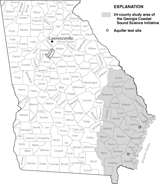
Production wells, monitoring network wells, and surface-water sites are shown in map A below. Examination of current (2003) and historical stream hydrograph data indicate streams are at baseflow conditions during late August. Therefore, streamflow measurements were made on August 28, 2003, along the Alcovy River and Cedar Creek to determine seepage (the gain or loss of water) in the vicinity of proposed future municipal wells (map B, below). Results from streamflow measurements indicate that streams generally gain water downstream; however, some stream reaches show a loss of streamflow and are considered as losing segments where discharge is less downstream than upstream. The reach showing the largest amount of gain because of ground-water discharge is between stations 02218046 and 02208047, which is one of the shortest reaches measured. From the confluence of the two rivers to the base of the watershed (station 02208050), the stream reach loses about 0.03 cubic feet per second (ft3/s). Ground-water levels in bedrock wells located next to streams (14FF59, 14FF62, and 14FF63) are consistently above stream stage, indicating a potential vertical gradient from the aquifer to the stream.
Rainfall produces peaks in both ground-water and stream-stage hydrographs. Conversely, periods of no rainfall produce recessions in both ground-water and stream-stage hydrographs. Minimum stream stage occurs in the Alcovy River during September, a period of little or no rainfall (graphs, facing page). The minimum ground-water level (for example, well 14FF52, a well located away from the Alcovy River), occurs during October. A downward gradient at the well cluster (14FF65 –14FF66) indicates potential recharge at this location. In addition, the rise in water levels indicates that storage increases during November and December.
![]() Precipitation and gage height at Alcovy River near Lawrenceville, Georgia (station 02208050), and ground-water levels at well cluster 14FF65 –14FF66 and well 14FF52 near Lawrenceville, Georgia, 2003 (locations shown on map, facing page; NAVD 88, North American Vertical Datum of 1988).
Precipitation and gage height at Alcovy River near Lawrenceville, Georgia (station 02208050), and ground-water levels at well cluster 14FF65 –14FF66 and well 14FF52 near Lawrenceville, Georgia, 2003 (locations shown on map, facing page; NAVD 88, North American Vertical Datum of 1988).
Production wells, monitoring network wells, and surface-water sites are shown in map A below. Seepage was calculated from discharge measurements taken on September 8, 2003, at six stations in the Redland– Pew Creek watershed (map B, below). These discharge measurements indicate that most stream reaches are gaining. The largest gaining reach was on Pew Creek (+2.40 ft3/s) from station 02205450 to 02205508. From the confluence of the two rivers to the base of the watershed the stream reach loses about 0.10 ft3/s. Ground-water levels in bedrock wells near streams (13FF14, 13FF18, and 13FF22) are consistently above the nearby stream stage, indicating a potential vertical gradient from the aquifer to streams at these locations.
As in the upper Alcovy River Watershed, precipitation in the Redland – Pew Creek watershed causes peaks in ground-water and stream-stage hydrographs. Stream-stage response to precipitation is flashy, meaning stream stage rises and falls in a relatively short period of time. Periods of low or no rainfall produce recessions in both ground-water and stream-stage hydrographs. Examination of the hydrographs (facing page) shows minimum stream stage occurs during late October and water levels in well cluster 13FF19 –13FF25 (cluster located on bank of Pew Creek) reach minimum levels in both wells during the same period.
Directly northwest of well cluster 13FF19 –13FF25 is well cluster 13FF31–13FF30. Water levels in this cluster receded throughout the end of 2003. The vertical gradient at this location is downward and indicates potential recharge in the area. In addition, the vertical gradient decreases through the end of the year. The ground-water-level trend is downward through November and December, indicating loss of storage at this location during that period, which is opposite of the gain in storage occurring in the upper Alcovy River watershed during this same period.
A downward vertical gradient also exists at well cluster 13FF27–13FF28; however, the vertical gradient changes over time. The potential vertical gradient decreases over time. The point at which the potential gradient is at a minimum occurs in December. Recharge occurs earlier here in the bedrock well than in the regolith well.
 Precipitation and gage height at Pew Creek at Patterson Road near Lawrenceville, Georgia (station 02205522); and ground-water levels at well clusters 13FF30–13FF31, 13FF27–13FF28, and 13FF19–13FF25 near Lawrenceville, Georgia, 2003 (well 13FF19 is a future production well; locations shown on map, facing page; NAVD 88, North American Vertical Datum of 1988).
Seasonal trends in precipitation, streamflow, and ground-water levels in well 14GG02 (map below) follow a similar pattern as those of the "production" watersheds. Precipitation causes a flashy stream response and periods of low or no precipitation cause periods of recession in streamflow. In well 14GG02, precipitation does not necessarily cause peaks in ground-water levels; drawdowns were caused by nearby irrigation (graphs, facing page).
The collection of streamflow, ground-water-level, seepage measurement, and climate data are necessary to provide the city of Lawrenceville a means to estimate the sustainability of the hydrologic system. The data collected during 2003, along with subsequent data collected during 2004 and 2005, will represent baseline conditions of the hydrologic system prior to the additional municipal well pumping scheduled to begin during 2005.
Precipitation causes almost instantaneous peaks in the hydrographs of stream stage for all three watersheds in the study area; periods of little or no precipitation produce periods of recession. Precipitation also causes a water-level rise in most wells being monitored except at well cluster 13FF30, 13FF31 and the control well 14GG02. This means that recharge, at some locations, infiltrates rapidly into the regolith.
Ground-water and streamflow data collected during 2003 indicate that seasonal trends in stream-stage and ground-water levels are similar in the three watersheds being monitored; however, minor differences exist when baseflow occurs in streams and when minimum water levels occur in wells. In the upper Alcovy River watershed, the lowest water levels in wells usually occur during October and the lowest stream-stage levels occur during late September. In the Redland–Pew Creek watershed, the lowest water levels in wells occur either during September, October, November, or December. Streamflow is lowest in Pew Creek during October. The water-level trend in well 14GG02 (control well) is downward from July through December and is affected by pumping.
Most well cluster water-level data indicate potential recharge to the igneous and metamorphic rock aquifer. This is evident in well clusters 13FF19 –13FF25 and 13FF30 –13FF31. Water-level data from well cluster 13FF19 –13FF25, located on the bank of Pew Creek, indicate a potential downward gradient; however, seepage data indicate this reach to be gaining. This apparent contradiction may indicate that (1) the stream is losing water in this short section next to the well cluster but gaining overall, (2) there is little connection between the stream and the aquifer at this location, and/or (3) only the regolith is contributing water to the stream in this area.
Seepage measurements generally indicate that streams are gaining during the baseflow period, meaning there is a net positive contribution of ground water to streamflow. This is important because annual seepage measurements will be monitored both before and after pumping begins, to observe the long-term effects of pumping on the ground-water contribution to streamflow. Water levels in most bedrock wells located near streams are consistently higher than streams, indicating a potential vertical gradient from the aquifer to streams. These vertical gradients show the potential for water to flow from the aquifer to streams; this water sustains streamflow in times of little precipitation. The data collected thus far in this study represent prepumping conditions in the hydrologic system and will be compared with data after pumping begins.
![]() Precipitation and gage height at Apalachee River at Fence Road near Dacula, Georgia (station 02218565); and ground-water levels in well 14GG02 near Lawrenceville, Georgia, 2003 (locations shown on map, facing page; NAVD 88, North American Vertical Datum of 1988).
Precipitation and gage height at Apalachee River at Fence Road near Dacula, Georgia (station 02218565); and ground-water levels in well 14GG02 near Lawrenceville, Georgia, 2003 (locations shown on map, facing page; NAVD 88, North American Vertical Datum of 1988).
Chapman, M.J., Crawford, T.J., and Tharpe, W.T., 1999, Geology and ground-water resources of the Lawrenceville area, Georgia: U.S. Geological Survey Water Resources Investigations Report 98-4233, 46 p.
Sauer, V.B., and Meyer, R.W., 1992, Determination of error in individual discharge measurements: U.S. Geological Survey Open-File Report 92-144, 21 p.
Willams, L.J., Albertson, P.N., Tucker, D.D., and Painter, J.A., 2004, Methods and hydrogeologic data from test drilling and geophysical logging surveys in the Lawrenceville, Georgia, area: U.S. Geological Survey Open-File Report 2004-1366, in press, CD – ROM.
Ground water in crystalline rocks underlying Rockdale County (map, below) and in other parts of the Georgia Piedmont has not been tapped extensively as a source of public drinking water. Such a source, however, may prove to be valuable to communities wishing to supplement their existing surface-water supplies and increase the amount of available drinking water in rapidly-growing areas of north Georgia. Understanding how ground water flows through crystalline rocks, where high-yielding water-bearing zones are present, and how much water is available, has been a focus of recent water-resource investigations being conducted by the U.S. Geological Survey (USGS) in cooperation with Rockdale County.
This technical highlight describes water-bearing characteristics of sheet fractures in Rockdale County. Sheet fractures have considerable influence on the availability of ground water in massive crystalline-rock geologic settings — particularly in the Lithonia Gneiss, which crops out in the northern part of Rockdale County. Water-bearing characteristics of sheet fractures penetrated at two well sites are discussed, and a photograph of one of these fractures in a local quarry is included.
To investigate the depth and nature of subsurface fractures, the open boreholes of wells were inspected with a downhole camera and an optical televiewer. The optical televiewer records oriented digital images of the borehole wall, thus allowing the strike and dip of intersecting fractures and structures to be measured. Flowmeter logs were collected to identify water-producing fracture zones in open boreholes. Water-producing zones yield measurable amounts of water to the borehole when pumped, or where water is flowing into the borehole during ambient conditions.
![]() (A) Location of Rockdale County, Georgia, and (B) selected high-yielding wells in Rockdale County.
(A) Location of Rockdale County, Georgia, and (B) selected high-yielding wells in Rockdale County.
Sheet fractures, also called stress-relief fractures (Cressler and others, 1983; Williams, 2003), are planar fractures that are thought to form from the upward expansion of the rock column in response to erosional unloading or from weather- ing. These fractures typically are characterized by sets of subhorizontal joints, are reported to be most numerous, and have higher water-bearing capacity near the surface because they become tighter and more widely spaced with increasing depth (Cressler and others, 1983). Because sheet fractures form roughly parallel to the land surface, the greatest water-bearing potential is in topographic positions that are favorable for intercepting recharge (diagram, facing page).
The water-bearing characteristics of sheet fractures were measured in two wells in Rockdale County. One well (13DD96) is located on a relatively steep slope on the west side of Honey Creek along Klondike Road (map, facing page). This 40-foot (ft) deep well penetrates a migmatitic granite gneiss that is characterized by swirled, weakly developed foliation. From the flowmeter log, the only water-bearing zone is a prominent sheet fracture at a depth of about 39 ft near the bottom of the well (images, below right). During pumping, the well yielded 6 gallons per minute (gal/min) from this fracture with approximately 1 ft of drawdown.
![]() Relative positions of wells tapping sheet fractures in nonlayered rock. Well A is in a topographically favorable position to intercept recharge; well B is in a topographically less favorable position (modified from McCollum, 1966).
Relative positions of wells tapping sheet fractures in nonlayered rock. Well A is in a topographically favorable position to intercept recharge; well B is in a topographically less favorable position (modified from McCollum, 1966).
![]() Topography and location of well 13DD96 along Klondike Road, Rockdale County, Georgia.
Topography and location of well 13DD96 along Klondike Road, Rockdale County, Georgia.
![]() Optical televiewer image of a sheet fracture in well 13DD96, Klondike Road, Rockdale County, Georgia. Image is oriented true north; cardinal directions are indicated at top of image. Inset shows a downhole view of the fracture (arrows) using a borehole camera.
Optical televiewer image of a sheet fracture in well 13DD96, Klondike Road, Rockdale County, Georgia. Image is oriented true north; cardinal directions are indicated at top of image. Inset shows a downhole view of the fracture (arrows) using a borehole camera.
Another well (13DD97) that derives most of its yield from sheet fractures is located on the floodplain of a small tributary that flows into the Yellow River (map, below). The Lithonia Gneiss — a massive granite gneiss — crops out throughout this area and is penetrated in this 297-ft-deep well. From the flowmeter log, several water-bearing zones were identified between 10 and 50 ft (facing page). Most of the water is derived from two subhorizontal fractures at depths of 29 ft and 23 ft, respectively. Using a pumping rate of 6 gal/min, the fracture at 29 ft produced about 0.3 gal/min and the fracture at 23 ft produced 5.1 gal/min. The remainder of the water (0.7 gal/min) is derived from fractures between 13.5 and 20 ft. No water is produced from the lower portion of the borehole below these sheet fractures.
Wells penetrating sheet fractures have a wide range in yield. Cressler and others (1983) reported a yield of 50 gal/min for a well tapping a horizontal stress-relief fracture at well 13DD90 (map, page 112). Yields of the two wells discussed in this highlight (13DD96 and 13DD97) are 55 and 45 gal/min, respectively.
![]() Topography and location of well 13DD97 along Irwin Bridge Road, Rockdale County, Georgia.
Topography and location of well 13DD97 along Irwin Bridge Road, Rockdale County, Georgia.
Sheet fractures are one of the most common type of fracture observed in rock outcrops and quarries in this area. These types of fractures appear to form as a result of spalling or exfoliation of bedrock sheets from the main bedrock exposure through the process of stress relief or weathering. One such fracture was observed in the Fletcher Quarry in northern Rockdale County (photographs, facing page). Photographs of sheet fractures in the Vulcan Quarry in eastern DeKalb County near the border with Rockdale County also were presented by Khallouf and Prowell (2003).
![]() Flowmeter and caliper logs for well 13DD97 along Irwin Bridge Road, Rockdale County, Georgia. (A) Ambient flowmeter log showing weak downward vertical flow, (B) pumping flowmeter log showing vertical flow in borehole while pumping 6 gallons per minute, and (C) caliper log showing peaks where the borehole diameter is enlarged at discrete fracture openings in the bedrock. Right-facing arrows indicate flow into borehole during pumping.
Flowmeter and caliper logs for well 13DD97 along Irwin Bridge Road, Rockdale County, Georgia. (A) Ambient flowmeter log showing weak downward vertical flow, (B) pumping flowmeter log showing vertical flow in borehole while pumping 6 gallons per minute, and (C) caliper log showing peaks where the borehole diameter is enlarged at discrete fracture openings in the bedrock. Right-facing arrows indicate flow into borehole during pumping.
Sheet fractures are an important source of water to several wells studied in Rockdale County. These near-surface water-bearing fractures form from spalling or exfoliation of rock sheets from the main bedrock exposure. Recharge probably occurs as a result of seepage from the overlying regolith, indicating that the best location to intercept these zones is in areas favoring recharge. Wells penetrating sheet fractures yield small to moderate amounts of water in quantities that are sufficient for single-household domestic use.
Further research is being conducted to investigate the occurrence and interconnectivity of water-bearing zones in Rockdale County. This study will help further water-resource managers' understanding of crystalline-rock aquifer systems and provide information needed for the development and management of ground-water resources in the Georgia Piedmont.
This study was conducted by the USGS in cooperation with Rockdale County. Many people were involved with helping make this study possible, including Lauri Ashmore, Director of Rockdale County Water Resources, Scott Emmons, Chief Engineer for Rockdale County Water Resources and the Rockdale County Board of Commissioners. Property owners willingly supplied information about their wells and allowed wells to be measured and sampled. Mr. Richard Morrison and Pastor Wayne Wilson allowed the USGS to obtain geophysical logs on the wells featured in this report. Johnny Robinson, Robinson Well Co., Monroe, Georgia, and Jerry Caldwell, Middle Georgia Water Systems, Zebulon, Georgia, furnished construction and yield data for numerous wells in Rockdale County.
Cressler, C.W., Thurmond, C.J., and Hester W.G., 1983, Ground Water in the Greater Atlanta Region, Georgia: Georgia Department of Natural Resources, Environmental Protection Division, Georgia Geologic Survey, Information Circular 63, 144 p.
Khallouf, D.D., and Prowell D.C., 2003, Description of water- bearing features in the Vulcan Materials Quarry, eastern DeKalb County, Georgia, in Williams, L.J., comp., Methods used to assess the occurrence and availability of ground water in fractured- crystalline bedrock: an excursion into areas of Lithonia Gneiss in eastern metropolitan Atlanta, Georgia: Georgia Geologic Survey Guidebook 23, p. 16 –24.
McCollum, M.J., 1966, Ground-Water Resources and Geology of Rockdale County, Georgia: Georgia State Division of Conservation, Department of Mines, Mining and Geology, Information Circular 33, 17 p.
Williams, L.J., 2003, Overview of geology, ground-water availability, and ground-water exploration and development in the greater Atlanta region, in Williams, L.J., comp., Methods used to assess the occurrence and availability of ground water in fractured- crystalline bedrock: an excursion into areas of Lithonia Gneiss in eastern metropolitan Atlanta, Georgia: Georgia Geologic Survey Guidebook 23, p. 4 –15.
The 24-county area of coastal Georgia is experiencing increasing demands on limited freshwater resources. To limit saltwater intrusion, the Georgia Department of Natural Resources, Georgia Environmental Protection Division (GaEPD) has restricted further development of the Upper Floridan aquifer— the principal source of water — in parts of the coastal area (Georgia Environmental Protection Division, 1997). The Georgia Coastal Sound Science Initiative is a series of scientific and feasibility studies to support development of the GaEPD final strategy to protect the Upper Floridan aquifer from saltwater contamination. As part of the Georgia Coastal Sound Science Initiative, the U.S. Geological Survey (USGS), in cooperation with the GaEPD, is developing numerical models to simulate ground-water flow and solute transport (saltwater contamination). These models will be used to evaluate water-management scenarios under various pumping conditions. To support this effort, ground- and surface-water-use data for 2000 were used to project future water demand for 2010, 2020, and 2035; these values were then compared to demand projections for 2010, 2020, and 2050 from county comprehensive water-supply plans.
The GaEPD defines the 24-county coastal area of Georgia to include the 6 coastal Georgia counties and 18 adjacent inland counties, an area encompassing about 12,240 square miles (map at right). The study area is located in the Coastal Plain physiographic province. Land use is largely urban in industrial areas and cities, such as Savannah and Brunswick; outside of these areas land use is a mix of forest, grazed woodland, cropland with pasture, marsh, and swampland. Topography ranges from flat in the coastal counties to relatively steep in northwestern parts of the area. Altitudes range from sea level along the coast to as high as 300 feet in the northwest.
![]() Twenty-four county coastal area with Regional Economic Models, Inc. (REMI) regions.
Twenty-four county coastal area with Regional Economic Models, Inc. (REMI) regions.
In the 24-county coastal area, projected future water use was estimated based on 2000 water-use data by county from the Aggregated Water-Use Data System (AWUDS) as developed by the Georgia Water-Use Program, a cooperative effort between the USGS and the GaEPD. The 2000 water-use data — the latest published data — were used as the basis for public supply, industrial, thermoelectric power, and agricultural water-use projections (Fanning, 2003).
The Regional Economic Models, Inc. (REMI) database was provided by Dr. Phyllis Isley and Jeremy Hill of the Bureau of Business Research and Economic Development at Georgia Southern University, Statesboro, Ga. REMI is a dynamic economic model built around regional market behaviors; the model is dynamic in that it includes various key econometric estimates with historical data that interact with each other. The REMI database includes annual county population projections for 2000 to 2035 for each of four REMI regions (regions 7, 9, 11, and 12) located within the 24-county coastal area (map, facing page). The REMI database also includes annual employment population (number of working people) projections by industry type for the same 35-year period. Although no water-demand projections are made by the REMI model, the employment population projections are useful for making estimates of future water demands. REMI regions 7, 9, and 11 extend beyond the coastal area; region 12 lies entirely within the coastal area.
Because there is a direct correlation between population change and the amount of water withdrawn for public supply, a population percent change was calculated for each year from 2001 to 2035 using the projected REMI regional population data for each of the four regions. This percent change was then applied to each of the 24 counties. The 2000 AWUDS estimate for public-supply water use — consisting of the sum of the public supply, domestic, and commercial water-use estimates — was increased by the calculated percent change in population to determine projected public-supply water use for selected years during 2001– 2035. Similarly, for industry, percentage change in the employment population for the 10 major industries in Georgia was used along with the AWUDS 2000 industry estimate to project industrial water-use demand for selected years during 2001–2035. This method similarly was applied to determine future thermoelectric-power use. These projections are herein referred to as USGS projections.
According to Kerry Harrison (Cooperative Extension Service, Tifton, Ga., oral commun., 2003), agricultural water use (irrigation water use) is expected to increase in the 24-county area at a rate of 5 percent every year through 2050. For the USGS projections, agricultural use was increased by this percentage per year.
A compilation of county Comprehensive Water-Supply Plans (CWSP) completed by Camp, Dresser & McKee, Inc. (2001) was developed as part of the Georgia Coastal Sound Science Initiative. The report summarizes historical, current, and projected population and water-demand information for the years 2010, 2020, and 2050 as derived from CWSP. Water demand was divided into categories of public supply (which includes domestic and commercial use), industry, and agriculture (irrigation).
As part of the Georgia Coastal Sound Science Initiative, the GaEPD provided an outline of requirements and suggested forecast techniques (DRI McGraw Hill model) to each county for developing their water-supply plans; however, a specific methodology was not prescribed (Napoleon Caldwell, Georgia Environmental Protection Division, oral commun., 2004). In the 24-county area, nine consulting firms and regional development centers were used to develop the plans. Thus, forecasting techniques included a variety of methods and models (Camp, Dresser, & McKee, Inc., 2001).
For 1980 – 97, the 24-county area showed a 6-percent increase in water use (Fanning, 1999). During the same period, the county populations increased about 28 percent. Population and public-supply water use are linked, that is, an increase in the number of people using public-supplied water will result in an increase in water use. In 2000, withdrawals were estimated at 922 million gallons per day (Mgal/d), with 536 Mgal/d from ground-water sources and 386 Mgal/d from surface-water sources.
Both the USGS and CWSP estimates showed an increase in water use in the 24-county area during 2001– 2035; however, projected increases vary between the methods. USGS estimates using REMI indicate water use will increase by about 130 Mgal/d (14 percent) by 2035 for a total use of 1,052 Mgal/d. By comparison, CWSP projections are about four times the USGS projections. According to CWSP data, water use during 2000 was 1,610 Mgal/d and is expected to be 2,160 Mgal/d by 2035, an increase of 550 Mgal/d (34 percent).
USGS projections for ground-water use (graph, page 118) show a steady increase of about 96 Mgal/d (25 percent) during the 35-year period from 2000 to 2035. In contrast, CWSP projections show an increase in ground-water use of nearly 485 Mgal/d (69 percent) during the same period, mostly for irrigation. Surface-water-use projections (graph, page 118) for USGS are more conservative than ground-water projections, with minor increases in each category of use. CWSP projections show large increases in industrial use (which includes thermoelectric-power use). Over the 35-year period, the total surface-water-use increases predicted by CWSP are 87 Mgal/d (10 percent) as compared to 34 Mgal/d (6 percent) by USGS.
![]() Projected water use by county in coastal Georgia for 2035 using the USGS and CWSP datasets.
Projected water use by county in coastal Georgia for 2035 using the USGS and CWSP datasets.
Water demand from USGS projections and CWSP for the year 2035 for each county in the 24-county area was compared (bottom graph, facing page). Five counties — Brantley, Charlton, Chatham, Screven, and Tattnall — have significant differences in projected use between the USGS and CWSP, most of which are because of a predicted increase in ground-water irrigation during the 35-year period. Chatham County increases include surface-water use for two thermoelectric power plants. Also, a cooling tower installed at Plant Mc-Manus in Glynn County purportedly will reduce thermo- electric-power water use to one-seventh of its previously reported use (Burns Wetherton, Georgia Power Company, oral commun., 2004). In most counties, the CWSP projec- tions exceed those of USGS.
During 2035, the counties showing the largest percentage of change from the USGS projections are Bryan, McIntosh, Long, Wayne, Brantley, and Charlton (graph below). The CWSP projections show Bryan, Tattnall, Screven, McIntosh, Jenkins, and Ware as the counties with the largest percentage change during 2035.
Camp Dresser & McKee, Inc., September, 2001, Southeast Georgia 24-county area water supply services, alternative sources to groundwater supply report, CD – ROM-2.
Fanning, J.L., 1999, Water use in coastal Georgia by county and source, 1997; and water-use trends, 1980 –1997: Georgia Geologic Survey Information Circular 104, 37 p.
Fanning, J.L., 2003, Water use in Georgia by county for 2000 and water-use trends for 1980 – 2000: Georgia Geologic Survey Information Circular 106, 176 p.
Georgia Environmental Protection Division, 1997, Interim strategy for managing saltwater intrusion in the Upper Floridan aquifer of southeast Georgia, April 23, 1997: Atlanta, Ga., Georgia Environmental Protection Division, 19 p.
Back to the Table of Contents
Recent USGS publications on Georgia or Georgia Water-Resources Information
 Drawdown and recovery in wells observed during aquifer test of the lower Brunswick aquifer, Old Sunbury Road test site, Liberty County, Georgia, January 2003.
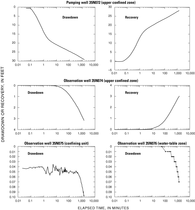 Drawdown and recovery in wells observed during aquifer test of the upper confined zone of the surficial aquifer, Old Sunbury Road test site, Liberty County, Georgia, February 2003.