U.S. Geological Survey Scientific Investigations Report 2005-5065
Back to the Table of Contents
Reliable and impartial scientific information on the occurrence, quantity, quality, distribution, and movement of water is essential to resource managers, planners, and others throughout the Nation. The U.S. Geological Survey (USGS) — in cooperation with numerous local, State, and Federal agencies—collects hydrologic data and conducts studies to monitor hydrologic conditions and better define the water resources of Georgia and other States and territories.
Ground-water-level and ground-water-quality data are essential for water-resource assessment and management. Water-level measurements from observation wells are the principal source of information about the hydrologic stresses on aquifers and how these stresses affect ground-water recharge, storage, and discharge. Long-term, systematic measurements of water levels provide essential data needed to evaluate changes in the resource over time, develop ground-water models and forecast trends, and design, implement, and monitor the effectiveness of ground-water management and protection programs (Taylor and Alley, 2001). Ground-water-quality data are necessary for the protection of ground-water resources because deterior-ation of ground-water quality may be virtually irreversible, and treatment of contaminated ground water can be expensive (Alley, 1993). Reliable water-use data are important to many organizations and individuals in support of research and policy decisions, and as an essential part of understanding the effects of humans on the hydrologic system (Hutson and others, 2004).
This report presents an overview of ground-water conditions, water-use information, and hydrologic studies conducted during 2002 and 2003 by the USGS in Georgia. Summaries of selected ground-water studies, with objectives and progress, and selected technical highlights are presented. These summaries and highlights include:
Periodic water-level measurements were taken in 870 wells, and continuous water-level measurements were obtained from 185 wells during 2002 and 177 wells during 2003 (however, only data from 155 wells are summarized herein). Of the 177 wells equipped with continuous water-level recorders during 2003, 159 wells had electronic data recorders, which recorded the water level at 60-minute intervals with these data generally retrieved monthly. Eighteen wells had real-time satellite telemetry, which recorded the water level at 60-minute intervals and transmitted water levels every 4 hours for display on the USGS Georgia District Web site at http://water.usgs.gov/ga/nwis/current?type=gw
Median-annual water levels for 2003 were compared with the normal range of ground-water levels for the period of record; the results of this comparison are shown on maps for selected aquifers and areas of the State. In addition, hydrographs showing monthly mean ground-water levels for the period 1999 – 2003 are shown with period-of-record water-level statistics for selected wells.
Periodic water-level measurements in the Upper Floridan aquifer were collected during October 2002 and September 2003 in 68 wells in south-central Dougherty County near Albany, and maps showing the potentiometric surface of the aquifer were constructed from these data. A similar map of the Upper Floridan aquifer was constructed for Camden, Charlton, and Ware Counties and adjacent counties in Florida using water-level measurements collected during September 2003 from 52 wells (Kinnaman and Knowles, 2004).
Previous reports on ground-water conditions in Georgia
| Year of data collection | USGS report series and number | Author(s) | Year of publication |
|---|---|---|---|
| 1977 | 1OFR 79-213 | U.S. Geological Survey | 1978 |
| 1978 | OFR 79-1290 | Clarke, J.S., Hester, W.G., and O'Byrne, M.P. | 1979 |
| 1979 | OFR 80-501 | Mathews, S.E., Hester, W.G., and O'Byrne, M.P. | 1980 |
| 1980 | OFR 81-1068 | Mathews, S.E., Hester, W.G., and O'Byrne, M.P. | 1981 |
| 1981 | OFR 82-904 | Mathews, S.E., Hester, W.G., and McFadden, K.W. | 1982 |
| 1982 | OFR 83-678 | Stiles, H.R., and Mathews, S.E. | 1983 |
| 1983 | OFR 84-605 | Clarke, J.S., Peck, M.F., Longsworth, S.A., and McFadden, K.W. | 1984 |
| 1984 | OFR 85-331 | Clarke, J.S., Longsworth, S.A., McFadden, K.W., and Peck, M.F. | 1985 |
| 1985 | OFR 86-304 | Clarke, J.S., Joiner, C.N., Longsworth, S.A., McFadden, K.W., and Peck, M.F. | 1986 |
| 1986 | OFR 87-376 | Clarke, J.S., Longsworth, S.A., Joiner, C.N., Peck, M.F., McFadden, K.W., and Milby, B.J. | 1987 |
| 1987 | OFR 88-323 | Joiner, C.N., Reynolds, M.S., Stayton, W.L., and Boucher, F.G. | 1988 |
| 1988 | OFR 89-408 | Joiner, C.N., Peck, M.F., Reynolds, M.S., and Stayton, W.L. | 1989 |
| 1989 | OFR 90-706 | Peck, M.F., Joiner, C.N., Clarke, J.S., and Cressler, A.M. | 1990 |
| 1990 | OFR 91-486 | Milby, B.J., Joiner, C.N., Cressler, A.M., and West, C.T. | 1991 |
| 1991 | OFR 92-470 | Peck, M.F., Joiner, C.N., and Cressler, A.M. | 1992 |
| 1992 | OFR 93-358 | Peck, M.F., and Cressler, A.M. | 1993 |
| 1993 | OFR 94-118 | Joiner, C.N., and Cressler, A.M. | 1994 |
| 1994 | OFR 95-302 | Cressler, A.M., Jones, L.E., and Joiner, C.N. | 1995 |
| 1995 | OFR 96-200 | Cressler, A.M. | 1996 |
| 1996 | OFR 97-192 | Cressler, A.M. | 1997 |
| 1997 | OFR 98-172 | Cressler, A.M. | 1998 |
| 1998 | OFR 99-204 | Cressler, A.M. | 1999 |
| 1999 | OFR 00-151 | Cressler, A.M. | 2000 |
| 2000 | OFR 01-220 | Cressler, A.M., Blackburn, D.K., and McSwain, K.B. | 2001 |
| 2001 | 2WRIR 03-4032 | Leeth, D.C., Clarke, J.S., and Craigg, S.D., and Wipperfurth, C.J. | 2003 |
1OFR, Open-File Report; 2WRIR, Water-Resources Investigations Report
Chloride concentrations in water collected from the Upper and Lower Floridan aquifers are shown in graphs for five wells in the city of Brunswick area and six wells in the Camden County area. Maps were constructed showing the chloride concentrations in water from the upper water-bearing zone of the Upper Floridan aquifer at Brunswick for June 2002 using data from 43 wells and for June 2003 using data from 56 wells. Nitrate concentrations in water from the Upper Floridan aquifer were analyzed for 12 wells using November 2002 data, for 4 wells and one stream using May 2003 data, and for 14 wells and one stream using 2003 data in south-central Dougherty County near Albany.
In the city of Savannah area, a combination of fluid resistivity logs and collection of depth-dependent "grab" samples have supplanted the more traditional water-quality collection method of purging and sampling a well as is done in Brunswick and Camden County. In Savannah, four wells were assessed during December 2003 using this technique.
Water-use data compiled for 1999 – 2003, and reported herein, are based on State-mandated reporting requirements for water users withdrawing more than 100,000 gallons per day (gal/d). State-mandated reporting includes data for public supply, industrial and commercial, and thermoelectric-power water use; however, reporting of information on irrigation water use is not mandated and, therefore, not discussed in this report.
Hydrographs from selected wells are presented herein to compare 5-year trends and seasonal fluctuations to period-of-record statistics in major aquifers throughout the State. A more complete listing of water-level data from USGS continuously monitored wells is provided in the CD – ROM reports, "Contin-uous ground-water-level data, and periodic surface-water- and ground-water-quality data, calendar year 2002" (Coffin and others, 2003) and "Continuous ground-water-level data, and periodic surface-water- and ground-water-quality data, calendar year 2003" (Coffin and others, 2004). Those reports include annual and period-of-record ground-water-level hydrographs, summary statistics (maximum, minimum, and mean), and well information (construction and location). Additional well information can be obtained from the USGS National Water Information System (NWIS) at http://waterdata.usgs.gov/ga/nwis/gw
Median water levels for 2003 were compared to period-of-record normal water levels to determine if water levels were above normal, below normal, or normal. In this report, the normal range is defined as those water-level observations during the calendar year that lie between the 25th and 75th percentiles (first and third quartiles), also known as the inter-quartile range, for the period of record. The 75th percentile (third quartile) means that three-quarters of the observations lie below it; the 25th percentile (first quartile) means that one-quarter of the observations lie below it, and the median or 50th percentile (second quartile) means that two-quarters (one-half) of the observations lie below it and two-quarters (one-half) of the observations lie above it (Hamburg, 1985). This can be shown by examining a graphical representation of these values known as a boxplot (Tukey, 1977) (below left).
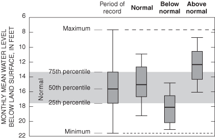 Boxplot depicting the method used to determine if 2003 water levels in a well were within, below, or above the normal range. If the median (50th per- centile) water level for 2003 was between the 25th and 75th percentiles of period-of-record water levels, then water levels in the well were considered
normal. If the median water level for 2003 was below the 25th percentile, then water levels in the well were considered below normal. If the median water level for 2003 was above the 75th percentile, then water levels were considered above normal.
Boxplot depicting the method used to determine if 2003 water levels in a well were within, below, or above the normal range. If the median (50th per- centile) water level for 2003 was between the 25th and 75th percentiles of period-of-record water levels, then water levels in the well were considered
normal. If the median water level for 2003 was below the 25th percentile, then water levels in the well were considered below normal. If the median water level for 2003 was above the 75th percentile, then water levels were considered above normal.
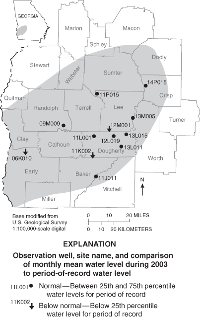
The results of this comparison are graphically represented on maps in the ground-water-level section of this report (map below, for example) either by an up arrow—2003 monthly mean water levels above period-of-record normal values; a down arrow—2003 monthly mean water levels below the normal range for the period of record; or a circle—2003 monthly mean water levels within the normal range for the period of record.
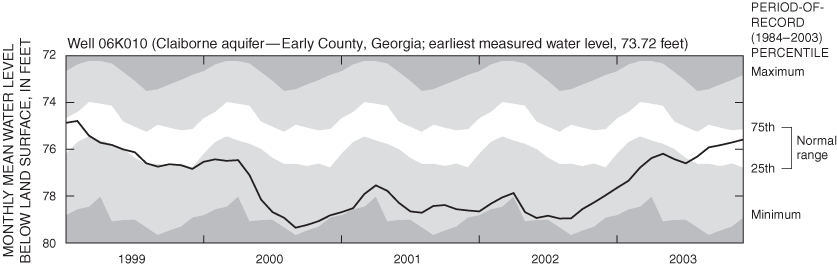
Data showing monthly mean ground-water levels during 1999 – 2003 were plotted together with data showing period-of-record water-level statistics (monthly mean normal, minimum, and maximum water levels) (hydrograph below). The period-of-record monthly statistics were calculated through December 2002 and are repeated on the graphs for 1999, 2000, 2001, 2002 and 2003. For example, statistics for the month of June are the same on the plots for each year during 1999 – 2003. Land-surface altitude for most wells was determined from topographic maps and is accurate to about one-half the contour interval (usually from 2.5 to 5 feet). Some land-surface altitudes were determined by surveying methods or Global Positioning System (GPS) and are more accurate.
Water samples were analyzed for nitrate at the USGS laboratory in Ocala, Florida. Chloride analyses were conducted at the USGS Ocala laboratory, at the USGS Atlanta, Georgia, laboratory, and at the St. Johns River Water Management District in Palatka, Florida (for Camden County). Additional water-quality data for Georgia can be obtained from the USGS National Water Information System (NWIS) at http://waterdata.usgs.gov/ga/nwis/qw
The Georgia Water-Use Program (GWUP), a cooperative project between the USGS and the Georgia Department of Natural Resources, Environmental Protection Division, has documented the use of water in the State since 1977. Water-use data — compiled by various Federal, State, and local agencies — are combined into a centralized database known as the Georgia Water-Use Data System (GWUDS). GWUDS contains permitted water-use information on public supplies, industrial and commercial supplies, and thermoelectric-power and hydroelectric-power uses from 1980 –2003. Georgia water law requires a withdrawal permit for all public-supply, industrial, and other water users who withdraw more than 100,000 gal/d, an exception to this requirement is for irrigation water. During 1988, the Georgia Legislature enacted a permitting law for irrigation water users who withdraw more than 100,000 gal/d of water, but the reporting of water withdrawal is not required.
Wells described in this report are given a well name according to a system based on the USGS index of topographic maps of Georgia. Each 7½-minute topographic quadrangle in the State has been assigned a three- to four-digit number and letter designation (for example, 07H or 11AA) beginning at the southwestern corner of the State. Numbers increase sequentially eastward, and letters advance alphabetically northward. Quadrangles in the northern part of the State are designated by double letters: AA follows Z, and so forth. The letters "I," "O," "II," and "OO" are not used. Wells inventoried in each quadrangle are numbered consecutively, beginning with 01. Thus, the fourth well inventoried in the 11AA quadrangle is designated 11AA04. In the USGS NWIS database, this information is stored under the field "Well Name."
Ground-water monitoring and hydrologic studies in Georgia are conducted in cooperation with numerous local, State, and Federal organizations. Cooperating organizations include:
With the exception of the Federal agencies, all of these organizations participate in the USGS Cooperative Water Program, an ongoing partnership between the USGS and non-Federal agencies. The program enables joint planning and funding for systematic studies of water quantity, quality, and use. Data obtained from these studies are used to guide water-resources management and planning activities and provide indications of emerging water problems. For a more complete description of the Cooperative Water Program, see Brooks (2001).
Alley, W.M., 1993, General design consideration, in Alley, W.M. (editor), Regional ground-water quality: Van Nostrand Reinhold, New York, N.Y., 634 p.
Brooks, M.H., 2001, Cooperative water program — A partnership in the Nation's Water-Resources Program: U.S. Geological Survey Fact Sheet 128-01, 2 p.
Coffin, Robert, Grams, S.C., Leeth, D.C., and Peck, M.F. 2003, Continuous ground-water-level data, and periodic surface-water- and ground-water-quality data, calendar year 2002, v. 2, in Alhadeff, S.J., and McCallum, B.E. (compilers), Water resources data–Georgia, 2002: U.S. Geological Survey Water-Data Report GA-02-2, CD–ROM.
Coffin, Robert, Grams, S.C., Peck, M.F., and Cressler, A.M., 2004, Continuous ground-water-level data, and periodic surface-water- and ground-water-quality data, calendar year 2003, v. 2, in Alhadeff, S.J., and McCallum, B.E. (compilers), Water resources data – Georgia, 2003: U.S. Geological Survey Water-Data Report GA-03-2, CD–ROM.
Hamburg, Morris, 1985, Basic statistics: Harcourt, Brace, Jovanovich, Atlanta, 548 p.
Hutson, S.S., Barber, N.L., Kenny, J.F., Linsey, K.S., Lumia, D.S., and Maupin, M.A., 2004, Estimated use of water in the United States in 2000: U.S. Geological Survey Circular 1268, 46 p.
Kinnaman, S.L., and Knowles, Leel, Jr., 2004, Potentiometric surface of the Upper Floridan aquifer in the St. Johns River Water Management District, and vicinity, Florida, Sept. 2003: U.S. Geological Survey Open-File Report 04-1288, 1 map.
Taylor, C.J., and Alley, W.M., 2001, Ground-water-level monitoring and the importance of long-term water level data: U.S. Geological Survey Circular 1217, 68 p.
Tukey, J.W., 1977, Exploratory data analysis: Addison-Wesley Pub., Reading, Mass., 506 p.
Contrasting geologic features and landforms of the physiographic provinces of Georgia (map, facing page; table, pages 10 and 11) affect the quantity and quality of ground water throughout the State. The surficial aquifer system is present in each of the physiographic provinces. In the Coastal Plain Province, the surficial aquifer system consists of intermixed layers of sand, clay, and limestone. The surficial aquifer system usually is under water-table (unconfined) conditions and is used for domestic and livestock supplies. The surficial aquifer system is semiconfined to confined locally in the coastal area. In the Piedmont, Blue Ridge, and Valley and Ridge Provinces, the surficial aquifer system consists of soil, saprolite, stream alluvium, colluvium, and other surficial deposits.
The most productive aquifers in Georgia are in the Coastal Plain Province in the southern half of the State. The Coastal Plain is underlain by alternating layers of sand, clay, dolomite, and limestone that dip and thicken to the southeast. Coastal Plain aquifers generally are confined, except near their northern limits where they crop out or are near land surface. Aquifers in the Coastal Plain include the surficial aquifer system, Brunswick aquifer system, Upper and Lower Floridan aquifers, Gordon aquifer system, Claiborne aquifer, Clayton aquifer, and Cretaceous aquifer system.
In the Valley and Ridge Province, ground water is transmitted through primary and secondary openings in folded and faulted sedimentary and metasedimentary rocks of Paleozoic age, herein referred to as "Paleozoic-rock aquifers."
In the Piedmont and Blue Ridge Provinces, the geology is complex and consists of structurally deformed metamorphic and igneous rocks. Ground water is transmitted through secondary openings along fractures, foliation, joints, contacts, or other features in the crystalline bedrock. In these provinces, aquifers are referred to as "crystalline-rock aquifers." For a more complete discussion of the State's ground-water resources, see Clarke and Pierce (1984).
| Aquifer name | Aquifer description | Well characteristics | Hydrologic response | Remarks | ||
|---|---|---|---|---|---|---|
| Depth (ft) | Yield (gal/min) | |||||
| Typical range | Typical range | May exceed | ||||
| Surficial aquifer system | Unconsolidated sediments and residuum; generally unconfined. However, in the coastal area of the Coastal Plain, at least two semiconfined aquifers have been identified | 11– 300 | 2 – 25 | 75 | Water-level fluctuations mainly are caused by variations in precipitation, evapotranspiration, and natural drainage. In addition, water levels in the city of Brunswick area are influenced by nearby pumping, precip- itation, and tidal fluctuations (Clarke and others, 1990). Water levels generally rise rapidly during wet periods and decline slowly during dry periods. Prolonged droughts may cause water levels to decline below pump intakes in shallow wells, particularly those located on hilltops and steep slopes, resulting in temporary well failures. Usually, well yields are restored by precipitation (Clarke, 2003). | Primary source of water for domestic and livestock supply in rural areas. Supplemental source of water for irrigation supply in coastal Georgia. |
| Brunswick aquifer system, including upper and lower Brunswick aquifers | Phosphatic and dolomitic quartz sand; generally confined | 85 – 390 | 10 – 30 | 180 | In the coastal area, the aquifers may respond to pumping from the Upper Floridan aquifer as a result of the hydraulic connection between the aquifers. Elsewhere the water level mainly responds to seasonal variations in recharge and discharge. In Bulloch County, unnamed aquifers equivalent to the upper and lower Brunswick aquifers are unconfined to semiconfined and are influenced by variations in recharge from precipitation and by pumping from the Upper Floridan aquifer; in the Wayne and Glynn County area, the aquifers are confined and respond to nearby pumping (Clarke and others, 1990; Clarke, 2003). | Not a major source of water in coastal Georgia, but considered a supplemental water supply to the Upper Floridan aquifer. |
| Upper and Lower Floridan aquifers | Limestone, dolomite, and calcareous sand; generally confined | 40 – 900 | 1,000 – 5,000 | 11,000 | In and near outcrop areas, the aquifers are semiconfined and water levels in wells tapping the aquifers fluctuate seasonally in response to varia-tions in recharge rate and pumping. Near the coast, where the aquifers are confined, water levels primarily respond to pumping, and fluctuations related to recharge are less pronounced (Clarke and others, 1990). | Supplies about 50 percent of ground water in Georgia. The aquifer system is divided into the Upper and Lower Floridan aquifers. In the Brunswick area, the Upper Floridan aquifer includes two freshwater-bearing zones, the upper water-bearing zone and the lower water-bearing zone The Lower Floridan aquifer is not considered a major aquifer. In the Brunswick area and in southeastern Georgia, the Lower Floridan aquifer includes the brackish-water zone, the deep freshwater zone, and the Fernandina permeable zone (Krause and Randolph, 1989). The Lower Floridan aquifer extends to more than 2,700 ft deep and yields high-chloride water below 2,300 ft (Jones and Maslia, 1994). |
| Gordon aquifer system | Sand and sandy limestone; generally confined | 270–530 | 87–1,200 | 1,800 | Water levels are influenced by seasonal fluctuations in recharge from precipitation, discharge to streams, and evapotranspiration (Clarke and others, 1985). | Major source of water for irrigation, industrial, and public- supply use in east-central Georgia. |
| Claiborne aquifer | Sand and sandy limestone; generally confined | 20–450 | 150–600 | 1,500 | Water levels mainly are affected by precipitation and by local and regional pumping (Hicks and others, 1981). The water level is generally highest following the winter and spring rainy seasons, and lowest in the fall following the summer irrigation season. | Major source of water for irrigation, industrial, and public-supply use in southwestern Georgia. |
| Clayton aquifer | Limestone and sand generally confined; | 40 – 800 | 250 – 600 | 2,150 | Water levels are affected by seasonal variations in local and regional pumping (Hicks and others, 1981). | Major source of water for irrigation, industrial, and public- supply use in southwestern Georgia. |
| Cretaceous aquifer system | Sand and gravel; generally confined | 30 –750 | 50 –1,200 | 3,300 | Water levels are influenced by variations in precipitation and pumping (Clarke and others, 1983, 1985). | Major source of water in east-central Georgia. Supplies water for kaolin mining and processing. Includes the Providence aquifer in southwestern Georgia, and the Dublin, Midville, and Dublin–Midville aquifer systems in east-central Georgia. |
| Paleozoic-rock aquifers | Sandstone, limestone and dolomite; generally confined | 15 –2,100 | 1– 50 | 3,500 | Water levels mainly are affected by precipitation and local pumping (Cressler, 1964). | Not laterally extensive. Limestone and dolomite aquifers are most productive. Storage is in regolith, primary openings, and secondary fractures and solution openings in rock. Springs in limestone and dolomite aquifers discharge at rates of as much as 5,000 gal/min. Sinkholes may form in areas of intensive pumping. |
| Crystalline-rock aquifers | Granite, gneiss, schist, and quartzite; generally confined | 40 – 600 | 1– 25 | 500 | Water levels mainly are affected by precipitation and evapotranspiration, and locally by pumping (Cressler and others, 1983). Precipitation can cause a rapid rise in water levels in wells tapping aquifers overlain by thin regolith. | Storage is in regolith and fractures in rock. |
Clarke, J.S., 2003, The surficial and Brunswick aquifer systems — alternative ground-water resources for coastal Georgia, in Hatcher, K.J. (editor), Proceedings of the 2003 Georgia Water Resources Conference, April 23–24, 2003, University of Georgia, CD–ROM.
Clarke, J.S., Brooks, Rebekah, and Faye, R.E., 1985, Hydrology of the Dublin and Midville aquifer system of east-central Georgia: Georgia Geologic Survey Information Circular 74, 62 p.
Clarke, J.S., Faye, R.E., and Brooks, Rebekah, 1983, Hydro-geology of the Providence aquifer of southwest Georgia: Georgia Geologic Survey Hydrologic Atlas 11, 5 sheets.
Clarke, J.S., Hacke, C.M., and Peck, M.F., 1990, Geology and ground-water resources of the coastal area of Georgia: Georgia Geologic Survey Bulletin 113, 106 p.
Clarke, J.S., and Pierce, R.R., 1984, Georgia ground-water resources, in U.S. Geological Survey, National Water Summary 1984: U.S. Geological Survey Water-Supply Paper 2275, p. 179–184.
Cressler, C.W., 1964, Geology and ground-water resources of Walker County, Georgia: Georgia Geologic Survey Information Circular 29, 15 p.
Cressler, C.W., Thurmond, C.J., and Hester, W.G., 1983, Ground water in the greater Atlanta region, Georgia: Georgia Geologic Survey Information Circular 63, 144 p.
Hicks, D.W., Krause, R.E., and Clarke, J.S., 1981, Geohydrology of the Albany area, Georgia: Georgia Geologic Survey Information Circular 57, 31 p.
Jones, L.E., and Maslia, M.L., 1994, Selected ground-water data, and results of aquifer tests for the Upper Floridan aquifer, Brunswick, Glynn County, Georgia, area: U.S. Geological Survey Open-File Report 94-520, 107 p.
Krause, R.E., and Randolph, R.B., 1989, Hydrogeology of the Floridan aquifer system in southeast Georgia and adjacent parts of Florida and South Carolina: U.S. Geological Survey Professional Paper 1403-D, 65 p.
Peck, M.F., Joiner, C.N., and Cressler, A.M., 1992, Ground-water conditions in Georgia, 1991: U.S. Geological Survey Open-File Report 92-470, 137 p.
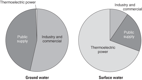
When complete water-use data are not available, permitted water-use data can be used to assess impacts of ground-water withdrawal on ground-water systems. Because data from every water-use category are only compiled by the U.S. Geological Survey every 5 years, only water-use data from permitted water systems are included in this report. More specifically, estimates for irrigation and domestic supply are not included herein. During 2003, permitted withdrawal by public-supply systems totaled about 1,120 million gallons per day (Mgal/d), of which about 80 percent was from surface-water sources and 20 percent from ground-water sources (pie chart, below). Permitted withdrawals by industrial and commercial users totaled about 670 Mgal/d, of which 62 percent was from surface-water sources and 38 percent was from ground-water sources. The major industrial users in Georgia include paper, textiles, chemicals, stone and clay, and mining.
To understand the areal distribution and trends of permitted ground-water withdrawal, data were grouped into five physiographic provinces of the State and are depicted from 1999 – 2003 (map and barcharts, facing page). In general, permitted ground-water withdrawal has decreased across the State since 1999; the only exception to this was in the Piedmont and Blue Ridge. This decrease largely is a result of conservation efforts made by industrial and municipal users. In the Coastal Plain, permitted ground-water use generally decreased during 1999–2003. In the eastern Coastal Plain, the decrease was about 42.3 Mgal/d (about 54.3 Mgal/d from 2000 to 2003), mostly because of plant closings and reduction in industrial withdrawals. In the central Coastal Plain, the decrease was about 24.6 Mgal/d, and in the southwest Coastal Plain the decrease was about 4 Mgal/d. In the Valley and Ridge area, withdrawal decreased about 0.5 Mgal/d during 1999 – 2003. Unlike the rest of the State, permitted ground-water withdrawal in the Piedmont and Blue Ridge increased by about 1.4 Mgal/d from 1999 to 2003. Peak ground-water usage in this area occurred during 2002 when the increase from 1999 was about 2.3 Mgal/d.
Percentage of permitted water use in Georgia by category and source, 2003.
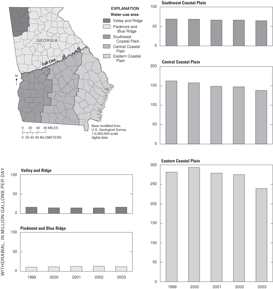
Ground-water withdrawal in Georgia by water-use area, 1999–2003.
Back to the Table of Contents
Recent USGS publications on Georgia or Georgia Water-Resources Information