U.S. Geological Survey Scientific Investigations Report 2005-5136, 43 pages (Published September 2005) ONLINE ONLY
 Obtaining large quantities of ground water needed for municipal and industrial supply in the Piedmont and Blue Ridge physiographic provinces can be challenging because of the complex geology and the typically low primary permeability of igneous and metamorphic rocks. Areas of enhanced secondary permeability in the bedrock do occur, however, and “high-yield” wells are not uncommon, particularly where careful site-selection techniques are used prior to test drilling. The U.S. Geological Survey — in cooperation with the City of Lawrenceville, Georgia — conducted this study from 2000 to 2002 to learn more about how different geologic settings influence the availability of ground water in igneous and metamorphic bedrock with the expectation that this knowledge could be used to help identify additional water resources in the area.
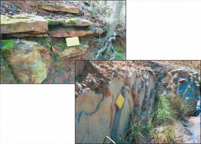
In compositionally layered-rock settings, wells derive water almost exclusively from lithologically and structurally controlled water-bearing zones formed parallel to foliation and compositional layering. These high-permeability, water-bearing zones — termed foliation-parallel parting systems —combined with high-angle joint systems, are the primary control for the high-yield wells drilled in the Lawrenceville area; yields range from 100 to several hundred gallons per minute (gal/min). Near Lawrenceville, areas with high ground-water yield are present in sequences of amphibolite, biotite gneiss, and button schist where the structural attitude of the rocks is gently dipping, in areas characterized by abundant jointing, and in topographic settings with a continuous source of recharge along these structures.
In massive-rock settings, wells derive water mostly from joint systems, although foliation-parallel parting systems also may be important. Wells deriving water primarily from steeply-dipping joint systems typically have low yields ranging from 1 to 5 gal/min. Joint systems in massive-rock settings can be identified and characterized by using many of the methods described in this report. Geologic mapping was the primary method used to determine the distribution, variability, and relative concentrations (intensity) of joint systems. In the subsurface, joints were characterized by taking orientation measurements in the open boreholes of wells using acoustic and/or optical televiewers.
In this investigation, the only practical approach found for locating areas of high ground-water potential was first through detailed geologic mapping followed by test drilling, borehole geophysical logging, and aquifer testing. Geologic methods help characterize both large- and small-scale structures and other lithologic and stratigraphic features that influence development of increased secondary permeability in the bedrock. The rock types, discontinuities, depth of weathering, topographic position, and recharge potential — which were the principal factors assessed through detailed geologic mapping — must be evaluated carefully, in relation to one another, to assess the ground-water potential in a given area.
Abstract
Introduction
Purpose and Scope
Methods of Study
Previous Studies
Acknowledgments
Description of the Study Area
Water Use
Geologic Setting
Hydrogeologic Setting
Recharge and Regolith/Bedrock Storage Capability
Water-Bearing Zones
Influence of Geologic Setting on Ground-Water Availability
Geologic Factors
Compositionally Layered-Rock Settings
Example of a Productive Well (14FF59) in a Compositionally Layered-Rock Setting
Examples of Other Wells in Compositionally Layered-Rock Settings
Aquifer Tests of Productive Wells in Compositionally Layered-Rock Settings
Influence of Joint Systems
Conceptual Model of Ground-Water Availability
Methods for Identifying and Characterizing Foliation-Parallel Parting Systems
Massive-Rock Settings
Example of a Well (14FF58) in a Massive-Rock Setting
Other Wells in Massive-Rock Settings
Conceptual Model of Ground-Water Availability
Methods for Identifying and Characterizing Joint Systems
Potential for Future Ground-Water Development
Summary and Conclusions
References Cited
1 U.S. Geological Survey, Atlanta, Ga.
2 Associate Professor, University of West Georgia, Carrollton, Ga.
3 Professor Emeritus, University of West Georgia, Carrollton, Ga.
4 U.S. Geological Survey, Raleigh, N.C.
This report is available online in pdf format:
Scientific Investigations Report 2005-5136 (5.9 MB)
To view this document, you need the Adobe Acrobat® Reader installed on
your computer. (A free
copy of the Acrobat® Reader may be downloaded from Adobe Systems
Incorporated.)
Recent USGS publications on Georgia or Georgia Water-Resources Information
For more information, please contact webmaster-ga@usgs.gov .
| AccessibilityFOIAPrivacyPolicies and Notices | |
 |
|