 |
|
|
||||
| Florida Science Center |
SIR 2005-5233
Prepared in cooperation with
Jacksonville Electric Authority
St. Johns River Water Management District
2006
 |
Select an option: |
|
CONTENTS Abstract Introduction Purpose and Scope Hydrogeologic Framework Hydrogeology of Duval County Well Field Previous Studies Acknowledgments Description of MODOPTIM Parameters Used to Generate MODOPTIM Input Files MODOPTIM Output Files Aquifer-Parameter Sensitivity and Non-Uniqueness of Solution Application of Aquifer-Test Preprocessor for MODOPTIM Use of Aquifer-Test Preprocessor Analysis of Aquifer-Test Data From Well Field in Duval County, Florida Comparison Between MODOPTIM and Analytically-Derived Values Limitations and Advantages of MODOPTIM Summary and Conclusions References Appendix A. Input Structures Used in MODOPTIM Files Appendix B. Input for Main Optimization File Appendix C. Input for Composite MODFLOW/MODOPTIM File with Parameters to be Estimated Appendix D. Input for Grid Discretization File |
A method was developed to generate the input files needed to compute the hydraulic properties from
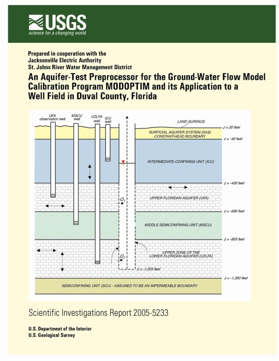
aquifer-performance test data for confined aquifers (such as the Floridan aquifer system) by using an aquifer-test preprocessor for the computer program MODOPTIM. MODOPTIM is a non-linear, ground-water flow model calibration and management tool that uses MODFLOW-96 to simulate cylindrical or axisymmetric flow in the vicinity of a pumping well for any aquifer-well configuration. The preprocessor assumes that the production well penetrates either the Upper
Floridan aquifer only, or penetrates both the Upper Floridan aquifer and Lower Floridan aquifer. The production well may fully or partially penetrate either aquifer. Input files needed to run MODOPTIM are
generated by the aquifer-test preprocessor and the optimal hydraulic parameter values are computed by running MODOPTIM, which determines the set of parameter values that minimizes the sum-of-squared
differences between simulated and measured drawdowns by using an iterative quasi-Newton algorithm.
Some field conditions that cannot be simulated with analytical solutions are analyzed by using MODOPTIM. A hypothetical aquifer-performance test is used to show how MODOPTIM can be used to compute hydraulic parameter values from drawdown generated by a well that fully penetrates the Upper Floridan aquifer and partially penetrates the upper zone of the Lower Floridan aquifer. The analysis of this hypothetical aquifer-performance test showed the hydraulic conductivities of the aquifers were correlated with each other. A flow log is needed to reduce the uncertainty of the hydraulic conductivities. The anisotropy of the upper zone of the Lower Floridan aquifer was the only parameter with a parameter sensitivity less than 0.01.
MODOPTIM was used to analyze the regional hydraulic parameter values for a well field in south
central Duval County, Florida. The hydraulic conductivity of the Upper Floridan aquifer computed by MODOPTIM was 38 feet per day, based on the analyses of drawdown data recorded during an aquifer-performance test at a well field in Duval County, Florida. The hydraulic conductivity of the Upper Floridan aquifer, derived by using analytical solutions, was 86 feet per day. The difference in computed hydraulic conductivities of the Upper Floridan aquifer is because MODOPTIM simulated the storativity and leakance of the confining units above and below the aquifer—field conditions not considered by the analytical solutions used.
The computed hydraulic conductivity of the upper zone of the Lower Floridan aquifer by MODOPTIM was 42 feet per day based on the analysis of drawdown data for the study area. The computed anisotropy of the upper zone of the Lower Floridan aquifer, 0.14, was correlated to the hydraulic conductivity of the UZLFA, indicating that only the ratio of these two hydraulic parameters can be determined uniquely. There was a good match between the simulated and measured flow ratios to the wellbore from the Upper Floridan aquifer and upper zone of the Lower Floridan aquifer. The computed hydraulic conductivity for the middle semiconfining unit was about three orders of magnitude greater than that for the intermediate confining unit.
U.S. Department of the Interior
U.S. Geological Survey
Suite 1006
224 West Central Parkway
Altamonte Springs, FL 32714
407-865-7575
nsepul@usgs.gov
| AccessibilityFOIAPrivacyPolicies and Notices | |
 |
|