Use of Sediment Rating Curves and Optical Backscatter Data to Characterize Sediment Transport in the Upper Yuba River Watershed, California, 2001–03
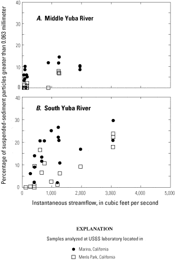
By Jennifer A. Curtis1, Lorraine E. Flint1, Charles N. Alpers1, Scott A. Wright2 and Noah P. Snyder3
U.S. Geological Survey Scientific Investigations Report  2005–5246 , published 2006.
Figure 10
Relation between percent sand (the proportion of suspended-sediment larger than 0.063 millimeter) and instantaneous streamflow for two gaging stations in the upper Yuba River watershed, California. A, Middle Yuba River (11410000). B, South Yuba River (11417500).
[USGS, U.S. Geological Survey]
Figure 10 - Relation between percent sand (the proportion of suspended-sediment larger than 0.063 millimeter) and instantaneous streamflow for two gaging stations in the upper Yuba River watershed, California. A, Middle Yuba River (11410000). B, South Yuba River (11417500).