Use of Sediment Rating Curves and Optical Backscatter Data to Characterize Sediment Transport in the Upper Yuba River Watershed, California, 2001–03
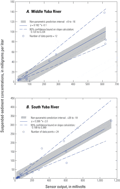
By Jennifer A. Curtis1, Lorraine E. Flint1, Charles N. Alpers1, Scott A. Wright2 and Noah P. Snyder3
U.S. Geological Survey Scientific Investigations Report  2005–5246 , published 2006.
Figure 17
Relation of suspended-sediment concentration and optical backscatter sensor (OBS) output for two gaging stations in the upper Yuba River watershed, California. A, Middle Yuba River (11410000); B, South Yuba River (11417500).
Figure 17 - Relation of suspended-sediment concentration and optical backscatter sensor (OBS) output for two gaging stations in the upper Yuba River watershed, California. A, Middle Yuba River (11410000); B, South Yuba River (11417500).