Use of Sediment Rating Curves and Optical Backscatter Data to Characterize Sediment Transport in the Upper Yuba River Watershed, California, 2001–03
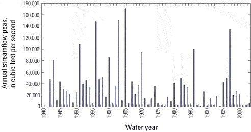
By Jennifer A. Curtis1, Lorraine E. Flint1, Charles N. Alpers1, Scott A. Wright2 and Noah P. Snyder3
U.S. Geological Survey Scientific Investigations Report  2005–5246 , published 2006.
Figure 2
Annual peak streamflows measured from 1942 to 2003 for the gaging station on the Yuba River below Englebright Dam (YRE, 11418000) in the upper Yuba River watershed, California.
See table 1 for station name and location. Data source: http://nwis.waterdata.usgs.gov/, accessed November 8, 2004.
Figure 2 - Annual peak streamflows measured from 1942 to 2003 for the gaging station on the Yuba River below Englebright Dam (YRE, 11418000) in the upper Yuba River watershed, California.