Use of Sediment Rating Curves and Optical Backscatter Data to Characterize Sediment Transport in the Upper Yuba River Watershed, California, 2001–03
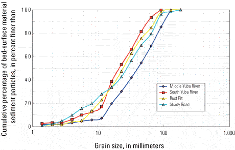
By Jennifer A. Curtis1, Lorraine E. Flint1, Charles N. Alpers1, Scott A. Wright2 and Noah P. Snyder3
U.S. Geological Survey Scientific Investigations Report  2005–5246 , published 2006.
Figure 7
Cumulative percentage of the grain-size distribution of bed-surface material for two bed-load sampling sites located in Shady Creek and gaging stations on the Middle Yuba River (11410000) and South Yuba River (11417500) in the upper Yuba River watershed, California.
Figure 7 - Cumulative percentage of the grain-size distribution of bed-surface material for two bed-load sampling sites located in Shady Creek and gaging stations on the Middle Yuba River (11410000) and South Yuba River (11417500) in the upper Yuba River watershed, California.