
Figure 2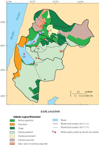
Location of sampling sites, watersheds, and land use in Abbotts Lagoon watershed.
Environmental Setting
Study Area
Abbotts Lagoon and its watershed is a unique hydrologic system in Point Reyes National Seashore, combining rare wilderness dune habitat with active ranching operations (Brannon Ketcham, National Park Service, oral commun., 2005). The lagoon is easily accessible by way of a walking trail maintained by the NPS from the parking lot (fig. 1). It is a favorite hike for many visitors to Point Reyes National Seashore, especially among bird-watching enthusiasts (Salcedo-Chourre, 2003). Four historic ranches are located within the 5.3-mi2 watershed area: two are operated as dairies and two as beef cattle ranches. The lagoon is actually three separate, yet usually surficially connected, waterbodies. These will be referred to in this report as the upper lagoon, middle lagoon, and lower lagoon (fig. 1). The small, shallow upper lagoon is separated from the much larger and deeper middle lagoon by an earthen berm. The middle lagoon is separated from the largest and deepest lower lagoon just below the footbridge on the NPS trail by an outcropping of the Monterey Formation. The lowest lagoon is usually separated from the ocean by the sandy beach. However, the beach berm occasionally breaches for short periods, allowing the direct exchange of seawater with the lagoon(s). Data collection sites and drainage basin boundaries for each water-quality site are shown on figure 1.
Land Use
Land use information for the Abbotts Lagoon basin was provided by NPS staff (Brannon Ketcham, National Park Service, written commun., 2001). The general land use categories provided by NPS staff are native vegetation, sand dunes, silage, grazing (permanent, seasonal, and general), and dairy- and (or) ranching-impacted. The grazing categories distinguish between dairy and beef cattle grazing and the level of grazing impact. The general grazing category is used for beef cattle grazing where the animals are able to graze year round, but they are spread out over a relatively large area. The seasonal grazing category is for dairy cattle, where the animals are able to graze on a relatively small area and for a limited number of months each year. The permanent grazing category is for dairy cattle where the animals are able to graze on a relatively small area for the entire year. The dairy- and (or) ranching-impacted category is where there are permanent feeding and (or) milking structures associated with the dairy and (or) ranching operations. The land use categories and information was provided by NPS staff and digitized into an ArcInfo Geographical Informational System coverage (fig. 2). Overlaying the basin boundaries made it possible to summarize the percentage of each land use in each sampled water-quality basin (table 1).
Table 1
(View this table on a separate page.)
Sampling sites, drainage areas, and land use in Abbotts Lagoon watershed.
[ID, identification; NA, not applicable; mi2, square mile]
[ID, identification; NA, not applicable; mi2, square mile]
| Land use, percentage of basin area | ||||||||||||
|---|---|---|---|---|---|---|---|---|---|---|---|---|
| Site no. (see fig. 1) | Site name | Site ID | Basin area (mi2) | Native vegetation | Sand dunes | Water | Silage | Grazing (general) | Grazing (permanent) | Grazing (seasonal) | Dairy/ranching (impacted) | |
| L1 | Abbotts Lagoon, upper small lagoon | 380736122562401 | 1.92 | 22.1 | 0.0 | 0.7 | 29.1 | 5.0 | 7.3 | 29.7 | 6.1 | |
| L2 | Abbotts Lagoon, middle lagoon | 380717122564101 | 2.47 | 22.4 | 0.4 | 3.2 | 21.4 | 24.2 | 4.7 | 19.3 | 4.3 | |
| L3 | Abbotts Lagoon, lower lagoon | 380652122570501 | 5.29 | 13.5 | 5.9 | 6.2 | 14.1 | 44.5 | 2.7 | 10.8 | 2.4 | |
| T1 | Unnamed tributary 1 to Upper Abbotts Lagoon | 380738122560701 | 0.98 | 18.2 | 0.0 | 0.0 | 17.9 | 8.7 | 8.2 | 46.9 | 0.0 | |
| T2 | Unnamed tributary 2 to Upper Abbotts Lagoon | 380753122561501 | 0.18 | 49.0 | 0.0 | 0.0 | 14.0 | 0.0 | 11.3 | 0.0 | 25.6 | |
| T3 | Unnamed tributary 3 to Upper Abbotts Lagoon | 380752122562501 | 0.07 | 2.0 | 0.0 | 0.0 | 26.7 | 0.0 | 0.0 | 34.0 | 37.3 | |
| T4 | Unnamed tributary 4 to Middle Abbotts Lagoon | 380722122561601 | 0.12 | 4.2 | 0.0 | 0.0 | 31.2 | 64.6 | 0.0 | 0.0 | 0.0 | |
| T5 | Unnamed tributary 5 to Middle Abbotts Lagoon | 380708122563501 | 0.05 | 0.7 | 0.0 | 0.0 | 0.0 | 99.3 | 0.0 | 0.0 | 0.0 | |
| T6 | Unnamed tributary 6 to Lower Abbotts Lagoon | 380642122563601 | 0.42 | 0.0 | 0.0 | 0.0 | 0.0 | 97.6 | 0.0 | 0.0 | 2.4 | |
| T7 | Unnamed tributary 7 to Lower Abbotts Lagoon | 380633122564001 | 0.62 | 0.0 | 0.0 | 0.0 | 0.2 | 99.8 | 0.0 | 0.0 | 0.0 | |
| T1–T7 | Total drainage area for tributaries T1—T7 | NA | 2.44 | 11.2 | 0.0 | 0.0 | 10.6 | 50.9 | 4.1 | 19.8 | 3.4 | |
| L3 minus water and tributaries T1–T7 | Abbotts basin land area not in tributary basins | NA | 2.52 | 17.5 | 12.4 | 0.0 | 19.3 | 44.1 | 1.7 | 3.5 | 1.8 | |
Land use in the basin of the upper lagoon is 42.0 percent grazing, 29.1 percent silage, 22.1 percent native vegetation, and 6.1 percent dairy- and (or) ranching-impacted operations. Because the upper lagoon flows into the middle lagoon, it is part of the middle lagoon basin; in fact, it accounts for about 78 percent of the basin area for the middle lagoon. The drainage directly to the middle lagoon—that is not part of the basin for the upper lagoon—has relatively more grazing, less silage, and no dairy and (or) ranching impacted operations. Likewise, the basin area for the lower lagoon includes the basin areas of the upper and middle lagoons. Relative to the upper and middle lagoons, the drainage directly to the lower lagoon has more grazing and sand dunes, and less native vegetation, silage, and dairy and (or) ranching impacted operations.
The drainage basin for the perennial stream at site T1 is the largest (0.98 mi2) of the sampled tributaries (table 1). It is dominated by grazing (63.8 percent), with about 18 percent each in silage and native vegetation. Tributaries T2 and T3 drain the I Ranch dairy area and 25.6 and 37.3 percent of their drainage basins, respectively, are dairy-impacted operations. The rest of the drainage basin for T2 is primarily native vegetation (49.0 percent), and about 14 percent silage and 11 percent grazing. The rest of the drainage basin for T3 is primarily grazing (34.0 percent) and silage (26.7 percent). Tributaries T1, T2, and T3 drain into the small upper lagoon. Tributaries T4 and T5 were sampled along the NPS footpath leading from the Abbotts Lagoon parking area to the footbridge between the middle and lower lagoons. They drain directly to the middle lagoon and have relatively small drainage basins that are dominated by grazing—64.6 and 99.3 percent, respectively. The T4 drainage basin has 31.2 percent silage. Tributaries T6 and T7 drain directly to the lower lagoon, and their drainage basins are dominated by grazing, with 97.6 and 99.8 percent, respectively. The T6 drainage basin also includes a ranching-impacted operation (H Ranch) at the upper end of the watershed.
The area drained by sampled tributaries (T1–T7) is 2.44 mi2, 49.2 percent of the total drainage-basin land area of 4.96 mi2 (table 1). The land not in the sampled tributary basins has relatively more native vegetation, sand dunes, and silage, and relatively less grazing and dairy- and (or) ranching-impacted land use than the land in the sampled tributary basins (table 1). The most intensive animal land uses (permanent and seasonal grazing, and dairy- and [or] ranching-impacted) account for 16.9 percent of the Abbotts basin land area. These land uses represent 27.3 percent of the land drained by the sampled tributaries, but only 7.0 percent of the other land in the Abbotts basin. The only intermittent stream of significance enters the lower lagoon from the south (fig. 1) and was virtually inaccessible during storm events.

