
Figure 1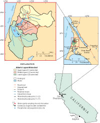
Location of sampling sites, sites for precipitation and evaporation data, sites for continuous stage recorders, and watersheds in Abbotts Lagoon watershed.
Introduction
Abbotts Lagoon is part of Point Reyes National Seashore, located about 40 mi northwest of San Francisco and about 20 mi south of Bodega Bay (fig. 1). The land was originally part of the Rancho Punta de los Reyes Sobrante land grant and was used extensively for grazing dairy and beef cattle. The National Park Service (NPS) acquired the land following park establishment in 1962. The area is now managed by the NPS, to preserve the natural and cultural resources of the area. As part of the pastoral zone, several historical dairy and beef cattle ranches from the mid-1800s are still in operation. Four ranches are partially or completely in the Abbotts Lagoon watershed. The I Ranch dairy and the H Ranch beef cattle ranch are completely in the watershed. The L Ranch dairy and the G Ranch beef cattle ranch are only partially in the watershed.
The most extensive evaluation of water-quality conditions in Abbotts Lagoon was conducted in the late-1980s (Anima, 1991). The study concluded that the upper portion of Abbotts Lagoon was especially susceptible to eutrophic conditions, as evidenced by relatively high nutrient and chlorophyll levels (Steve Hagar, U.S. Geological Survey, written commun., 1991). However, the lack of either streamflow information or sufficient monitoring of inflows made it impossible to conclude anything about the significance of nutrient sources. Using Pb210 radioactive isotope analysis of sediments in middle and lower Abbotts Lagoon, Anima (1991) estimated a sedimentation rate between 8 and 19 cm for every 100 years. This rate was slower than neighboring Drakes Estero. Anima (1991) attributed this slower rate to less sediment input from cliff erosion in Abbotts Lagoon from the Monterey Formation that is more resistant to erosion than the Purisima Formation at Drakes Estero. Anima (1991) concluded that the main sources of sediment supply to Abbotts Lagoon is from Aeolian dune encroachment, open-coast processes (berm overwash and wave erosion), and stream input.
The objective of this report is to provide a comprehensive summary of the work done in this study. The primary objectives of this study were to compare the water quality of storm runoff from subbasins with contrasting land uses and to evaluate seasonal variations in water quality in the most significant tributary stream and the lagoon. This study was funded by the U.S. Geological Survey (USGS) under a competitive grant from the NPS–USGS Water-Quality Monitoring and Assessment Partnership. The other half of this study was an assessment of the fishery resources in Abbotts Lagoon, carried out by Michael Saiki of the USGS, Biological Resources Discipline (Saiki and Martin, 2001).

