U.S. Geological Survey Scientific Investigations Report 20055276
Published 2005
Online only
Version 1.0
By Gregory J. Walsh and Aaron M. Satkoski
This study was designed to determine the levels of naturally occurring radioactivity in bedrock from surface measurements at outcrops during the course of 1:24,000-scale geologic mapping and to determine which rock types were potential sources of radionuclides.
Elevated levels of total alpha particle radiation (gross alpha) occur in a public water system in Montpelier, Vermont. Measured gross alpha levels in the Murray Hill water system (Vermont Dept. of Environmental Conservation, unpub. data, 2005) have exceeded the maximum contaminant level of 15 picocuries per liter (pCi/l) set by the Environmental Protection Agency (EPA) (EPA, 2000). The Murray Hill system began treatment for radium in 1999. Although this treatment was successful, annual monitoring for gross alpha, radium, and uranium continues as required (Jon Kim, written communication, 2005). The water system utilizes a drilled bedrock well located in the Silurian-Devonian Waits River Formation. Kim (2002) summarized radioactivity data for Vermont, and aside from a statewide assessment of radon in public water systems (Manning and Ladue, 1986) and a single flight line from the National Uranium Resource Evaluation (NURE) (Texas Instruments, 1976) (fig. 1), no data are available to identify the potential sources of naturally occurring radioactivity in the local bedrock.
Airborne gamma-ray surveys are typically used for large areas (Duval, 2001, 2002), and ground-based surveys are more commonly used for local site assessments. For example, ground-based surveys have been used for fault mapping (Iwata and others, 2001), soil mapping (Roberts and others, 2003), environmental assessments (Stromswold and Arthur, 1996), and mineral exploration (Jubeli and others, 1998). Duval (1980) summarized the methods and applications of gamma- ray spectrometry.
In this study, we present the results from a ground-based gamma-ray survey of bedrock outcrops in the 7.5-minute Barre West quadrangle, Vermont. Other related and ongoing studies in the area are addressing potential mineral sources of radionuclides (Satkoski and Walsh, 2004; Satkoski and others, 2005), radionuclides in ground water (Kim and others, 2005), and bedrock geology.
|
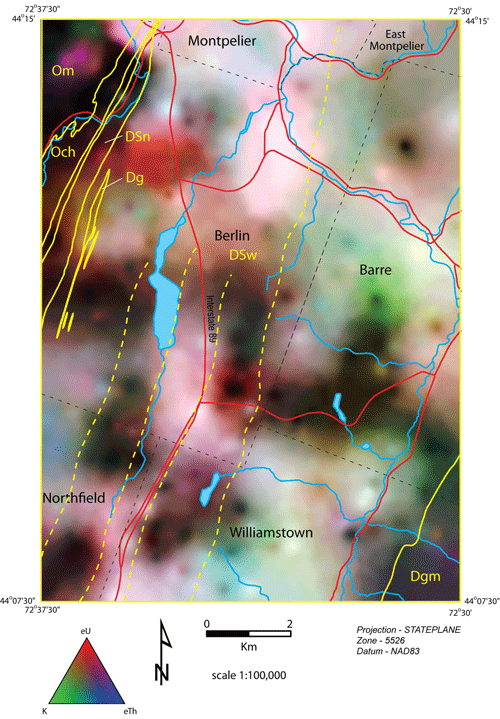
Composite eU-eTh-K concentration map (40-meter grid) showing relative abundances of U, Th, and K. Red areas indicate relatively higher U, blue areas indicate relatively higher Th, green areas indicate relatively higher K, white areas indicate relatively high concentrations of all three elements, and dark areas indicate relatively low concentrations of the three elements. Click on thumbnail to see full-sized version of figure 9A. |
The text part of this report is presented in Adobe PDF format. To download, right-click (PC) or control-click (Macintosh) the link below.
SIR 20055276 text [4.6 MB] | SIR 2005-5276 text, Section-508 Compliant [4 MB]To view files in PDF format, download free copy of Adobe Reader.
![]()
All of the files except for the text pamphlet PDF file (above) are included in sir055276.zip [3.8 MB].
File directory layout:
|--README.TXT---ASCII text description
|--METADATA.HTM---Metadata file in HTML format
|--METADATA_FAQ.HTM---Metadata file of Frequently Asked Questions in HTML format
|
|---EXPORT---Folder - Contains Arc/Info GIS export-interchange file
|
|---SHAPE---Folder - Contains ArcView GIS point and tic shapefiles
|
|---SDTS---Folder - Contains database in SDTS format (geographic coordinates
|          in decimal degrees)
|
|---BASE---Folder - Contains basemap image file and worldfile in DRG format
For questions or comments concerning the scientific content of this report, contact Gregory J. Walsh.

![]() U.S. Department of the Interior |
U.S. Geological Survey
U.S. Department of the Interior |
U.S. Geological Survey
URL: https://pubsdata.usgs.gov/pubs/sir/2005/5276/index.html
Page Contact Information: Publication Services Group
Page Last Modified: 18:51:25 Thu 01 Dec 2016
