Introduction
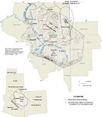
The C aquifer underlies much of northeastern Arizona, and parts of northwestern New Mexico (fig. 1), and is an important source of water for many users. It is named for the primary water-bearing rock unit of the aquifer, the Coconino Sandstone. The aquifer is the most productive aquifer in the Little Colorado River Basin. Industrial users, individual homeowners, agriculture, and the municipalities of Flagstaff, Holbrook, Leupp, Show Low, St. Johns, Joseph City, Snowflake, Taylor, and Winslow, Arizona, depend upon water drawn from wells completed in the aquifer. Because the aquifer lies beneath the Navajo and Hopi Indian Reservations, it represents an important present and future source of water to support these native peoples and their economies.
Water from the C aquifer is proposed as a replacement supply for mine-related withdrawals from the N aquifer—the current source of water for a coal slurry pipeline used to transport coal mined from Black Mesa to the Mojave Generating Station, an electrical power plant in Laughlin, Nevada. Water from the N aquifer generally is of good quality. Replacement of the supply by poorer quality from the C aquifer would reduce industrial use of the N aquifer water, a current supply for tribal communities. The proposed area of withdrawals for replacement water from the C aquifer is near Leupp, Arizona. A pipline would be required to transport the water to the coal mine on Black Mesa. Along with withdrawals for the mine, withdrawals also are proposed for Hopi and Navajo water supply.
The base flow of parts of some streams, including Chevelon and Clear Creeks, and of the Little Colorado River is sustained by discharge from the C aquifer, and in some cases, these streams support threatened and endangered fish species. The C aquifer discharges into the Verde River and Salt River Basins to the south, and to underlying formations and ultimately to the lower Little Colorado River to the northwest (fig. 1). Blue Spring, about 13 river miles (mi) upstream from the mouth of the Little Colorado River, is the largest of many springs that discharge in the lower reach of the river.
Purpose and Scope
In 2004, the U.S. Geological Survey (USGS), in cooperation with the Bureau of Reclamation, was requested to participate on a Federal team to evaluate potential effects of future ground-water withdrawal scenarios from the C aquifer on base flow in the Chevelon and Clear Creek drainages, and ground-water discharge to the Little Colorado River in the area of Blue Spring. USGS participation on the Federal team involved assisting with test drilling and associated aquifer testing in the Leupp, Arizona, area (Hoffmann and others, in press) and with development of a numerical ground-water model of the C aquifer, discussed in this report.
The purpose of this report is to describe results of an analysis of pumping effects on base flow using a numerical ground-water model. The model was used to evaluate the effect of pumping on base flows of Chevelon and Clear Creeks and on ground-water discharge to the Little Colorado River near Blue Spring area for specified withdrawals and periods. Evaluations were carried out using two scenarios of withdrawals provided by a technical advisory group (Craig Sommers, Economist, ERO Resources Corporation, Denver, Colorado, written commun., 2005). Results are limited to calculated stream depletions and drawdown values.
Previous Investigations
Parts of the C aquifer have been investigated to evaluate water availability for local water supply. Peter Mock Groundwater Consulting, Inc. (2003) constructed a ground-water flow model of a 2,400-mi2 rectangular part of the C aquifer encompassing Clear and Chevelon Creeks south and east of Leupp, Arizona. The ground-water flow model was used to estimate the changes in ground-water levels near the proposed well fields, at other existing and proposed water demand centers, and in base flow of Clear and Chevelon Creeks. Boundary conditions for this local-scale model were derived using a regional analytical model (Southwest Ground-water Consultants, Inc., 2003). The analytical model used the Theis nonequilibrium equation with the Jacob water-table correction, with a transmissivity of 25,000 (gal/d)/ft (3,300 ft2/d) and a specific yield of 0.07.
Two recent studies have attempted to characterize the aquifer on a regional scale or over its full extent. In the area of Flagstaff, Arizona, the C aquifer was investigated by Bills and others (2000). This study included extensive structural mapping, geophysical surveying and mapping, determination of hydraulic properties, and chemical and isotopic analysis of ground water. A ground-water budget and a generalized characterization of the geohydrology of the entire C aquifer were developed by Hart and others (2002). Several other reports provide information on water resources in the study area including the C aquifer. Cooley and others (1969) describe the hydrogeology of the Navajo and Hopi Reservations and McGavock and others (1986), Mann and Nemecek (1983), and Mann (1976) describe water resources in southern parts of Coconino, Navajo, and Apache Counties, respectively.
Acknowledgments
Bill Greenslade and John Ward provided data sets that were helpful in providing information used to constrain aquifer thickness. Craig Sommers, Jason John, and Kevin Black were instrumental in providing information related to pumping scenarios. Don Bills provided guidance on the geology and hydrology of the study area, Alice Konieczki assembled much of the data needed from USGS sources, and Marilyn Flynn carried out Geographic Information System (GIS) analyses that were essential to constructing the model and presenting results. Claire Tiedeman provided guidance in strategies for calibration and Monte Carlo analyses. The modeling subcommittee members of the Federal team provided constructive input on model development.


