|
|
|
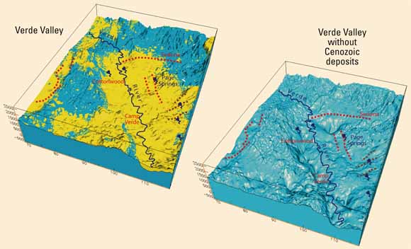
Analysis of aeromagnetic and gravity data provides new insights into the geometry of geologic structures of the upper and middle Verde River watershed, Yavapai County, Arizona. Magnetic anomalies reveal hidden volcanic rocks lying at shallow depths beneath the ground surface in Williamson, Little Chino, Big Chino, and Verde Valleys in the upper Verde River watershed. Concentrations of shallowly buried volcanic plugs or centers are located down-gradient of springs (Del Rio) and perennial flow (Williamson Valley), suggesting that these volcanic centers or plugs may retard ground-water flow. Magnetic data also map paleochannels that were filled with basalt (6 to 4 Ma) as Big Chino Valley formed and subsided during late Tertiary. The magnetic data reveal a predominantly northeast- to north-striking structural grain within Proterozoic basement rocks, in contrast to the generally northwest strike of late Tertiary faults in this region. The magnetic grain may serve as a proxy for fracturing and faulting, an important source of permeability in these generally impermeable rocks. Magnetic and gravity data also delineate exposed and concealed faults within the study area. The Big Chino Fault and Verde Fault Zone have the largest amounts of vertical throw of the faults in the study area on the basis of gravity, magnetic, and limited well data. These faults bound deep (1-2 km) basins in Big Chino and Verde Valleys. The geophysical data also reveal concealed faults in Williamson Valley that bound a previously undiscovered basin with approximately 1 km of Cenozoic fill inferred from inversion of gravity data. Little Chino and Lonesome Valleys, including the upper reach of the Agua Fria Basin, are characterized by basin fill that has an irregular distribution, with local, north- to northwest-striking pockets of thicker sediment, but nowhere exceeds 1 km of thickness. A 15- to 20-km-long northwest-striking magnetic lineament that passes through Page Springs in Verde Valley can be used to project a mapped fault 5-10 km northwest and southeast of its mapped trace. The colocation of the lineament, mapped fault, and Page Springs suggests structural influence on the location of this large spring. |
Download the text of this report as a 30-page PDF document (sir5278_text.pdf; 14.5 MB)
Download plate 1 of this report as a ~33" x 25" PDF document (sir5278_plate.pdf; 16 MB)
For questions about the content of this report, contact Vicki Langenheim.
Learn more about Understanding Geohydrology; Investigating Geohydrologic Systems from Geologic Framework and History
|
Help |
PDF help |
Publications main page |
U.S. Geological Survey
Information Services, National Mapping Division
Box 25046
Denver Federal Center
Denver, CO 80225-0046
Telephone: (888) ASK-USGS
ISBN: 1-411-30914-6
Current pricing information is available from http://mapping.usgs.gov/esic/prices/.