Scientific Investigations Report 2005–5283
In cooperation with the National Park Service
Simulation of Ground-Water Flow
Figure 1. Location of study area, St. Croix River Basin, Minneso...
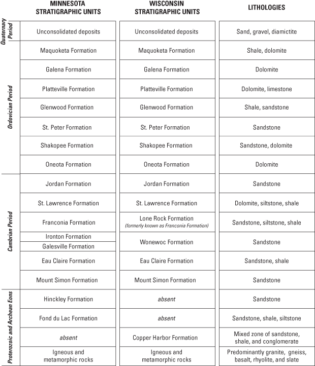
Figure 2. Stratigraphic units and corresponding lithologies in t...
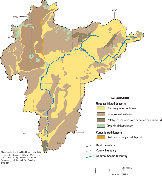
Figure 3. Distribution of unconsolidated and consolidated deposi...
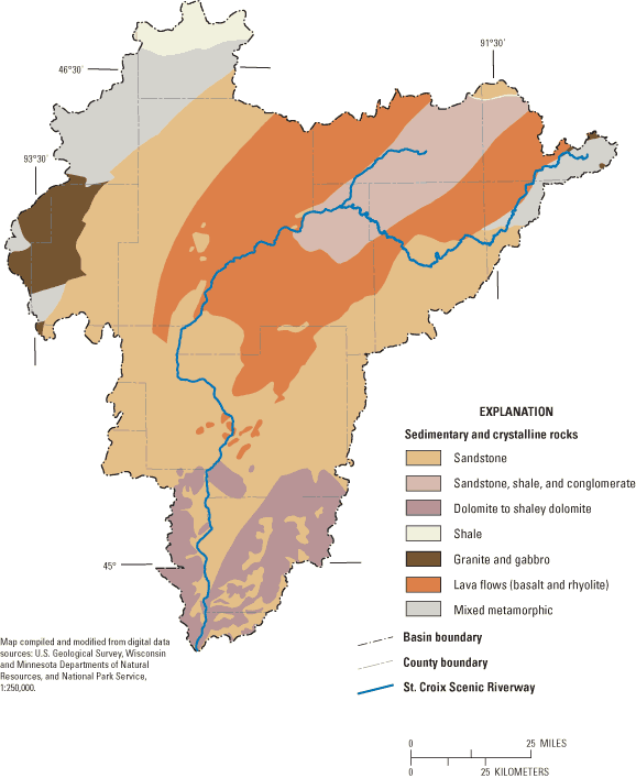
Figure 4. Distribution of sedimentary and crystalline rocks, St....
Figure 5a. Generalized thickness of unconsolidated deposits base...
Figure 5b. Generalized thickness of sedimentary bedrock based on...
Figure 6. Conceptualized cross sections in the northern, central...
Figure 7a. Location of wells where data were provided for zonati...
Figure 7b. Generalized zones of relative magnitude of average hy...
Figure 8. Recharge zones, St. Croix River Basin, Minnesota and W...
Figure 9. Near-field and far-field linesinks of the surface-wate...
Figure 10. Locations of production wells and other high-capacity...
Figure 11. Location of water-level observations (average recorde...
Figure 12a. Observed water-table altitude (average recorded betw...
Figure 12b. Simulated water-table altitude, St. Croix River Basi...
Figure 13. Locations of streamflow-gaging stations, St. Croix Ri...
Figure 14. Transmissivity zones from model calibration and effec...
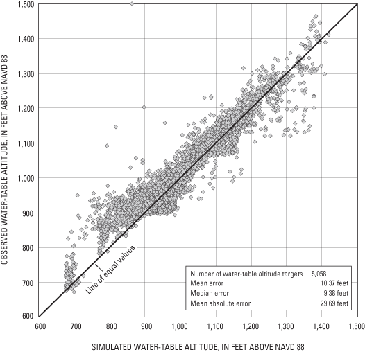
Figure 15. Model-simulated and observed water-table altitudes, a...
Figure 16. Distribution of water-level residuals for the screeni...
Figure 17. Model-simulated and estimated base flows, St. Croix R...
Figure 18. Locations of key stream reaches that were identified ...
Figure 19. Contributing areas to key stream reaches, St. Croix R...
Figure 20. Model-simulated areas of relatively rapid (less than ...
Table 1. Lithologies and hydraulic conductivity values assigned ...
Table 2. Optimized parameter estimates resulting from applicatio...
Table 3. Estimated and simulated base flow at streamflow-gaging ...
|
Multiply
|
By
|
To Obtain
|
|
Length
|
||
| foot (ft) | 0.3048 | meter (m) |
| mile (mi) | 1.609 | kilometer (km) |
|
Area
|
||
| square mile (mi2) | 259 | hectare (ha) |
| square mile (mi2) | 2.59 | square kilometer (km2) |
|
Flow rate
|
||
| million gallons per day (Mgal/d) | 3785 | cubic meter per day (m3/d) |
| foot per year (ft/yr) | 0.3048 | meter per year (m/yr) |
| cubic foot per second (ft3/s) | 0.02832 | cubic meter per second (m3/s) |
| inch per year (in/yr) | 25.4 | millimeter per year (mm/yr) |
|
Hydraulic conductivity
|
||
| foot per day (ft/d) | 0.3048 | meter per day (m/d) |
|
Transmissivity*
|
||
| foot squared per day (ft2/d) | 0.0929 | meter squared per day (m2/d) |
|
Vertical coordinate information is referenced to the North American Vertical Datum of 1988 (NAVD 88). Horizontal coordinate information is referenced to the North American Datum of 1983 (NAD 83). Altitude, as used in this report, refers to distance above the vertical datum. *Transmissivity: The standard unit for transmissivity is cubic foot per day per square foot times foot of aquifer thickness [(ft3/d)/ft2]ft. In this report, the mathematically reduced form, foot squared per day (ft2/d), is used for convenience. |
||
A series of databases and an accompanying screening model were constructed by the U.S. Geological Survey, in cooperation with the National Park Service, to better understand the regional ground-water-flow system and its relation to stream drainage in the St. Croix River Basin. The St. Croix River and its tributaries drain about 8,000 square miles in northeastern Minnesota and northwestern Wisconsin. The databases contain information for the entire St. Croix River Basin pertaining to well logs, lithology, thickness of lithologic groups, ground-water levels, streamflow, and well pumpage. Maps and generalized cross sections created from the compiled data show the lithologic groups, extending from the water table to the crystalline bedrock, through which ground water flows. These lithologic groups are: fine-grained unconsolidated deposits; coarse-grained unconsolidated deposits; sandstone bedrock; carbonate bedrock; and other bedrock lithologies including shale, siltstone, conglomerate, and igneous intrusions.
The steady-state screening model treats the ground-water-flow system as a single layer with transmissivity zones that reflect the distribution of lithologic groups, and with recharge zones that correspond to general areas of high or low evapotranspiration. The model includes representation of second- and higher-order streams and municipal and other high-capacity production wells. The analytic-element model code GFLOW was used to simulate the regional ground-water flow, the water-table surface across the St. Croix River Basin, and base-flow contributions from ground water to streams. In addition, the model routes tributary base flow through the stream network to the St. Croix River. The parameter-estimation inverse model UCODE was linked to the GFLOW model to select the combination of parameter values best able to match over 5,000 water-level measurements and base-flow estimates at 22 streamflow-gaging stations. Results from the calibrated screening model show ground-water contributing areas for selected stream reaches within the basin. The delineation of these areas is useful to water-resource managers concerned with protection of fisheries and other resources. The model results also identify the areas of the basin where ground-water travel time from the water table to streams and wells is relatively short (less than 50 years). Ninety percent of the simulated ground-water pathlines require travel times between 3 and 260 years. The median pathline distance traversed and the median pathline velocity were 1.7 mi and 177 ft/y, respectively.
It is important to recognize the limitations of this screening model. Heterogeneities in subsurface properties and in recharge rates are considered only at a very broad scale (miles to tens of miles). No account is taken of vertical variations in properties or pumping rates, and no provision is made to account for stacked ground-water-flow systems that have different flow patterns at different depths. Small-scale (hundreds to thousands of feet) flow systems associated with minor water bodies are neglected, and as a result, the model is not useful for simulating typical site-specific problems. Despite its limitations, the model serves as a framework for understanding the regional pattern of ground-water flow and as a starting point for a generation of more targeted and detailed ground-water models that would be needed to address emerging water-supply and water-quality concerns in the St. Croix River Basin.
The St. Croix River and its tributaries drain parts of eastern Minnesota and western Wisconsin (fig. 1). Water quality of the St. Croix River is a critical concern of the National Park Service (NPS) because of its responsibility to manage and protect the St. Croix National Scenic Riverway (hereafter referred to as "Riverway"). Water quality is also a critical concern for State, county, and local resource managers, particularly in those watersheds bordering the Riverway that are experiencing rapid population growth and development. A number of water-quality studies have been conducted to determine source areas of contamination in the St. Croix River Basin (hereafter referred to as "basin") and to estimate contaminant loading to the St. Croix River and its tributaries (for example, Lenz and others, 2001; Fallon and McNellis, 2000; Grazcyk, 1986). However, none of these studies have attempted to interpret water-quality data in light of how ground water circulates through the basin. Prior to this study, little was known about surface-water/ground-water interactions within the basin, or the ground-water contribution to the St. Croix River and its tributaries. Also poorly understood were the general directions and rates of ground-water flow within the basin, the distribution of recharge, and the sensitivity of the ground-water-flow system to changes on the landscape.
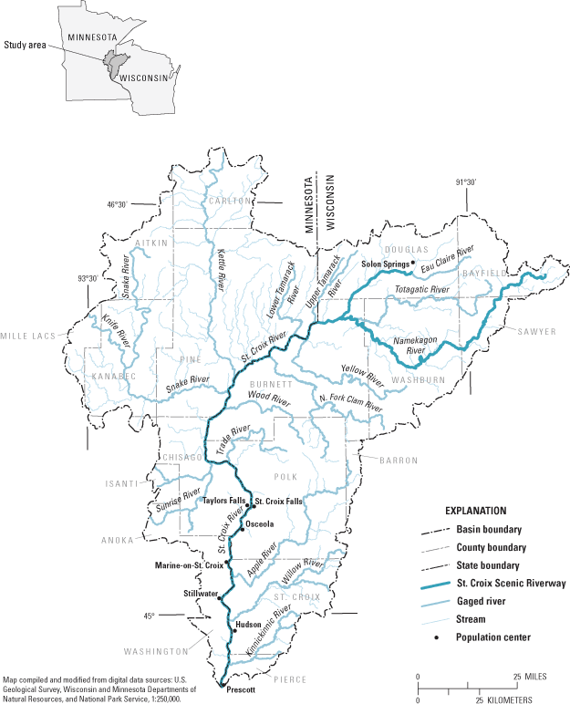
Figure 1. Location of study area, St. Croix River Basin, Minnesota and Wisconsin.
This study was undertaken in 2003 by the U.S. Geological Survey in cooperation with the National Park Service. The primary objectives of the study were to compile hydrogeologic data for the St. Croix River Basin, and use those data to develop a numerical screening model to simulate the ground-water-flow system of the basin. A screening model describes the regional characteristics of the ground-water-flow system without including the hydrogeologic detail or data density that would be necessary for answering site-specific questions. A calibrated screening model can be used with confidence to simulate a regional ground-water-flow system, but with less confidence to simulate local-scale flow. A screening model is a tool that can be used to improve the overall understanding of the hydrology of a basin by testing alternative conceptual models of the ground-water-flow system. Additionally, a screening model can be used to highlight areas where more hydrogeologic or water-quality data are needed. A similar approach could be used in other basins where regional characteristics of the flow system need to be characterized before site-specific issues can be addressed by water-resources managers.
A regional screening model integrates the most important components of the shallow and deep parts of the ground-water-flow system. The ground-water and surface-water systems are believed to be hydraulically well-connected in this region, and, as a result, the ground-water-flow model is constructed to include many aspects of the surface-water network. The simulation of ground-water flow and its interaction with the surface-water network provides the framework necessary to understand and protect the basin's water resources.
By improving the understanding of the hydrology of the St. Croix River Basin, this study provides a basis for interpreting previously collected water-quality data. Another benefit of the study is that the sources and amount of base-flow contribution to the St. Croix River from its subbasins are more systematically known and understood. In addition, the ground-water-flow model provides a regional framework for future site-specific studies.
The hydrogeologic framework that underlies the screening model of the St. Croix River Basin draws from previous geologic and hydrologic studies. The bedrock geology of the basin is described in a number of publications, notably Norvitch and others (1973) and, more recently, Paillet and others (2000), and Runkel (2000, 2003). Other reports present descriptions of the soil and unconsolidated deposits of the area (Schwarz and Alexander, 1995; Soller and Packard, 1998). The general hydrology of the basin is described in a series of Hydrologic Atlases published by the U.S. Geological Survey in the early 1970's (Lindholm, Helgesen, Broussard, and Ericson, 1973, 1974; Lindholm, Helgesen, Broussard, and Farrell, 1974; Young and Hindall, 1973). Additional hydrogeologic detail has been provided by county geology and ground-water resources reports for St. Croix County, Wisconsin, and Washington County, Minnesota (Borman, 1976; Swanson and Meyers, 1990), and by water-table maps for Burnett and Polk Counties in Wisconsin (Muldoon and Dahl, 1998; Muldoon, 2000).
The purpose of this report is to describe the hydrogeology of the St. Croix River Basin and the development and application of a numerical screening model for ground-water flow. The report includes a summary of selected hydrologic data, conceptualization of the hydrogeologic setting of the basin, and details on the construction and calibration of a one-layer steady-state analytic-element model that simulates ground-water flow and its interaction with surface-water features at a coarse, regional scale. On the basis of model simulations, maps are presented that delineate ground-water recharge areas for selected stream reaches and a map that shows areas within the basin that have relatively rapid ground-water flow (residence times less than 50 years).
A primary motivation for this study comes from the responsibility of the NPS to manage and protect the St. Croix National Scenic Riverway. The Riverway was established in 1968 under the National Wild and Scenic Rivers Act. The Riverway includes the Namekagon River and the St. Croix River that together provide 252 mi of recreational area. The Riverway contains diverse habitats supporting a wide variety of plants and wildlife. The St. Croix River drainage basin is 7,760 mi 2 in Minnesota and Wisconsin (Holmberg and others, 1997), an area that includes all or parts of 19 counties. The St. Croix River (fig. 1) originates near Solon Springs, Wisconsin, and flows approximately 154 mi south to its confluence with the Mississippi River at Prescott, Wisconsin. Land cover is variable, changing from predominantly forest cover upstream in the basin to a mixture of forest, agriculture, and urban land-use further downstream. The largest communities in the basin are located in and near the St. Croix River. These communities include Stillwater, Taylors Falls, and Marine-on-St. Croix, Minnesota, and St. Croix Falls, Hudson, and Osceola, Wisconsin. The NPS administers a narrow corridor, in many places less than a quarter-mile wide along the Riverway, from its headwaters to the northern city limits of Stillwater, Minnesota.
Compiling data into accessible databases was an important first step in developing a conceptual model of the ground-water-flow system in the St. Croix River Basin, and in constructing the ground-water-flow screening model. The databases were prepared and managed in three general steps:
The databases provided the hydrogeologic framework for developing a conceptual model of the basin. The conceptual model was translated into a numerical model for simulating the ground-water-flow system. In this study, an analytic-element (AE) ground-water-flow model, using the computer program GFLOW (Haitjema, 1995), was developed to simulate the ground-water-flow system and its interaction with surface-water features. A complete account of AE modeling is beyond the scope of this report, but a brief description is included here.
An infinite aquifer is assumed in AE modeling. The simulated flow system does not require a grid, and therefore, does not involve interpolation between grid cells. To construct an AE model, features important to ground-water flow (for example, wells) and surface-water features (for example, rivers and lakes) are represented spatially as mathematical elements or strings of elements. The amount of detail specified for an element representing any feature depends primarily on the feature's distance from the area of interest. Each mathematical element is represented by an analytic solution to the equation for ground-water flow. The effects of these individual solutions are added together ("superimposed") to arrive at a solution for water levels and ground-water flows. Because the solution is not confined to a grid, water levels and ground-water flows can be computed anywhere in the model domain without nodal averaging. In the GFLOW model used here, the analytic elements are two-dimensional and are used to simulate steady-state conditions; that is, ground-water levels represent average conditions of water-table altitude and streamflow, and no consideration is given to variations in time. AE modeling methods have been extensively documented and implemented in numerical codes (Strack, 1989; Haitjema, 1995), and have been successfully used in a variety of hydrologic settings (for examples of USGS applications, see Hunt and others, 1998, 2000, 2003; and Dunning and others, 2002, 2004; for examples of applications in northwestern Wisconsin and eastern Minnesota see Seaberg, 2000). Of particular interest, AE ground-water-flow models have been used to simulate the main ground-water and surface-water features controlling flow in large, regional ground-water-flow systems on the scale of the St. Croix Basin. In a study by Bakker and others (1999) of the area around the Yucca Mountain nuclear repository site in southern Nevada, some hydrologic boundaries were as far as 300 mi away from the area of interest. In the St. Croix River Basin study, hydrologic boundaries are not so distant. In both studies, however, a primary value of the large-scale screening model is to identify the main features controlling flow. These features can then be used to better define local conditions, test hypotheses, and answer site-specific questions as specific local data are incorporated in the model.
The subsurface within the St. Croix River Basin consists of many hydraulically connected stratigraphic units. Ground-water flow is affected by the sequence, depth, thickness, and hydraulic conductivity of units as well as the distribution of water sources and sinks at the water table and discharge from wells.
The sequence of deposits in the St. Croix Basin reflects a complex geological history. The stratigraphic nomenclature for this sequence of deposits comes from the MGS and the WGNHS, and is presented in figure 2. During periodic glaciations, in particular the most recent Wisconsinan glaciation (10,000–20,000 years ago), sediment carried by glacial ice or by meltwater was deposited over most of the basin. There are some regions in the basin, however, where glacial deposits are thin or absent and bedrock is at or near the surface. Underlying the unconsolidated glacial deposits of Quaternary age are many bedrock units including sedimentary rocks (mostly dolomite and sandstone) of Ordovician age (Maquoketa, Galena, Platteville, Glenwood, St. Peter, Shakopee, and Oneota Formations), Cambrian age (Jordan, St. Lawrence, Franconian, Lone Rock, Wonewoc, Eau Claire, and Mount Simon Formations), and Proterozoic age (Hinkley, Fond du Lac, and Copper Harbor Formations). The sedimentary formations are underlain by Proterozoic and Archean igneous and metamorphic rocks. Because the basin is located in what has been a tectonically active region, periods of faulting have shifted bedrock units both upwards and downwards. Subsequent periods of glaciation and erosion, including the Wisconsinan glaciation, have eroded the subsurface to different depths.
Appreciable ground-water flow occurs through both unconsolidated and bedrock lithologies. Shallow flow within these lithologies is not restricted to any one stratigraphic interval but can pass through Quaternary, Paleozoic, and Precambrian units. Most private high-capacity wells and other production wells withdraw water from glacial deposits, dolomite, and/or sandstone units. In the northwest, central, and northeast parts of the basin, igneous and metamorphic rock generally are present at shallow depths (less than 200 ft); elsewhere, these rocks are encountered at greater depths. Generally, these crystalline rocks are not highly fractured at depth and, therefore, do not easily transmit water. As a result, these rocks are considered to constitute the base of the regional ground-water-flow system.
To represent subsurface complexity in a screening model, it is more useful to characterize the ground-water-flow system in terms of broad lithologic groups than by individual stratigraphic formations or hydrologic units such as aquifers and confining units. The lithologic groups are broadly distinguished by their capacity to transmit ground water. A set of 17,125 logs was compiled and evaluated to group their reported stratigraphy into unconsolidated and consolidated lithologic groups. These logs are tabulated in appendix A.
The unconsolidated deposits of the St. Croix River Basin are generally Quaternary Period or younger and are predominantly glacial in origin (Soller 1992). Most of the coarse-grained unconsolidated deposits have been sorted and deposited as outwash from glacial meltwater, whereas some deposits are from alluvial sources. The outwash deposits usually consist of a mixture of sand and/or gravel with little or no fines (clay or silt). Sediment described as predominantly sand, or sand and silt, is also classified as coarse-grained for the purposes of the screening model. The fine-grained unconsolidated deposits consist mostly of diamictite (often described as till). These deposits were in contact with glacial ice; they are a mixture of poorly sorted sediments with particle size ranging from clay to large boulders but dominated by fine-grained sediment. A generalized distribution of the different types of deposits throughout the basin based on the work of Soller and Packard (1998) is shown in figure 3.
| Lithologic Group | Lithology | Hydraulic conductivity, in feet per day1 |
|---|---|---|
| Coarse-grained unconsolidated | Glacial outwash, or alluvial sand and gravel | 20 |
| Fine-grained unconsolidated | Glacial material dominated by diamictite | 1 |
| Sandstone bedrock | Sandstone | 5 |
| Carbonate bedrock | Mostly dolomite, some limestone | 20 |
| Other bedrock | Shale, siltstone, conglomerate, & igneous intrusions | .1 |
1The assigned values represent the central tendency over a wide range that can span several orders of magnitude.
Detailed geologic logs compiled in appendix B document the distribution of glacial and alluvial deposits with depth. These logs were used as a basis for dividing the unconsolidated deposits across the basin into two lithologic groups (table 1): coarse-grained deposits (glacial outwash or alluvial sand and gravel) and fine-grained deposits (glacial sediments dominated by diamictite).
The bedrock units include a variety of sedimentary, igneous, and metamorphic rocks that commonly subcrop beneath glacial deposits in the St. Croix River Basin. The distribution of sedimentary and crystalline bedrock, based on the work of Cannon and others (1997), is shown in figure 4. Sedimentary bedrock (sandstones, carbonates, and shales) was deposited during the Ordovician, Cambrian, and Precambrian Periods and later subjected to erosion. Most of the carbonate bedrock is dolomite with some limestone, deposited as a sequence hundreds of feet thick in the southern part of the basin during the Ordovician Period. The dolomite and limestone commonly contains partings and fractures. The Cambrian Period is represented primarily by thick sandstone units with interlayered dolomite, fine-grained siltstones, and shales. The Cambrian rocks are widespread in the southern part of the basin but thin northwards into the central basin. No Ordovician or Cambrian sedimentary rocks are present in the northern part of the basin because of tectonism that resulted in volcanic intrusions and uplift, and erosion of these strata. Underlying the Cambrian and Ordovician bedrock in the southern part of the basin and near land surface in the northern part is Proterozoic bedrock that can be divided into various rock types. Proterozoic sandstone is common in the northern and extreme southern parts of the basin. Located in the northeastern part of the basin is a Proterozoic sequence composed of sandstone, shale, and conglomerate that formed as a result of boulders falling from cliffs that were then buried in other sedimentary marine deposits during storms (Dott and Attig, 2004). Proterozoic and Archean lava flows produced basalt and rhyolite along a rift zone that extended from what is now the central to northeastern parts of the basin. Ancient highlands in the northwestern and northeastern parts of the basin result from other volcanic intrusions, and consist of igneous and metamorphic rocks such as granite, gneiss, basalt, rhyolite, or slate. Cambrian and Ordovician formations and Proterozoic sandstones are absent along these highlands. Underlying the entire basin at widely varying depths is the igneous and metamorphic basement, typically granitic or basaltic in composition.
The lithology database (appendix B) contains the sedimentary and crystalline lithologic descriptions from logs of wells that penetrated bedrock. These descriptions have been used to divide all bedrock into three lithologic groups (table 1): sandstone, carbonate, and other bedrock (combining shales, siltstones, conglomerates, and crystalline intrusions). These groupings serve as a basis for input of hydraulic properties to the flow model. Crystalline basement rocks, typically consisting of low-permeability granite and basalt, are defined for model simulation purposes as the base of the ground-water-flow system.
Records were extracted from the well log database (appendix A) to produce figures displaying generalized thickness of unconsolidated deposits (fig. 5a) and bedrock (fig. 5b). GIS software was used to develop the data and to perform the analysis, and a 5,000-m grid size was chosen to display the generalized thicknesses.
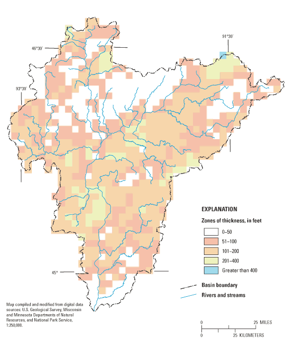
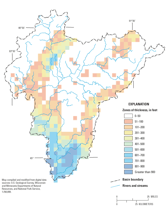
A subset of 12,351 wells selected from appendix A provided information about depth to bedrock and thickness of unconsolidated deposits. In order to fill gaps in basin areas containing little or no well data, an additional 789 data points of depth and thickness were calculated by subtracting the generalized thickness of unconsolidated deposits provided by the Soller and Packard (1998) digital data map for Quaternary deposits from the DEM land-surface altitude. The combined total of 13,140 points produced the generalized unconsolidated deposits thickness grid shown in figure 5a. These data were also used to generate a top of bedrock surface. Two additional subsets of records were selected from appendix A to map the top of crystalline bedrock surface, which is equated with the bottom of the ground-water-flow system in this study. The first subset contains 1,034 wells that explicitly intersect crystalline bedrock; the second subset contains 1,537 wells that penetrate to the deepest known sedimentary stratigraphic units (fig. 2) including sandstone units such as the Cambrian Mt. Simon Formation, and the Proterozoic Hinkley and Fond du Lac Formations. This second subset was used to approximate the minimum depth to crystalline bedrock in areas where direct data were lacking and to generate an altitude surface for the top of crystalline bedrock. The resulting surface for the top of crystalline bedrock was subtracted from a surface representing the top of the first bedrock encountered to yield the thickness of sedimentary bedrock map shown in figure 5b.
The thickness of the unconsolidated deposits ranges from 0 to greater than 400 ft but is typically less than 200 ft (fig. 5a). The lesser thicknesses of the unconsolidated deposits occur in the southern part of the basin and also in areas where unconsolidated deposits are directly underlain by Precambrian crystalline bedrock. The areas identified as "Patchy" in figure 3 indicate areas where sediment, primarily diamictite, is not extensive but surrounds exposed bedrock (Lindholm and others,1974; Young, 1973). Unconsolidated deposit thicknesses are greatest in bedrock valleys and along river channels.
Where present, Ordovician formations can be up to 600 ft thick, but are generally no more than 400 ft thick. Cambrian bedrock in the southern and central parts of the basin vary in thickness from several feet to several hundred feet. The thickness of the Proterozoic sedimentary bedrock is uncertain in most regions of the basin because there are few wells that penetrate these rocks. Most of the lithified bedrock thickness in the northwest part of the basin corresponds to Proterozoic sandstone (fig. 5b). In the southernmost part of the basin on the Minnesota side, the Proterozoic bedrock has been down-faulted several thousands of feet; as a result of this down-faulting, the thickness of the Proterozoic sandstone is uncertain (Austin, 1969).
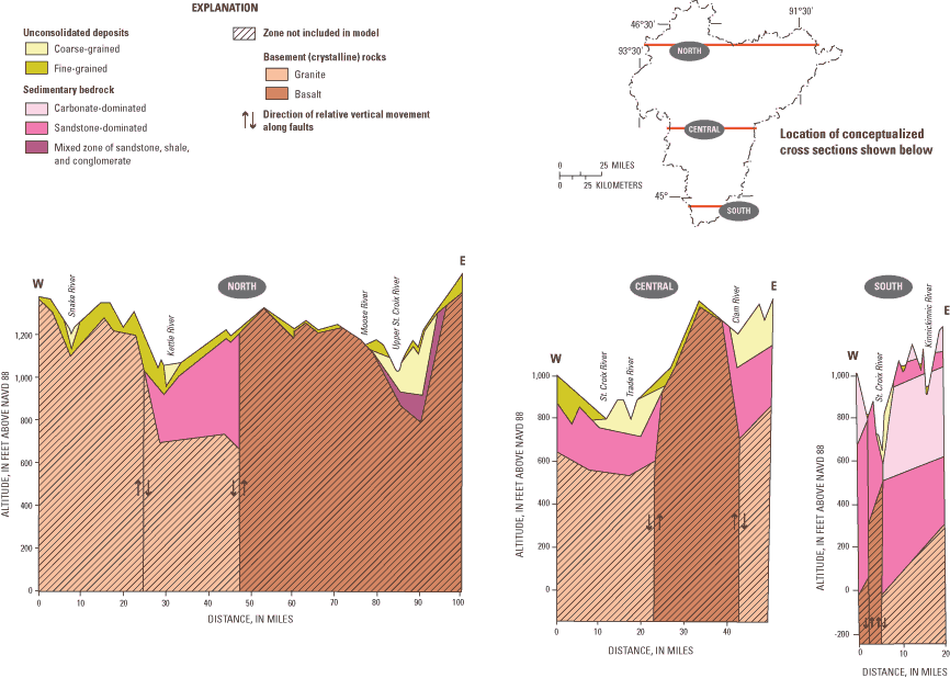
Three conceptualized east-west cross sections (fig. 6) are derived from about 1,000 geologic well logs with lithologic description data provided in appendixes A and B. The thickness and geometry of the different lithologies vary considerably between the northern and central parts of the basin and between the central and southern parts of the basin. Some sandstone and carbonate sequences contain shale and siltstone layers that are on the order of tens of feet thick (fig. 6). Whereas these fine-grained layers are likely to affect the vertical circulation of flow, they have little effect on the overall transmissivity of the ground-water-flow system.
Subsurface material can be classified according to its permeability; that is, its capacity to transmit water. Permeability is measured by the parameter hydraulic conductivity. The character of the ground-water-flow system depends not only on the spatial distribution and thickness of materials with different hydraulic conductivity values, but also on the availability of water to the system across the ground-water basin in the form of recharge and on the location of discharge areas in the form of surface-water features and wells.
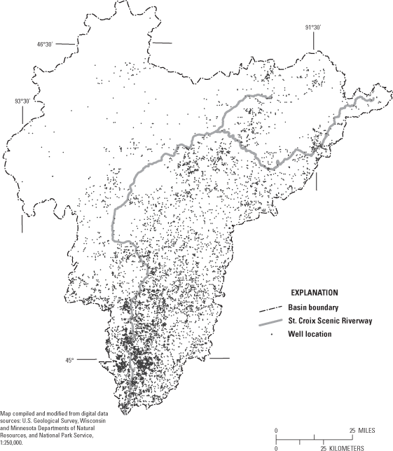
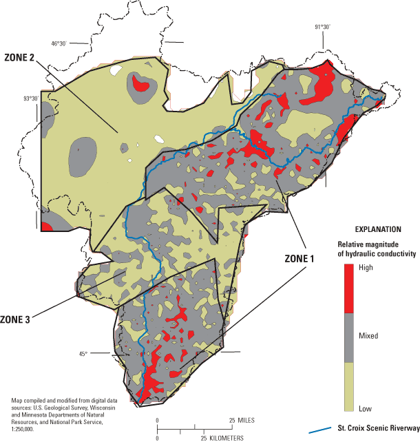
The lithologic descriptions compiled in each of approximately 11,000 wells (fig. 7a) have been assigned to one of five lithologic groups: 1) Coarse-grained unconsolidated (glacial outwash, or alluvial sand and gravel), 2) fine-grained unconsolidated (glacial deposits dominated by diamictite), 3) sandstone bedrock, 4) carbonate bedrock (mostly dolomite, some limestone), and 5) other bedrock (shale, siltstone, conglomerate, or crystalline intrusions). The summed thickness of each group in each log is recorded in appendix C. The thicknesses of glacial outwash or alluvial sand and gravel, sandstone bedrock, and carbonate bedrock are assumed to account for most of the capacity of the lithologic groups to transmit water. Because wells tend to be shallow in areas where deeper units have low hydraulic conductivity (for example, the northwestern part of the basin where glacial sediments overlie volcanic and crystalline rocks) and deep in areas where deeper units have higher hydraulic conductivity (for example, the southern part of the basin where glacial sediments overlie transmissive sandstone and carbonate rocks), it is unlikely that partial penetration of wells causes a bias in the mapping of zones where the subsurface has a greater or lesser capacity to transmit water. However, it is clear from Figure 7a that the coverage of well logs is uneven and that there is less subsurface information in parts of the basin (for example, the northwest).
The capacity of the total interval penetrated by a well to transmit water was calculated by weighting the thickness of each lithologic group by its assigned hydraulic conductivity value (table 1). These values correspond to average hydraulic conductivity values obtained from a review of literature sources that report hydraulic conductivity values for a variety of rock types in northwestern Wisconsin, northeastern Minnesota, and central Minnesota (Norvitch and others, 1973, Paillet and others, 2000). Reported values for a specified lithologic group varied widely; the hydraulic conductivity values used as weights do not capture the heterogeneity present within lithologic groups. These values serve only to delineate where the capacity of the subsurface to transmit water is relatively high or relatively low.
Three broad zones within the St. Croix River Basin (fig. 7b) delineate where the capacity of the subsurface to transmit water is 1) relatively high, 2) relatively low, and 3) mixed. The zones are based on the lithologies encountered in well logs and their assigned hydraulic conductivity values. In the one-layer regional screening model each of the three zones is assumed to have uniform transmissivity. The initial transmissivity value assigned to the zone of relatively-high average hydraulic conductivity was 10,800 ft2/d, corresponding to an average flow system thickness of about 500 ft and an average hydraulic conductivity of about 20 ft/d. The initial values for the mixed and low zones were assumed to be two-thirds and one-third, respectively, of the value assigned to the high transmissivity zone. The final value of transmissivity assigned to each zone was determined through model calibration (described later).
The areas of uniform recharge selected for the screening model were based on climatic factors alone, and site-specific soil, ground slope, or land-use data were not considered. Studies show an evaporation gradient aligned from north-northeast to south-southwest along which the amount of water lost to the atmosphere from open water bodies increases (Linsley and others, 1975). Increased evaporation in lower latitudes reduces the amount of precipitation that is available for infiltration to the subsurface. For this study, the continuous evaporation gradient was translated into the three recharge zones shown in figure 8. Single initial recharge values of 9, 8, and 7 in/yr were assigned to zones 1, 2, and 3 (from north to south), respectively. The final values of recharge assigned to each zone (fig. 8) were determined through model calibration (discussed later).
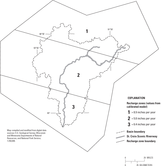
Figure 8. Recharge zones, St. Croix River Basin, Minnesota and Wisconsin.
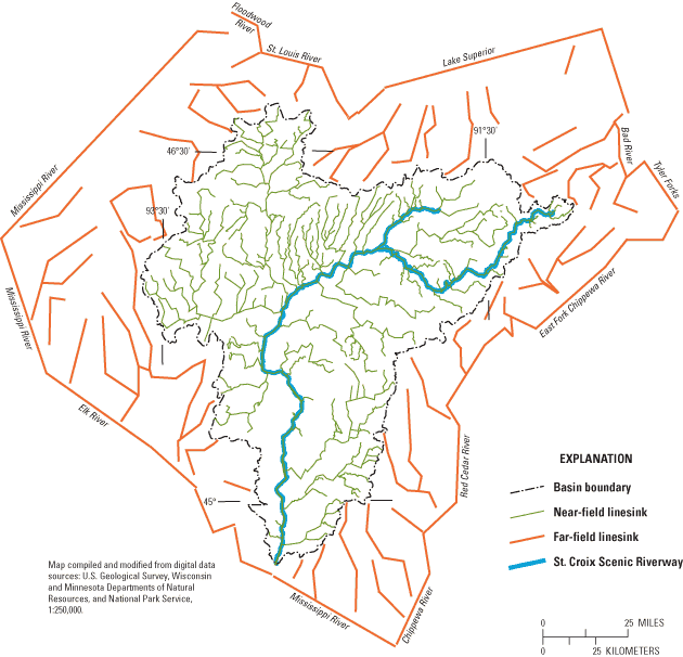
The surface-water network for the screening model consists of two domains—the near field and the far field. The near field is the area of interest, which for this study is the entire St. Croix River Basin. The far field is the area surrounding the near field that contains hydrologic features that control the ground-water flow toward or away from the near field. The function of the far field is to resolve the ground-water divides near the edge of the basin that determine, for the most part, what water is available for discharge to streams and wells within the near field.
The near-field surface-water drainage network (linesinks) for the screening model (fig. 9) consists of mostly third-order and higher streams mapped in the Minnesota and Wisconsin Department of Natural Resources' hydrography datasets at a 1:24,000 scale (Minnesota Department of Natural Resources, 2003; Wisconsin Department of Natural Resources, 2001). Downstream from the headwaters, where two second-order streams join, a larger third-order stream is formed. The St. Croix River is a sixth-order stream (Holmberg and others, 1997). The initial model input excluded streams of first order (that often flow for only part of the year) and second order (generally perennial but with small discharge) as well as all lakes, ponds, and wetlands. The far-field surface-water network is sparser than the near-field network (fig. 9); the far-field network includes eight major streams as well as large and interconnected lakes. The effective edge of the entire model corresponds to a ring of far-field surface-water bodies.
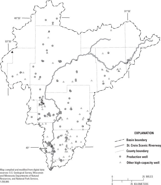
Ground-water discharge occurs not only to streams, but also to wells (fig. 10). In model simulations, discharges to wells are limited to pumping from production wells and other high-capacity wells at the average 1991–2000 discharge rates. Pumping is concentrated in the southern part of the St. Croix River Basin. The total discharge for the 1991–2000 period averages 24 Mgal/d (37 ft3/s).
The primary source of water to the ground-water-flow system is recharge to the water table. Recharge takes place nearly everywhere in the St. Croix River Basin except in ground-water discharge areas associated with surface-water bodies. Recharge rates are variable because of various factors such as differing soil percolation rates, ground slope, and relative topographic position. All other factors being equal, recharge tends to be greater where temperatures are lower and, therefore, evapotranspiration is less.
A secondary source of water to the ground-water system within the St. Croix Basin is the subsurface movement of ground water across its boundaries from neighboring basins. This source is generally not important for the shallow part of the flow system (including the unconsolidated deposits and the upper bedrock) because the topographic boundary of the basin is a good approximation of the divide that separates shallow ground water flowing within the basin from shallow ground water flowing outside the basin. However, deeper flow in Cambrian and Precambrian rocks can cross surface-water boundaries in response to gradients controlled by large sinks such as the Mississippi River or major pumping centers. Regional potentiometric surface maps, for example in the case of the Mount Simon-Hinkley aquifer systems in Minnesota, indicate the presence of long ground-water-flow paths that cross surface-water basin boundaries (Schoenberg, 1984). The one-layer screening model, although extending beyond the St. Croix Basin, does not necessarily account for all deep ground-water flow into (or out of) the basin. However, it is assumed that this cross-boundary source (or sink) of water is negligible in comparison with recharge (or discharge to streams and wells) inside the basin.
Ground-water sinks are areas or features at which water discharges from the ground-water-flow system, including surface-water features such as streams, lakes, and wetlands. Pumping wells are another type of sink, capturing ground water that would otherwise discharge to surface-water bodies. Only a small amount of the total recharge to the water table within the St. Croix River Basin is captured by wells, but certain developed areas are present within the basin where well discharge is appreciable (for example, municipalities near the St. Croix River in Washington and St. Croix Counties).
Water flows from points of recharge (sources) to points of discharge (sinks) through the ground-water-flow system. Of the recharge that enters the regional ground-water-flow system of the basin, part flows through local systems with short flow paths (usually less than about 2 mi). Local systems are common in the Quaternary till and outwash deposits and in the upper bedrock consisting of upper Ordovician and Cambrian carbonates and sandstones. Some of the water flows through a regional system with longer flow paths (on the order of tens of miles). The regional system commonly is present in bedrock consisting of lower Paleozoic sandstones as well as permeable Proterozoic rock units. Flow is largely horizontal in both local and regional systems except in regional discharge areas where ground water flows upward to surface-water sinks. The presence of major vertical fractures can also result in appreciable local vertical flow.
An analytic element ground-water-flow model was developed using the computer program GFLOW (Haitjema, 1995). The model simulates the ground-water-flow system and its interaction with surface-water features. The model consists of one layer and simulates steady-state conditions.
It is not feasible to incorporate all the complexities of the St. Croix Basin ground-water-flow system into a computer model. The necessary simplifications replace real-world conditions with a conceptual model. For a screening model, such as the one described in this report, the degree of simplification is especially great. Steps in the development of the conceptual model include: 1) definition of lithologic groups distinguished by their capability to transmit water, 2) identification of sources and sinks of water, and 3) translation of system complexities into a one-layer ground-water-flow model. The first two of these steps were accomplished by review and interpretation of available geologic and hydrogeologic data. The third step required certain simplifying assumptions with respect to the movement of water:
The advantage of the simplifications described above is that this screening model of the St. Croix River Basin (a large area consisting of all or parts of 19 counties in Minnesota and Wisconsin) can be constructed, calibrated, interpreted, and applied within a reasonable time frame (less than 2 years) in order to provide a general framework for understanding ground-water flow in the basin.
The stream network for the St. Croix River Basin (fig. 1) is represented in the AE GFLOW model as a series of mathematical sinks called linesinks (fig. 9). Multiple linesinks are joined into linesink strings representing reaches of each stream. The stream gradient (change in water-surface elevation over distance) is assigned to a linesink based on data from 7.5-minute topographic quadrangle maps. In the St. Croix River Basin screening model, linesinks are typically on the order of 3,000 ft long. GFLOW solves for the exchange between the ground water and surface water at the center of each linesink.
In the near field of the model; that is, within the St. Croix River Basin, each linesink is assigned a width based on data from 7.5-minute topographic quadrangle maps. Each near-field linesink is also assigned a resistance term that, once multiplied by the stream width and the difference between the fixed stream level and calculated water-table elevation adjacent to the stream, accounts for the ground-water flow across the streambed. The resistance is equal to the thickness of the streambed divided by its hydraulic conductivity. In the screening model, a single value of resistance equal to 0.5 day-1 (or ft/d per ft) was applied to all streams. Because of the large model scale, the water-level loss across the streambed at the end of the ground-water-flow path is generally very small relative to the water-level loss over the entire length of the flow path, and, therefore, model-simulation results are insensitive to the selected resistance value.
Near-field linesinks are linked so that streamflow is routed from near the headwaters at higher elevations through tributaries to the main trunk of streams at lower elevations. During the routing through the stream network, the amount of water captured from and lost to the ground-water-flow system by the stream is tabulated. This accounting allows the amount of water simulated in the stream at any point to be compared to flows recorded at streamflow-gaging stations. In general, streamflow consists of overland flow derived mostly from storms, and base flow derived from ground-water discharge. Only the base-flow component of streamflow is simulated with the screening model.
Linesinks also represent water bodies in the model far field outside the St. Croix River Basin (fig. 9). However, these far-field elements are assigned no resistance or width. The assigned stage for each far-field linksink is equivalent to the water-table elevation along the linesink. The far-field linesinks, therefore, act as fixed water-level conditions that serve as major sinks for ground water that discharges outside the basin. In this manner, the far-field water bodies help define the ground-water divide around the outer perimeter of the basin.
Other inputs to the GFLOW model include recharge zones, transmissivity zones, and pumping wells. The transmissivity and recharge zones extend over both the near field and far field of the model. Wells are assumed to be fully penetrating and have constant pumping rates that correspond to the average rate recorded for 1990–2000. The screening model does not account for changes in water level through time; only long-term average water levels in response to recharge and pumping are simulated.
Ground-water model calibration is a process whereby simulated values of ground-water levels and base flow are compared to observed values. Model calibration is considered complete when simulated and observed water levels and flows match closely and are considered reasonable. For this study, water levels recorded in 5,058 shallow wells (less than 100-ft deep) provided calibration targets assumed to correspond to water-table altitudes (fig. 11). The database of water levels in shallow wells is given in appendix D. The calibration targets are the average of water-level altitudes recorded from 1988 through 2000 for each well. The water-level altitudes were mapped to show the water-table surface over the St. Croix River Basin (fig. 12a). The Namekagon and St. Croix Rivers constitute the major discharge zones where the water-level altitude is lowest. However, the map of observed altitudes also shows, within the constraints of available data, the complex pattern of high and low water-level altitudes in areas away from the major streams that result from the effective combination of topography and hydraulic conductivity of the lithologic groups.
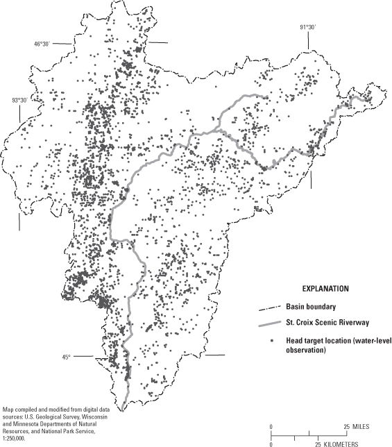
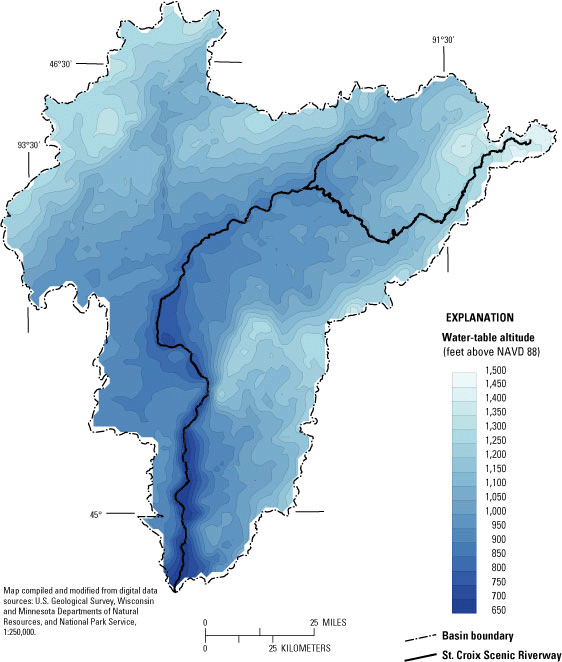

Figure 12b. Simulated water-table altitude, St. Croix River Basin, Minnesota and Wisconsin.
USGS streamflow-gaging stations provided 22 records of streamflow used to quantify target flows for model calibration (fig. 13). The database for streamflow-gaging stations is included in appendix E. The streamflow records vary in length from 1 to 100 years and average 34 years. Because only ground-water flow is simulated in the model, the entire quantity of flow in a stream is not accounted for in model simulations; only the base-flow component attributable to ground-water discharge is accounted for. One way to estimate base flow from streamflow is to rank all daily streamflow data according to size, then produce a graph that relates a given streamflow value to the amount of time over the period of record for which that flow is exceeded. Water studies in Wisconsin indicate that base flow commonly lies between the Q80 (streamflow exceeded 80 percent of the time) and the Q50 (streamflow exceeded 50 percent of the time) flow durations (Kelson and others, 2002). In general terms these statistics indicate that ground-water discharge accounts for all the water in the stream during periods of low flow amounting to half of the year or less. These periods are when runoff from rain and snowmelt is not an appreciable component of streamflow. In areas dominated by surficial coarse-grained sediments (fig. 3), base flow tends to approach the Q50 streamflow. In areas with surficial fine-grained sediments, base flow is lower and tends to approach the Q80 streamflow.
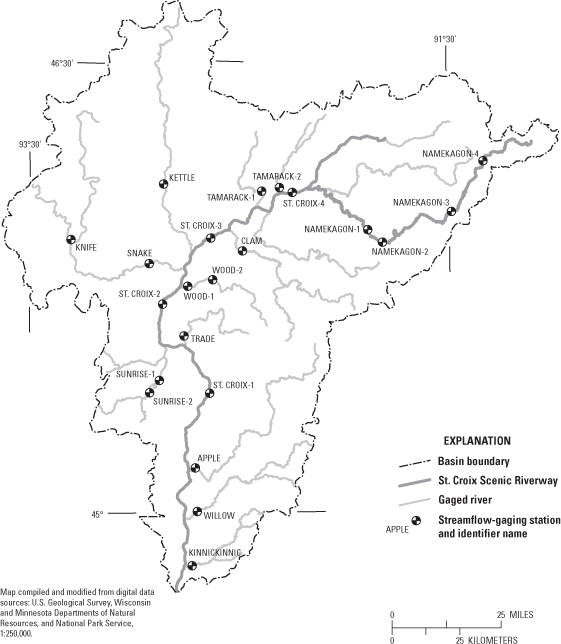
Figure 13. Locations of streamflow-gaging stations, St. Croix River Basin, Minnesota and Wisconsin.
The model was calibrated using parameter-estimation techniques based on inverse modeling. The use of inverse models for calibration generally began in the early 1990's. There are numerous publications describing the uses and advantages of inverse models (for example, Poeter and Hill, 1998; Hill 1998). Briefly, the primary benefit of a properly constructed inverse model is the capacity to automatically calculate parameter values (for example, transmissivity and recharge) that provide a quantified best-fit between simulated and observed data (for example, ground-water levels and stream base flow). Other benefits include calculation of parameter sensitivity and strength of correlation between parameters. In this study, the GFLOW model was coupled to the inverse code UCODE (Poeter and Hill, 1998). The simultaneous consideration of water-level and base-flow targets enhances the ability to arrive at a definite solution for water levels and ground-water flow because the tendency for recharge and transmissivity to be correlated is overcome. Therefore, both recharge and transmissivity can be estimated with confidence.
An important input to the inverse model is the selection of the weight given to each observed data point. For simulations with the screening model, greater weights were assigned to base-flow targets than water-level targets because base flows integrate hydrogeologic conditions over the entire model domain. The weights were adjusted so that the set of 22 base-flow targets and the set of 5,058 water-level targets are about equal in determining parameter values through the inverse procedure. The largest weights are assigned to the more downstream base-flow targets because large flows at these targets integrate ground-water discharge from a disproportionately large part of the basin, and therefore, these flows have the largest effect in determining the overall model-simulated ground-water recharge.
Based on inverse modeling, the conceptual model of the ground-water-flow system described previously was changed in three major ways:
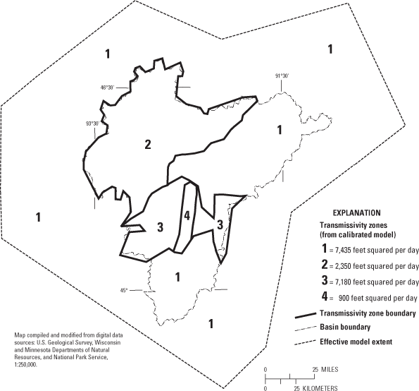
Calibrated values for zones of recharge and transmissivity are based on UCODE inverse modeling and are shown in figures 8 and 14, respectively. The parameter estimation results are also listed in table 2.
| Parameter and zone | Value |
|---|---|
| Transmissivity (feet squared per day) | |
| Zone 1 | 7,435 |
| Zone 2 | 2,350 |
| Zone 3 | 7,180 |
| Zone 4 | 900 |
| Recharge (inches per year) | |
| Zone 1 (northern) | 8.9 |
| Zone 2 (middle) | 5.8 |
| Zone 3 (southern) | 6.4 |
The inverse model results generally agree with the initial conceptual model for the ground-water-flow system in the St. Croix River Basin. Transmissivity Zone 1 corresponds to the area with the greatest thickness of lithologies with higher hydraulic conductivity as determined from well logs. The transmissivity value of Zone 1 is considerably higher than that estimated for Zone 2; Zone 2 is underlain primarily with lower conductivity lithologic groups. Zone 3 is underlain by both higher and lower conductivity lithologic groups with a transmissivity similar to Zone 1. The additional transmissivity zone based on model calibration (Zone 4 in Polk County) encompasses a strip of low-permeability basalt and rhyolite with relatively thin overlying unconsolidated material. The zone corresponds to the area with the lowest transmissivity.
UCODE generates a recharge value in the northern recharge zone that is appreciably higher than the two other recharge zones. It is likely that this finding reflects low evapotranspiration rates in the northern zone resulting in more water available for infiltration. The calibrated recharge value for the southern zone is slightly larger than the middle recharge zone; it is likely that factors other than evaporation potential (for example, permeability of near-surface deposits) are important in determining overall recharge rates.
As discussed previously, the observed water-table altitudes are presented in figure 12a. Simulated water-table attributes are presented in figure 12b. Comparison of these figures indicates that the model-simulated water-table surface is similar in shape to the observed surface, and also similar in detailed features such as the location of the ground-water divide in Polk County. A more specific comparison between observed and simulated results is accomplished by comparing the difference between observed and simulated water levels, called residuals. Observed and simulated water levels at calibration targets are shown in figure 15. The mean error (equal to the average residual) is about 10 ft, indicating that, on average, the simulated water levels were too low. The mean absolute error (equal to the average of the absolute value of residuals) is about 30 ft, which is equal to an acceptable 3.8 percent of the range between the minimum (671 ft above NAVD 88) and maximum (1,465 ft) observed water levels. The root-mean square error (a measure of fit that gives more weight to large residuals) is about 42 ft, which is equal to an acceptable 5.3 percent of the observed water-level range. The correlation coefficient between the observed and simulated water levels is 0.95, indicating a reasonably good fit.
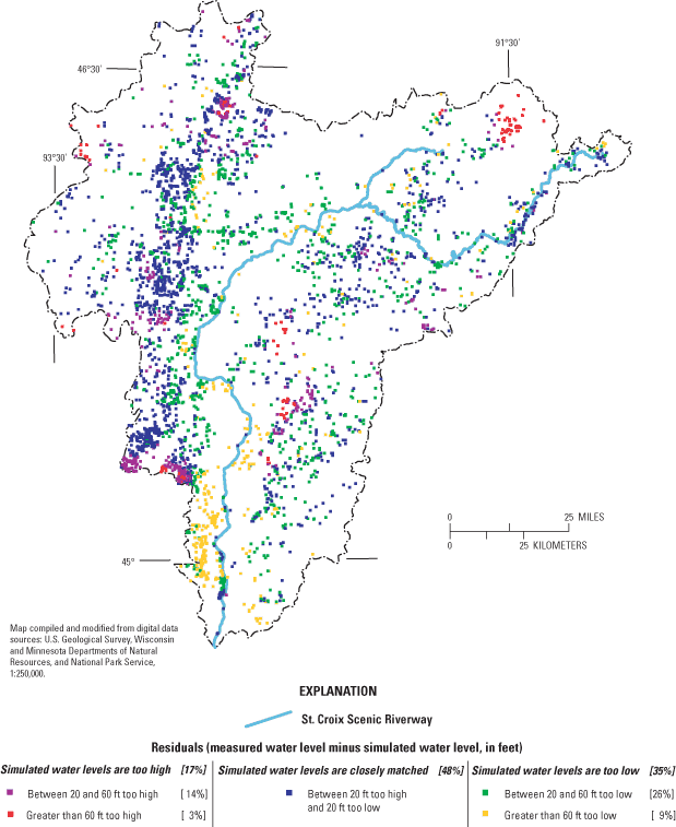
The distribution of residuals shows a good match between observed and simulated water levels throughout most of the basin (fig. 16). However, model-simulated water levels are too low along the St. Croix River in the southern part of the basin. One possibile explanation for the large residuals in this area is that springs and other discharge features, located at the higher altitudes of the valleys incised by the St. Croix River, determine the regional altitude for ground water in these areas. Because river elevation is used in model simulations as the discharge outlet, it is possible that the model contains a bias that is reflected in the large positive residuals (simulated water levels too low). Focused studies of ground-water conditions in Washington, St. Croix, and Polk Counties would be needed to determine how the altitude of discharge features affects the observed water table.
The agreement between estimates of base flow based on streamflow records and base flow simulated in the model is generally good (fig. 17). A comparison of observed and simulated base flow at individual stations is given in table 3. The agreement is particularly good for the stations along the St. Croix River with the largest estimated base flows.
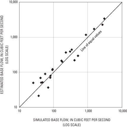
Figure 17. Model-simulated and estimated base flows, St. Croix River Basin, Minnesota and Wisconsin.
[estimated base flow is equivalent to the Q50 flow (streamflow exceeded 50 percent of the time) at the streamflow-gaging station]
| Streamflow-gaging station | Estimated base flow, in cubic feet per second | Simulated base flow, in cubic feet per second |
|---|---|---|
| St Croix -1 | 3,388 | 3,033 |
| St Croix -2 | 2,259 | 2,684 |
| St Croix -3 | 1,718 | 1,523 |
| St Croix -4 | 1,167 | 878 |
| Namekagon -1 | 439 | 340 |
| Namekagon -2 | 390 | 302 |
| Apple | 369 | 228 |
| Kettle | 297 | 515 |
| Snake | 221 | 411 |
| Clam | 214 | 169 |
| Namekagon -3 | 201 | 178 |
| Willow | 122 | 94 |
| Namekagon -4 | 116 | 93 |
| Kinnickinnic | 90 | 57 |
| Tamarack -1 | 79 | 81 |
| Sunrise -1 | 71 | 81 |
| Trade | 69 | 42 |
| Tamarack -2 | 52 | 48 |
| Wood -1 | 50 | 44 |
| Wood -2 | 50 | 26 |
| Sunrise -2 | 37 | 70 |
| Knife | 21 | 37 |
The Q50 flow estimate at station St. Croix River-1 is 3,388 ft3/s; the simulated value is 3,033 ft3/s. This station is the last calibration target above the outlet of the St. Croix to the Mississippi River, accumulating ground-water discharge over most of the basin.
All ground-water models are simplifications of actual ground-water systems and have corresponding limitations in model accuracy, precision, and application. The analytic-element screening model presented in this report is intended to be a coarse instrument for analyzing ground-water-flow conditions. Heterogeneities in subsurface properties and in recharge rates were considered only at a very broad scale in this study. No account is taken of vertical variations in hydrologic properties or pumping rates, and no provision is made to account for stacked aquifers and confining units with different flow patterns at different depths. Small-scale local flow systems associated with minor first-order streams, as well as lakes, wetlands, and springs, are neglected. Despite these limitations, the model can be used to simulate reliable water balances for ground-water flow at the basin scale as long as reasonable recharge rates, streams of second order and greater, and regional trends in transmissivity can be incorporated.
A disadvantage of the screening model approach is that the model has limited usefulness for addressing some site-specific questions. The screening model should not be used to determine how deeper parts of the flow system respond to pumping from a cluster of wells below confining units (typically laterally continuous, low-hydraulic conductivity layers such as shale) where the confined potentiometric surface does not necessarily follow the gradient of the shallow water table. The screening model should also not be used to study how a local flow system around a stream, lake, or spring is affected by small-scale land-use changes. As a result of the simplifying assumptions of the screening model, the observed water-table trends cannot be accurately simulated everywhere in the model domain because local-scale, but still important, features are neglected. For example, springs along the walls of river valleys or abrupt changes in the thickness of permeable deposits are not taken into account.
Limitations particular to this model of the St. Croix River Basin include the following:
Many of the limitations of the screening model affect the ability to simulate conditions in specific areas of concern, which would be needed to address problems related to water supply and water quality. The construction of the screening model is a first step in an approach that builds on the availability of a large-scale, two-dimensional model to provide inputs and boundary conditions for smaller-scale three-dimensional models containing more detailed heterogeneity and a more detailed surface-water network (Dunning and others, 2004; Feinstein and others, 2003). The St. Croix River Basin ground-water screening model is designed to be used in providing input for possible future three-dimensional models. The limitations of the screening model points to areas for possible future research, which include the effect of valley walls and springs in controlling the regional discharge elevation along the St. Croix River, and the effect of subcrops of crystalline bedrock in controlling the location of important ground-water divides.
The databases and screening model for the St. Croix River Basin integrate information over a large scale. The databases and model form a basis for possible future studies that could focus on different parts of the basin, adding to the assembled information and framework to address site-specific problems. Because the screening model was constructed at a large scale, the model should only be applied to ground-water issues at a regional scale. Two aspects of the ground-water-flow system to which the model can be appropriately applied are:
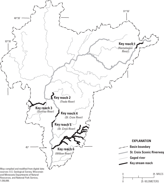
The National Park Service has identified stream reaches for six watersheds within the St. Croix River Basin that are of special concern with respect to water quality or ecological health (Randy Ferrin, National Park Service, oral commun., 2004). The stream reaches shown in figure 18 are (from north to south):
A technique called reverse particle tracking (Pollock, 1994) was used to identify the areas from which ground water entered the subsurface as recharge and circulated to these key reaches. Reverse particle tracking simulates the movement of imaginary particles through the ground-water-flow system as pathlines from the discharge point at the river backward to the water-table location where recharge occurred. When many pathlines are simulated, it is possible to delineate the entire area that contributes base flow to a specified stream reach. The contributing area for the trout-breeding reach (Key Reach 1) of the Namekagon River is shown in figure 19a. The contributing areas for the key reaches of the Trade (2), Sunrise (3), and St. Croix Rivers (4 and 5) are shown in figure 19b. The contributing area for the Willow River (6) is shown in figure 19c.
In the cases presented in figures 19b and 19c, the boundaries of the simulated ground-water contributing areas that extend toward the edge of the St. Croix River Basin are largely coincident with the surface-water boundaries that define the basin. However, ground-water and surface-water divides do not always coincide. Geologic factors, as well as pumping, can cause the location of ground-water and surface-water divides to differ. In the case of the contributing area to the Namekagon River (fig. 19a) at the north end of the basin, the simulated ground-water divide lies to the east of the surface-water divide. Further study (at a more local scale than possible with the screening model) would be needed to determine more precisely the degree to which the ground-water basin extends under neighboring surface-water divides as well as to simulate more precisely the extent of contributing areas within the St. Croix Basin.
Ground water travels from the water table to streams and wells at a velocity that is controlled by the hydraulic gradient, the transmissivity and thickness of the ground-water-flow system, and the effective porosity along the pathline. The length of a pathline segment is divided in GFLOW by the average ground-water velocity over the segments, then the results are summed to calculate the total time of travel from recharge to discharge points. The effective porosity was assumed to be 10 percent in the entire model domain, a value that is intermediate between the higher values associated with sands, typically around 20 percent, and the lower values associated with fine-grained unconsolidated deposits and bedrock stratigraphic units (figs. 3 and 4), typically around 5 percent (Freeze and Cherry, 1979). Particles were released on 1.5-mi centers across the entire basin and tracked forward from the water table. The time-of-travel from the water table to the discharge point at a stream or well was recorded for each particle. Given the parameter assumptions, calculated travel times are associated with a large range of uncertainty (from half to twice the simulated value).
The median calculated time of travel for ground-water pathlines, most of which terminate at streams, is 50 years (corresponding to an uncertainty range of 25 to 100 years). Ninety percent of the pathlines require travel times between 3 and 260 years (corresponding to an uncertainty range of 1 to 500 years). The median distance traversed was calculated to be 1.7 mi and the median velocity was 177 ft/yr (corresponding to an uncertainty range of 90 to 350 ft/yr). Areas where the ground-water flow from the water table to the discharge point (generally a stream) was relatively rapid (generally less than 50 years) are shown in figure 20. Shaded areas correspond to simulated ground-water travel times that are less than the calculated median time of travel (on the order of 50 years).
The St. Croix River Basin, which includes all or parts of 19 counties in Minnesota and Wisconsin, is an area rich in hydrologic resources that is, in places, undergoing rapid development. This study by the U.S. Geological Survey, in cooperation with the National Park Service, is intended to contribute to a fundamental understanding of the region's hydrogeology. Multiple series of geologic and hydraulic data were compiled and a large-scale ground-water-flow model was constructed to provide a hydrogeologic framework for the basin.
The data series include information on well logs, lithology, thickness of lithologic groups, ground-water levels, streamflow, and well pumpage. Much of the information is summarized in maps that show the distribution of lithologic groups distinguished by their capacity to transmit water. Detailed tabulated data are available in the appendixes to this report.
The model is a coarse screening tool where the analytic-element code GFLOW is applied to the movement of ground water from recharge areas in the basin to discharge sites at streams and production wells. To represent subsurface complexity in the screening model, it is more useful to characterize the ground-water-flow system in terms of broad lithologic groups rather than by individual stratigraphic formations or hydrogeologic units such as aquifers and confining units. The model is calibrated both to the water-table surface and to base-flow estimates at 22 streamflow-gaging stations throughout the basin. The agreement between observed and simulated water levels and between observed and simulated base flows was generally good as shown by calibration statistics and plots.
Heterogeneities in subsurface properties and in recharge rates were considered only at a very broad scale in this study. No account was taken of vertical variations in hydrologic properties or pumping rates. The model should not be used to simulate site-specific problems related to water supply and water quality. In addition, the screening model should not be used to study how a local flow system around a stream, lake, or spring is affected by small-scale land-use changes.
Simulated results show ground-water contributing areas for key stream reaches within the basin. The delineation of these areas is useful to water-resources managers concerned with protection of fisheries and other resources. The model-simulation results also identify the areas of the basin where ground-water travel time from the water table to streams and wells is less than the median time of travel for all ground water in the basin, which is calculated to be 50 years with an uncertainty range of 25 to 100 years. Ninety percent of the simulated ground-water pathlines require travel times between 3 and 260 years. The median pathline distance traversed and the median pathline velocity is 1.7 mi and 177 ft/y, respectively.
Besides serving as a framework for understanding ground-water flow in the basin, the model can serve as a starting point for a generation of more targeted ground-water models. The screening model is a first step in an approach that builds on the availability of a large-scale regional model to provide inputs and boundary conditions for smaller-scale, three-dimensional models. The combination of regional and local models provides a comprehensive tool that could be used by water-resources managers to address emerging water-supply and water-quality concerns in the St. Croix River Basin.
The authors acknowledge the contributions of the following people and organizations: Randy Ferrin of the National Park Service, St. Croix Scenic Riverway, was instrumental in defining the scope and objectives of the study, and provided guidance throughout the course of the study. Gregory Mitton of the U.S. Geological Survey Minnesota Water Science Center provided substantial assistance in generating the streamflow-duration analysis for the Minnesota streamflow-gaging stations. Robert Tipping and Timothy Wahl of the Minnesota Geological Survey provided geologic well log data, as well as data and resources pertaining to the hydrostratigraphic and hydraulic characterization of Minnesota. Tom Gullet of the Minnesota Department of Natural Resources supplied critical data relating to the Observation Well Network, and Sean Hunt, also of the Minnesota Department of Natural Resources, provided information about the Water Appropriation Permit Program and the annual water-use report. Kenneth Bradbury, David LePain, and Bruce Brown of the University of Wisconsin–Extension, Wisconsin Geologic and Natural History Survey provided invaluable technical assistance and advice relating to many aspects of the hydrogeology of northwestern Wisconsin. Their expertise and support of the study are greatly appreciated. Randell Clark of the Wisconsin Department of Natural Resources provided assistance in making use of many of the databases that provided critical data on well construction, subsurface geology, and well pumpage.
Austin, G.S., 1969, Paleozoic lithostratigraphic nomenclature for southeastern Minnesota: Minnesota Geological Survey, Information Circular 6, 11 p.
Bakker, M., Anderson, E.I., Olsthoorn, T.N., and Strack, O.D.L., 1999, Regional groundwater modeling of the Yucca Mountain site using analytic elements: Journal of Hydrology, v. 226, p. 167–178.
Borman, R.G., 1976, Ground-water resources and geology of St. Croix County, Wisconsin: Wisconsin Geological and Natural History Survey, Information Circular 32, 30 p. and 1 plate.
Cannon, W.F., Kress, T.H., Sutphin, D.M., Morey, G.B., and Meints, J., 1997, Digital geologic map and mineral deposits of the Lake Superior Region: U.S. Geological Survey Open-File Report 97-455, scale 1:1,000,000, additional GIS data added in 1999, accessed March 24, 2006, at https://pubs.usgs.gov/of/1997/of97-455/
Delin, G.N., Healy, R.W., Landon, M.K., and Bohlke, J.K., 2000, Effects of topography and soil properties on recharge at two sites in an agricultural field: Journal of the American Water Resources Association, v. 36, no. 6, p. 1401–1416.
Dott, R. H., Jr., and Attig, J.W., 2004, Roadside geology of Wisconsin: Missoula, MT, Mountain Press Publishing Co., 359 p.
Dunning, C.P., Feinstein, D.T., Hunt, R.J., and Krohelski, J.T., 2004, Simulation of ground-water flow, surface-water flow, and a deep sewer tunnel system in the Menomonee Valley, Milwaukee, Wisconsin: U.S. Geological Survey Scientific Investigations Report 2004–5031, 40 p.
Dunning, C. P., Thomas, J.C., and Lin, Y., 2003, Simulation of the shallow ground water system in the vicinity of Silver Lake, Wisconsin, using analytic elements: U.S. Geological Survey Water-Resources Investigations Report 02–4204, 36 p.
Fallon, J.D., and McNellis, R.P., 2000, Nutrients and suspended sediment in snowmelt runoff from the Upper Mississippi River Basin, Minnesota and Wisconsin, 1997: U.S. Geological Survey Water-Resources Investigations Report 9941–65, 23 p.
Feinstein, D.T., Dunning, C.P., Hunt, R.J., and Krohelski, J.T., 2003, Stepwise use of GFLOW and MODFLOW to determine relative importance of shallow and deep receptors: Ground Water v. 41, n. 2, p. 190–199.
Freeze, R.A., and Cherry, J.A., 1979, Groundwater: Prentice-Hall, NJ, 604 p.
Haitjema, H.H., 1995, Analytic element modeling of groundwater: Academic Press. NY, 394 p.
Hill, M.C., 1998, Methods and guidelines for effective model calibration: U.S. Geological Survey Water Resources Investigations Report 98–4005, 90 p.
Holmberg, K.L., Perry, J., Ferrin, R.S., and Sharrow, D.L., 1997, St. Croix National Scenic Riverway, Minnesota and Wisconsin: National Park Service Water Resources Management Plan, February 1997, 402 p.
Hunt, R.J., Saad, D.A., and Chapel, D.M., 2003, Numerical simulation of ground-water flow in La Crosse County and into nearby pools of the Mississippi River: U.S. Geological Survey Water-Resources Investigation Report 03–4154. 44 p.
Hunt, R.J., Lin Y-F, Krohelski, J.T., and Juckem, P.F., 2000, Simulation of the shallow hydrologic system in the vicinity of Middle Genesee Lake, Wisconsin, using analytic elements and parameter estimation: U.S. Geological Survey Water-Resources Investigations Report 00–4136, 16 p.
Hunt, R.J., Anderson, M.P., and Kelson, V.A., 1998, Improving a complex finite-difference ground water flow model through the use of an analytic element screening model: Ground Water, v. 36, no. 6, p. 1011–1017.
Kelson, V.A., Hunt, R.J., and Haitjema, H.M., 2002, Improving a regional model using reduced complexity and parameter estimation. Ground Water, v. 40, no. 2, p. 138–149.
Kammerer, P.A.; Trotta, L.C.; Krabbenhoft, D.P., and Lidwin, R.A., 1998, Geology, ground-water flow, and dissolved-solids concentrations in ground water along hydrogeologic sections through Wisconsin aquifers: U.S. Geological Survey Hydrologic Investigations Atlas HA–731, 4 sheets.
Lenz, B.N., Roberson, D.M., Fallon, J.D., and Ferrin, R., 2001, Nutrient and suspended-sediment concentrations and loads and benthic-invertebrate data for tributaries to the St. Croix River, Wisconsin and Minnesota, 1997–99: U.S. Geological Survey Water-Resources Investigations Report 01–4162, 57 p.
Lindholm, G.F., Helgesen, J.O., Broussard, W.L., and Ericson, D.W., 1974, Water resources of the Snake River Watershed, east-central Minnesota: U.S. Geological Survey Hydrologic Investigations Atlas HA-488, 3 sheets.
Lindholm, G.F., Helgesen, J.O., Broussard, W.L., and Ericson, D.W., 1973, Water resources of the Kettle River Watershed, east-central Minnesota: U.S. Geological Survey Hydrologic Investigations Atlas HA–437, 4 sheets.
Lindholm, G.F., Helgesen, J.O., Broussard, W.L., and Farrell, D.F., 1974, Water resources of the Lower St. Croix River Watershed, east-central Minnesota: U.S. Geological Survey Hydrologic Investigations Atlas HA–490, 3 sheets.
Linsley, R.K., Kohler, M.A., and Paulhus, J.L.H., 1975, Hydrology for engineers: McGraw-Hill, New York, 482 p.
Minnesota Department of Natural Resources, 2003, DNR 24K streams: Minnesota Department of Natural Resources—Management Information Services Bureau, accessed March 23, 2006, at http://deli.dnr.state.mn.us/data_catalog.html, scale 1:24,000.
Minnesota Geological Survey, 2003, County well index: University of Minnesota, version 4, CD-ROM.
Muldoon, M.A., 2000, Generalized water-table elevation map of Polk County, Wisconsin: Wisconsin Geological and Natural History Survey, Miscellaneous Map 48.
Muldoon, M.A., and Dahl, M.V., 1998, Generalized water-table elevation map of Burnett County, Wisconsin: Wisconsin Geological and Natural History Survey, Miscellaneous Map 45.
Norvitch, R.F., Ross, T.G., and Briekrietz, A., 1973, Water resources outlook for the Minneapolis – St. Paul Metropolitan Area, Minnesota: U.S. Geological Survey and Metropolitan Council of the Twin Cities, 219 p.
Paillet, F.L., Lundy, J., Tipping, R., Runkel, A., Reeves, L., and Green, J., 2000, Hydrogeologic characterization of six sites in Southeastern Minnesota using borehole flowmeters and other geophysical logs: U.S. Geological Survey Water-Resources Investigation Report 00–4142, 33 p.
Poeter, E.P. and M.C. Hill. 1998. Documentation of UCODE, a computer code for universal inverse modeling: U.S. Geological Survey Water-Resources Investigation Report 98–4080, 116 p.
Pollock, D.W., 1994, User's guide for MODPATH/MODPATH-PLOT, version 3; a particle tracking post-processing package for MODFLOW, the U.S. Geological Survey finite-difference ground-water flow model: U.S. Geological Survey Open-File Report 94–464, 248 p.
Runkel, A.C., 2003, A regional-scale hydrostratigraphically-based characterization of a heterogeneous sedimentary aquifer system, in Construction of a new hydrogeologic framework for paleozoic strata in the northern midcontinent, North America: Geological Society of America Proceedings, Paper No. 20–6.
Runkel, A.C., 2000, Minneosta at a glance: Minnnesota Geological Survey, 4 p.
Schoenberg, M.E., 1984, Water levels and water-level changes in the Prairie du Chien-Jordan and Mount Simon-Hinkley aquifers, Twin Cities metropolitan area, Minnesota, 1971–1980: U.S. Geological Survey Water-Resources Investigations Report 83–4237, 23 p.
Schwarz, G.E., and Alexander, R.B., 1995, State Soil Geographic (STATSGO) data base for the conterminous United States: U.S. Geological Survey Open-File Report 95–449.
Seaberg, J., 2000, Overview of the Twin Cities metropolitan groundwater model: Minnesota Pollution Control Agency, 65 p.
Soller, D.R., 1992, Text and references to accompany "Map showing the thickness and character of Quaternary sediments in the glaciated United States east of the Rocky Mountains": U.S. Geological Survey Bulletin 1921, 71 p.
Soller, D.R., and Packard, P.H., 1998, Digital representation of a map showing the thickness and character of Quaternary sediments in the glaciated United States east of the Rocky Mountains: U.S. Geological Survey Digital Series DDS–38
Strack, O. D. L., 1989, Groundwater mechanics: Prentice-Hall, Englewood Cliffs, NJ, 732 p.
Swanson, L., and Meyer, G.N., eds., 1990, Geologic atlas of Washington County, Minnesota: University of Minnesota, Minnesota Geological Survey, 7 sheets.
U.S. Geological Survey, 2002, National Hydrography Dataset (NHD)—High-resolution (NHDinARC schema version 1.04), accessed November 12, 2002, at http://nhd.usgs.gov/, scale 1:24,000.
U.S. Geological Survey, National Water Information System (NWIS), accessed November 20, 2002, at http://waterdata.usgs.gov/nwis/
U.S. Geological Survey, 2001, National Elevation Dataset (NED) 30-meter Digital Elevation Models (DEMs): National Mapping Division, accessed November 8, 2002, at http://gisdata.usgs.net/NED, scale 1:24,000.
U.S. Geological Survey and U.S. Environmental Protection Agency, 1999, National Hydrography Dataset (NHD), accessed November 19, 2002, at http://nhd.usgs.gov, scale 1:100,000.
Wisconsin Department of Natural Resources, 2001, Wisconsin DNR 24K hydrography database, version 2: Wisconsin Department of Natural Resources, Bureau of Enterprise Information and Applications, scale 1:24,000.
Young, H.L. and Hindall, S.M., 1973, Water Resources of Wisconsin, St. Croix River Basin: U.S. Geological Survey Hydrologic Investigations Atlas HA–451, 4 sheets.
The following appendixes are available for download as a zip file (1,293 KB). The "README.txt" file provides information on how to use the appendix data.
Appendix A. Well Logs
Appendix B. Lithology
Appendix C. Thickness of Lithologic Groups
Appendix D. Ground-Water Levels
Appendix E. Streamflow
Appendix F. Well Pumpage
Document Accessibility: Adobe Systems Incorporated has information about PDFs and the visually impaired. This information provides tools to help make PDF files accessible. These tools convert Adobe PDF documents into HTML or ASCII text, which then can be read by a number of common screen-reading programs that synthesize text as audible speech. In addition, an accessible version of Adobe Reader, which contains support for screen readers, is available. These tools and the accessible reader may be obtained free from Adobe at Adobe Access.
| AccessibilityFOIAPrivacyPolicies and Notices | |
| U.S. Department of the Interior, U.S. Geological Survey
Persistent URL: https://pubs.water.usgs.gov/sir20055283 Page Contact Information: Publications Team Page Last Modified: Thursday, 01-Dec-2016 18:52:51 EST |
 |
