 |
|
|
||||
| Scientific Investigations Report 2006-5050 |
Vulnerability of Recently Recharged Ground Water in the High Plains Aquifer to Nitrate ContaminationBy Jason J. Gurdak and Sharon L. QiThis document is available in pdf format:
The citation for this report, in USGS format, is as follows:
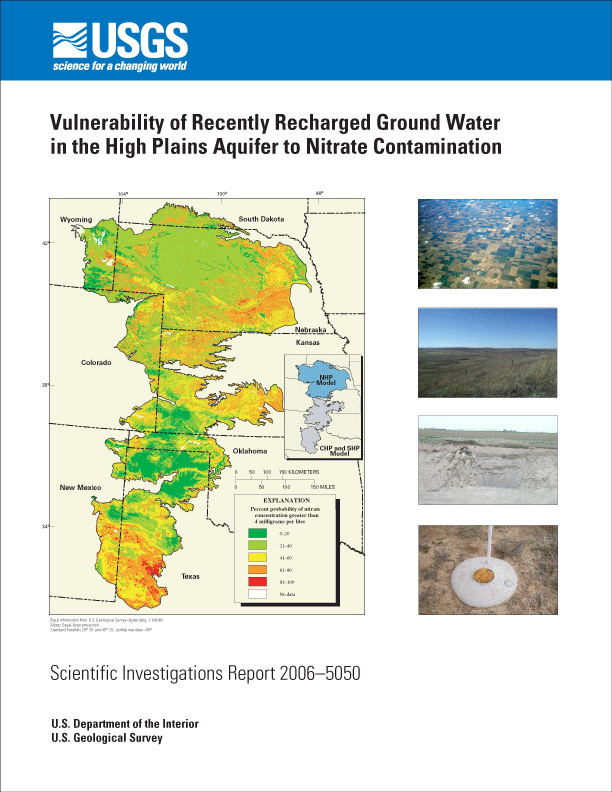
AbstractNitrate concentrations greater than background levels have been detected in ground water of the High Plains aquifer. Empirically based models and corresponding maps were developed that predict the vulnerability of the aquifer to nonpoint-source nitrate contamination. The models predict the probability of detecting nitrate concentrations larger than 4 milligrams per liter in ground water of the High Plains aquifer that was recharged during the last 50 years. The models were calibrated by correlating concentrations of nitrate in ground water from 336 wells that intercept recently recharged (less than 50 years) water with anthropogenic and hydrogeologic explanatory variables. Particle-tracking simulations delineated well-contributing areas and determined well-screen depths that intercept recently recharged ground water. The models were developed using multivariate logistic regression, and a map was generated from these models using a geographic information system. Two multivariate logistic regression models of vulnerability were found to have the most statistical significance and the best model fit and predictive ability. The two models represent the Northern High Plains and the combined Central and Southern High Plains, and they indicate that ground-water vulnerability of the entire High Plains aquifer is best explained by the spatial distribution of nonirrigated and irrigated agricultural lands, organic matter of the soil, depth to the regional water table, and clay content of the unsaturated zone. Vulnerability of the Northern High Plains is greater in areas that have more nonirrigated and irrigated agricultural lands and less organic matter in the soil. The vulnerability of the Central and Southern High Plains also is greater in areas that have more nonirrigated and irrigated agricultural lands and also in areas with shallow depths to water table and less clay in the unsaturated zone. The majority (53.3 percent) of the High Plains aquifer has less than a 40-percent predicted probability of nitrate concentrations larger than 4 milligrams per liter. Approximately 21.1 percent of the High Plains aquifer has a relatively high (greater than 60 percent) predicted probability of nitrate concentrations greater than or equal to 4 milligrams per liter. Areas with relatively high predicted probability are located in the southwestern, southern, and eastern areas of the Northern High Plains, in the eastern arm of the Central High Plains, and in southern areas of the Southern High Plains. Areas of the aquifer with relatively low (less than 40 percent) predicted vulnerability to nitrate concentrations greater than or equal to 4 milligrams per liter are located in the northwestern and north-central areas of the Northern High Plains, the central and southern areas of the Central High Plains, and a band across the north-central part of the Southern High Plains. Uncertainty of these vulnerability predictions was estimated by Latin hypercube sampling to address propagation of model and data errors inherently associated with estimates of model coefficients and explanatory variables. Results of the Latin hypercube sampling simulations are presented as uncertainty maps of the lower 5th and upper 95th percentile of the output probability distribution, which represents the 90-percent prediction interval that contains the true probability of detecting nitrate greater than or equal to 4 milligrams per liter. Generally, these uncertainty maps show greater prediction uncertainty in areas with relatively higher predicted vulnerability and lower uncertainty in areas with relatively lower predicted vulnerability. Table of ContentsAbstract Introduction Background Purpose and Scope Acknowledgments Description of Study Area Geohydrologic Setting Land and Water Use Methods of Investigation Defining Recently Recharged Ground Water and Delineating Contributing Areas Simulation of Ground-Water Flow and Particle Tracking Model Discretization, Boundary Conditions, and Model Stresses Model Simulation and Sensitivity Analysis Compilation of Ground-Water-Quality, Anthropogenic, and Hydrogeologic Data Ground-Water-Quality Data Establishing Relative Background Concentration of Nitrate Anthropogenic Data Hydrogeologic Data Explanatory Variable Extraction Statistical Methods Uncertainty Estimation Estimating the Probability of Nitrate in Ground Water Exceeding the Relative Background Concentration Development of Nitrate Model Validation of Nitrate Model Construction of Nitrate Probability and Uncertainty Maps Vulnerability of Recently Recharged Ground Water to Nitrate Contamination Appropriate Uses of the Probability and Uncertainty Maps Summary References Cited |
|
|
| AccessibilityFOIAPrivacyPolicies and Notices | |
| U.S.
Department of the Interior, U.S. Geological
Survey Persistent URL: https://pubs.water.usgs.gov/sir20065050 Page Contact Information: Publications Team Page Last Modified: Thursday, 01-Dec-2016 19:02:06 EST |
 |