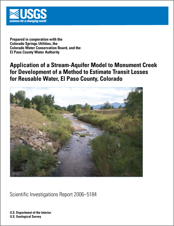
Application of a Stream-Aquifer Model to Monument
Creek for Development of a Method to Estimate Transit Losses for Reusable
Water, El Paso County, Colorado
By Gerhard Kuhn and L. Rick Arnold
Available from the U.S. Geological Survey, Branch of Information
Services, Box 25286, Denver Federal Center, Denver, CO 80225, USGS
Scientific Investigations Report 2006-5184, 111 p., 33 figs.
This document also is available in pdf format:  SIR2006-5184 (9.64
MB) SIR2006-5184 (9.64
MB)
(Requires Adobe
Acrobat Reader)
The citation for this report, in USGS format, is as follows:
Kuhn, Gerhard and Arnold, L.R., 2006, Application of a Stream-Aquifer
Model to Monument Creek for Development of a Method to Estimate Transit
Losses for Reusable
Water, El Paso County, Colorado:
U.S.
Geological Survey Scientific Investigations Report 2006-5184, 111 p.
Abstract
The U.S. Geological Survey, in cooperation with Colorado
Springs Utilities, the Colorado Water Conservation Board, and the El
Paso County Water Authority, began a study in 2004 to (1) apply a stream-aquifer
model to Monument Creek, (2) use the results of the modeling to develop
a transit-loss accounting program for Monument Creek, (3) revise the
existing transit-loss accounting program for Fountain Creek to incorporate
new water-management strategies and allow for incorporation of future
changes in water-management strategies,
and (4) integrate the two accounting programs into a single program with
a Web-based user interface. The purpose of this report is to present
the results of applying a stream-aquifer model to the Monument Creek
study reach.
Transit losses were estimated for reusable-water flows in Monument Creek
that ranged from 1 to 200 cubic feet per second (ft3/s) and for
native streamflows that ranged from 0 to 1,000 ft3/s. Transit losses
were estimated for bank-storage, channel-storage, and evaporative losses.
The same stream-aquifer model used in the previously completed (1988) Fountain
Creek study was used in the Monument Creek study.
Sixteen model nodes were established for the Monument Creek study reach,
defining 15 subreaches. Channel length, aquifer length, and aquifer width
for the subreaches were estimated from available topographic and geologic
maps. Thickness of alluvial deposits and saturated thickness were estimated
using lithologic and water-level data from about 100 wells and test holes
in or near the Monument Creek study reach. Estimated average transmissivities
for the subreaches ranged from 2,000 to 12,000 feet squared per day,
and a uniform value of 0.20 was used for storage coefficient.
Qualitative comparison of recorded and simulated streamflow at the downstream
node for the calibration and verification simulations indicated that
the two streamflows compared reasonably well. No adjustments were made
to the model parameters. Differences between recorded and simulated streamflow
volumes for all calibration and verification
simulations ranged from about –8.8 to 7.5 percent; the total error
for all simulations was about –0.7 percent.
The model was used to estimate bank-storage losses for
10 to 15 native streamflows for each reusable-water flow of 1, 3, 5,
7, 10, 15, 20, 30,
40, 50, 100, and 200 ft3/s. Then the 10 to 15 bank-storage loss values
were used in least-squares linear
regression to estimate a relation between bank-storage loss and native
streamflow for each of the 12 reusable-water flow rates. The 12 regression
relations then were used to develop “look-up” tables of bank-storage
loss for reusable-water flows ranging from 1 to 200 ft3/s (in 1-ft3/s
increments). Additional model simulations indicated that (1) when the
ratio of downstream
native streamflow to upstream native streamflow was less than 1, bank-storage
loss generally increased and (2) when the ratio of downstream native
streamflow to upstream native streamflow was larger than 1, bank-storage
loss generally decreased. These results were used to develop a bank-storage
loss adjustment factor based on the ratio of native streamflow at the
downstream node to native streamflow at the upstream node. The model
also was used to estimate a recovery period, which is the length of time
needed for the bank-storage loss to return to the stream. The recovery
period was 1 day for six subreaches; 2 days for four subreaches; between
3 and 12 days for four subreaches; and 28 days for one subreach.
Channel-storage losses are about 10 percent of the reusable-water flow
for most of the subreaches, except for two subreaches, where the channel-storage
losses are about 20 percent,
and one subreach, where the losses are about 30 percent, owing to the
greater channel lengths. Evaporative losses were estimated by the use
of monthly pan-evaporation data and the incremental increase in stream
width resulting from any reusable-water flows. Monthly pan-evaporation
data were converted
to a daily rate. The daily rate, when multiplied by the stream-width
increase (in feet) that results from reusable-water flow and by the subreach
length (in miles) gives the daily evaporative loss in cubic feet per
second.
Table of Contents
Abstract
Introduction
Purpose and Scope
Approach
Description of Study Area
Acknowledgments
Potential Transit Losses for Reusable Water
Bank Storage
Channel Storage
Evaporation
Transpiration
Inadvertent Diversion
Stream-Aquifer Model
System of Nodes and Subreaches
Model Parameters
Physical Characteristics
Channel Hydraulics
Aquifer Hydraulics
Stage-Discharge Relations
Model Calibration and Verification
Selection of Streamflow Hydrographs
Calibration and Verification Results
Estimation of Transit Losses
Bank-Storage Loss
Bank-Storage-Loss Adjustment Factor
Return of Bank-Storage Water
Channel-Storage Loss
Evaporative Loss
Development of Application Method
Summary
References Cited
Supplemental Information
 Back to top
|