Scientific Investigations Report 2006–5225
U.S. GEOLOGICAL SURVEY
Scientific Investigations Report 2006–5225
Appendix 1. Geographic coordinates for white sturgeon early life stage collection sites.
[Map datum is WGS 84, UTM Zone 10N. Capture: for embryo sites: date/time an artificial substrate was retrieved; for free embryos and larvae: date/time collection gear was checked and the presence of white sturgeon noted]
| Site | Latitude | Longitude | Life stage | No. collected | Capture | |
|---|---|---|---|---|---|---|
| Date | Time | |||||
| 1 | 45.62258271 | -121.9892485 | Embryo | 31 | 06-07-2005 | 09:55 |
| 2 | 45.62289954 | -121.9889513 | Embryo | 5 | 06-07-2005 | 10:20 |
| 3 | 45.61771374 | -121.0038865 | Embryo | 2 | 06-07-2005 | 11:35 |
| 6 | 45.62254046 | -121.9891958 | Embryo | 1 | 06-08-2005 | 11:25 |
| 7 | 45.62241121 | -121.9888307 | Embryo | 23 | 06-08-2005 | 11:00 |
| 8 | 45.62297238 | -121.9890932 | Embryo | 1 | 06-08-2005 | 12:29 |
| 15 | 45.62257919 | -121.9881090 | Embryo | 131 | 06-10-2005 | 09:20 |
| 16 | 45.62292762 | -121.9880778 | Embryo | 8 | 06-10-2005 | 10:09 |
| 17 | 45.62313231 | -121.9881475 | Embryo | 13 | 06-10-2005 | 10:23 |
| 18 | 45.62350572 | -121.9881395 | Embryo | 2 | 06-10-2005 | 10:26 |
| 19 | 45.62229428 | -121.9896724 | Embryo | 30 | 06-10-2005 | 10:50 |
| 21 | 45.62228238 | -121.9908966 | Embryo | 1 | 06-10-2005 | 11:09 |
| 22 | 45.62495504 | -121.9863766 | Free embryo | 4 | 06-08-2005 | 14:25 |
| 31 | 45.62489829 | -121.9864324 | Free embryo | 1 | 06-09-2005 | 13:07 |
| 32 | 45.62493341 | -121.9865616 | Free embryo | 1 | 06-09-2005 | 13:07 |
| 33 | 45.62611006 | -121.9854349 | Embryo | 1 | 06-15-2005 | 09:30 |
| 34 | 45.62628692 | -121.9849599 | Embryo | 1 | 06-15-2005 | 09:51 |
| 38 | 45.62157528 | -121.9993039 | Embryo | 1 | 06-15-2005 | 11:23 |
| 47 | 45.62309953 | -121.9894973 | Larva | 1 | 06-14-2005 | 13:25 |
| 76 | 45.61899584 | -121.9999048 | Embryo | 2 | 06-17-2005 | 09:46 |
| 77 | 45.61831858 | -122.0021020 | Embryo | 1 | 06-17-2005 | 10:24 |
Appendix 2. Substrate data and frequency graph by site.
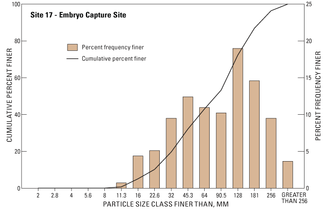
[Site: 17. Date: 08-16-2005.
Type of site: Embryo.
Location description: Ives Island, upper main channel, water’s
edge.
Substrate description: Cobble, gravel, boulder, periphyton
covered.
Vegetation description: Absent.
GPS: Lat/Long. UTM Zone 10N. WGS 84.
Waypoint: 45.62313231 -121.9881475]
| Class name | Size class (millimeter) |
No. of particles |
Percent frequency |
Cumulative percent finer |
|---|---|---|---|---|
| Fines | <2.0 | 0 | 0.00 | 0.00 |
| Very fine gravel | <2.8 | 0 | .00 | .00 |
| Very fine gravel | <4.0 | 0 | .00 | .00 |
| Fine gravel | <5.6 | 0 | .00 | .00 |
| Fine gravel | <8.0 | 0 | .00 | .00 |
| Medium gravel | <11.3 | 1 | .73 | .73 |
| Medium gravel | <16.0 | 6 | 4.38 | 5.11 |
| Coarse gravel | <22.6 | 7 | 5.11 | 10.22 |
| Coarse gravel | <32.0 | 13 | 9.49 | 19.71 |
| Very coarse gravel | <45.3 | 17 | 12.41 | 32.12 |
| Very coarse gravel | <64.0 | 15 | 10.95 | 43.07 |
| Small cobble | <90.5 | 14 | 10.22 | 53.28 |
| Small cobble | <128 | 26 | 18.98 | 72.26 |
| Large cobble | <181 | 20 | 14.60 | 86.86 |
| Large cobble | <256 | 13 | 9.49 | 96.35 |
| Boulder | ≥256 | 5 | 3.65 | 100.00 |
| Total | 137 | 100.00 |
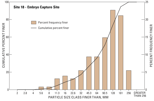
Appendix 2. Substrate data and frequency graph by site.—Continued
[Site: 18. Date: 08-16-2005.
Type of site: Embryo.
Location description: Upper Ives Island, main channel side.
Substrate description: Cobble, gravel, some boulders, dry periphyton
near pool of standing water.
Vegetation description: Absent.
GPS: Lat/Long, UTM Zone 10N, WGS 84.
Waypoint: 45.62350572 -121.9881395]
| Class name | Size class (millimeter) |
No. of particles |
Percent frequency |
Cumulative percent finer |
|---|---|---|---|---|
| Fines | <2.0 | 0 | 0.00 | 0.00 |
| Very fine gravel | <2.8 | 0 | .00 | .00 |
| Very fine gravel | <4.0 | 0 | .00 | .00 |
| Fine gravel | <5.6 | 1 | .78 | .78 |
| Fine gravel | <8.0 | 1 | .78 | 1.56 |
| Medium gravel | <11.3 | 4 | 3.13 | 4.69 |
| Medium gravel | <16.0 | 5 | 3.91 | 8.59 |
| Coarse gravel | <22.6 | 4 | 3.13 | 11.72 |
| Coarse gravel | <32.0 | 7 | 5.47 | 17.19 |
| Very coarse gravel | <45.3 | 12 | 9.38 | 26.56 |
| Very coarse gravel | <64.0 | 12 | 9.38 | 35.94 |
| Small cobble | <90.5 | 19 | 14.84 | 50.78 |
| Small cobble | <128 | 29 | 22.66 | 73.44 |
| Large cobble | <181 | 27 | 21.09 | 94.53 |
| Large cobble | <256 | 7 | 5.47 | 100.00 |
| Boulder | ≥256 | 0 | .00 | 100.00 |
| Total | 128 | 100.00 |
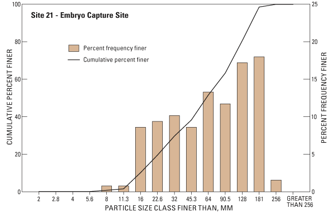
Appendix 2. Substrate data and frequency graph by site.—Continued
[Site: 21.
Date: 08-16-2005.
Type of site: Embryo.
Location description: Ives Island middle, main channel side,
0.6–0.9 meters of water.
Substrate description: Cobble, gravel, some boulder, periphyton
covered.
Vegetation sescription: Absent.
GPS: Lat/Long, UTM Zone 10N, WGS 84.
Waypoint: 45.62228238 -121.9908966]
| Class name | Size class (millimeter) |
No. of particles |
Percent frequency |
Cumulative percent finer |
|---|---|---|---|---|
| Fines | <2.0 | 0 | 0.00 | 0.00 |
| Very fine gravel | <2.8 | 0 | .00 | .00 |
| Very fine gravel | <4.0 | 0 | .00 | .00 |
| Fine gravel | <5.6 | 0 | .00 | .00 |
| Fine gravel | <8.0 | 1 | .78 | .78 |
| Medium gravel | <11.3 | 1 | .78 | 1.56 |
| Medium gravel | <16.0 | 11 | 8.59 | 10.16 |
| Coarse gravel | <22.6 | 12 | 9.38 | 19.53 |
| Coarse gravel | <32.0 | 13 | 10.16 | 29.69 |
| Very coarse gravel | <45.3 | 11 | 8.59 | 38.28 |
| Very coarse gravel | <64.0 | 17 | 13.28 | 51.56 |
| Small cobble | <90.5 | 15 | 11.72 | 63.28 |
| Small cobble | <128 | 22 | 17.19 | 80.47 |
| Large cobble | <181 | 23 | 17.97 | 98.44 |
| Large cobble | <256 | 2 | 1.56 | 100.00 |
| Boulder | ≥256 | 0 | .00 | 100.00 |
| Total | 128 | 100.00 |
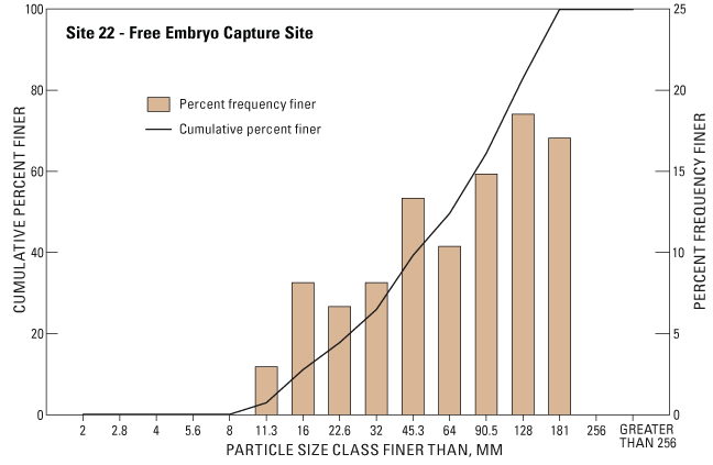
Appendix 2. Substrate data and frequency graph by site.—Continued
[Site: 22.
Date: 08-12-2005. Type of site: Free embryo.
Location description: Upper Ives Island, main channel side,
dry land site in August.
Substrate description: Cobble, gravel, dry periphyton covered.
Vegetation description: Sparse, edge of willows. GPS:
Lat/Long, UTM Zone 10N, WGS 84.
Waypoint: 45.62495504 -121.9863766]
| Class name | Size class (millimeter) |
No. of particles |
Percent frequency |
Cumulative percent finer |
|---|---|---|---|---|
| Fines | <2.0 | 0 | 0.00 | 0.00 |
| Very fine gravel | <2.8 | 0 | .00 | .00 |
| Very fine gravel | <4.0 | 0 | .00 | .00 |
| Fine gravel | <5.6 | 0 | .00 | .00 |
| Fine gravel | <8.0 | 0 | .00 | .00 |
| Medium gravel | <11.3 | 4 | 2.96 | 2.96 |
| Medium gravel | <16.0 | 11 | 8.15 | 11.11 |
| Coarse gravel | <22.6 | 9 | 6.67 | 17.78 |
| Coarse gravel | <32.0 | 11 | 8.15 | 25.93 |
| Very coarse gravel | <45.3 | 18 | 13.33 | 39.26 |
| Very coarse gravel | <64.0 | 14 | 10.37 | 49.63 |
| Small cobble | <90.5 | 20 | 14.81 | 64.44 |
| Small cobble | <128 | 25 | 18.52 | 82.96 |
| Large cobble | <181 | 23 | 17.04 | 100.00 |
| Large cobble | <256 | 0 | .00 | 100.00 |
| Boulder | ≥256 | 0 | .00 | 100.00 |
| Total | 135 | 100.00 |
Appendix 2. Substrate data and frequency graph by site.—Continued
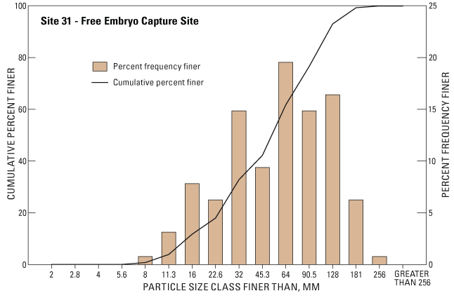
[Site: 31.
Date: 08-12-2005. Type of site: Free embryo.
Location description: Upper Ives Island, main channel side,
dry land site in August.
Substrate description: Cobble, gravel, dry periphyton covered.
Vegetation description: Moderate coverage, willows.
GPS: Lat/Long, UTM Zone 10N, WGS 84.
Waypoint: 45.62489829 -121.9864324]
| Class name | Size class (millimeter) |
No. of particles |
Percent frequency |
Cumulative percent finer |
|---|---|---|---|---|
| Fines | <2.0 | 0 | 0.00 | 0.00 |
| Very fine gravel | <2.8 | 0 | .00 | .00 |
| Very fine gravel | <4.0 | 0 | .00 | .00 |
| Fine gravel | <5.6 | 0 | .00 | .00 |
| Fine gravel | <8.0 | 1 | .78 | .78 |
| Medium gravel | <11.3 | 4 | 3.13 | 3.91 |
| Medium gravel | <16.0 | 10 | 7.81 | 11.72 |
| Coarse gravel | <22.6 | 8 | 6.25 | 17.97 |
| Coarse gravel | <32.0 | 19 | 14.84 | 32.81 |
| Very coarse gravel | <45.3 | 12 | 9.38 | 42.19 |
| Very coarse gravel | <64.0 | 25 | 19.53 | 61.72 |
| Small cobble | <90.5 | 19 | 14.84 | 76.56 |
| Small cobble | <128 | 21 | 16.41 | 92.97 |
| Large cobble | <181 | 8 | 6.25 | 99.22 |
| Large cobble | <256 | 1 | .78 | 100.00 |
| Boulder | ≥256 | 0 | .00 | 100.00 |
| Total | 128 | 100.00 |
Appendix 2. Substrate data and frequency graph by site.—Continued
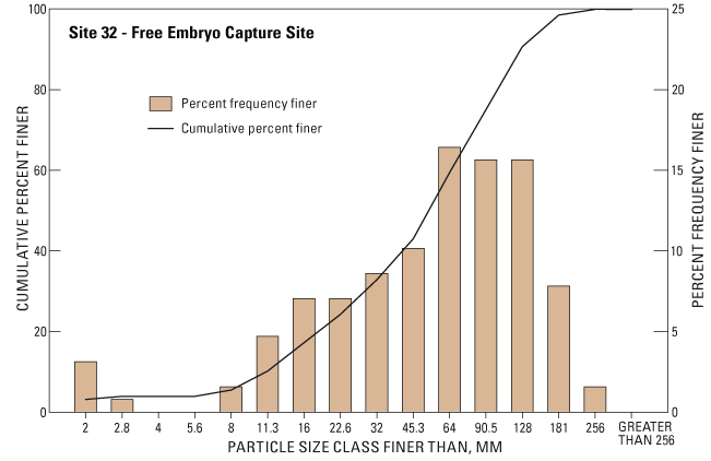
[Site: 32.
Date: 08-12-2005.
Type of site: Free embryo.
Location description: Upper Ives Island, main channel side,
dry land site in August.
Substrate description: Cobble, gravel, dry periphyton covered.
Vegetation description: Heavy coverage, willows.
GPS: Lat/Long, UTM Zone 10N, WGS 84.
Waypoint: 45.62493341 -121.9865616]
| Class name | Size class (millimeter) |
No. of particles |
Percent frequency |
Cumulative percent finer |
|---|---|---|---|---|
| Fines | <2.0 | 4 | 3.13 | 3.13 |
| Very fine gravel | <2.8 | 1 | .78 | 3.91 |
| Very fine gravel | <4.0 | 0 | .00 | 3.91 |
| Fine gravel | <5.6 | 0 | .00 | 3.91 |
| Fine gravel | <8.0 | 2 | 1.56 | 5.47 |
| Medium gravel | <11.3 | 6 | 4.69 | 10.16 |
| Medium gravel | <16.0 | 9 | 7.03 | 17.19 |
| Coarse gravel | <22.6 | 9 | 7.03 | 24.22 |
| Coarse gravel | <32.0 | 11 | 8.59 | 32.81 |
| Very coarse gravel | <45.3 | 13 | 10.16 | 42.97 |
| Very coarse gravel | <64.0 | 21 | 16.41 | 59.38 |
| Small cobble | <90.5 | 20 | 15.63 | 75.00 |
| Small cobble | <128 | 20 | 15.63 | 90.63 |
| Large cobble | <181 | 10 | 7.81 | 98.44 |
| Large cobble | <256 | 2 | 1.56 | 100.00 |
| Boulder | ≥256 | 0 | .00 | 100.00 |
| Total | 128 | 100.00 |
Appendix 2. Substrate data and frequency graph by site.—Continued
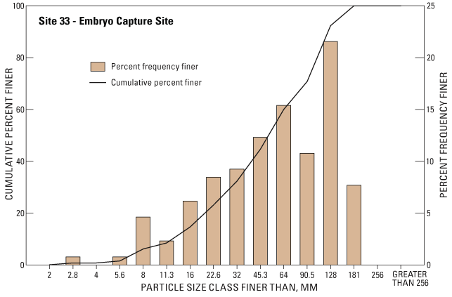
[Site: 33.
Date: 08-12-2005.
Type of site: Embryo.
Location description: Upper Ives Island, shallow water at eastern
tip island, start of side channel.
Substrate description: Cobble, gravel, periphyton covered.
Vegetation description: Absent.
GPS: Lat/Long, UTM Zone 10N, WGS 84.
Waypoint: 45.62611006 -121.9854349]
| Class name | Size class (millimeter) |
No. of particles |
Percent frequency |
Cumulative percent finer |
|---|---|---|---|---|
| Fines | <2.0 | 0 | 0.00 | 0.00 |
| Very fine gravel | <2.8 | 1 | .77 | .77 |
| Very fine gravel | <4.0 | 0 | .00 | .77 |
| Fine gravel | <5.6 | 1 | .77 | 1.54 |
| Fine gravel | <8.0 | 6 | 4.62 | 6.15 |
| Medium gravel | <11.3 | 3 | 2.31 | 8.46 |
| Medium gravel | <16.0 | 8 | 6.15 | 14.62 |
| Coarse gravel | <22.6 | 11 | 8.46 | 23.08 |
| Coarse gravel | <32.0 | 12 | 9.23 | 32.31 |
| Very coarse gravel | <45.3 | 16 | 12.31 | 44.62 |
| Very coarse gravel | <64.0 | 20 | 15.38 | 60.00 |
| Small cobble | <90.5 | 14 | 10.77 | 70.77 |
| Small cobble | <128 | 28 | 21.54 | 92.31 |
| Large cobble | <181 | 10 | 7.69 | 100.00 |
| Large cobble | <256 | 0 | .00 | 100.00 |
| Boulder | ≥256 | 0 | .00 | 100.00 |
| Total | 130 | 100.00 |
Appendix 2. Substrate data and frequency graph by site.—Continued
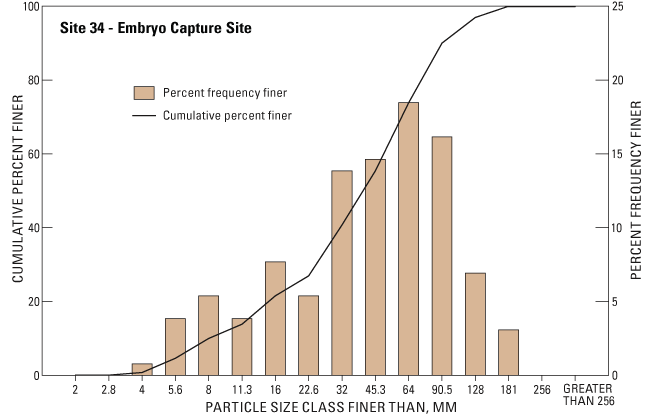
[Site: 34.
Date: 08-16-2005.
Type of site: Embryo.
Location description: Upper Ives Island, shallow water at eastern
tip island, start of side channel.
Substrate description: Cobble, gravel, periphyton covered.
Vegetation description: Absent.
GPS: Lat/Long, UTM Zone 10N, WGS 84.
Waypoint: 45.62628692 -121.9849599]
| Class name | Size class (millimeter) |
No. of particles |
Percent frequency |
Cumulative percent finer |
|---|---|---|---|---|
| Fines | <2.0 | 0 | 0.00 | 0.00 |
| Very fine gravel | <2.8 | 0 | .00 | .00 |
| Very fine gravel | <4.0 | 1 | .77 | .77 |
| Fine gravel | <5.6 | 5 | 3.85 | 4.62 |
| Fine gravel | <8.0 | 7 | 5.38 | 10.00 |
| Medium gravel | <11.3 | 5 | 3.85 | 13.85 |
| Medium gravel | <16.0 | 10 | 7.69 | 21.54 |
| Coarse gravel | <22.6 | 7 | 5.38 | 26.92 |
| Coarse gravel | <32.0 | 18 | 13.85 | 40.77 |
| Very coarse gravel | <45.3 | 19 | 14.62 | 55.38 |
| Very coarse gravel | <64.0 | 24 | 18.46 | 73.85 |
| Small cobble | <90.5 | 21 | 16.15 | 90.00 |
| Small cobble | <128 | 9 | 6.92 | 96.92 |
| Large cobble | <181 | 4 | 3.08 | 100.00 |
| Large cobble | <256 | 0 | .00 | 100.00 |
| Boulder | ≥256 | 0 | .00 | 100.00 |
| Total | 130 | 100.00 |
Appendix 2. Substrate data and frequency graph by site.—Continued
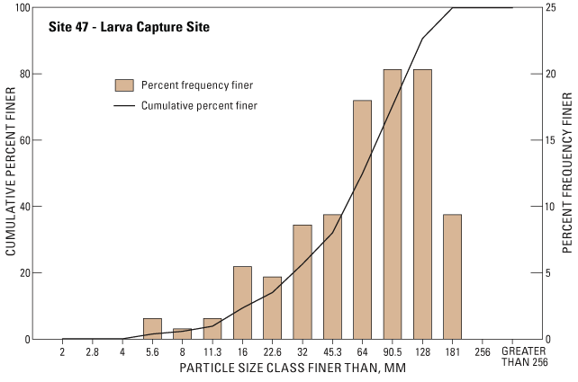
[Site: 47.
Date: 08-16-2005.
Type of site: Larva.
Location description: Ives Island, middle, main channel side.
Substrate description: Cobble, gravel, dry periphyton covered.
Vegetation description: Sparse.
GPS: Lat/Long, UTM Zone 10N, WGS 84.
Waypoint: 45.62309953 -121.9894973]
| Class name | Size class (millimeter) |
No. of particles |
Percent frequency |
Cumulative percent finer |
|---|---|---|---|---|
| Fines | <2.0 | 0 | 0.00 | 0.00 |
| Very fine gravel | <2.8 | 0 | .00 | .00 |
| Very fine gravel | <4.0 | 0 | .00 | .00 |
| Fine gravel | <5.6 | 2 | 1.56 | 1.56 |
| Fine gravel | <8.0 | 1 | .78 | 2.34 |
| Medium gravel | <11.3 | 2 | 1.56 | 3.91 |
| Medium gravel | <16.0 | 7 | 5.47 | 9.38 |
| Coarse gravel | <22.6 | 6 | 4.69 | 14.06 |
| Coarse gravel | <32.0 | 11 | 8.59 | 22.66 |
| Very coarse gravel | <45.3 | 12 | 9.38 | 32.03 |
| Very coarse gravel | <64.0 | 23 | 17.97 | 50.00 |
| Small cobble | <90.5 | 26 | 20.31 | 70.31 |
| Small cobble | <128 | 26 | 20.31 | 90.63 |
| Large cobble | <181 | 12 | 9.38 | 100.00 |
| Large cobble | <256 | 0 | .00 | 100.00 |
| Boulder | ≥256 | 0 | .00 | 100.00 |
| Total | 128 | 100.00 |

![]() U.S.
Department of the Interior | U.S. Geological
Survey
U.S.
Department of the Interior | U.S. Geological
Survey
Persistent URL: https://pubs.water.usgs.gov/sir20065225
Page Contact Information: Publications Team
Page Last Modified: Thursday, 01-Dec-2016 19:26:47 EST
