

|
|
Coastal and Marine Geology Program
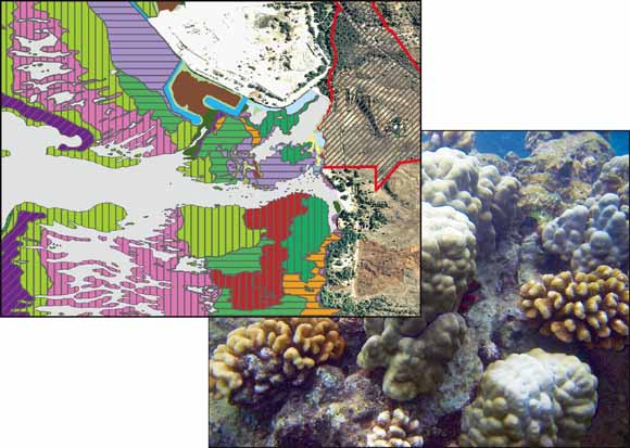
Left, enlarged portion of benthic habitat map showing Pelekane Bay and Pu‘ukoholā Heiau National Historic Site shoreline. Right, underwater photograph shows example of coral reef habitat on the Kona coast of Hawai‘i.
In cooperation with the U.S. National Park Service (NPS), the U.S. Geological Survey (USGS) has mapped the underwater environment in and adjacent to three parks along the Kona coast on the island of Hawai‘i. This report is the second of two produced for the NPS on the geologic resource evaluation of Pu‘ukoholā Heiau National Historic Site (PUHE) and presents benthic habitat mapping of the waters of Kawaihae Bay offshore of PUHE. See Part I (Richmond and others, 2006) for an overview of the regional geology, local volcanics, and a detailed description of coastal landforms in the park.
PUHE boundaries do not officially extend into the marine environment; however, impacts downslope of any activity in the park are of concern to management. The area of Kawaihae Bay mapped for this report extends from the north edge of the U.S. Coast Guard Reservation north of Kawaihae Harbor approximately 3.5 km south to the north edge of the Mauna Kea Golf Course and Beach Resort at Waikoloa and from the shoreline to depths of approximately 40 m (130 ft), where the fore reef drops off to the sandy shelf. The waters of smaller Pelekane Bay directly offshore of the park, while not formally under NPS jurisdiction, are managed by the park under an agreement with the State. This embayment is described in greater detail because of its special resource status.
PUHE lies within the Kawaihae watershed, which contributes ~75 percent of the drainage in the northern portion of the study area; the Waikoloa/Waiulaula watershed contributes ~25 percent in the southern portion of the study area. Drainages from these watersheds into the study area include Makahuna, Makeāhua, Pohaukole, Kukui, and Waikoloa/Waiulaula Gulches. The Waikoloa/Waiulaula Gulch is the only perennial stream with a year-round water flow. Only during periods of extreme rainfall will water flow in the Makeāhua and Pohaukole gulches, merge together in the park, and empty directly into Pelekane Bay.
In the late 1950s the reef off of PUHE was dredged to construct Kawaihae Harbor. Coral rubble was used in the construction of causeways and a revetment wall surrounding the commercial harbor. In the late 1960s the reef near Pelekane was blasted to create a small-boat harbor adjacent to the larger commercial harbor. Damage from these activities, in addition to a change in circulation patterns, has led to problems of high turbidity in Pelekane Bay.
Download this report as a 25-page PDF file (sir2006-5254.pdf; 7.7 MB).
Read the metadata for the GIS data linked below. (PUHE_BenthicHabitats_meta.htm; 40 kB).
Download the GIS data for this report as a compressed file. This file includes the shapefile and associated metadata files for the benthic habitat map (PUHE_bhabs.zip; 312 kB).
USGS Open-File Report 2008-1190, Geologic Resource Evaluation of Pu‘ukoholā Heiau National Historic Site, Hawai‘i; Part I: Geology and Coastal Landforms by Bruce M. Richmond, Susan A. Cochran, and Ann E. Gibbs
For questions about the content of this report, contact Susan Cochran
Download a copy of the latest version of Adobe Reader for free.
|
Help |
PDF help |
Publications main page |
| Western Scientific Investigations Reports |
| Geography | Coastal and Marine Geology
|

![]() U.S. Department of the Interior | U.S. Geological Survey
U.S. Department of the Interior | U.S. Geological Survey
URL: https://pubs.usgs.gov/sir/2006/5254/
Page Contact Information: Michael Diggles
Page Created: March 15, 2007
Page Last Modified: February 18, 2009