Scientific Investigations Report 2006-5273
In cooperation with the City of Delafield
This report is available for download as a PDF (3,895 KB)
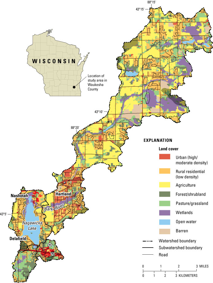
Figure 1. Maps showing watershed of Nagawicka Lake at Delafield, Wis.
Figure 2. Maps showing subbasins and land use/land cover of the near-lake drainage area of Nagawicka Lake.
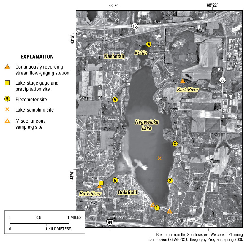
Figure 3. Maps showing locations and types of data-collection sites at Nagawicka Lake.
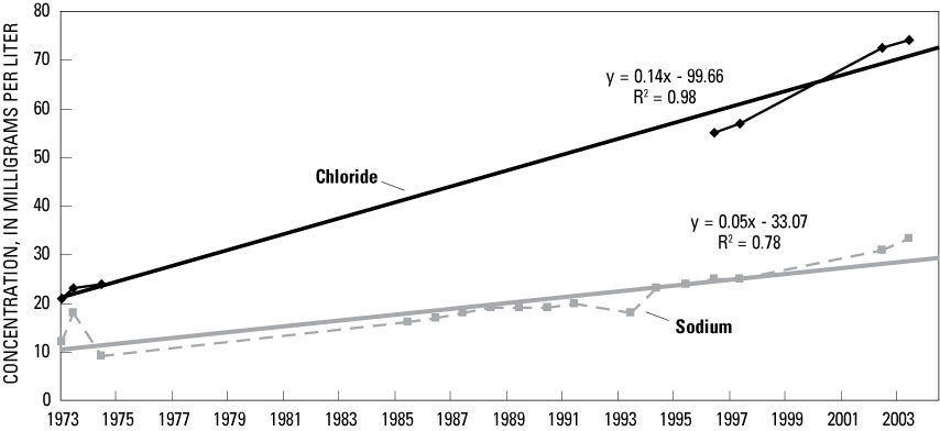
Figure 4. Graphs showing trends in sodium and chloride concentrations in Nagawicka Lake, 1972–2004.
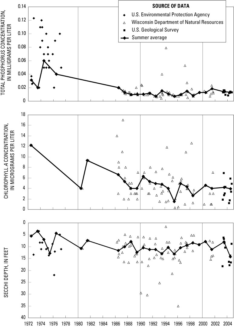
Figure 5. Graphs showing measured Secchi depths, and total phosphorus and chlorophyll a concentrations, and summer average values at the deep hole in Nagawicka Lake, 1972–2004.
Figure 6. Graphs showing relation between summer average total phosphorus concentration and summer average A, chlorophyll a concentration and B, Secchi depth transparency in Nagawicka Lake.
Figure 7. Graphs showing trophic state index values based on surface concentrations of total phosphorus and chlorophyll a, and Secchi depths, Nagawicka Lake, 1972–2004.
Figure 8. Graphs showing estimated changes in summer total phosphorus concentrations based on changes in the diatom community in the sediments cores from Nagawicka Lake.
Figure 9. Graphs showing daily water levels of Nagawicka Lake and daily average streamflow in the Bark River at the inlet and outlet stream gages of Nagawicka Lake, November 2002–October 2004.
Figure 10. Graphs showing precipitation at Nagawicka Lake, during November 2002–October 2004, relative to long-term average precipitation.
Figure 11. Photograph showing stream gage at the outlet of subwatershed 2 at Delafield, Wis., with water-level logger and siphon sampler.
Figure 12. Photograph showing Nagawicka Lake Dam at Delafield.
Figure 13. Graph showing ground-water levels in piezometers in relation to lake stage, 2003 and 2004, at Nagawicka Lake.
Figure 14. Pie charts showing water budget for Nagawicka Lake, for monitoring years 2003 and 2004.
Figure 15. Graphs showing monthly total water inputs and outputs plus storage change for Nagawicka Lake, November 2002–October 2004.
Figure 16. Graphs showing daily average streamflow, and loads of total phosphorus and suspended sediment at the Bark River inlet to Nagawicka Lake, November 2002–October 2004.
Figure 17. Graphs showing daily average streamflow, and loads of total phosphorus and suspended sediment at the Bark River outlet from Nagawicka Lake, November 2002–October 2004.
Figure 18. Pie charts showing phosphorus budgets for Nagawicka Lake, for monitoring years 2003 and 2004.
Figure 19. Graphs showing simulated changes in concentrations of near-surface total phosphorus in Nagawicka Lake with WiLMS in response to various phosphorus-loading scenarios.
Figure 20. Graphs showing simulated changes in concentrations of near-surface chlorophyll a and Secchi depth in Nagawicka Lake in response to various phosphorus-loading scenarios.
Table 1. Land use/land cover in the Nagawicka Lake watershed from classifications defined by the Southeastern Wisconsin Planning Commission and WISCLAND.
Table 2. Average near-surface summer water quality and trophic state index values for Nagawicka Lake, Wis.
Table 3. Summary of water-budget components for Nagawicka Lake, monitoring years 2003–04.
Table 4. Summary of phosphorus-budget components for Nagawicka Lake monitoring years 2003–04.
Table 5. Concentrations of dissolved phosphorus in ground water from piezometers at Nagawicka Lake.
Table 6. Allocation of phosphorus loading to land-use/land-cover categories in the Nagawicka Lake watershed.
Table 7. Annual phosphorus loading associated with various scenarios simulated with the models within the Wisconsin Lakes Modeling Suite.
Table 8. Estimated water quality in Nagawicka Lake in response to the average annual phosphorus loading in MY 2003−04 and 1970s based on the models within the Wisconsin Lakes Modeling Suite.
Table 9. Predicted near-surface, average summer chlorophyll a concentrations and Secchi depths in Nagawicka Lake, for various scenarios.
Multiply |
By |
To Obtain |
Length |
||
| inch (in.) | centimeter (cm) | |
| foot (ft) | meter (m) | |
| mile (mi) | kilometer (km) | |
Area |
||
| acre | square meter (m2) | |
| square mile (mi2) | square kilometer (km2) | |
Volume |
||
| acre-foot (acre-ft) | cubic meter (m3) | |
Flow rate |
||
| cubic foot per second (ft3/s) | cubic meter per second (m3/s) | |
| pound, avoirdupois (lb) | kilogram (kg) | |
| ton, short (2,000 lb) | kilogram (kg) | |
| pounds per square mile (lb/mi2) | kilograms per square kilometer [(kg/km2)/yr] | |
Temperature in degrees Celsius (°C) may be converted to degrees Fahrenheit (°F) as follows: °F=(1.8×°C)+32 Altitude, as used in this report, refers to distance above the vertical datum. Specific conductance is given in microsiemens per centimeter at 25 degrees Celsius (µS/cm at 25°C). Concentrations of chemical constituents in water are given either in milligrams per liter (mg/L) or micrograms per liter (µg/L). Sedimentation rates are given in grams per square centimeter (g/cm2). |
||
David A. Saad, Hydrologist, U.S. Geological Survey, Middleton, Wis.
Jeffrey A. Thornton, Principal Planner, Southeastern Wisconsin
Regional Planning Commission, Waukesha, Wis.
Phil Schuman, City of Delafield, Lake Welfare Committee, Delafield, Wis.
C. Michael Eberle, Technical Editor, U.S. Geological Survey, Columbus, Ohio.
Michelle M. Greenwood, Geographer, U.S. Geological Survey, Middleton, Wis.
Jennifer L. Bruce, Geographer, U.S. Geological Survey, Middleton, Wis.
James L. Kennedy, Geographer, U.S. Geological Survey, Middleton, Wis.
Chad J. Bloom, Student Trainee (Hydrology), U.S. Geological Survey, Middleton,
Wis.
Gerald L. Goddard, Hydrologic Technician, U.S. Geological Survey, Middleton,
Wis.
Chad J. Bloom, Student Trainee (Hydrology), U.S. Geological Survey, Middleton,
Wis.
Nagawicka Lake is a 986-acre, usually mesotrophic, calcareous lake in southeastern Wisconsin. Because of concern over potential water-quality degradation of the lake associated with further development in its watershed, a study was conducted by the U.S. Geological Survey from 2002 to 2006 to describe the water quality and hydrology of the lake; quantify sources of phosphorus, including those associated with urban development; and determine the effects of past and future changes in phosphorus loading on the water quality of the lake. All major water and phosphorus sources were measured directly, and minor sources were estimated to construct detailed water and phosphorus budgets for the lake. The Bark River, near-lake surface inflow, precipitation, and ground water contributed 74, 8, 12, and 6 percent of the inflow, respectively. Water leaves the lake primarily through the Bark River outlet (88 percent) or by evaporation (11 percent). The water quality of Nagawicka Lake has improved dramatically since 1980 as a result of decreasing the historical loading of phosphorus to the lake. Total input of phosphorus to the lake was about 3,000 pounds in monitoring year (MY) 2003 and 6,700 pounds in MY 2004. The largest source of phosphorus entering the lake was the Bark River, which delivered about 56 percent of the total phosphorus input, compared with about 74 percent of the total water input. The next largest contributions were from the urbanized near-lake drainage area, which disproportionately accounted for 37 percent of the total phosphorus input but only about 5 percent of the total water input.
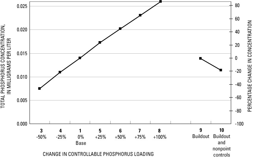
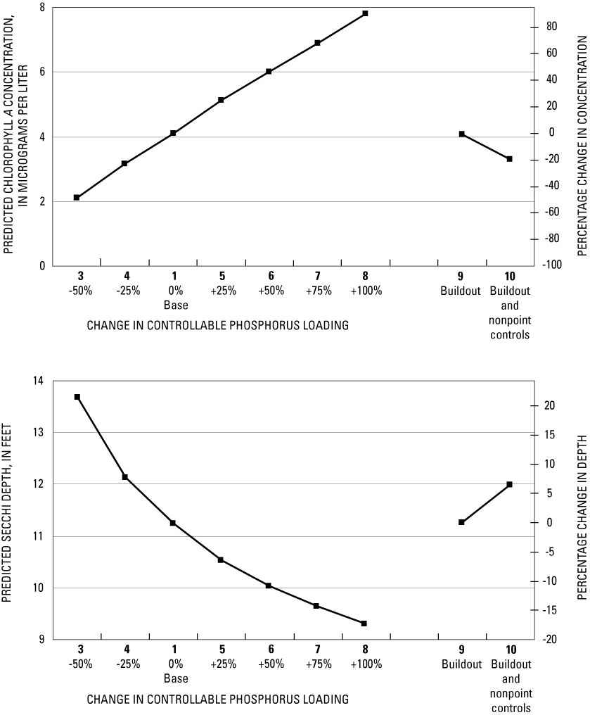
Simulations with water-quality models within the Wisconsin Lakes Modeling Suite (WiLMS) indicated the response of Nagawicka Lake to 10 phosphorus-loading scenarios. These scenarios included historical (1970s) and current (base) years (MY 2003–04) for which lake water quality and loading were known, six scenarios with percentage increases or decreases in phosphorus loading from controllable sources relative to the base years 2003–04, and two scenarios corresponding to specific management actions. Because of the lake’s calcareous character, the average simulated summer concentration of total phosphorus for Nagawicka Lake was about 2 times that measured in the lake. The models likely over-predict because they do not account for coprecipitation of phosphorus and dissolved organic matter with calcite, negligible release of phosphorus from the deep sediments, and external phosphorus loading with abnormally high amounts of nonavailable phosphorus. After adjusting the simulated results for the overestimation of the models, a 50-percent reduction in phosphorus loading resulted in an average predicted phosphorus concentration of 0.008 milligrams per liter (mg/L) (a decrease of 46 percent). With a 50-percent increase in phosphorus loading, the average predicted concentration was 0.020 mg/L (an increase of 45 percent). With the changes in land use under the assumed future full development conditions, the average summer total phosphorus concentration should remain similar to that measured in MY 2003–04 (approximately 0.014 mg/L). However, if stormwater and nonpoint controls are added to achieve a 50-percent reduction in loading from the urbanized near-lake drainage area, the average summer total phosphorus concentration should decrease from the present conditions (MY 2003–04) to 0.011 mg/L. Slightly more than a 25‑percent reduction in phosphorus loading from that measured in MY 2003–04 would be required for the lake to be classified as oligotrophic.
Nagawicka Lake is among a concentration of lakes in the Kettle Moraines Level IV Ecoregion within the Southeastern Wisconsin Till Plains (Omernik and others, 2000). The lake, which is about 7 mi northwest of Waukesha and 25 mi west of the metropolitan area of Milwaukee, is an important recreational water resource in northwestern Waukesha County, Wisconsin (fig. 1). The lake is the main natural feature of the City of Delafield, which encompasses most of its shore. The Bark River is the main tributary to the lake.
Figure 1. Watershed of Nagawicka Lake at Delafield, Wis. Land use/land cover from the Southeastern Wisconsin Regional Planning Commission for 2000 (J. A. Thornton, Southeastern Wisconsin Regional Planning Commission, written commun., 2005). Shaded areas represent land-use/land-cover classifications that were not available and were obtained from the WISCLAND geographic information coverage (Lillesand and others, 1998).
As a result of receiving runoff of nutrients and other pollutants from agricultural fields, gravel operations, and industrial areas, as well as effluent from the Hartland Sewage Treatment Plant, the water quality of Nagawicka Lake was at one time severely degraded. By 1970, the lake had extensive macrophyte beds, filamentous algal growth, and blue-green algal blooms (Nagawicka Lake Improvement Association, 1971). In an effort to improve the water quality of Nagawicka Lake and other southeastern Wisconsin lakes, the Southeastern Wisconsin Regional Planning Commission (SEWRPC) developed a regional water-quality-management plan in 1979 (Southeastern Wisconsin Regional Planning Commission, 1979). This plan recognized that excessive phosphorus loading was the major cause of the water-quality degradation and excessive plant growth. As part of this plan, a phosphorus budget was developed for the lake. In the 1970s, it was estimated that about 11,300 lb/yr of phosphorus was input to the lake: approximately 4,300 lb/yr (about 38 percent) came from Hartland Sewage Treatment Plant effluent discharged into the Bark River upstream from Nagawicka Road (fig. 2), and about 3,600 lb/yr (about 32 percent) was contributed from confined livestock operations in the near-lake drainage area. The near-lake drainage area contributed about 5,600 lb/yr of phosphorus to Nagawicka Lake.
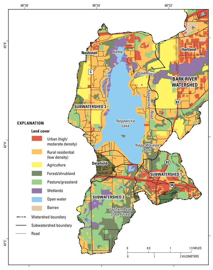
Figure 2. Subbasins and land use/land cover of the near-lake drainage area of Nagawicka Lake at Delafield, Wis. Land use/land cover from the Southeastern Wisconsin Regional Planning Commission for 2000 (J. A. Thornton, Southeastern Wisconsin Regional Planning Commission, written commun., 2005). Shaded areas represent land-use/land-cover classifications that were not available and were obtained from the WISCLAND geographic information coverage (Lillesand and others, 1998).
As a result of the 1979 plan, a sanitary sewerage system was constructed to serve the residences and urban areas in the drainage area directly surrounding the lake. Effective in 1980, discharge of treated effluent was diverted to the Bark River downstream from Nagawicka, Lake (Matt Carlson, City of Delafield, written commun., 2006). The new system is operated by the City of Delafield and the Villages of Nashotah and Hartland, and is connected to the Dela-Hart Water Pollution Control Commission Treatment Plant in Delafield downstream from the outlet of Nagawicka Lake and outside the watershed shown in figure 1. The regional plan called for virtually all of the upstream area of Delafield to Hartland to be served by the sanitary sewer system by 2010 (Southeastern Wisconsin Regional Planning Commission, 1999). Most of the confined livestock operations in the immediate drainage area surrounding the lake were discontinued between 1982 and 1985, leaving only one or two operating after 2000. Therefore, approximately 70 percent of the phosphorus loading to Nagawicka Lake in the 1970s had been removed by 1985; however, additional urban sources of phosphorus have been added by new development.
In 1987, a Lake Welfare Committee was formed by the Delafield City Council to conduct studies and undertake lake-management activities for Nagawicka Lake and the City of Delafield. This Committee has subsequently implemented a program of study that has included watershed, water-quality, and lake-management-planning investigations. The Committee has encouraged the Village of Nashotah, also situated on the lake and the Village of Hartland, upstream from the lake in the Bark River watershed (fig. 1), to participate in their proceedings. The City of Delafield has promoted and implemented several measures to improve and protect the water quality of the lake, including measures for land-use control and management, control of nonpoint-source pollution on urban lands in the watershed, and preparation of stormwater-management plans. SEWRPC has provided planning assistance to the City of Delafield by preparing an updated Lake and Watershed Inventory (Southeastern Wisconsin Regional Planning Commission, 1999) and developing a Lake-Management Plan specific to Nagawicka Lake (Southeastern Wisconsin Regional Planning Commission, 2001).
Two principal issues identified in the 2001 Lake-Management Plan were (1) potential changes in the water quality of Nagawicka Lake associated with human activities and development in the watershed and (2) operation of lake-outlet structures to maintain water levels and reduce flooding. The lake is a popular destination for recreational users and is heavily used. As a result, various problems have arisen during recent years, including surface-use conflicts, siltation, abundant growth of aquatic plants in shallow areas, shoreline modification, and concerns about reduced water quality caused by residential and commercial growth. Land within the rapidly developing area encompassing the Interstate 94 and State Highway 83 intersection southeast of the lake (fig. 2) was particularly identified as a critical area for nonpoint-source pollution in the Lake-Management Plan (Southeastern Wisconsin Regional Planning Commission, 2001).
Very little information was available on the inflow quantity, water quality, and phosphorus loadings from the Bark River and other sources when the 1999 Lake and Watershed Inventory and 2001 Lake-Management Plan were completed—most of the estimates were based on model simulations. The Lake- and Stormwater-Management Plans recommended specific actions in the Nagawicka Lake watershed to reduce phosphorus loadings from urban, commercial, and residential sources. In addition, the plans recommended that specific information be acquired on the hydrology of Nagawicka Lake so as to better address the management of the lake. This information is important to accurately quantify the response of the lake to changes in external influences.
Continuing issues of concern to lake-area residents are the effects of expanding residential and commercial development in the Nagawicka lake watershed, the effects of expanding recreational use of the lake, and the effects of these changes on the water quality of the lake. Because of continuing concern over perceived degradation of water quality and the need for an updated management plan for the lake, the U.S. Geological Survey (USGS), in cooperation with the City of Delafield, did a study with the following objectives:
In support of this study, the Wisconsin Department of Natural Resources (WDNR) provided funding assistance to the City of Delafield through the Lake Protection Grant Program (Grant LPT-201).
Nagawicka Lake (fig. 3) is a natural lake consisting of a large, deep south basin and a small shallower north basin (referred to as “the kettle”) connected by a short canal. The lake was formed about 10,000 years ago as the Michigan and Green Bay lobes of the continental glacier retreated during the Wisconsin glaciation. It is a drainage lake situated near the center of the Bark River watershed; the Bark River is the lake’s single inlet and outlet. Nagawicka Lake is the uppermost of a chain of lakes that include Upper and Lower Nemahbin and Crooked Lakes. The City of Delafield is on Nagawicka Lake’s southern shore and the Village of Nashotah is on its northwestern shore (fig. 1). The lake and its watershed characteristics were described in detail by Southeastern Wisconsin Regional Planning Commission (1999).
Figure 3. Locations and types of data-collection sites at Nagawicka Lake, Wis.
The lake level is controlled by a dam at the lake outlet by means of radial gates and lift gates for a mill race on the outlet structures. The dam, constructed in 1937 (Matt Carlson, written commun., 2006), raised the lake’s water surface by about 7 ft (Wisconsin Department of Natural Resources, 2005). The inclusion or exclusion of the kettle on the north end of the lake and different accounting of the artificial channels in wetlands on the western shoreline have resulted in different surface areas being published for the lake. The 1966 Wisconsin Conservation Department lake survey map listed the lake area as 1,026 acres, shoreline length as 7.6 mi, and volume as about 33,400 acre-ft. Waukesha County and Southeastern Wisconsin Regional Planning Commission (1999) report the lake area as 957 acres, shoreline length as 8.6 mi, and volume as 45,900 acre-ft on the basis of more recent measurements. The Wisconsin Department of Natural Resources (WDNR) report the lake surface area as 917 acres, maximum depth as 90 ft, and average depth as 36 ft (Wisconsin Department of Natural Resources, 2001). The values from the WDNR are the ones used for regulatory purposes. This study delineated a lake surface area of 986 acres (including the kettle and part of the wetlands on the western shore, based on USGS quadrangle maps), shoreline length of 9.5 mi, maximum depth of 90 ft, and total volume of 25,400 acre‑ft (based on detailed morphometry from Mapping Specialists, Ltd., 2002); these were the values used for computations in this report. The kettle has a maximum depth of 42 ft.
The major tributary to Nagawicka Lake is the Bark River, which flows into the lake on the northeast side (figs. 1 and 2). The area of the watershed upstream from the outlet (dam) of the lake is 44.9 mi2. In addition to the upstream Bark River watershed, the direct drainage area surrounding the lake, including the City of Delafield and Village of Nashotah, is about 9 mi2. Outflow from the lake is into the Bark River, a tributary of the Rock River, which eventually drains into Illinois and into the Mississippi River.
Land use in the Nagawicka Lake watershed is a mixture of agriculture (cropland), urban (commercial and high- and medium-density residential), rural residential, pasture, forest, and wetland. In 2000, about 36 percent of the total watershed was in agricultural and pasture land uses (table 1 and fig. 1). Urban/residential land uses comprised about 35 percent of the total watershed, and about 50 percent of the near-lake direct-drainage area. All but about one-third of the shoreline of Nagawicka Lake is developed—two-thirds of the total shoreline has been developed for residential use. Most of the undeveloped area surrounds the kettle or is in Naga-Waukee County Park on the southeastern shore of the lake. An area of natural shoreline in public ownership is preserved in Naga-Waukee County Park, and the drainage south of Interstate 94 contains part of the Lapham Peak Unit of the Kettle Moraine State Forest. The land-use/land-cover data (as of 2000; Southeastern Wisconsin Regional Planning Commission, written commun., 2005) are summarized in table 1 for the upstream Bark River watershed, the near-lake drainage area, the entire watershed and the three subwatersheds constituting the near-lake drainage area.
Table 1. Land use/land cover in the Nagawicka Lake watershed from classifications defined by the Southeastern Wisconsin Regional Planning Commission (SEWRPC) and WISCLAND (Lillesand and others, 1998) in figure 1.
(station 05426067) |
(subwatersheds 1, 2, and 3) |
(station 05426070) |
||||||
(acres) |
watershed |
(acres) |
watershed |
(acres) |
watershed |
|||
| Urban, high and moderate density | ||||||||
| Rural residential | ||||||||
| Agriculture (cropland) | ||||||||
| Pasture/grassland | ||||||||
| Forest/shrubland | ||||||||
| Barren land | ||||||||
| Wetland | ||||||||
| Open water | ||||||||
| Total | ||||||||
(ungaged area) |
||||||||
(acres) |
watershed |
(acres) |
watershed |
(acres) |
watershed |
|||
| Urban high and moderate density | ||||||||
| Rural residential | ||||||||
| Agriculture | ||||||||
| Pasture/grassland | ||||||||
| Forest/shrubland | ||||||||
| Barren land | ||||||||
| Wetland | ||||||||
| Open water | ||||||||
| Total | ||||||||
Nagawicka Lake, like some lakes in southeastern Wisconsin, is a hardwater, calcareous lake with relatively high alkalinity and high calcium and magnesium concentrations reflecting the limestone and dolomite bedrock in the area (Lillie and Mason, 1983). Calcareous lakes have high concentrations of dissolved calcium carbonate and commonly experience marling or deposition of calcium carbonate (also referred to as calcite) in the sediments of the lake. Calcareous lakes commonly have lower total phosphorus concentrations during summer than noncalcareous lakes with similar phosphorus loading because phosphorus loading from watersheds with these soils may have abnormally high amounts of phosphorus that are tightly bound to eroded sediment (as apatite) and not available for biological productivity (Stauffer, 1985). In addition, the naturally sustained inputs of carbonates and other cations can cause the loss or removal of phosphorus from the lake water by coprecipitation with (adsorption on) calcite (Murphy and others, 1983; Kleiner, 1988; Jager and Rohrs, 1990). Environmental conditions that favor increased calcite (and phosphorus) precipitation are an increase in pH (often associated with photosynthesis by aquatic plants) and an increase in temperature (Stumm and Morgan, 1996). The loss of phosphorus with the coprecipitation with calcite can be substantial, with as much as 25 and 45 percent of the total phosphorus being removed from the epilimnion (Grobbelaar and House, 1995). It also has been suggested that release of phosphorus from the deep sediment (also referred to as internal loading of phosphorus) of eutrophic hard-water lakes is reduced or eliminated even during anoxic periods because the phosphorus that is tightly bound with the calcite is not affected by changing redox conditions (Jager and Rohrs, 1990). Therefore, phosphorus in the deep sediments of calcareous lakes may be effectively trapped. Stauffer (1985) reported, however, that various calcareous lakes have unusually high phosphorus concentrations during periods of cooler water temperatures, such as during winter and early spring.
High concentrations of calcium carbonate can suppress the productivity in a lake by an array of inorganic-organic interactions affecting the metabolism of micro- and macro-flora, such as by adsorbing and removing other essential micronutrients and dissolved organic materials (Wetzel, 1983). The suppressed productivity further reduces the amount of dissolved organic materials, which in turn further decreases productivity. These properties result in a natural “buffering” of the water of calcareous lakes to increased loading of phosphorus and dissolved organic matter, and therefore, this type of lake may respond differently than noncalcareous lakes to changes in phosphorus loading.
Increased loading of phosphorus and dissolved organic matter, such as from a waste-water treatment plant discharge, can reduce this natural buffering capacity (Wetzel, 1983). Increased phosphorus and dissolved organic loading can result in concentrations that exceed those which can be coprecipitated with calcium carbonate and therefore result in increased algal and macrophyte production. The additional algal matter is ultimately deposited in the deep sediment. The phosphorus in this sediment, which is not tightly bound to calcite, may return to the water column during anoxic periods. At some point in this process, the inhibitory effects of the calcareous state on nutrient availability are reduced, and the stimulatory effects increase. At that point, eutrophication can proceed relatively rapidly (Wetzel, 1983). In fact, Stauffer (1985) reported that some calcareous lakes can be more eutrophic than noncalcareous lakes, if there is a very high external loading.
The typical approach to determine how the water quality of a lake will respond to changes in nutrient loading is through the use of empirical eutrophication models that relate phosphorus loading to measured water-quality properties in lakes (Robertson and others, 2002; 2003). The models are first demonstrated to be applicable to the lake being examined by comparing simulated and measured water quality for years with detailed data on loading and in-lake water quality. The nutrient loading is then adjusted on the basis of specific management scenarios, and the models are again used to simulate the expected changes in water quality. These types of models have been developed on the basis of comparisons between hydrologic and phosphorus loads determined for many different waterbodies; however, they were not developed specifically for calcareous lakes. Given the unique characteristics of calcareous lakes, such as coprecipitation of phosphorus with calcite and reduced internal loading of phosphorus from the deep sediment, the specific water-quality relations in these models may not be valid for calcareous lakes and may be expected to overpredict in-lake phosphorus concentrations. Past applications of this type of model for calcareous lakes, however, have demonstrated that the models significantly underpredict average annual phosphorus concentrations, but predict average summer phosphorus concentrations reasonable well (Stauffer, 1985).
This report describes the water quality of Nagawicka Lake, compares recent and historical water quality, presents the water and phosphorus budgets for the lake based on data collected from November 2002 through October 2004, and gives the results of model simulations that demonstrate the effects of changes in phosphorus loading on lake water quality. Included as part of the phosphorus budget is a detailed assessment of the loading from the urban and commercial areas.
The water-quality data and accurate water and phosphorus budgets described in this report should improve the understanding of the hydrologic system of Nagawicka Lake. Results of the study should be useful to the City of Delafield, Lake Welfare Committee, and planners for the preparation of an updated comprehensive lake-management plan and stormwater-management plans for protecting and managing the lake and its watershed from urban and agricultural runoff. In addition, the results of this study add to the database of lakes for which detailed hydrologic, phosphorus-loading, and lake water-quality information are available to compare with other lakes in the region, especially other calcareous lakes.
Water-quality data were first collected from the lake during 1972–75 by the U.S. Environmental Protection Agency (USEPA); however, data were collected more consistently by the WDNR beginning in 1986 (USEPA and WDNR data provided by James G. Vennie, Wisconsin Department of Natural Resources, written commun., 2004) and by the USGS (as part of this study) in 2003. The lake and its watershed characteristics, water quality, biology, and water uses were described in detail by the Southeastern Wisconsin Regional Planning Commission (1999). All of the available data were used to characterize the water quality of the lake, but only data collected in this study from November 1, 2002 to October 31, 2004 were used to describe the hydrology and phosphorus loading to the lake. The study period was divided into two monitoring years (MY): from November 2002 through October 2003 (hereafter referred to as MY 2003) and from November 2003 through October 2004 (hereafter referred to as MY 2004).
Continuously recording (15-minute interval) lake-stage and rain gages were installed and operated at the dam. The lake-stage gage was operated continuously for the 2-year monitoring period, and the rain gage was operated during the ice-free periods of each year.
Extensive water-quality data were collected in Nagawicka Lake during 1986–2001 by WDNR as part of a long-term trend monitoring program, and during 2003–04 by the USGS as part of this study. Each year, the lake was sampled at its deepest location in late winter, spring (during overturn), and summer (monthly from June through September). During each sampling, profiles of water temperature, dissolved oxygen, specific conductance, and pH were collected with a multiparameter meter, and Secchi depth (water clarity) was measured with a standard 8-in. diameter black and white Secchi disk. Near-surface samples (collected with a Van Dorn sampler by USGS and a Kemmerer sampler by WDNR) were analyzed for total phosphorus and chlorophyll a concentrations (and during midsummer for various nitrogen species). Near-bottom samples (collected about 3 ft above the sediment/water interface with a Van Dorn sampler) were analyzed for total phosphorus concentration. In addition, water samples were analyzed annually (usually during spring turnover) for common ions and other characteristics such as color, turbidity, alkalinity, total dissolved solids, and silica.
A separate paleoecological study of the lake-bottom sediments was done by the WDNR, Bureau of Integrated Science Services, to age-date sediment depths, quantify changes in sedimentation rates, and evaluate historical changes in sediment and nutrient loading to the lake and chemistry in the lake (Garrison, 2004). Two sediment cores from the deep hole of the lake were extracted with a gravity corer in November 2003 to reconstruct the water-quality history of the lake. Analysis of diatom assemblages was used to assess changes in nutrient concentrations in the lake.
One method of classifying a lake is by computing trophic state index (TSI) values based on near-surface total phosphorus and chlorophyll a concentrations, and Secchi depths, as developed by Carlson (1977). The indices were developed to place these three characteristics on similar scales to allow comparison of different lakes. TSI values based on total phosphorus concentrations (TSIP), chlorophyll a concentrations (TSIC), and Secchi depths (TSISD) were computed for each sampling by use of equations 1–3. These values were averaged to compute summer (June through September) average TSI values:
| TSIP = 4.15 + 14.42 [ln total phosphorus (in micrograms per liter)], | (1) |
|
| TSIC = 30.6 + 9.81 [ln chlorophyll a (in micrograms per liter)], and | (2) |
|
| TSISD = 77.12 – 14.41 [ln Secchi depth (in feet)]. | (3) |
Oligotrophic lakes (TSI values less than 40) have a limited supply of nutrients, typically are clear, typically have low algal populations and low phosphorus concentrations, and typically contain oxygen throughout the year in their deepest zones (Wisconsin Department of Natural Resources, 1992). Mesotrophic lakes (TSI values between 40 and 50) have a moderate supply of nutrients, moderate clarity, and a tendency to produce moderate algal blooms; occasional oxygen depletions in the deepest zones of the lake are possible. Eutrophic lakes (TSI values greater than 50) are nutrient rich and have correspondingly severe water-quality problems, such as poor clarity and frequent seasonal algal blooms; oxygen depletion is common in the deeper zones of the lake.
Lake-stage and water-quality data collected during this study were published in the annual data report series “Water Quality and Lake-Stage Data for Wisconsin Lakes, Water Years 2003 and 2004 (Wisconsin District Lake Studies Team, 2004; 2005).
Stream water levels were monitored at the Bark River inlet to Nagawicka Lake at Nagawicka Road and at the Bark River outlet from the lake immediately below the dam (figs. 2 and 3). Water-level data at these sites were continuously recorded (15-minute intervals) and used to determine flow by use of standard stage-discharge relations (Rantz and others, 1982). These data were then used to compute daily average flows for each site. The original data are stored and maintained in the USGS National Water Information System (NWIS) database.
Water samples were collected at these stream sites and analyzed for concentration of total phosphorus and suspended sediment. Water samples were collected by three different methods. An automatic water sampler collected samples at the Bark River inlet to the lake. Additional samples at the inlet were collected manually by the equal-width-increment (EWI) method (Edwards and Glysson, 1999) to compare with the automated samples. The Bark River at the lake outlet site was sampled approximately monthly by either the EWI method at higher flows or the grab method during low flows. Discharges and annual constituent loads were estimated from the concentration data collected each year (described in detail later). Streamflow and water-quality data from all sites were published in the USGS annual water-data report series (Waschbusch and others, 2004; 2005).
Streamflow was monitored and water samples were collected on a less rigorous basis at two other sites: at the mouth of a drainageway on the southeast side of the lake (subwatershed 1) that drains the commercially developed area including the Interstate 94/State Highway 83 intersection, and at the outflow from a detention pond south of Milwaukee Street on the south side of the lake (subwatershed 2; figs. 2 and 3). Flow from subwatershed 1 was estimated with a nonstandard, continuous water-level-recording gage. For this site, a stage-discharge rating was determined indirectly with hydraulic energy equations (Rantz and others, 1982; p. 273–280). A siphon sampler (Graczyk and others, 2000) was installed at this site to sample runoff events. Samples were collected from the siphon sampler after each event and were analyzed. Manual flow measurements were made and grab samples were collected at the detention pond outlet from subwatershed 2. Water samples were analyzed for total phosphorus and suspended-sediment concentrations.
Six small, shallow piezometers (½-in. diameter observation wells) were installed around the periphery of the lake (fig. 3) to help define areas contributing ground water to the lake, to determine the phosphorus concentration in the ground water entering the lake, and to quantify the phosphorus loading from ground water. The piezometers were installed approximately 1 to 3 ft below the water table to depths of 7 to 10 ft. Four piezometers were on the eastern, northern, and southern shores of the lake, where most of the ground-water inflow was expected (Gonthier, 1975); one piezometer was on the western shore, and one was near the outlet.
Ground-water gradients (determined from the differences in water elevation in the piezometers and elevation of the lake surface) and dissolved phosphorus concentrations in the ground water were measured 2 times in 2003 and 3 times in 2004 from each piezometer.
All lake, stream, and ground-water samples were analyzed by the Wisconsin State Laboratory of Hygiene in accordance with standard analytical procedures described in the “Manual of Analytical Methods, Inorganic Chemistry Unit” (Wisconsin State Laboratory of Hygiene, 1993).
Nagawicka Lake is a dimictic lake, meaning that the lake undergoes two periods of mixing, during spring and fall, and thermally stratifies during summer and winter. During summer, a thermocline (the depth interval within which the temperature decreases abruptly) develops in late June and remains well established through September. The thermocline usually develops from about 14 to 25 ft below the surface (Wisconsin District Lake Studies Team, 2004; 2005). Bottom water temperatures during 2003 and 2004 were from about 7 to 8°C throughout summer, and surface temperatures can exceed 25°C. Dissolved oxygen concentrations are near saturation throughout the lake just after the ice melts, but oxygen is slowly depleted below the thermocline during June and July. By mid-August to mid-September, dissolved oxygen concentrations below the thermocline are near zero. During late fall, the lake completely mixes and dissolved oxygen concentrations at all depths are near saturation again. Dissolved oxygen concentrations decrease slightly as winter progresses but usually remain above 8 mg/L except in the bottom few feet of the lake.
The water chemistry of Nagawicka Lake is fairly typical for hardwater, calcareous lakes in southeastern Wisconsin, reflecting the limestone and dolomite in the glacial deposits and bedrock. The hardness of the lake water is about 300 mg/L as CaCO3, which is rated as “very hard” (Hem, 1985). Hardness is caused primarily by the presence of calcium and magnesium. According to Lillie and Mason (1983), high concentrations of calcium, magnesium, and alkalinity characterize lakes in this region. They found that for about 60 lakes in this region, average concentrations for calcium, magnesium, and alkalinity were 36, 32, and 173 mg/L, respectively. During this study, average concentrations for calcium, magnesium, and alkalinity in Nagawicka Lake were 58, 38, and 240 mg/L, respectively.
The specific conductance throughout the lake at spring and fall overturns and near the surface during other periods is about 700 µS/cm, and increases to over 750 µS/cm near the bottom of the lake during late summer and late winter. The pH in the upper part of the lake is typically near 8 or greater, and is about 7.5 near the bottom when the lake is stratified.
Concentrations of chloride and sodium in Nagawicka Lake, which have increased steadily since 1970, are crude indicators of increasing urban development in the watershed. Concentrations of chloride have increased from 21 mg/L in 1973 to 74 mg/L in 2004, more than a three-fold increase (fig. 4). The median concentration of chloride in southeastern Wisconsin lakes reported by Lillie and Mason (1983) was 16 mg/L. Concentrations of sodium have increased from 12 mg/L in 1973 to 33 mg/L in 2004. Increasing use of salt for deicing roads combined with increasing use of water softeners is the likely cause of this increase in Nagawicka Lake and other lakes in southeastern Wisconsin. The changes in sodium and chloride concentration at Nagawicka Lake are similar to the changes observed for many other lakes in southeastern Wisconsin in recent years. According to U.S. Environmental Protection Agency (1988) water-quality criteria, freshwater aquatic organisms should not be affected unacceptably if the 4-day average concentration of dissolved chloride does not exceed 230 mg/L. For comparison, chloride concentration in seawater is about 19,000 mg/L (Hem, 1985).
Figure 4. Trends in sodium and chloride concentrations in Nagawicka Lake, Wis., 1972–2004.
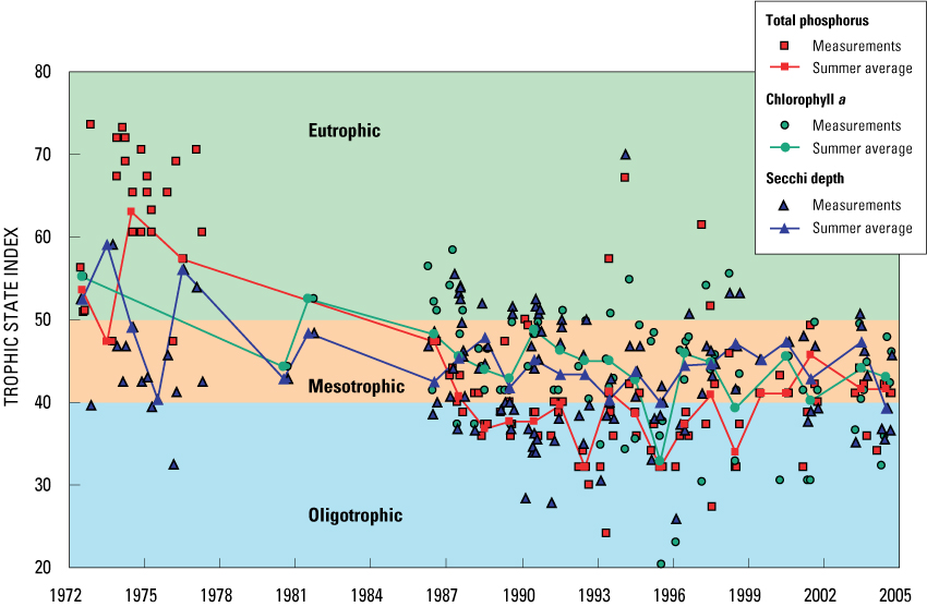
Phosphorus and nitrogen are essential nutrients for plant growth and are the nutrients that usually limit algal growth in most lakes. High nutrient concentrations can cause high algal populations (blooms); therefore, high nutrient loading can be the cause of accelerated eutrophication (that is, aging and increased productivity) of lakes. Concentrations of near-surface total phosphorus greater than about 0.017 to 0.020 mg/L indicate eutrophic conditions. Near-surface total phosphorus concentrations in Nagawicka Lake have ranged from 0.004 mg/L to greater than 0.12 mg/L (fig. 5). In the 1970s, total phosphorus concentrations were reported greater than 0.12 mg/L and spring turnover concentrations ranged from 0.05 to 0.11 mg/L. Most of the high concentrations of total phosphorus were measured during colder periods of the year. The high concentrations occurred before 1980, when the Hartland Sewage Treatment Plant discharged effluent into the Bark River upstream from the lake and runoff from confined livestock operations drained to the lake. The high total phosphorus concentrations decreased rapidly after the sewage effluent diversion in 1980 and the discontinuation of most livestock operations in the early and mid-1980s. Since 1986, summer average or growing-season (June through September) concentrations of near-surface total phosphorus have fluctuated from 0.007 mg/L in 1992 and 1995 to more than 0.020 mg/L in 1986; the summer average concentration of near-surface total phosphorus for this period was 0.012 mg/L, and the concentration during spring overturn was 0.014 mg/L (table 2). During 2003–04, the summer average concentration of near-surface total phosphorus was 0.014 mg/L, and the average concentration during spring overturn was 0.013 mg/L. Total phosphorus concentrations greater than 0.025 mg/L indicate eutrophic conditions, and from 0.012 to 0.024 mg/L indicate mesotrophic conditions. Therefore, the summer average total phosphorus concentrations indicate that before 1980, the lake was usually classified as eutrophic; however, in 1986 and thereafter the lake was typically mesotrophic and sometimes oligotrophic.
Table 2. Average near-surface summer (June through September) water quality and trophic state index (TSI) values for Nagawicka Lake, Wis.
[mg/L, milligram per liter; µg/L, microgram per liter; --, missing data]
| Average—all years | ||||||
| Average 1986–2004 | ||||||
| Average 2003–04 | ||||||
Figure 5. Measured Secchi depths, total phosphorus and chlorophyll a concentrations, and summer (June to September) average values at the deep hole in Nagawicka Lake, Wis., 1972–2004.
In the 1970s, near-bottom concentrations of total phosphorus were as high as 0.58 mg/L; but by the late 1980s, bottom concentrations rarely exceeded 0.10 mg/L. The increased phosphorus concentrations near the bottom in the 1970s indicate substantial release of phosphorus from the sediments. During 2003–04, however, near-bottom concentrations of total phosphorus increased very little over the summer (to maximums of 0.028 and 0.051 mg/L, respectively) after the onset of anoxic conditions. The very small increase in bottom total phosphorus concentrations as summer progresses indicates that the phosphorus release from the deep sediments of the lake has been greatly reduced with the reduction in phosphorus loading from the watershed.
Concentrations of near-surface total nitrogen (computed as the sum of Kjeldahl nitrogen and dissolved nitrite plus nitrate) ranged from 0.98 to 2.09 mg/L during the 1970s and from 1.37 to 1.78 mg/L during the late 1980s. During the summers of 2003 and 2004, near-surface total nitrogen concentrations ranged from 1.1 to 1.6 mg/L.
The ratio of the near-surface concentrations of total nitrogen to total phosphorus (N:P ratio) is often used to determine the potential limiting nutrient in a lake. The specific value of this ratio that determines which nutrient potentially is limiting differs under varied conditions such as water temperature, light intensity, and nutrient deficiencies (Correll, 1998); however, a ratio greater than about 16:1 by weight usually indicates that phosphorus should be the potentially limiting nutrient. The N:P ratios for 1970s data ranged from 19:1 to 49:1. Since the mid 1980s, the ratios have ranged from 68:1 to 126:1. Therefore, phosphorus typically should be the nutrient limiting algal growth in Nagawicka Lake and is the nutrient of concern when considering management efforts to improve water quality.
Chlorophyll a is a photosynthetic pigment found in algae and other green plants. Its concentration is commonly used as a measure of the density of the algal population in a lake. Concentrations between 2 and about 7 µg/L indicate mesotrophic conditions and greater than about 7–10 µg/L indicate eutrophic conditions. Concentrations greater than 20–30 µg/L usually are associated with algal blooms. Very few chlorophyll a data were available prior to 1980; the one value available was 12.2 µg/L measured in 1972.
Since 1986, near-surface chlorophyll a concentrations ranged from less than 1 to 17 µg/L (fig. 5), with an overall average summer concentration of 4.4 µg/L. Summer average concentrations ranged from 1.5 µg/L in 1995 to 12.2 µg/L in 1972. The summer average concentrations for 2003 and 2004 were 4.2 and 3.9 µg/L, respectively, or an average of 4.1 for both years. Therefore, summer average concentrations of chlorophyll a indicate that the lake typically is mesotrophic and has not been classified as eutrophic since prior to 1986.
To determine how surface concentrations of chlorophyll a in the lake respond to changes in near-surface concentrations of total phosphorus, summer average chlorophyll a concentrations were plotted against summer average total phosphorus concentrations. Summer average chlorophyll a concentrations increase as near-surface total phosphorus concentrations increase. With the linear relation in figure 6A, summer average total phosphorus concentrations explain 66 percent of the variance in summer average chlorophyll a concentrations.
Figure 6. Relation between summer average total phosphorus concentration and summer average A, chlorophyll a concentration and B, Secchi depth transparency in Nagawicka Lake, Wis.
The summer average (June through September) water clarity in Nagawicka Lake, as measured with a standard 8-in. Secchi disk, is 9.7 ft, but it has ranged from about 3.5 ft in 1973 (based on only one measurement) to 14.3 ft in 2004 (fig. 5). Individual summer measurements have ranged from about 3.5 ft in 1973 to 17.8 ft in 2004. During 2003 and 2004, the summer average Secchi depths were 8.0 ft and 14.3 ft, respectively, or an average of 11.2 ft for both years. Secchi depths less than 6 ft indicate eutrophic conditions, and from 6 to 13 ft indicate mesotrophic conditions, and greater than 13 ft indicate oligotrophic conditions. Therefore, average summer Secchi depths in Nagawicka Lake indicate the lake is typically mesotrophic, but is occasionally oligotrophic (table 2).
To determine how summer average Secchi depths respond to changes in near-surface phosphorus concentrations, summer average Secchi depths are plotted against summer average total phosphorus concentrations (fig. 6B). Summer average Secchi depths decrease as near surface total phosphorus concentrations increase. With the nonlinear relation in figure 6B, summer average total phosphorus concentrations explain about 33 percent of the variance in summer average Secchi depths. The limited variance explained with this relation may have been caused by much of the variability in water clarity being associated with calcite formation rather than chlorophyll a production.
All three trophic state indices, based on near-surface concentrations of total phosphorus and chlorophyll a and on Secchi depth, indicate that Nagawicka Lake can historically be classified from eutrophic to oligotrophic. In MY 2003 and MY 2004, the lake was typically mesotrophic to oligotrophic (fig. 7 and table 2). Better water clarity and lower chlorophyll a concentrations in the early part of summer (May and June) occasionally results in the lake being classified oligotrophic, but the periods of very good water quality are usually short lived and the lake is classified as mesotrophic by mid to late summer.
Figure 7. Trophic state index (TSI) values based on surface concentrations of total phosphorus and chlorophyll a, and Secchi depths, Nagawicka Lake, Wis., 1972–2004.
The index values based on total phosphorus concentrations indicate the lake to be slightly less eutrophic than the index values based on Secchi depths and chlorophyll a concentrations. In other words, the clarity is a little less than would be expected for the measured phosphorus concentrations, and chlorophyll a concentrations are a little higher than would be expected based on the measured phosphorus concentrations. The index values based on Secchi depths have not changed as dramatically as those based on phosphorus concentrations.
The water quality of Nagawicka Lake has fluctuated during the period of record (1972 to 2004). All three indices indicate that the trophic status of the lake has improved since 1972, and most of this change occurred before 1986. This improvement possibly was due to diversion of the sewage-treatment-plant discharge in 1980 and discontinued livestock operations near the lake.
Results of analyses of two sediment cores extracted from the deep hole of the lake by the WDNR in November 2003 were used to quantify changes in sedimentation rates, and reconstruct sediment and nutrient loading to, and water-quality of the lake (Garrison, 2004). The average annual sedimentation rate for Nagawicka Lake (0.067 g/cm2) was one of the highest determined for lakes that have been studied in Wisconsin. The rate has steadily increased since 1910, with the highest rates (0.12–0.16 g/cm2) occurring after 1980. The increased sedimentation rate was caused largely by precipitation of calcium carbonate (calcite or marl), common in hard-water lakes like Nagawicka. Changes in the sedimentation rate may have been caused by increased nutrient loading and increased photosynthetic activity of aquatic plants and algae, which increases the pH of the water. The increased pH in turn may have increased the rate of deposition of calcium carbonate and the coprecipitation of phosphorus. This coprecipitation process reduces the availability of phosphorus for use by algae and naturally serves as a buffer to protect the lake from high phosphorus input. Phosphorus concentrations in the sediment increased steadily from 1910 to about 1970. Since 1970, the phosphorus concentration in the sediment has remained high.
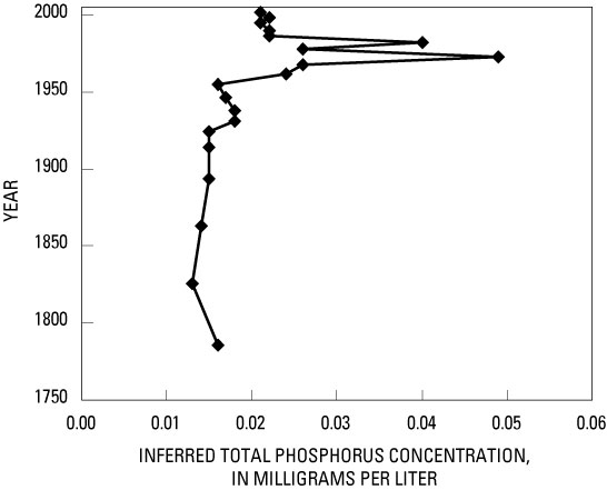
Changes in the diatom assemblages in the lake sediments can be used to describe changes in the nutrient concentrations in the water column. On the basis of diatom assemblages, historical phosphorus concentrations in the 1800s were low (approximately 0.015 mg/L; fig 8; from Garrison, 2004). Soil erosion and in-lake phosphorus concentrations and productivity increased after 1920 in response to the increase in agriculture and urbanization of the watershed during the first half of the 20th century. After about 1950, soil erosion decreased but nutrients from urban runoff continued to increase. Total phosphorus concentrations increased dramatically after 1950 and reached peak concentrations of about 0.040–0.050 mg/L from about 1970 through 1980 (fig. 8). Since 1980, total phosphorus concentrations have declined to about 0.020 mg/L, but remain slightly higher than the presettlement concentrations. These results are additional evidence that the water quality of Nagawicka Lake has changed historically and the water quality was worse around 1970 to 1980.
Figure 8. Estimated changes in summer total phosphorus concentrations based on changes in the diatom community in the sediment cores from Nagawicka Lake (from Garrison, 2004).
Because the productivity in Nagawicka Lake is limited by the input of phosphorus (based on N:P ratios), reduction in phosphorus input to the lake should improve water quality. Most of the phosphorus entering the lake is transported by water inputs; therefore, to quantify phosphorus inputs, it is necessary to quantify the water inputs. Water budgets for the lake were quantified for each of the two monitoring years.
The hydrology of Nagawicka Lake can be described in terms of components of its water budget. The water budget for a period of interest may be represented by the equation
∆S = (P + SWIn + GWIn) – (E + SWOut + GWOut), |
(4) |
where ∆S is change in the volume of water stored in the lake and is equal to the sum of the volumes of water entering the lake minus the sum of the volumes of water leaving the lake. Water enters the lake as precipitation (P), surface-water inflow (SWIn), and ground-water inflow (GWIn). Water leaves the lake through evaporation (E), surface-water outflow (SWOut), and ground-water outflow (GWOut). Each term of the water budget was computed on a daily basis.
Changes in the volume of the lake were determined from water elevations measured continuously at the dam (fig. 3). Lake stage fluctuated from a minimum of 7.58 ft (relative to an arbitrary datum) to a maximum of 8.48 ft in MY 2003, and from a minimum of 7.60 ft to a maximum of 8.73 ft in MY 2004 (fig. 9). To simplify computations, the area of the lake was assumed to be constant (986 acres) over the relatively small range in stage during the study (1.16 ft). The change in storage from beginning to end of the year for MY 2003 was +50 acre-ft, and for MY 2004 it was -250 acre-ft (less than 1 percent of the volume of the lake).
Figure 9. Daily water levels of Nagawicka Lake and daily average streamflow in the Bark River at the inlet and outlet stream gages of Nagawicka Lake at Delafield, Wis., November 2002–October 2004.
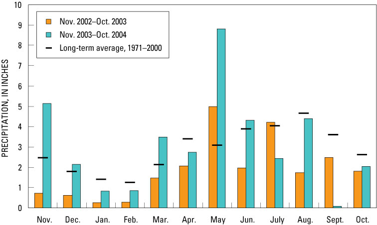
During the 2-year study, total daily precipitation was measured at the dam at Delafield during nonfreezing periods. During winter, precipitation at the lake was estimated by averaging daily data from the National Weather Service stations (National Climatic Data Center, 2002–2004) at Oconomowoc (about 6 mi northwest of the lake) and at Waukesha (about 9 mi southeast of the lake). Precipitation on the lake surface during MY 2003 was 22.65 in. (1,860 acre-ft) and during MY 2004 was 37.29 in. (3,064 acre-ft) (table 3). Precipitation was 66 percent of the long-term (1971–2000) average during 2003 and was 109 percent of the long-term average in 2004. Monthly precipitation during each study year is compared to the 1971–2000 average monthly precipitation in figure 10. In MY 2003, only the May and July precipitation totals were above or near the long-term average; all other monthly totals were much below average. In MY 2004, totals for November, December, March, May, June, and August were much above or near average. The total of 8.8 inches in May was 285 percent of average for that month.
Figure 10. Precipitation at Nagawicka Lake, Wis., during November 2002–October 2004, relative to long-term average precipitation.
[MY, monitoring year November–October; NA, not applicable]
average |
2-year total |
|||
| Precipitation | ||||
| Bark River (inlet) | |
|||
| Near-lake drainage | ||||
| Subwatershed 1 | |
|||
| Subwatershed 2 | |
|||
| Subwatershed 3 | |
|||
| Ground water | |
|||
| Total input | ||||
| Evaporation | ||||
| Bark River (outlet) | ||||
| Ground water | ||||
| Total output | ||||
Evaporation from the lake surface was estimated by first obtaining the average monthly long-term pan evaporation computed for Madison and Milwaukee (Farnsworth and Thompson, 1982) for nonsummer months; next, the measured monthly pan evaporation values for June through September at the National Weather Service Arlington Farm station (Ed Hopkins, Wisconsin State Climatology Office, written commun., 2004) were adjusted for the difference in location to Nagawicka Lake. A lake/pan coefficient was then applied to the average monthly pan evaporation to determine lake evaporation. An annual lake/pan coefficient of 0.78 was used for Nagawicka Lake (Farnsworth and others, 1982). It was assumed that evaporation from the lake was zero during periods of ice cover, and that the lake was ice-covered from December through March. Annual evaporation in MY 2003 and 2004 was estimated to be 30.07 in. (2,471 acre-ft) and 27.13 in. (2,229 acre-ft), respectively (table 3).
Daily inflow from the Bark River, the main perennial tributary to the lake, was measured at the USGS streamflow-gaging station at Nagawicka Road (fig. 3). The drainage area above this location is 35.9 mi2. The annual average streamflow at this site was 16.0 ft3/s (11,590 acre-ft) in MY 2003 and 25.3 ft3/s (18,290 acre-ft) in MY 2004 (table 3). Flows of the Bark River are naturally regulated, having a sustained base flow and relatively low peak flows (see fig. 9). Given the departures of annual precipitation from the long-term average, flow in the Bark River would be expected to be below normal in MY 2003 and above normal in MY 2004. Flow measured at the downstream long-term USGS station on the Bark River near Rome in Jefferson County (about 15 mi southwest of the lake) was 52 percent of the 25-year average for MY 2003 and 108 percent of the average for MY 2004 (Waschbusch and others, 2004, 2005).
Small drainages or subwatersheds making up the near-lake drainage area (fig. 2) also contribute runoff to the lake. These consist of subwatershed 1 on the southeast side of the lake (with commercial areas including the Interstate 94/State Highway 83 intersection), the Lapham Hill area on the south side of the lake (subwatershed 2), and the remaining urban/residential ungaged area surrounding the lake (subwatershed 3).
The commercially developed subwatershed 1, with an area of about 790 acres, produced no flow at its drainage outlet (fig. 11) most of the time but responded rapidly to rainfall events. In MY 2003, subwatershed 1 produced measurable flow on 24 days; the highest daily average flow was 13.3 ft3/s on May 11. In MY 2004, subwatershed 1 produced measurable flow on 74 days and the highest average flow was 22.3 ft3/s on August 3. The maximum recorded peak flow in MY 2003 was about 90 ft3/s (July 29), and the maximum peak flow in MY 2004 was about 240 ft3/s (August 3). Runoff events were frequent during the wet period in May and June 2004. Subwatershed 1 was estimated to contribute 125 acre-ft of runoff in MY 2003 and 414 acre-ft of runoff in MY 2004.
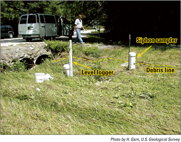
Figure 11. Stream gage at the outlet of subwatershed 2 at Delafield, Wis., with water-level logger and siphon sampler. (Note high-water debris line from peak flow of August 3, 2004.)
The southern, mostly undeveloped subwatershed 2, with an area of about 1,230 acres, has an outlet to the lake on the south shore. Flow from the outlet is regulated by a detention pond and was perennial throughout the study period. Subwatershed 2 contributed 386 acre-ft of runoff in MY 2003 and 670 acre-ft of runoff in MY 2004.
Runoff from subwatershed 3, which includes the remainder of the City of Delafield and the Village of Nashotah and has a drainage area of about 2,480 acres, was estimated by use of the Source Loading and Management Model (SLAMM; Pitt and Voorhees, 1993). SLAMM is commonly used to generate runoff volumes and loads from urban areas. SLAMM was first calibrated using data from subwatershed 1, which was the subwatershed with the most similar land use to subwatershed 3. The parameter files used in SLAMM (available on the USGS web page http://wi.water.usgs.gov/slamm/) did not have runoff curves for woodlots, so the files were updated with the latest runoff monitoring data from several recent USGS investigations in Wisconsin (Garn, 2002; Graczyk and others, 2003). For woodlots, a runoff coefficient of 0.0008 was used for storms less than 3.2 in. and 0.0023 for storms greater than 3.2 in. Because subwatershed 1 produced no flow most of the time and some smaller rain events did not produce measured runoff, only the runoff events from SLAMM that coincided with actual flow events measured at the subwatershed outlet were used. Runoff predicted by SLAMM from subwatershed 1, after accounting for drainage and pond stormwater-control practices, totaled 133 acre-ft in MY 2003 and 368 acre‑ft in MY 2004. The results from SLAMM were within 10–20 percent of the estimates in table 3. The runoff from the individual land-use areas in subwatershed 3 was then estimated with SLAMM, with the assumption that runoff was contributed at a rate per unit area similar to the areas in subwatershed 1. Subwatershed 3 contributed an estimated 542 acre‑ft of runoff in MY 2003 and 1,081 acre-ft of runoff in MY 2004.
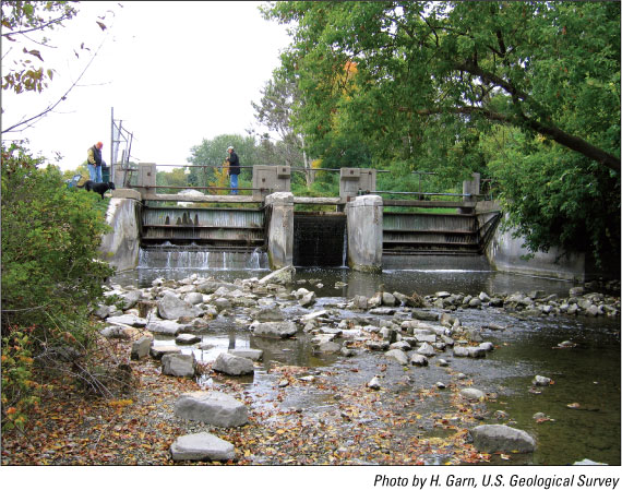
Surface-water outflow from the lake is to the Bark River at the dam in Delafield (fig. 12). Manual gate settings in the dam are used to release water from the lake. Outflows into the Bark River through the main gates were monitored approximately 200 ft downstream from the dam. In addition to the main gates operated by the City of Delafield, there is also a privately operated outlet to an old mill race or ditch that is controlled with stop logs (flash boards) on the south side of the dam (Michael Scaff, City of Delafield, oral commun., 2005). Outflow in this ditch bypasses the stream gage on the Bark River and was therefore estimated from manual flow measurements and observations of board settings and lake stage. The total daily outflows from the lake are shown in figure 9. Total annual surface-water outflow was 12,400 acre-ft in MY 2003 and 23,710 acre-ft in MY 2004.
Figure 12. Nagawicka Lake Dam at Delafield, Wis.
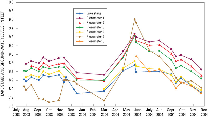
Ground-water inflow was calculated on the basis of ground-water recharge estimates for the areas contributing ground water to the Bark River. A water-table map by Gonthier (1975) indicated that ground-water flow was toward Nagawicka Lake from the north, east, and south. Water levels in five shallow, nearshore piezometers along the north, east, south, and southwest sides of the lake (fig. 13) confirmed that the ground-water gradient was toward the lake in these areas. Gonthier’s map indicated that ground water flowed away from the west side of the lake. Water levels in a single piezometer (no. 5) near the northwestern shore of the lake (fig. 3) confirmed that the ground-water gradient generally was away from the lake in this area. However, during the wet period in May through June 2004, water levels in piezometer 5 indicated that ground water in this area reversed direction and flowed into the lake.
Figure 13. Ground-water levels in piezometers in relation to lake stage, 2003 and 2004, at Nagawicka Lake, Wis. (Note piezometer 4 froze during the winter.)
In order to estimate the direct ground-water contribution to the lake, several simplifying assumptions were necessary. The unit-area inflow rate for ground water entering the lake was assumed to be the same as the rate for the area contributing base flow upstream from the Bark River streamflow station. The base flow in the Bark River was assumed to be completely supplied by ground water and the contributing area was assumed to be roughly equal to the area contributing surface water because Gonthier (1975) did not delineate the ground-water contributing area for the entire Bark River watershed. The base flow of the Bark River, determined by hydrograph separation and expressed as inches of water on the contributing area, was 4.0 in. in MY 2003 and 6.4 in. in MY 2004. For comparison, D. Feinstein (U.S. Geological Survey, written commun., 2005) and Cherkauer and Ansari (2005) reported average annual recharge rates for northwestern Waukesha County as 3–10 in/yr.
The estimated ground-water discharge to Nagawicka Lake, based on a direct contributing area of 3,080 acres from the water-table map by Gonthier (1975) and 4.0 in. per unit ground-water contributing area, was about 1,020 acre-ft in MY 2003 (table 3). Based on 6.4 in. per unit of ground-water contributing area in MY 2004, ground-water inflow was about 1,640 acre-ft. Ground-water discharge from the lake (leakage) was not measured but should be small, given the small percentage of shoreline with a gradient away from the lake, and therefore was assumed to be one tenth of the ground-water input to the lake. Estimated ground-water outflow was 102 acre-ft in MY 2003 and 164 acre-ft in MY 2004 (table 3).
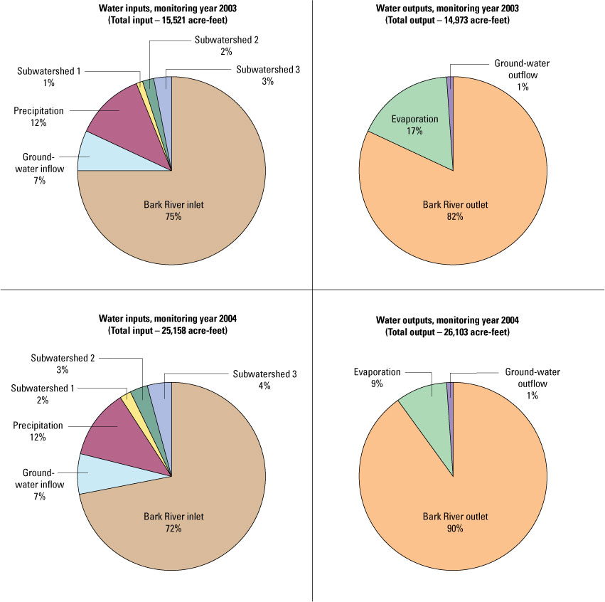
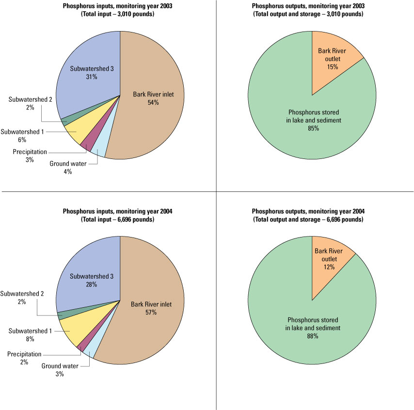
The Bark River is the largest source of water to Nagawicka Lake, supplying about 74 percent of all water entering the lake during the 2-year study period (table 3 and fig. 14). Other sources were precipitation (about 12 percent), near-lake surface-water inflow (about 8 percent), and ground water (about 6 percent). Inputs in MY 2004 (about 25,160 acre-ft) were greater than inputs in MY 2003 (15,520 acre-ft) because of the wet spring in MY 2004. The average residence time, or the length of time required for water entering the lake to completely replace the volume of water within the lake, ranged from 1.01 to 1.64 years on the basis of total inflows for MY 2004 and MY 2003, respectively, or 1.25 years on the basis of the 2 years of data averaged. Using available data at the time and a different lake volume, the Southeastern Wisconsin Regional Planning Commission (1999) had previously estimated that the Bark River and other surface-water sources represented 89 percent of the inflow, and that the lake had a residence time of about 1.7 years.
Figure 14. Water budget for Nagawicka Lake, Wis., for monitoring years 2003 and 2004 (%, percent).
The total annual water outputs from the lake were similar to the total inputs and resulted in little change in storage from the beginning to the end of each study year. The Bark River outlet from the lake, on average, accounted for about 88 percent of the total outflow, and evaporation accounted for about 11 percent of the output.
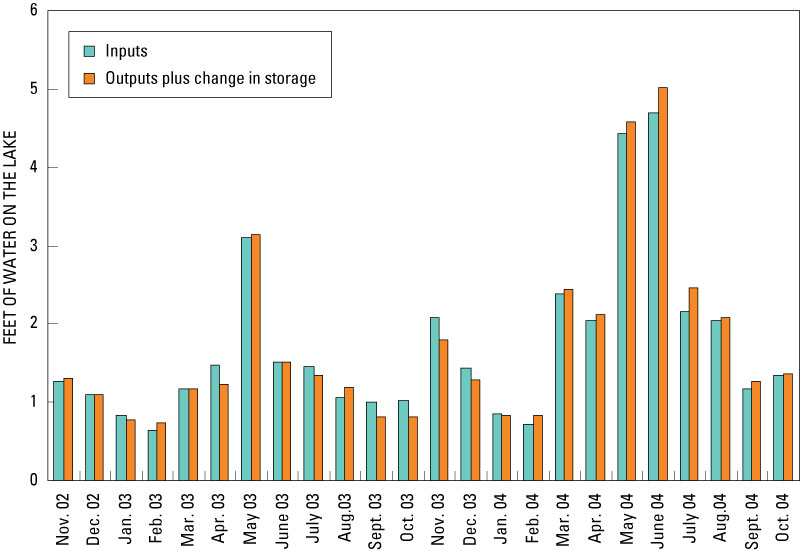
The quality or accuracy of the water budget can be evaluated by comparing the monthly sum of all inputs with the sum of all outputs and the change in storage for the lake during the 2-year study period, expressed as feet on the lake (fig. 15). More than 85 percent of the total input and output volumes were measured daily. The differences between calculated inputs and outputs reflect the cumulative errors in the estimates of daily water-budget components. The largest monthly differences, about 21 percent, were for September and October 2003. The assumptions that were necessary in estimating evaporation, ground-water inflow and outflow, and runoff from ungaged areas, are likely to have caused the differences between calculated and measured water levels. Overall, however, the errors were small, and annual differences were within about 3 percent.
Figure 15. Monthly total water inputs and outputs plus storage change for Nagawicka Lake, Wis., November 2002–October 2004.
To help define where the phosphorus in Nagawicka Lake originates and how much may be controllable, a detailed phosphorus budget was computed for each monitoring year. Sources of phosphorus to the lake include precipitation, surface- and ground-water inflow, and contributions from septic systems. Phosphorus is removed from the lake through surface- and ground-water outflow and by deposition to the lake sediments.
Phosphorus input to the lake from precipitation was estimated by multiplying daily precipitation volumes by an estimated phosphorus concentration of 0.016 mg/L. Field and Duerk (1988) determined that bulk precipitation at Delavan Lake, which is about 35 mi. south of Nagawicka Lake, had an average phosphorus concentration of 0.016 mg/L. Phosphorus inputs to the lake from precipitation were 79 lb in MY 2003 and 130 lb in MY 2004 (table 4).
Table 4. Summary of phosphorus-budget components for Nagawicka Lake, Wis., monitoring years 2003–04.
[MY, monitoring year November–October]
| Precipitation | ||||
| Bark River (inlet) | ||||
| Near-lake drainage
|
||||
| Subwatershed 1 | ||||
| Subwatershed 2 | ||||
| Subwatershed 3 | ||||
| Ground water | ||||
| Total input | ||||
| Bark River (outlet) | ||||
| Retained in lake1 | ||||
| Total output and storage | ||||
1 Assumed that ground-water output was negligible from lake and was included with storage.
Phosphorus loads for the continuously monitored sites at the Bark River inlet to the lake, subwatershed 2, and the outlet from the lake were computed by use of techniques for integrating streamflow and concentration described by Porterfield (1972). Detailed load and concentration data for each year were published in the annual USGS water-data report series (Waschbusch and others, 2004; 2005). Phosphorus loads for the other sites were determined by various methods that depended on the quantity of data available.
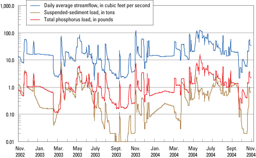
Phosphorus contributions measured at the Bark River inlet monitoring site at Nagawicka Road (fig. 3) originate from the upper watershed, including the villages of Hartland and Merton. Total phosphorus concentrations for 207 samples collected in the Bark River during the 2-year study ranged from 0.018 to 0.589 mg/L. The median concentration was 0.111 mg/L and the flow-weighted average concentration was 0.066 mg/L. On average, about 21 percent of total phosphorus was in the dissolved form. Daily total phosphorus and suspended-sediment loads at the Bark River inlet are shown in figure 16. The total quantity of phosphorus delivered to the lake by the Bark River was 1,628 lb in MY 2003 and 3,767 lb in MY 2004 (table 4). Therefore, yields from the Bark River watershed were 45.3 lb/mi2 in MY 2003 and 105 lb/mi2 in MY 2004. These yields are very low compared to other rural watersheds monitored in southeastern Wisconsin (Corsi and others, 1997). The associated loads of suspended sediment were 627 tons in MY 2003 and 1,461 tons in MY 2004.
Figure 16. Daily average streamflow, and loads of total phosphorus and suspended sediment at the Bark River inlet to Nagawicka Lake, Wis., November 2002–October 2004.
Phosphorus loading to the lake from the remainder of the Nagawicka Lake drainage area downstream from the Bark River inlet gage (referred to herein as “near-lake drainage”) was divided into contributions from subwatersheds 1, 2, and 3 (fig. 2). Subwatersheds 1 and 3 are the urbanized areas with more than 50 percent commercial, industrial, or residential land use.
Subwatershed 1, the commercially developed drainage that includes the Interstate 94/State Highway 83 intersection (fig. 2), was monitored continuously for flow; water-quality samples were collected by the grab method or by a siphon sampler. During the 2-year study, 25 water-quality samples were obtained at the subwatershed outlet. Total phosphorus concentrations in these samples ranged from 0.101 to 1.680 mg/L, with mean and median concentrations of 0.510 and 0.368 mg/L, respectively. Suspended-sediment concentrations ranged from 8.0 to 3,370 mg/L.
Monthly loads were computed as the product of total monthly flow volumes and the flow-weighted average concentration based on the concentrations and corresponding flows for the samples collected in each month. Annual loads were then computed by summing the loads for the individual months. The total quantity of phosphorus delivered to the lake by subwatershed 1 was 168 lb in MY 2003 and 559 lb in MY 2004, or an average annual yield of 294 lb/mi2 (table 4).
Water and phosphorus loads from subwatershed 1 were also estimated with SLAMM. Runoff volumes predicted by SLAMM from subwatershed 1, after accounting for drainage and pond stormwater-control practices, were within 10–20 percent of that measured. SLAMM was applied to subwatershed 1 with all of the standard coefficients except the coefficients for woodlots: a concentration of 1,643 mg/kg was used for particulate phosphorus (which resulted in an average total phosphorus concentration of 0.69 mg/L). Simplifying assumptions for pond design were used to model the many small detention and infiltration basins throughout the subwatershed. With the calibrated SLAMM model that included drainage and detention pond outfall controls, the estimated load of phosphorus from subwatershed 1 was 80 lb in MY 2003 and 210 lb in MY 2004, for an average yield of about 117 lb/mi2. If outfall controls associated with detention ponds in the subwatershed were removed from the model, the estimated load of phosphorus from subwatershed 1 was 200 lb in MY 2003 and 500 lb in MY 2004, for an average yield of 283 lb/mi2. This increase in the load suggests that the detention ponds should have reduced the phosphorus load by 59 percent. The total modeled loads from the subwatershed were then compared with measured loads. Estimates from SLAMM without the detention ponds compare more closely with the measured loads (294 lb/mi2) than those of the fully calibrated model, which suggests that the detention ponds may not be as efficient in phosphorus removal as modeled. Another explanation for the difference may be the assumptions that were used in SLAMM. On the basis of these results, SLAMM (without outfall controls associated with detention ponds) was used to estimate the phosphorus loads from subwatershed 3 (the ungaged urbanized area).
Phosphorus loads from subwatershed 2, the largely undeveloped drainage south of the lake (fig. 2), were based on 20 samples collected at the outlet. There was continuous flow from this drainage during the study because water was gradually released from a detention pond immediately upstream from the mouth. Total phosphorus concentrations in samples ranged from 0.015 to 0.175 mg/L, with a flow-weighted average concentration of 0.067 mg/L. The total phosphorus load from subwatershed 2 was estimated to be 60 lb in MY 2003 and 132 lb in MY 2004 (table 4).
Phosphorus loads from subwatershed 3 were estimated by SLAMM after it was calibrated with monitoring data from subwatershed 1. The total estimated phosphorus load from subwatershed 3 was 941 lb in MY 2003 and 1,878 lb in MY 2004, for an average annual yield of 363 lb/mi2 (table 4). Based on these estimated loads, the flow-weighted average total phosphorus concentration in runoff from subwatershed 3 was 0.66 mg/L. The median yield from urban watersheds reported by Corsi and others (1997) was 318 lb/mi2 , with a range from 133 to 1,210 lb/mi2. Therefore, the load estimated by SLAMM was considered to be reasonable.
Phosphorus is discharged from Nagawicka Lake into the Bark River (fig. 17) through the main outlets of the dam and the mill race. Total phosphorus concentrations in 32 samples collected from the lake outflow during the 2‑year study period ranged from 0.006 to 0.053 mg/L, with a flow-weighted average concentration of 0.012 mg/L. Total output of phosphorus released from the lake into the Bark River was estimated to be 453 lb in MY 2003 and 791 lb in MY 2004 (table 4).
Figure 17. Daily average streamflow, and loads of total phosphorus and suspended sediment at the Bark River outlet from Nagawicka Lake, Wis., November 2002–October 2004.
The total phosphorus delivered to the lake by ground-water inflow was estimated to be 134 lb in MY 2003 and 230 lb in MY 2004 (table 4). This estimate is based on an average concentration of 0.053 mg/L in water from the piezometers around the lake (table 5) and the total ground-water inflow in table 3. Natural background phosphorus concentrations in ground water were considered to be generally less than 0.03 mg/L. Concentrations in water from piezometers 3, 4, and 5 (fig. 3) were elevated above the background concentration, possibly because of effects from septic systems and other human activities.
Table 5. Concentrations of dissolved phosphorus in ground water from piezometers at Nagawicka Lake, Wis.
[mm/dd/yy, month/day/year; <, less than; --, not available; all concentrations are given in milligrams per liter]
concentration |
||||||
The ground-water outflow component was assumed to be small and for simplicity was combined with the lake-storage component in the phosphorus budget and was estimated by differences in the phosphorus budget. This resulted in 2,557 lb of phosphorus being either retained in the sediments or lost from the lake to the ground water in MY 2003 and 5,905 lb retained in the sediments or lost from the lake in MY 2004 (table 4).
Approximately 3,000 lb of phosphorus was delivered to Nagawicka Lake in MY 2003 compared to approximately 6,700 lb in MY 2004, for an average annual load of approximately 4,850 lb of phosphorus (table 4). The largest source of phosphorus entering the lake is the Bark River, which delivered about 56 percent of all the phosphorus entering the lake (fig. 18), compared with about 74 percent of the water input. The next largest contributions are from the urbanized subwatersheds 1 and 3 in the near-lake drainage area, which contributed about 8 and 29 percent, respectively, of the phosphorus loading to the lake. Collectively, these two areas contributed about 1,770 lb of phosphorus, but only about 5 percent of the total water input. Phosphorus inputs from subwatershed 2, precipitation, and from ground water were comparatively minor. Phosphorus loading in MY 2004 was about 2.2 times that in MY 2003 because of larger rainstorms and accompanying greater runoff.
Figure 18. Phosphorus budgets for Nagawicka Lake, Wis., for monitoring years 2003 and 2004 (%, percent).
Surface-water outflow into the Bark River downstream from the lake removed about 450 lb of phosphorus in MY 2003 and 800 lb in MY 2004, which on average amounted to about 13 percent of the inputs. Therefore, about 87 percent of incoming phosphorus was retained in the lake sediments or lost to the ground water.
The phosphorus budgets developed as part of previous lake-management plans (Southeastern Wisconsin Regional Planning Commission, 1979 and 1999) estimated the total annual external phosphorus input to the lake to be about 11,300 lb in the 1970s and 13,100 lb in the mid-1990s. In the 1970s budget, most of the external loading was attributed to sewage-treatment-plant effluent (4,300 lb/yr, or about 38 percent) and livestock operations in the nearlake drainage area (3,600 lb/yr or about 32 percent). The phosphorus budget for the mid-1990s was based on typical unit-area export rates (yields from the Wisconsin Lake Modeling Suite, WiLMS) from the different land uses/land covers in the Nagawicka Lake watershed. Of the total input estimated for the mid-1990s, it was further estimated that the Bark River contributed 10,800 lb (82 percent), the near-lake drainage area contributed 2,200 lb (17 percent), and precipitation contributed about 100 lb (1 percent). About 72 percent of the total phosphorus load was estimated to originate from rural sources and 27 percent from urban sources. However, phosphorus yields from the Nagawicka Lake watershed in this study were found to be much less than those from other areas of Wisconsin with similar land use. Therefore, the phosphorus loads to the lake in the 1970s appear reasonable; however, loadings for the mid-1990s appear to have been greatly overestimated.
To delineate further where the phosphorus entering Nagawicka Lake originates, the average annual load for MY 2003–04 was allocated to various land uses/land covers on the basis of the export rates (also referred to as unit-area loads or yields) in table 6 and the percentage of the watershed with the various types of land use/land cover. Loads computed on the basis of these export rates provided a load similar to that estimated for MY 2003–04. The yields required to match the measured loads were relatively low compared to those used in similar lake-modeling studies in Wisconsin (Panuska and Kreider, 2002; Robertson and others, 2002) and low compared to those measured in streams in southern Wisconsin (Corsi and others, 1997). The yields, however, were similar to those used in eutrophication-modeling studies on Pike Lake, Wisconsin (about 15 mi north of Nagawicka Lake), with two exceptions: (1) the yield from row-crop areas was increased from 168 to 195 lb/mi2 (still low compared to those of Panuska and Kreider, 2002), and (2) the yield from barren land was not included in the Pike Lake study (Rose and others, 2004). The total contribution from each land-use/land-cover category and source is listed in table 6. Of the overall phosphorus load, agricultural land contributed 47 percent of the load, and rural residential areas contributed about 17 percent of the load. Urban areas, although having relatively high unit-area loading, contributed only about 10 percent of the entire load because they represent only a small percentage of the entire watershed.
Table 6. Allocation of phosphorus loading to land-use/land-cover categories in the Nagawicka Lake watershed.
[lb, pound; lb/mi2, pound per square mile; NA, not applicable]
and other sources |
(acres) |
total area |
total load |
||
| Urban and commercial, high and moderate density | |||||
| Rural residential | |||||
| Agriculture (cropland) | |||||
| Pasture/grassland | |||||
| Forest and shrubland | |||||
| Open water | |||||
| Wetland | |||||
| Barren | |||||
| Precipitation (lake surface) | |||||
| Ground water | |||||
| Total | |||||
Empirical eutrophication models that relate phosphorus loading to measured water quality in lakes can be used to determine whether the water quality of Nagawicka Lake responds to phosphorus loading in a similar manner as most other lakes, or, because it is a calcareous lake, whether the lake responds differently. If the empirical models are applicable to Nagawicka Lake, they can be used to determine how the water quality of the lake should respond to future changes in phosphorus loading. These empirical models were developed by comparing hydrologic and phosphorus loadings for many different lakes and reservoirs with parameters describing lake-water quality, such as near-surface total phosphorus and chlorophyll a concentrations and Secchi depth. Several of these empirical models are part of the Wisconsin Lakes Modeling Suite (WiLMS) (Panuska and Kreider, 2002).
To determine whether the water quality of Nagawicka Lake responds like that of most other lakes, and whether the empirical models can be used to describe the water-quality response, the hydrology and phosphorus loading for MY 2003–04 (table 7) and for the 1970s (scenarios 1 and 2, respectively) were input into the models within WiLMS, and the simulated phosphorus concentrations were compared with measured concentrations. Scenario 1 involves a simulation of the base case (MY 2003–04) with which other simulations were compared. The hydrology of the 1970s, in scenario 2, was assumed to be similar to that of MY 2003–04; however, the phosphorus loading was different.
Table 7. Annual phosphorus loading associated with various scenarios simulated with the models within the Wisconsin Lakes Modeling Suite (WiLMS; Panuska and Kreider, 2002).
[lb, pound; mg/L, milligram per liter; MY, monitoring year]
loading (lb) |
controllable phosphorus loading (lb) |
(mg/L) |
(mg/L) |
in phosphorus concentration (percent) |
||
| Average of MY 2003–04 (base scenario) | ||||||
| Average loading for the 1970s | ||||||
| 50-percent reduction | ||||||
| 25-percent reduction | ||||||
| 25-percent increase | ||||||
| 50-percent increase | ||||||
| 75-percent increase | ||||||
| 100-percent increase | ||||||
| Buildout of subbasins 1 and 3 | 4,780 | 4,490 | 0.035 | 0.014 | -1 | |
| Buildout of subbasins 1 and 3, with nonpoint controls | 3,875 | 3,585 | 0.03 | 0.011 | -19 | |
1 Percent reductions and increases in controllable phosphorus loading from the base scenario (MY 2003–04).
2 Scenario assumes all phosphorus loading is similar to base scenario (MY 2003–04) except that from subbasins 1 and 3, which are described in the text.
To predict the expected changes in water quality in Nagawicka Lake in response to future changes in phosphorus loading, eight additional scenarios were simulated with the models in WiLMS. Six watershed-wide strategies are presented in scenarios 3–8 to determine the general response in water quality to changes in hypothetical phosphorus loading. In these scenarios, all controllable phosphorus loading (not including that from precipitation and ground water) was decreased by 50 and 25 percent, and then increased by 25, 50, 75, and 100 percent, respectively (table 7). Scenarios 9 and 10 include changes in loading from anticipated urban residential and commercial development throughout the watershed (herein referred to as “buildout”) described by SEWRPC (2001).
On the basis of acreages provided by SEWRPC, about an additional 1,500 acres of urban development could potentially result from full buildout conditions. Of the 1,500 acres, 500 acres would be in subwatersheds 1 and 3, and 1,000 acres would be in the area upstream from the Bark River stream gage. In subwatersheds 1 and 3, about 270 acres of cropland and 230 acres of pasture and grassland would be converted to urban and commercial land. In the area upstream from the Bark River stream gage, 700 acres of cropland, 200 acres of pasture and grassland, and 100 acres of forest and shrubland would be converted to 850 acres of rural residential land and to 150 acres of urban and commercial land. With these changes in land use under assumed full buildout (scenario 9), the total annual phosphorus load to the lake should decrease from 4,850 to 4,780 lb; a reduction of 70 lb (or an overall decrease in nonpoint-source loading of about 1.5 percent). The total load from subwatersheds 1 and 3 should increase by about 50 lb, from about 1,770 lb to about 1,820 lb.
Scenario 10 represents the changes in phosphorus loading that would be anticipated with full buildout in the watershed, but with stormwater and nonpoint controls added in subwatersheds 1 and 3 to achieve a 50-percent reduction in loading from these areas. With these changes, the annual phosphorus loading from subwatersheds 1 and 3 is estimated to decrease to about 910 lb (an overall decrease in nonpoint-source loading of 21 percent). The total annual phosphorus load is estimated to be about 3,875 lb.
Of the 13 empirical models contained in WiLMS, 6 were applicable to the hydrologic system of Nagawicka Lake; therefore, to determine whether these models were capable of simulating phosphorus concentrations in this calcareous lake, the morphometry of the lake and the average hydrologic and phosphorus loadings for MY 2003–04 and the 1970s were input into these models to simulate near-surface total phosphorus concentrations. All of the models within WiLMS use annual hydrologic and phosphorus loadings, but simulate water quality for discrete seasons. There are no calibration factors in WiLMS, but the output from the models can be adjusted to account for model biases.
The average simulated summer concentration of total phosphorus for Nagawicka Lake for MY 2003–04 (scenario 1) was 0.035 mg/L (table 8). This value is 2.5 times the average summer concentration measured in the lake (0.014 mg/L). The average simulated summer concentration of total phosphorus for the 1970s (scenario 2) was 0.072 mg/L, compared to 0.038 measured in the 1970s. The simulated value again was about twice the average measured value.
Table 8. Estimated water quality in Nagawicka Lake, Wis., in response to the average annual phosphorus loading in MY 2003–04 and 1970s based on the models within the Wisconsin Lakes Modeling Suite (WiLMS; Panuska and Kreider, 2002).
[lb, pound; mg/L, milligram per liter; m/yr, meter per year]
estimation (mg/L) |
estimation (mg/L) |
||
| Canfield and Bachman, 1981 (natural lakes) | |||
| Canfield and Bachman, 1981 (artificial lakes) | |||
| Rechow, 1979 (general lakes) | |||
| Rechow, 1977 (water load, 164 ft/yr) | |||
| Vollenweider, 1982 (general lakes) | |||
| Vollenweider, 1982 (shallow lakes) | |||
| Average of summer models | |||
| Measured summer concentration | |||
| Correction factor (unitless) | |||
| Average of annual models | |||
| Measured annual concentration | |||
| Correction factor (unitless) | |||
Although the models overpredict the phosphorus concentration in this calcareous lake, the models appear to consistently overpredict the concentrations by a factor of about 2.2. Therefore, the average summer concentration of total phosphorus can be predicted by dividing the average predicted concentration by 2.2 and then subtracting 0.002 mg/L. The small bias (0.002 mg/L) was a result of equally weighting the results for scenarios 1 and 2, but using only scenario 1 as the base case. The apparent loss of about 50 percent of the phosphorus in the lake (corresponding to the overprediction of the models) is consistent with that expected with coprecipitation of phosphorus with calcite and the reduction of phosphorus release from the deep sediments, as suggested by Grobbelaar and House (1995), and possibly the external phosphorus load which may have abnormally high amounts of nonavailable phosphorus (Stauffer, 1985). The slight decrease in the correction factor from 2.5 for 2003–04 to 1.9 for the 1970s could have been caused by the coprecipitation of phosphorus being overwhelmed by the increased loading of phosphorus and dissolved organic matter in the 1970s that increased productivity in the lake and increased the release of phosphorus from the bottom sediments.
The models were not as consistent in predicting the annual average total phosphorus concentration in Nagawicka Lake as they were at predicting summer average concentrations. The annual average simulated phosphorus concentration for MY 2003–04 (scenario 1) was 0.033 mg/L compared to a measured concentration of 0.013 mg/L (overestimated by a factor of 2.5), whereas the models accurately predicted the annual average concentration for the 1970s (a simulated value of 0.068 mg/L compared to a measured value of 0.067 mg/L). The models may have overestimated the annual average phosphorus concentration in the lake in MY 2003–04 because of coprecipitation of phosphorus and dissolved organic matter with calcite, negligible release of phosphorus from the deep sediments, and external phosphorus loading with abnormally high amounts of nonavailable phosphorus. The models may have more accurately simulated total phosphorus concentrations in the 1970s because geochemical processes in Nagawicka Lake were more like those in a typical lake; specifically, internal release of phosphorus from the deep sediments was greater, and precipitation of calcite and phosphorus was less during colder times of the year when photosynthesis (and pH) were low and cooler water temperatures prevailed. Almost all of the very high phosphorus concentrations were measured during cold periods of the year, when little calcite precipitation is expected. The high concentrations measured during cooler periods is consistent with that found by Stauffer (1985) in other calcareous lakes. Therefore, the results of the models can be used to predict summer average total phosphorus concentrations for changes in phosphorus loading by means of a simple linear relation applied to model results, but they are questionable for predicting changes in annual average total phosphorus concentrations.
The phosphorus concentrations in Nagawicka Lake have responded rapidly to the reduction in phosphorus loading between the late 1970s and early 1980s. By 1987, the lake was classified as mesotrophic to oligotrophic with respect to total phosphorus and chlorophyll a concentrations and Secchi depth. Water quality of noncalcareous lakes typically remains degraded for several years after reduction in phosphorus loading because of the continued release of phosphorus from the sediments of the lake, especially during anoxic periods (for example, Lake Sammamish, Wash.; Welch and others, 1986). However, the precipitation of calcite in calcareous Nagawicka Lake appears to trap the phosphorus in the deep sediments, as evidenced by the very small increase in phosphorus concentrations just above the deep bottom sediments during anoxic periods. Therefore the calcite is acting much like an alum treatment used in many lake rehabilitation projects (Robertson and others, 2000).
The models were then applied with the controllable phosphorus load (entire external load excluding inputs from precipitation and ground water) decreased and increased by specified percentages to determine the response of the summer average concentrations of near-surface total phosphorus to changes in phosphorus loading (fig. 19). All of the changes in phosphorus loading (in percent changes and in pounds) are listed in table 7. After adjusting the simulated results for the overestimation of the models, a 50-percent reduction in phosphorus loading resulted in an average predicted total phosphorus concentration of 0.008 mg/L (a decrease of 0.006 mg/L or 46 percent; table 7). With a 50-percent increase in phosphorus loading, the average predicted concentration was 0.020 mg/L (an increase of 0.006 mg/L or 45 percent); and with a 100-percent increase in loading, the average predicted total phosphorus concentration was 0.026 mg/L (an increase of 0.012 mg/L or 86 percent).
Figure 19. Simulated changes in concentrations of near-surface total phosphorus in Nagawicka Lake, Wis., with WiLMS (Wisconsin Lake Modeling Suite) in response to various phosphorus-loading scenarios. Bold numbers (1–10) preceding the x-axis labels correspond to the scenario identification numbers in table 7. Simulated results for scenario 2 (average loading for the 1970s) are discussed in the text.
To predict how the summer average concentrations of total phosphorus in Nagawicka Lake should respond to the two specific buildout scenarios (scenarios 9 and 10), the annual phosphorus loadings for each scenario (table 7) were input into the applicable models within WiLMS. With the changes in land use under the assumed full buildout conditions (scenario 9, total annual phosphorus loading of 4,780 lb—a decrease of 70 lb from current conditions), the average summer total phosphorus concentration should not change (remain approximately 0.014 mg/L). If stormwater and nonpoint controls are added to achieve a 50-percent reduction in loading from subwatersheds 1 and 3, the average summer total phosphorus concentration should decrease to 0.011 mg/L from the present value of about 0.014 mg/L.
The water quality of Nagawicka Lake has been shown to respond differently than that of typical noncalcareous lakes: phosphorus concentrations are lower than expected given the external phosphorus loading, and water clarity appears to be less responsive to changes in near-surface phosphorus concentrations than expected. Empirical relations that have been developed from data in other lakes to predict summer average chlorophyll a concentrations and Secchi depths from near-surface total phosphorus concentrations may not be applicable to Nagawicka Lake. Therefore, the relations between historical summer average concentrations of total phosphorus and summer average concentrations of chlorophyll a and Secchi depths in figure 6 were used to estimate average chlorophyll a concentrations and Secchi depths for each scenario (table 9).
Table 9. Predicted near-surface, average summer chlorophyll a concentrations and Secchi depths in Nagawicka Lake, Wis., for various scenarios based on the predicted near-surface phosphorus concentrations and the relations between near-surface phosphorus concentrations and the water quality measured in the lake (fig. 6).
[lb, pound; mg/L, milligram per liter, µg/L, microgram per liter; ft, foot; MY, monitoring year November–October]
number |
phosphorus loading (lb) |
(mg/L) |
(µg/L) |
Secchi depth (ft) |
|
| Average of MY 2003–04 (base scenario) | |||||
| Average of 1970s | |||||
| 50-percent reduction in controllable loading | |||||
| 25-percent reduction in controllable loading | |||||
| 25-percent increase in controllable loading | |||||
| 50-percent increase in controllable loading | |||||
| 75-percent increase in controllable loading | |||||
| 100-percent increase in controllable loading | |||||
| Buildout of subwatersheds 1 and 3 | |||||
| Buildout of subwatersheds 1 and 3 with nonpoint controls |
These results were then used to describe the response of chlorophyll a and Secchi depths to changes in phosphorus loading (fig. 20) and the expected response in summer average chlorophyll a concentrations and Secchi depths for the two buildout scenarios. From the relations in figure 6, it was estimated that with the measured summer average phosphorus concentration of 0.014 mg/L, the lake should have a chlorophyll a concentration of 5.1 µg/L (compared to 4.1 µg/L measured in MY 2003–04) and a Secchi depth of 9.1 ft (compared to 11.2 ft measured in MY 2003–04). Therefore, the relations were adjusted to remove these small biases. The predicted summer average total phosphorus concentrations were then input into the empirical relations and the results are listed in table 9. With a near-surface total phosphorus concentration of 0.008 µg/L (50-percent reduction scenario), the adjusted relations predicted a chlorophyll a concentration of 2.1 µg/L (a 48‑percent reduction from 4.1 µg/L predicted for 0.014 mg/L of phosphorus) and a Secchi depth of 13.7 ft (an increase of 22 percent from 11.2 ft predicted for 0.014 mg/L of phosphorus). With a near-surface total phosphorus concentration of 0.020 mg/L (50-percent increase scenario), the adjusted relations predicted a chlorophyll a concentration of 6.0 µg/L (a 47-percent increase from that predicted for 0.014 mg/L of phosphorus) and a Secchi depth of 10.0 ft (a decrease of 11 percent). With a near-surface total phosphorus concentration of 0.026 mg/L (100-percent increase scenario), the adjusted relations predicted a chlorophyll a concentration of 7.8 µg/L (a 90-percent increase from that predicted for 0.014 mg/L of phosphorus) and a Secchi depth of 9.3 ft (a decrease of 17 percent). Secchi depth was relatively insensitive to the changes in phosphorus loading.
Figure 20. Simulated changes in concentrations of near-surface chlorophyll a and Secchi depth in Nagawicka Lake, Wis., in response to various phosphorus-loading scenarios based on the predicted near-surface phosphorus concentrations and the relations between near-surface phosphorus concentrations and the water quality measured in the lake (fig. 6). Bold numbers (1–10) preceding the x-axis labels correspond to the scenario identification numbers in table 7. Simulated results for scenario 2 (average loading for the 1970s) are discussed in the text.
Trophic state index values indicated that Nagawicka Lake was borderline between mesotrophic and oligotrophic in MY 2003–04 (fig. 7). On the basis of simulations with the models within WiLMS, slightly more than a 25-percent reduction in phosphorus loading from that measured in MY 2003–04 would be required for the lake to be classified as oligotrophic with respect to total phosphorus, chlorophyll a concentrations, and Secchi depth.
If phosphorus loading were to increase by about 75 percent, the lake would revert to what it was like back in the 1970s and be classified as eutrophic with respect to all three indicators. It is possible that an increase in loading of less than 75 percent could revert the lake to what it looked like in the 1970s; the exact point at which the loading capacity of the carbonate system is exceeded is not known. Increased phosphorus loading could again reduce the relative amount of phosphorus that is coprecipitated with calcite (in other words, overwhelm the system) and again result in phosphorus being released from the deep sediments. Eutrophication can proceed rapidly when the buffering capacity of the carbonate system is exceeded and the cyclic interactions reducing nutrient availability and productivity are interrupted (Wetzel, 1983). Stauffer (1985) found phosphorus concentrations in very productive calcareous lakes were similar to or slightly higher than those predicted with some of the eutrophication models examined in this study. This demonstrates that the natural buffering capacity of calcareous lakes can be totally lost with excessive phosphorus loading from the watershed and that in-lake phosphorus concentrations could reach the concentrations directly simulated with the models in table 7.
On the basis of the model simulations, the full buildout expected throughout the watershed in the next few years (scenario 9) is expected to have very little effect on the water quality of Nagawicka Lake (figs. 19 and 20) because the overall loading to the lake is expected to change very little (estimated decrease of 70 lb). The increases in the acreage of urban areas and increases in phosphorus loading associated with these changes are expected to be offset by the increases in rural residential areas (low phosphorus yields) and decreases in the acreage of agricultural areas (high phosphorus yields).
If the full buildout in the watershed associated with urban development is accompanied by the addition of sufficient stormwater and nonpoint controls in subwatersheds 1 and 3 to achieve a 50-percent reduction in phosphorus loading from these areas, then water quality in the lake is expected to improve. The overall annual phosphorus loading is expected to decrease from 4,850 lb to about 3,875 lb (a decrease in controllable loading by about 21 percent). The decrease in loading is expected to cause total phosphorus concentration to decrease to about 0.011 mg/L (a decrease by 19 percent; fig. 19). The decrease in phosphorus concentration is expected to decrease chlorophyll a concentration to about 3.3 µg/L (a 20 percent decrease; fig. 20) and to increase Secchi depth to about 12 ft (a 7 percent increase).
Nagawicka Lake is a calcareous lake in the rapidly developing southeastern part of Wisconsin. Because of concern over potential water-quality degradation of the lake associated with further development in its watershed, a study was conducted by the USGS in cooperation with the City of Delafield and the WDNR from 2002 to 2006. The goals of the study were to describe the water quality and hydrology of the lake; quantify sources of phosphorus, including those associated with urban development; and determine the effects of past and future changes in phosphorus loading on water quality of the lake.
Data on water quality of the lake collected during 2003 and 2004 were compared with historical water-quality data. Water and phosphorus budgets were quantified to gain a better understanding of the various phosphorus sources and to help in developing future lake-management actions. All major sources of water and phosphorus were measured directly and minor sources were estimated to construct detailed water and phosphorus budgets for the lake.
The summer average concentrations of total phosphorus indicated that, before 1980, the lake was usually classified as eutrophic; after 1980, however, the lake was typically mesotrophic and sometimes oligotrophic. The phosphorus concentrations in the lake responded rapidly to the reduction in phosphorus loading between the late 1970s and early 1980s. The summer average (June through September) Secchi disk water clarity in Nagawicka Lake was 9.7 ft, but it has ranged from about 3.5 ft in 1973 to 14.3 ft in 2004. Since 1980, near-surface chlorophyll a concentrations ranged from less than 1 µg/L to 17 µg/L, with an overall summer average concentration of 4.4 µg/L. Since 1987, the lake has been classified as mesotrophic to oligotrophic with respect to phosphorus, chlorophyll a, and Secchi depth. On the basis of nitrogen to phosphorus (N:P) ratios in the lake, phosphorus typically should be the nutrient limiting algal growth in Nagawicka Lake and is the nutrient of concern when considering management efforts to improve water quality.
The Bark River is the largest source of water to Nagawicka Lake, supplying about 74 percent of its water. Other sources were precipitation (about 12 percent), near-lake surface runoff (about 8 percent), and ground water (about 6 percent). Inputs of water in monitoring year (MY) 2004 (25,160 acre-ft) were greater than inputs in MY 2003 (15,520 acre-ft) because of the wet spring in MY 2004. The average residence time of water in the lake ranged from 1.01 to 1.64 years. The Bark River outlet from the lake accounted for about 88 percent of the total outflow and evaporation accounted for about 11 percent.
Approximately 3,000 lb of phosphorus was delivered to the lake in MY 2003 compared to approximately 6,700 lb in MY 2004, or an average annual load of approximately 4,850 lb of phosphorus. The largest source of phosphorus was the Bark River, which delivered about 56 percent of the total, compared with about 74 percent of the water input. The next-largest contributions were from the urbanized subwatersheds 1 and 3 in the near-lake drainage area, which accounted for about 8 and 29 percent, respectively, of the phosphorus loading to the lake. Collectively, these subwatersheds contributed about 1,770 lb of phosphorus, but they contributed only about 5 percent of the total water input. The surface-water outflow into the Bark River downstream from the lake removed about 13 percent of the inputs. About 87 percent of incoming phosphorus was stored in the lake and lake sediment.
Several of the empirical eutrophication models that are part of the Wisconsin Lakes Modeling Suite (WiLMS) were used to determine whether the water-quality response of Nagawicka Lake to phosphorus loading is similar to that of most other lakes or whether it responds differently because of its calcareous character. The average simulated summer total phosphorus concentration was about 2 times that measured in the lake in the 1970s and in this study. Although the models overpredict the phosphorus concentration in this calcareous lake, the models appear to consistently overpredict the concentrations by a factor of about 2. The apparent loss of about 50 percent of the phosphorus in the lake (overprediction of the models) is consistent with that expected with coprecipitation of phosphorus and dissolved organic matter with calcite, negligible release of phosphorus from the deep sediments, and external phosphorus loading with abnormally high amounts of nonavailable phosphorus.
After adjusting the simulated results for the overestimation of the models, a 50-percent reduction in phosphorus loading resulted in the average predicted total phosphorus concentration decreasing by 46 percent. With a 50-percent increase in phosphorus loading, the average predicted concentration increased by 45 percent, and with a 100-percent increase in loading, the average predicted total phosphorus concentration increased by 86 percent. With a 50-percent reduction in phosphorus loading, chlorophyll a concentrations should decrease by about 48 percent and Secchi depth should increase by about 22 percent. With a 50-percent increase in phosphorus loading, chlorophyll a concentrations should increase by about 47 percent and Secchi depth should decrease by 11 percent.
With the changes in land use under the assumed urban residential and commercial development (future full buildout) conditions, the lake’s water quality should remain similar to that measured in MY 2003–04. However, if stormwater and nonpoint controls are added to achieve a 50-percent reduction in loading from subwatersheds 1 and 3, the average summer concentrations of total phosphorus and chlorophyll a should decrease slightly and water clarity should improve slightly. On the basis of simulation results with the eutrophication models, slightly more than a 25-percent reduction in phosphorus loading from that measured in MY 2003−04 would be required for the lake to be classified as oligotrophic with respect to total phosphorus, chlorophyll a concentrations, and Secchi depth.
Carlson, R.E., 1977, A trophic state index for lakes: Limnology and Oceanography, v. 22, p. 361–369.
Cherkauer, D.S., and Ansari, S.A., 2005, Estimating ground water recharge from topography, hydrogeology, and land cover: Ground Water, v. 43, no. 1, p. 102–112.
Correll, D.L., 1998, The role of phosphorus in the eutrophication of receiving waters—A review: Journal of Environmental Quality, v. 27, p. 261–266.
Corsi, S.R., Graczyk, D.J., Owens, D.W., and Bannerman, R.T., 1997, Unit-area loads of suspended sediment, suspended solids, and total phosphorus from small watersheds in Wisconsin: U.S. Geological Survey Fact Sheet FS–195–97, 4 p.
Edwards, T.K., and Glysson, G.D., 1999, Field methods for measurement of fluvial sediment: U.S. Geological Survey Techniques of Water-Resources Investigations, book 3, chap. C2, 89 p.
Farnsworth, R.K., and Thompson, E.S., 1982, Mean monthly, seasonal, and annual pan evaporation for the United States: National Oceanic and Atmospheric Administration Technical Report NWS 34, 82 p.
Farnsworth, R.K., Thompson, E.S., and Peck, E.L., 1982, Evaporation atlas for the contiguous 48 United States: National Oceanic and Atmospheric Administration Technical Report NWS 33, 26 p., 4 maps.
Field, S.J., and Duerk, M.D., 1988, Hydrology and water quality of Delavan Lake in southeastern Wisconsin: U.S. Geological Survey Water-Resources Investigations Report 87–4168, 61 p.
Garn, H.S., 2002, Effects of lawn fertilizer on nutrient concentration in runoff from lakeshore lawns, Lauderdale Lakes, Wisconsin: U.S. Geological Survey Water-Resources Investigations Report 02–4130, 6 p.
Garrison, P.J., 2004, Paleoecological study of Nagawicka Lake: Wisconsin Department of Natural Resources, Bureau of Integrated Science Services, Pub SS–993–2004, 20 p.
Gonthier, J.B., 1975, Ground-water resources of Waukesha County, Wisconsin: Wisconsin Geological and Natural History Survey Information Circular 29, 47 p.
Graczyk, D.J., Hunt, R.J., Greb, S.R., Buchwald, C.A., and Krohelski, J.T., 2003, Hydrology, nutrient concentrations, and nutrient yields in nearshore areas of four lakes in northern Wisconsin, 1999–2001: U.S. Geological Survey Water-Resources Investigations Report 03–4144, 64 p.
Graczyk, D.J., Robertson, D.M., Rose, W.J., and Steuer, J.J., 2000, Comparison of water-quality samples collected by siphon samplers and automatic samplers in Wisconsin: U.S. Geological Survey Fact Sheet FS–067–00, 4 p.
Grobbelaar, J.U., and House, W.A., 1995, Phosphorus as a limiting resource in inland waters and the interaction with nitrogen, in Tiessen, H., ed., Phosphorus in the global environment: New York, John Wiley & Sons, p. 255–273.
Hem, J.D., 1985, Study and interpretation of the chemical characteristics of natural water (3d ed.): U.S. Geological Survey Water Supply Paper 2254, 263 p.
Jager, P., and Rohrs, J., 1990, Coprecipitation of phosphorus with calcite in the eutrophic Wallersee (alpine foreland of Salzburg, Austria): Internationale Revue der Gesamten Hydrobiologie, v. 75, p. 153–173.
Kleiner, J., 1988, Coprecipitation of phosphates with calcite in lake water—A laboratory experiment modeling phosphorus removal with calcite in Lake Constance: Water Resources, v. 22, p. 1259–1265.
Lillesand, T., Chipman, J., Nagel, D., Reese, H., Bobo, M., and Goldman, R., 1998, Upper Midwest GAP analysis image processing protocol: U.S. Geological Survey, Environmental Management Technical Center, EMTC 98−G001, 25 p.
Lillie, R.A., and Mason, J.W., 1983, Limnological characteristics of Wisconsin lakes: Wisconsin Department of Natural Resources Technical Bulletin 138, 116 p.
Mapping Specialists, Ltd., 2002, Map of Nagawicka Lake, Waukesha County, Wisconsin: Mapping Specialists, Ltd., Madison, Wis., scale 1:9500.
Murphy, T.P., Hall, K.J., and Yesaki, I., 1983, Coprecipitation of phosphate with calcite in a naturally eutrophic lake: Limnology and Oceanography, v. 28, p. 58–69.
Nagawicka Lake Improvement Association, 1971, Nagawicka Lake and Bark River pollution report: Delafield, Wis., 13 p.
National Climatic Data Center, 2002–2004, Climatological data: National Oceanic and Atmospheric Administration, Asheville, N.C. (published monthly).
Omernik, J.M., Chapman, S.S., Lillie, R.A., and Dumke, R.T., 2000, Ecoregions of Wisconsin: Transactions of the Wisconsin Academy of Sciences, Arts, and Letters, v. 88, p. 77–103.
Panuska, J.C., and Kreider, J.C., 2002, Wisconsin lake modeling suite program documentation and user’s manual, Version 3.3 for Windows: Wisconsin Department of Natural Resources PUBL–WR–363–94, 32 p., available online through the Wisconsin Lakes Partnership at http://www.dnr.state.wi.us/org/water/fhp/lakes/laketool.htm
Pitt, R., and Voorhees, J., 1993, Source loading and management model (SLAMM) seminar publication, in Seminar publication, Nation Conference on Urban Runoff Management—Enhancing urban watershed management at the local, county, and state levels, March 30–April 2, 1993: Cincinnati, Ohio, U.S. Environmental Protection Agency Center for Environmental Research Information, EPA/625/R–95/003, p. 225–243.
Porterfield, George, 1972, Computation of fluvial-sediment discharge: U.S. Geological Survey Techniques of Water Resources Investigations, book 3, chap. C3, 66 p.
Rantz, S.E., and others, 1982, Measurement and computation of streamflow—Volume 1, measurement of stage and discharge: U.S. Geological Survey Water-Supply Paper 2175, 284 p.
Robertson, D.M., Goddard, G.L., Helsel, D.R., and MacKinnon, K.L., 2000, Rehabilitation of Delavan Lake, Wisconsin: Lake and Reservoir Management, v. 20, no. 3, p. 155–176.
Robertson, D.M., Goddard, G.L., Mergener, E.A., Rose, W.J., and Garrison, P.J., 2002, Hydrology and water quality of Geneva Lake, Walworth County, Wisconsin, U.S. Geological Survey Water-Resources Investigations Report 02–4039, 73 p.
Robertson, D.M., Rose, W.J., and Garn, H.S., 2003, Water quality and the effects of changes in phosphorus loading, Red Cedar Lakes, Barron and Washburn Counties, Wisconsin: U.S. Geological Survey Water-Resources Investigations Report 03-4238, 42 p.
Rose, W.J., Robertson, D.M., and Mergener, E.A., 2004, Water quality, hydrology and the effects of changes in phosphorus loading to Pike Lake, Washington County, Wisconsin, with special emphasis on inlet-to-outlet short-circuiting: U.S. Geological Survey Scientific Investigations Report 2004–5141, 31 p.
Southeastern Wisconsin Regional Planning Commission, 1979, A regional water quality management plan for Southeastern Wisconsin—2000: Planning Report 30, p. 578–581.
Southeastern Wisconsin Regional Planning Commission, 1999, A lake and watershed inventory for Nagawicka Lake, Waukesha County, Wisconsin: Memorandum Report 130, 117 p.
Southeastern Wisconsin Regional Planning Commission, 2001, A lake management plan for Nagawicka Lake, Waukesha County, Wisconsin: Community Assistance Planning Report 262, 101 p.
Stauffer, R.E., 1985, Relationships between phosphorus loading and trophic state in calcareous lakes of southeast Wisconsin: Limnology and Oceanography, v. 30, p. 123-145.
Stumm, Werner, and Morgan, J.J., 1996, Aquatic chemistry—Chemical equilibria and rates in natural waters (3d ed.): New York, John Wiley & Sons, 1,022 p.
U.S. Environmental Protection Agency, 1988, Ambient water-quality criteria for chloride-1988: U.S. Environmental Protection Agency, Office of Water, EPA 440/5-88-001, 39 p.
Waschbusch, R.J., Olson, D.L., Ellefson, B.R., and Stark, P.A., 2004–05, Water resources data, Wisconsin, water years 2003–04: U.S. Geological Survey Water-Data Reports WI–03–1, WI–04–1 (published annually).
Welch, E.B., Spyridakis, D.E., Shuster, J.I., and Horner, R.R., 1986, Declining lake sediment phosphorus release and oxygen deficit following wastewater diversion: Journal of the Water Pollution Control Federation, v. 58, p. 92–96.
Wetzel, R.G., 1983, Limnology (2nd ed.): Fort Worth, Tex., Saunders College Publishing, 766 p.
Wisconsin Department of Natural Resources, 1992, Wisconsin water quality assessment—Report to Congress, 1992: Publ–WR254–92–REV, 220 p.
Wisconsin Department of Natural Resources, 2001, Wisconsin lakes: Pub–FH–800, 180 p.
Wisconsin Department of Natural Resources, 2005, Dam safety Web site, accessed June 30, 2005, at http://www.dnr.state.wi.us/org/water/wm/dsfm/dams/datacentral.html.
Wisconsin District Lake Studies Team, 2004–05, Water quality and lake-stage data for Wisconsin lakes, water years 2003–2004: U.S. Geological Survey Open-File Reports 2004–1087, 2005–1147 (published annually).
Wisconsin State Laboratory of Hygiene, Environmental Sciences Section, 1993, Manual of analytical methods, inorganic chemistry unit: Wisconsin State Laboratory of Hygiene, revised November 1993 [variously paginated].
Document Accessibility: Adobe Systems Incorporated has information about PDFs and the visually impaired. This information provides tools to help make PDF files accessible. These tools convert Adobe PDF documents into HTML or ASCII text, which then can be read by a number of common screen-reading programs that synthesize text as audible speech. In addition, an accessible version of Adobe Reader, which contains support for screen readers, is available. These tools and the accessible reader may be obtained free from Adobe at Adobe Access.
| AccessibilityFOIAPrivacyPolicies and Notices | |
 |
|