Yellowstone Volcano Observatory
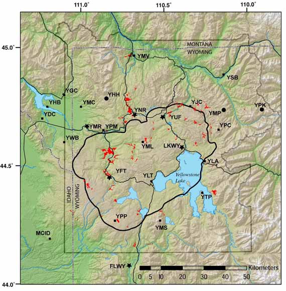
This graphic shows the seismic network of Yellowstone National Park. Small black squares and associated letter codes are one-component stations, large dots are three-component stations, and stars are broadband stations. The FLWY station is maintained by the USGS/ANSS. Thick black line is the boundary of the Yellowstone Caldera. Thin black lines are roads. Gray outline is park boundary. Red regions are thermal areas.
To provide Yellowstone National Park (YNP) and its surrounding communities with a modern, comprehensive system for volcano and earthquake monitoring, the Yellowstone Volcano Observatory (YVO) has developed a monitoring plan for the period 2006-2015. Such a plan is needed so that YVO can provide timely information during seismic, volcanic, and hydrothermal crises and can anticipate hazardous events before they occur. The monitoring network will also provide high-quality data for scientific study and interpretation of one of the largest active volcanic systems in the world. Among the needs of the observatory are to upgrade its seismograph network to modern standards and to add five new seismograph stations in areas of the park that currently lack adequate station density. In cooperation with the National Science Foundation (NSF) and its Plate Boundary Observatory Program (PBO), YVO seeks to install five borehole strainmeters and two tiltmeters to measure crustal movements. The boreholes would be located in developed areas close to existing infrastructure and away from sensitive geothermal features. In conjunction with the park's geothermal monitoring program, installation of new stream gages, and gas-measuring instruments will allow YVO to compare geophysical phenomena, such as earthquakes and ground motions, to hydrothermal events, such as anomalous water and gas discharge. In addition, YVO seeks to characterize the behavior of geyser basins, both to detect any precursors to hydrothermal explosions and to monitor earthquakes related to fluid movements that are difficult to detect with the current monitoring system. Finally, a monitoring network consists not solely of instruments, but requires also a secure system for real-time transmission of data. The current telemetry system is vulnerable to failures that could jeopardize data transmission out of Yellowstone. Future advances in monitoring technologies must be accompanied by improvements in the infrastructure for data transmission. Overall, our strategy is to (1) maximize our ability to provide rapid assessments of changing conditions to ensure public safety, (2) minimize environmental and visual impact, and (3) install instrumentation in developed areas.
Download this report as a 17-page PDF file (sir2006-5276.pdf; 3.7 MB)
For questions about the content of this report, contact Jake Lowenstern
Download a copy of the latest version of Adobe Reader for free.
|
Help |
PDF help |
Publications main page |
| Western Scientific Investigations Reports |
| Geology |
Yellowstone Volcano Observatory
|

![]() U.S. Department of the Interior | U.S. Geological Survey
U.S. Department of the Interior | U.S. Geological Survey
URL: https://pubs.usgs.gov/sir/2006/5276/
Page Contact Information: Michael Diggles
Page Last Modified: February 19, 2008