Scientific Investigations Report 2007–5009
U.S. GEOLOGICAL SURVEY
Scientific Investigations Report 2007–5009
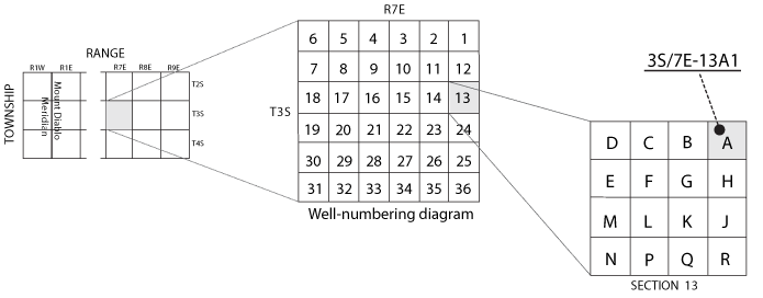
Wells are identified and numbered according to their location in the rectangular system for the subdivision of public lands. Identification consists of the township number, north or south; the range number, east or west; and the section number. Each section is divided into sixteen 40-acre tracts lettered consecutively (except I and O), beginning with “A” in the northeast corner of the section and progressing in a sinusoidal manner to “R” in the southeast corner. Within the 40-acre tract, wells are sequentially numbered in the order they are inventoried. The final letter refers to the base line and meridian. In California, there are three base lines and meridians; Humboldt (H), Mount Diablo (M), and San Bernardino (S). All wells in the study area are referenced to the Mount Diablo base line and meridian. Well numbers consist of 15 characters and follow the format 003S007E13A001. In this report, well numbers are abbreviated and written 3S/7E-13A1. The following diagram shows how the number for well 3S/7E-13A1 is derived.

![]() U.S.
Department of the Interior | U.S. Geological Survey
U.S.
Department of the Interior | U.S. Geological Survey
Persistent URL: https://pubs.water.usgs.gov/sir20075009
Page Contact Information: Publications Team
Page Last Modified: Thursday, 01-Dec-2016 19:40:24 EST
