Scientific Investigations Report 2007-5010
Prepared in cooperation with
South Florida Water Management District
as part of the Comprehensive Everglades Restoration Plan
CONTENTSAbstract1 - Introduction 1.1 - Purpose and Scope 1.2 - Description of Study Area 1.3 - Acknowledgments 2 - Development of the FTLOADDS Model Code 2.1 - Version 2.1 of the FTLOADDS Code 2.2 - Version 2.2 of the FTLOADDS Code 3 - Application of FTLOADDS to TIME 3.1 - Simulation Period 3.2 - Model Grid 3.3 - Model Input 3.4 - Freshwater Flux Output at the TIME Application Boundary 3.5 - Model Initialization 3.6 - Initial Model Calibration 3.7 - Model Sensitivity Studies 3.8 - Final Model Calibration Run 157 3.9 - Future Uses of TIME Application 4 - Summary 5 - References Cited Appendix 1: SICS Application Scenarios Appendix 2: Parameters for FTLOADDS Input Files |
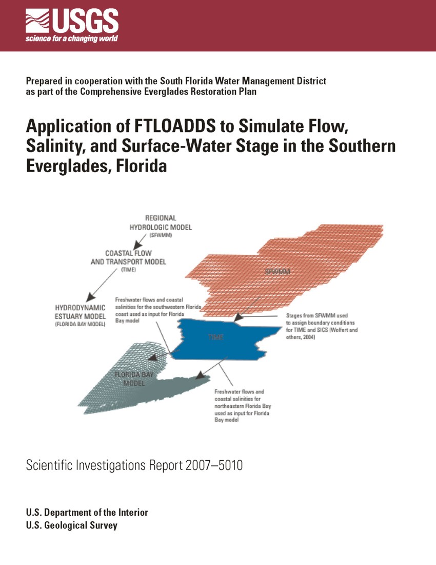
The Comprehensive Everglades Restoration Plan requires numerical modeling to achieve a sufficient understanding of coastal freshwater flows, nutrient sources, and the evaluation of management alternatives to restore the ecosystem of southern Florida. Numerical models include a regional water-management model to represent restoration changes to the hydrology of southern Florida and a hydrodynamic model to represent the southern and western offshore waters. The coastal interface between these two systems, however, has complex surface-water/ground-water and freshwater/saltwater interactions and requires a specialized modeling effort. The Flow and Transport in a Linked Overland/Aquifer Density Dependent System (FTLOADDS) code was developed to represent connected surface- and ground-water systems with variable-density flow.
The first use of FTLOADDS is the Southern Inland and Coastal Systems (SICS) application to the southeastern part of the Everglades/Florida Bay coastal region. The need to (1) expand the domain of the numerical modeling into most of Everglades National Park and the western coastal area, and (2) better represent the effect of water-delivery control structures, led to the application of the FTLOADDS code to the Tides and Inflows in the Mangroves of the Everglades (TIME) domain. This application allows the model to address a broader range of hydrologic issues and incorporate new code modifications. The surface-water hydrology is of primary interest to water managers, and is the main focus of this study. The coupling to ground water, however, was necessary to accurately represent leakage exchange between the surface water and ground water, which transfers substantial volumes of water and salt.
Initial calibration and analysis of the TIME application produced simulated results that compare well statistically with field-measured values. A comparison of TIME simulation results to previous SICS results shows improved capabilities, particularly in the representation of coastal flows. This improvement most likely is due to a more stable numerical representation of the coastal creek outlets.
Sensitivity analyses were performed by varying frictional resistance, leakage, barriers to flow, and topography. Changing frictional resistance values in inland areas was shown to improve water-level representation locally, but to have a negligible effect on area-wide values. These changes have only local effects and are not physically based (as are the unchanged values), and thus have limited validity. Sensitivity tests indicate that the overall accuracy of the simulation is diminished if leakage between surface water and ground water is not simulated. The inclusion of a major road as a complete barrier to surface-water flow influenced the local distribution and timing of flow; however, the changes in total flow and individual creekflows were negligible. The model land-surface altitude was lowered by 0.1 meter to determine the sensitivity to topographic variation. This topographic sensitivity test produced mixed results in matching field data. Overall, the representation of stage did not improve definitively.
A final calibration utilized the results of the sensitivity analysis to refine the TIME application. To accomplish this calibration, the friction coefficient was reduced at the northern boundary inflow and increased in the southwestern corner of the model, the evapotranspiration function was varied, additional data were used for the ground-water head boundary along the southeast, and the frictional resistance of the primary coastal creek outlet was increased. The calibration improved the match between measured and simulated total flows to Florida Bay and coastal salinities. Agreement also was improved at most of the water-level sites throughout the model domain.
Wang, J.D., Swain, E.D., Wolfert, M.A., Langevin, C.D., James, D.E., and Telis, P.A., 2007, Application of FTLOADDS to Simulate Flow, Salinity, and Surface-Water Stage in the Southern Everglades, Florida: U.S. Geological Survey Scientific Investigations Report 20075010, 112 p.
U.S. Department of the Interior
U.S. Geological Survey
Florida Integrated Science Center
3110 SW 9th Avenue
Ft. Lauderdale, FL 33315
954-377-5900
Eric D. Swain edswain@usgs.gov
| Accessibility FOIA Privacy Policies and Notices | U.S. Department of the Interior, U.S. Geological Survey
Persistent URL: https://pubs.usgs.gov/sir/2007/5010 Page Contact Information: USGS Publishing Network Page Last Modified: Thursday, 01-Dec-2016 19:53:39 EST |
 |