Scientific Investigations Report 2007–5028
Report PDF (1.3 MB)
Plate PDF (526 kB)
|
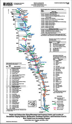
AbstractThe U.S. Geological Survey, in cooperation with Colorado Springs Utilities, the Colorado Water Conservation Board, and the El Paso County Water Authority, began a study in 2004 with the following objectives: (1) Apply a stream-aquifer model to Monument Creek, (2) use the results of the modeling to develop a transit-loss accounting program for Monument Creek, (3) revise an existing accounting program for Fountain Creek to easily incorporate ongoing and future changes in management of return flows of reusable water, and (4) integrate the two accounting programs into a single program and develop a Web-based interface to the integrated program that incorporates simple and reliable data entry that is automated to the fullest extent possible. This report describes the results of completing objectives (2), (3), and (4) of that study. The accounting program for Monument Creek was developed first by (1) using the existing accounting program for Fountain Creek as a prototype, (2) incorporating the transit-loss results from a stream-aquifer modeling analysis of Monument Creek, and (3) developing new output reports. The capabilities of the existing accounting program for Fountain Creek then were incorporated into the program for Monument Creek and the output reports were expanded to include Fountain Creek. A Web-based interface to the new transit-loss accounting program then was developed that provided automated data entry. An integrated system of 34 nodes and 33 subreaches was integrated by combining the independent node and subreach systems used in the previously completed stream-aquifer modeling studies for the Monument and Fountain Creek reaches. Important operational criteria that were implemented in the new transit-loss accounting program for Monument and Fountain Creeks included the following: (1) Retain all the reusable water-management capabilities incorporated into the existing accounting program for Fountain Creek; (2) enable daily accounting and transit-loss computations for a variable number of reusable return flows discharged into Monument Creek at selected locations; (3) enable diversion of all or a part of a reusable return flow at any selected node for purposes of storage in off-stream reservoirs or other similar types of reusable water management; (4) and provide flexibility in the accounting program to change the number of return-flow entities, the locations at which the return flows discharge into Monument or Fountain Creeks, or the locations to which the return flows are delivered. The primary component of the Web-based interface is a data-entry form that displays data stored in the accounting program input file; the data-entry form allows for entry and modification of new data, which then is rewritten to the input file. When the data-entry form is displayed, up-to-date discharge data for each station are automatically computed and entered on the data-entry form. Data for native return flows, reusable return flows, reusable return flow diversions, and native diversions also are entered automatically or manually, if needed. In computing the estimated quantities of reusable return flow and the associated transit losses, the accounting program uses two sets of computations. The first set of computations is made between any two adjacent streamflow-gaging stations (termed “stream-segment loop”); the primary purpose of the stream-segment loop is to estimate the loss or gain in native discharge between the two adjacent streamflow-gaging stations. The second set of computations is made between any two adjacent nodes (termed “subreach loop”); the actual transit-loss computations are made in the subreach loop, using the result from the stream-segment loop. The stream-segment loop is completed for a stream segment, and then the subreach loop is completed for each subreach within the segment. When the subreach loop is completed for all subreaches within a stream segment, the stream-segment loop is initiated for the next stream segment, followed by initiating the subreach loop again; the process continues until transit-loss computations are completed downstream through all subreaches. An iterative process for the two loops is used to ensure that computed downstream reusable return flow and assumed downstream reusable return flow are within a determined criterion. |
Kuhn, Gerhard, Krammes, G.S., and Beal, V.J., 2007, Description and user manual for a Web-based interface to a transit-loss accounting program for Monument and Fountain Creeks, El Paso and Pueblo Counties, Colorado: U.S. Geological Survey Scientific Investigations Report 2007–5028, 36 p.
Abstract
Introduction
Purpose and Scope
Acknowledgments
Development of New Transit-Loss Accounting Program
Integrated System of Nodes and Subreaches
Overview of Operational Methods for Existing Accounting Program
Operational Requirements for New Accounting Program
Data-Entry Design for New Accounting Program
User Manual for Web-Based Interface to Transit-Loss Accounting Program
Menu-Page Features
Data-Entry Form
Ditch Accounts Data-Entry Form
Development of Automated Data-Entry Methods
Program Output Report
Operational Methods for New Transit-Loss Accounting Program
New Method for Reusable Return-Flow Accounting
Data Characteristics
Program Computations
Assumptions Used in the Computations
Stream-Segment Computations
Subreach Computations
Comparison of Results from Existing and New Transit-Loss Accounting Programs
Summary
References Cited
Appendixes
| Document Accessibility: Adobe Systems Incorporated has information about PDFs and the visually impaired. This information provides tools to help make PDF files accessible. These tools convert Adobe PDF documents into HTML or ASCII text, which then can be read by a number of common screen-reading programs that synthesize text as audible speech. In addition, an accessible version of Acrobat Reader 7.0 for Windows (English only), which contains support for screen readers, is available. These tools and the accessible reader may be obtained free from Adobe at Adobe Access. |

![]() U.S. Department of the Interior | U.S. Geological Survey
U.S. Department of the Interior | U.S. Geological Survey
URL: http://pubsdata.usgs.gov/pubs/sir/2007/5028/index.html
Questions or Assistance: Contact USGS
Last modified: Thursday, 01-Dec-2016 19:48:38 EST