Scientific Investigations Report 2007–5044
U.S. GEOLOGICAL SURVEY
Scientific Investigations Report 2007–5044
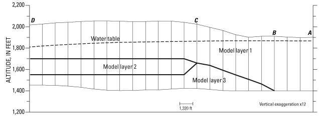
Figure 34. Vertical section A-B-C-D showing how model layers represent the dividing of the aquifer from a single hydrogeologic unit into an upper and lower unit separated by a clay layer, Spokane Valley-Rathdrum Prairie aquifer, Washington and Idaho.

![]() U.S.
Department of the Interior | U.S. Geological
Survey
U.S.
Department of the Interior | U.S. Geological
Survey
Persistent URL: https://pubs.water.usgs.gov/sir20075044
Page Contact Information: Publications Team
Page Last Modified: Thursday, 01-Dec-2016 19:43:40 EST
