Scientific Investigations Report 2007–5095
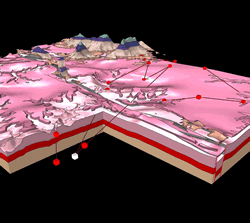 
Abstract Understanding ground-water flow in a karst aquifer benefits from a detailed conception of the three-dimensional (3D) geologic framework. Traditional two-dimensional products, such as geologic maps, cross-sections, and structure contour maps, convey a mental picture of the area but a stronger conceptualization can be achieved by constructing a digital 3D representation of the stratigraphic and structural geologic features. In this study, a 3D geologic model was created to better understand a karst aquifer system in the Buffalo National River watershed in northern Arkansas. The model was constructed based on data obtained from recent, detailed geologic mapping for the Hasty and Western Grove 7.5-minute quadrangles. The resulting model represents 11 stratigraphic zones of Ordovician, Mississippian, and Pennsylvanian age. As a result of the highly dissected topography, stratigraphic and structural control from geologic contacts and interpreted structure contours were sufficient for effectively modeling the faults and folds in the model area. Combined with recent dye-tracing studies, the 3D framework model is useful for visualizing the various geologic features and for analyzing the potential control they exert on the ground-water flow regime. Evaluation of the model, by comparison to published maps and cross-sections, indicates that the model accurately reproduces both the surface geology and subsurface geologic features of the area. 1U.S. Geological Survey, Denver, CO 80225 |
Version 1.0 Posted September 2007
Refer to the Readme and Metadata files for detailed information.
|
Turner, K.J., Hudson, M.R., Murray, K.E., and Mott, D.N., 2007, Three-Dimensional Geologic Framework Model for a Karst Aquifer System, Hasty and Western Grove Quadrangles, Northern Arkansas: U.S. Geological Survey Scientific Investigations Report 2007–5095, 12 p.

![]() U.S. Department of the Interior | U.S. Geological Survey
U.S. Department of the Interior | U.S. Geological Survey
URL: http://pubsdata.usgs.gov/pubs/sir/2007/5095/index.html
Questions or Assistance: Contact USGS
Last modified: Thursday, 01-Dec-2016 19:47:29 EST
