Scientific Investigations Report 2007–5157
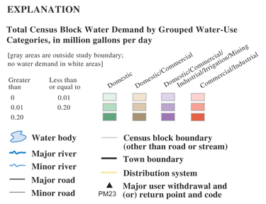
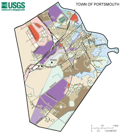
The map of water demand shows the geographic characteristics of water demand in each town. The map indicates the range of the amount of water demand by different groupings of users. Water demand is summarized by census block with colors representing different combinations of water-use categories:
The amount of water demand is represented by
The general locations of community water distribution systems are represented by thick yellow lines with roads drawn on top. Points of withdrawal or return flow for registered users and community water and wastewater systems are represented by black triangles with a code associated with the user. The list of codes is available from the New Hampshire Department of Environmental Services (NHDES). The map for Portsmouth, for example, shows several census blocks with more than 0.10 Mgal/d of water demand by non-domestic users (dark red) in the northwest and northeast parts of the town. Some census blocks are shown with more than 0.10 Mgal/d of water demand by non-domestic and domestic users (dark purple), in the northern, central, and southern parts of Portsmouth. Water demand by a mix of domestic and commercial users (browns) dominates the city, with limited areas of domestic users only (greens). Total water demand is not divided by area, so blocks with larger areas might have a higher total water demand, but not a higher demand per square mile.
|

![]() U.S. Department of the Interior |
U.S. Geological Survey
U.S. Department of the Interior |
U.S. Geological Survey
URL: https://pubs.usgs.gov/sir/2007/5157/maps.htm
Page Contact Information: Laura Hayes, Marilee Horn
Page Last Modified: 25-March-08, 16:00:00 EDT
