Scientific Investigations Report 2007–5186
U.S. GEOLOGICAL SURVEY
Scientific Investigations Report 2007–5186
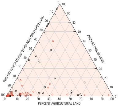
Figure 23. Land use for the 91 catchments with delineated drainage areas for the Columbia River and Puget Sound Basins, calendar year 2000. Trend sites are designated with red circles, whereas all circled sites were used for load estimates.

![]() U.S. Department of the Interior | U.S. Geological Survey
U.S. Department of the Interior | U.S. Geological Survey
URL: https://pubs.usgs.gov/sir/2007/5186
Page Contact Information: Publications Team
Page Last Modified: Thursday, 01-Dec-2016 19:52:25 EST
