Western Earth Surface Processes
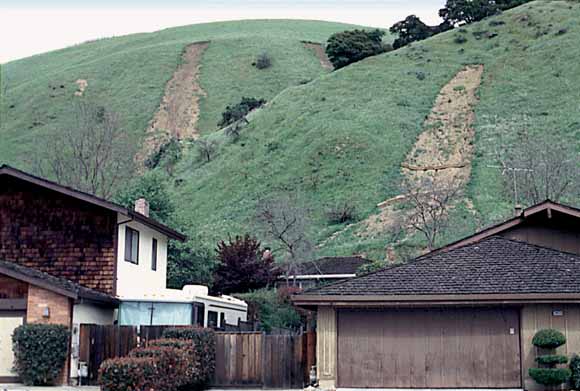
Debris flows on San Francisco Bay region hillsides, triggered by the February 1998 storm. Photograph by J.A. Coe, U.S. Geological Survey.
With the exception of Los Angeles, perhaps no urban area in the United States is more at risk from landsliding, triggered by either precipitation or earthquake, than the San Francisco Bay region of northern California. By January each year, seasonal winter storms usually bring moisture levels of San Francisco Bay region hillsides to the point of saturation, after which additional heavy rainfall may induce landslides of various types and levels of severity. In addition, movement at any time along one of several active faults in the area may generate an earthquake large enough to trigger landslides. The danger to life and property rises each year as local populations continue to expand and more hillsides are graded for development of residential housing and its supporting infrastructure.
The chapters in the text consist of:
The relative hazard for each of several landslide scenarios is presented as a geospatial database. This publication includes ARC/INFO (Environmental Systems Research Institute, http://www.esri.com) version 8.1.2 grids and associated tables and four text files of FGDC-compliant metadata for each grid.
Download text of this paper as a 55-page PDF file (sir2007-5196_text.pdf; 16.4 MB)
Download plate 1 as a 30" x 38" PDF file (plates/sir2007-5196_plate1.pdf; 2.2 MB)
Download plate 2 as a 30" x 38" PDF file (plates/sir2007-5196_plate2.pdf; 2.6 MB)
Download plate 3 as a 37" x 44" PDF file (plates/sir2007-5196_plate3.pdf; 2.4 MB)
Download plate 4 as a 37" x 44" PDF file (plates/sir2007-5196_plate4.pdf; 1.2 MB)
Download the readme file as an ASCII .txt document (sir2007-5196_readme.txt; 8 kB)
Go to the metadata folder (metadata; 4 items that total 104 kB)
Download the data package for the maps. It is a gzip-TAR file containing four grids and the associated INFO directory (sir2007-5196.tgz; 12.9-MB compressed file that expands to a 114-MB folder)
For questions about the content of this report, contact Dick Pike or Russ Graymer.
Suggested citation and version history
Download a free copy of the latest version of Adobe Reader.
|
Help |
PDF help |
Publications main page |
| Western Scientific Investigations Reports |
| Geologic Division | Western Earth Surface Processes |

![]() U.S. Department of the Interior | U.S. Geological Survey
U.S. Department of the Interior | U.S. Geological Survey
URL: https://pubs.usgs.gov/sir/2007/5196/
Page Contact Information: Michael Diggles
Page Created: July 22, 2008
Page Last Modified: July 25, 2008
