Scientific Investigations Report 2007–5237
U.S. GEOLOGICAL SURVEY
Scientific Investigations Report 2007–5237
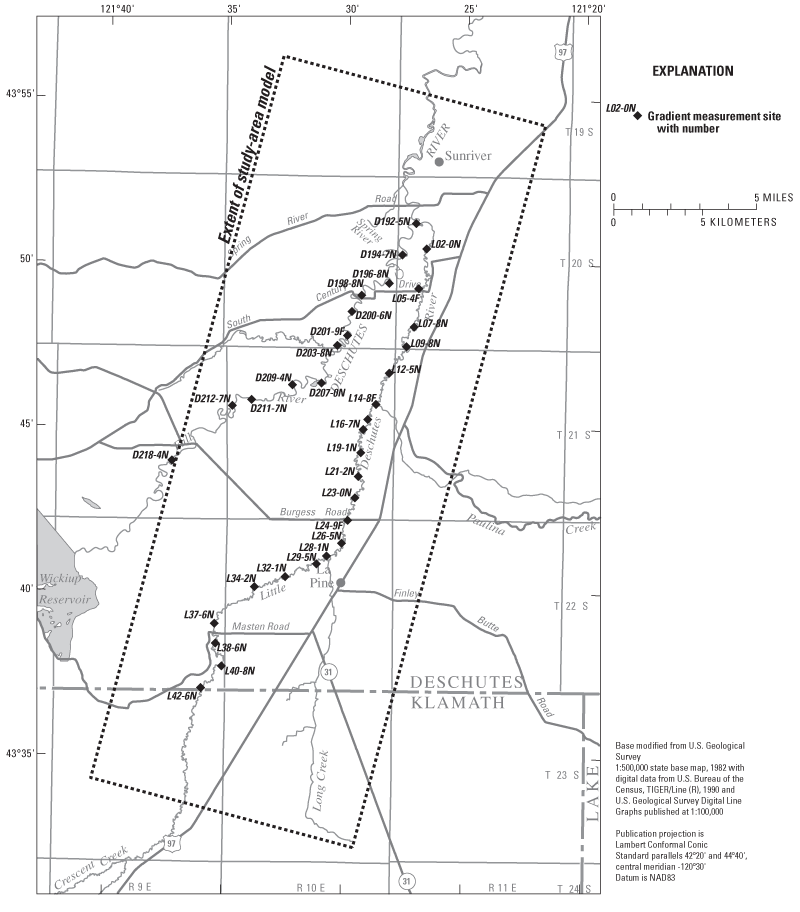
Figure A1. Locations of vertical head gradient measurement sites in the La Pine, Oregon, study area.
Table A1. Vertical hydraulic head gradient data from measurements made on the Deschutes and Little Deschutes Rivers, in the La Pine, Oregon, study area, October 23– November 4, 2000.
[Nutrients: Yes, ground-water samples collected and anlayzed for nitrogen by Oregon Department of Environmental Quality, using methods described in Hinkle and others, 2007a. Depth: average stream depth at time of measurement. Width, stream width at time of measurement. HW_depth: average depth at high water mark. HW_width: width at high water. SURFACE_LITH: streambed lithology at surface (see lithology codes). UNDERLYING_LITH: streambed lithology 0.5–1.0 foot below surface. MEAN_GRADIENT: vertical hydraulic gradient between stream and sediments 1.0 foot below steambed surface. Gradients are in units of foot per foot, positive upward. Lithology codes: CL, clay; CS, claystone; GC, gravel, coarse; GF, gravel, fine; GR, gravel, medium; ML, silt; SA, sand, medium; SC, sand, coarse; SF, sand, fine; TU, tuff. Abbreviation: ft, foot. Symbol: >, greater than]
| Site identification No. | Latitude | Longitude | Date | Nutrients | Depth (ft) | Width (ft) | HW_depth (ft) | HW_width (ft) | SURFACE_LITH | UNDERLYING_LITH | MEAN_GRADIENT | Remarks |
|---|---|---|---|---|---|---|---|---|---|---|---|---|
| Deschutes River | ||||||||||||
| D192-5N | 43.854.04 | -121.453.41 | 10-26-00 | 3.0 | 120 | 5.0 | 150 | GFSA | 0.020 | |||
| D194-7N | 43.838.06 | -121.462.77 | 10-26-00 | 4.0 | 120 | 6.0 | 150 | SASF | SCGF | .040 | ||
| D196-8N | 43.823.58 | -121.471.84 | 10-26-00 | 4.0 | 100 | 7.0 | 140 | SAGR | SA | .045 | ||
| D198-8N | 43.817.41 | -121.491.07 | 10-26-00 | 2.0 | 195 | 4.0 | 235 | SCSA | SCGF | .025 | ||
| D200-6N | 43.809.13 | -121.497.73 | 11-04-00 | 3.0 | 100 | 5.0 | 120 | GFGR | .050 | Hard (tuff?) below 1 ft. | ||
| D201-9F | 43.796.98 | -121.500.63 | 11-04-00 | 3.0 | 60 | 5.0 | 100 | SCSA | GF | .010 | ||
| D203-8N | 43.791.82 | -121.507.65 | 11-04-00 | 4.0 | 80 | 6.0 | 100 | SA | .025 | |||
| D207-0N | 43.772.66 | -121.518.44 | 11-04-00 | 2.0 | 110 | 5.0 | 150 | GRSA | GCML | .060 | ||
| D209-4N | 43.771.66 | -121.538.71 | 10-26-00 | 2.5 | 90 | 4.0 | 130 | GCTU | TU | .010 | Gravel on bedrock. | |
| D211-7N | 43.763.98 | -121.567.13 | 10-25-00 | 2.0 | 105 | 3.5 | 125 | GCTU | GRSA | .031 | Gravel on bedrock (0.8 ft penetration), iron rich. | |
| D212-7N | 43.760.80 | -121.580.55 | 10-25-00 | 2.0 | 106 | 4.0 | 120 | GCTU | TU | .035 | Gravel/cobbles on bedrock. | |
| D218-4N | 43.732.73 | -121.622.24 | 10-24-00 | 2.5 | 128 | 4.5 | 140 | GCTU | TU | .045 | gravel/cobbles on bedrock. | |
| Little Deschutes River | ||||||||||||
| L02-0N | 43.841.25 | -121.445.92 | 10-27-00 | 3.0 | 46 | 6.0 | 60 | SASC | GR | .033 | Blocks of tuff on rt bank. | |
| L05-4F | 43.820.99 | -121.451.21 | 10-27-00 | 3.0 | 42 | 5.0 | 50 | SC | SAML | .028 | ||
| L07-8N | 43.801.55 | -121.454.10 | 10-27-00 | Yes | 2.5 | 42 | 4.5 | 46 | SC | MLGR | .010 | |
| L09-8N | 43.791.56 | -121.459.23 | 10-27-00 | Yes | 2.0 | 44 | 4.5 | 52 | SC | SFML | .020 | Depths 1, 2, 3 ft. |
| L12-5N | 43.778.04 | -121.471.14 | 10-27-00 | Yes | 1.5 | 47 | 3.5 | 57 | SCML | MLSF | .035 | Depths 1, 2, 3 ft. |
| L14-8F | 43.762.16 | -121.480.19 | 10-27-00 | 2.0 | 35 | 4.0 | 55 | GFCS | SAML | .050 | Three measurements at 1-ft depth. | |
| L16-7N | 43.749.33 | -121.488.87 | 10-26-00 | Yes | 2.0 | 31 | 3.0 | 50 | SAGR | SCML | .015 | |
| L19-1N | 43.737.57 | -121.490.42 | 10-26-00 | Yes | 2.0 | 40 | 3.5 | 50 | SCGF | SFML | .015 | Measurements at 1, 2 ft. |
| L21-2N | 43.725.54 | -121.491.91 | 10-26-00 | Yes | 2.0 | 40 | 3.0 | 45 | SC | CSML | .010 | No yield at 1 ft, gas; this is 2 ft measurement. |
| L23-0N | 43.714.71 | -121.494.13 | 10-26-00 | 2.0 | 32 | 4.0 | 36 | SASC | SFML | .020 | ||
| L24-9F | 43.703.25 | -121.499.02 | 10-23-00 | Yes | 1.5 | 57 | 3.5 | 77 | GFSA | .017 | 15 measurements, 3 per depth (1–3 ft). | |
| L26-5N | 43.691.59 | -121.503.07 | 10-25-00 | 2.0 | 37 | 4.0 | 47 | SCGF | MLSA | .010 | Measurements at 1, 2 ft. | |
| L28-1N | 43.685.07 | -121.513.44 | 10-25-00 | 2.5 | 36 | 4.0 | 45 | SCGF | MLSF | .000 | Measurements at 1, 2 ft. | |
| L29-5N | 43.680.99 | -121.520.43 | 10-25-00 | 2.0 | 35 | 3.5 | 40 | SCGF | CL | -.003 | Clay at >1 ft, no yield at 2 ft. | |
| L32-1N | 43.674.35 | -121.542.20 | 10-25-00 | 2.0 | 40 | 3.5 | 46 | SCGR | ML | .010 | ||
| L34-2N | 43.669.07 | -121.563.59 | 10-25-00 | 2.0 | 28 | 3.0 | 30 | GF | CL | .025 | Clay >1 ft, no yield at 2 ft. | |
| L37-6N | 43.650.22 | -121.591.21 | 10-24-00 | 1.5 | 47 | 3.5 | 52 | GR | CL | .075 | Clay >2 ft, no yield at 3 ft. | |
| L38-6N | 43.640.24 | -121.590.31 | 10-24-00 | 2.0 | 38 | 3.5 | 40 | GRCS | ML | .025 | Silt >1 ft, no yield at 2 ft. | |
| L40-8N | 43.628.71 | -121.585.89 | 10-24-00 | 2.0 | 50 | 4.0 | 55 | GFSA | SAML | .010 | Silt >1 ft, no yield at 2 ft. | |
| L42-6N | 43.617.56 | -121.600.17 | 10-24-00 | 1.5 | 40 | 3.0 | 50 | SCGR | ML | .010 | Silt >1ft, no yield at 2 ft. | |

![]() U.S. Department of the Interior | U.S. Geological Survey
U.S. Department of the Interior | U.S. Geological Survey
URL: https://pubs.usgs.gov/sir/2007/5237
Page Contact Information: Publications Team
Page Last Modified: Thursday, 01-Dec-2016 19:54:19 EST
