Scientific Investigations Report 2007–5251
U.S. GEOLOGICAL SURVEY
Scientific Investigations Report 2007–5251
Version 2.0, June 2013
| Multiply | By | To obtain |
|---|---|---|
| centimeter (cm) | 0.3937 | inch (in) |
| millimeter (mm) | 0.03937 | inch (in) |
| meter (m) | 3.281 | foot (ft) |
| kilometer (km) | 0.6214 | mile (mi) |
| square kilometer (km2) | 0.3861 | square mile (mi2) |
| meter per day (m/d) | 3.281 | foot per day (ft/d) |
| meter per year (m/yr) | 3.281 | foot per year (ft/yr) |
| millimeter per day (mm/d) | 0.003281 | foot per day (ft/d) |
| millimeter per month (mm/mo) | 0.003281 | foot per month (ft/mo) |
| millimeter per year (mm/yr) | 0.03937 | inch per year (in/yr) |
| kilometer per hour (km/h) | 0.6214 | mile per hour (mi/h) |
Temperature in degrees Celsius (°C) may be converted to degrees Fahrenheit (°F) as follows:
°F=(1.8×°C)+32
Vertical displacements determined by InSAR and coordinates determined by Global Positioning System (GPS) surveying generally are reported in metric units. The industry standard for GPS usage is that field measurements and subsequent computations, including standard error determinations, are done in the metric system. The use of dual units in this report is intended to facilitate application of the data by maintaining the integrity of the original units of measurement for GPS surveying.
Sea level: In this report, “sea level” refers to the National Geodetic Vertical Datum of 1929 (NGVD of 1929)—a geodetic datum derived from a general adjustment of the first-order level nets of both the United Sates and Canada, formerly called Sea Level Datum of 1929.
Ellipsoid heights: In this report, Global Positioning System (GPS) measurements of horizontal coordinates and ellipsoid heights are based on the North American Datum of 1983 (NAD83).
| Caltrans | California Department of Transportation |
| CGPS | Continuous Global Positioning System |
| CVWD | Coachella Valley Water District |
| DEM | digital elevation model |
| ESA | European Space Agency |
| GPS | Global Positioning System |
| IGS | International GPS Service |
| InSAR | Interferometric Synthetic Aperture Radar |
| NGS | National Geodetic Survey |
| SAR | Synthetic Aperture Radar |
| SCIGN | Southern California Integrated GPS Network |
| SOPAC | Scripps Orbit and Permanent Array Center |
| UNAVCO | University NAVSTAR (Navigation Signal Timing and Ranging) Consortium |
| USGS | United States Geological Survey |

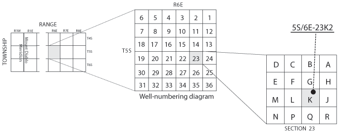
Wells are identified and numbered according to their location in the rectangular system for the subdivision of public lands. Identification consists of the township number, north or south; the range number, east or west; and the section number. Each section is divided into sixteen 40-acre tracts lettered consecutively (except I and O), beginning with "A" in the northeast corner of the section and progressing in a sinusoidal manner to "R" in the southeast corner. Within the 40-acre tract, wells are sequentially numbered in the order they are inventoried. The final letter refers to the base line and meridian. In California, there are three base lines and meridians; Humboldt (H), Mount Diablo (M), and San Bernardino (S). All wells in the study area are referenced to the San Bernardino base line and meridian (S) Well numbers consist of 15 characters and follow the format 005S006E23K002S. In this report, well numbers are abbreviated and written 5S/6E-23K2. Wells in the same township and range are referred to only by their section designation, 23K2. The following diagram shows how the number for well 5S/6E-23K2 is derived.