Coastal and Marine Geology
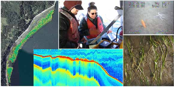
Seagrass at two sites in northern Puget Sound, Possession Point and nearby Browns Bay, was mapped using both a single-beam sonar and underwater video camera. The acoustic and underwater video data were compared to evaluate the accuracy of acoustic estimates of seagrass cover. The accuracy of the acoustic method was calculated for three classifications of seagrass observed in underwater video: bare (no seagrass), patchy seagrass, and continuous seagrass. Acoustic and underwater video methods agreed in 92 percent and 74 percent of observations made in bare and continuous areas, respectively. However, in patchy seagrass, the agreement between acoustic and underwater video was poor (43 percent). The poor agreement between the two methods in areas with patchy seagrass is likely because the two instruments were not precisely colocated.
The distribution of seagrass at the two sites differed both in overall percent vegetated and in the distribution of percent cover versus depth. On the basis of acoustic data, seagrass inhabited 0.29 km2 (19 percent of total area) at Possession Point and 0.043 km2 (5 percent of total area) at the Browns Bay study site. The depth distribution at the two sites was markedly different. Whereas the majority of seagrass at Possession Point occurred between -0.5 and -1.5 m MLLW, most seagrass at Browns Bay occurred at a greater depth, between -2.25 and -3.5 m MLLW. Further investigation of the anthropogenic and natural factors causing these differences in distribution is needed.
Download this report as a 54-page PDF file (sir2008-5009.pdf; 19.3 MB)
For questions about the content of this report, contact Andrew Stevens.
Suggested citation and version history
Download a free copy of the latest version of Adobe Reader.
|
Help |
PDF help |
Publications main page |
| Western Scientific Investigations Reports |
| Geology | Western Coastal and Marine Geology
|

![]() U.S. Department of the Interior | U.S. Geological Survey
U.S. Department of the Interior | U.S. Geological Survey
URL: http://pubs.usgs.gov/sir/2008/5009/
Page Contact Information: Michael Diggles
Page Last Modified: February 8, 2008
