USGS Scientific Investigations Report 2008-5023
<--Return to Contents
KARST MAPPING
By Emily Hollingsworth1, Van Brahana1, Ethan Inlander2, and Michael Slay2
1University of
Arkansas, Ozark Hall113,
Fayetteville,
AR
72701
2The Nature Conservancy of
Arkansas, 675 Lollar Lane,
Fayetteville,
AR
72701
Download PDF [6.9 MB].
Adobe Reader is required to view the report. A free copy of the Adobe Reader may be downloaded from Adobe Systems Incorporated.
Owing to the lack of a single accessible and comprehensive source of information on the global distribution of karst habitats and species, The Nature Conservancy and the University of Arkansas are collaborating on compiling a comprehensive database of karst distribution and biodiversity. This compilation will serve as the preliminary foundation for a digital global karst dataset which will be used to delineate (1) a worldwide map of karst regions, and (2) a geologic and biogeographic framework for initiating karst conservation and planning on a global scale.
Rapid advancements and expanding technologies in both karst science and Geographic Information Systems (GIS) make the timing of this effort optimum. Multiple groups in multiple disciplines are actively working on developing regional and global karst maps, reflecting the growing perception that land use in karst settings is becoming a critical problem. Thus far, the efforts have not generated major redundancy, but the expanding activity suggests that duplication of effort is drawing near, and integration of data-set population and map generation requires communication and coordination to optimize the needs of all karst stakeholders. The importance of characterizing, conserving, and protecting the karst regions of the world cannot be emphasized strongly enough, given the increasing population density of humans that reside in these settings, and the ecosystems that rely on karst environments and karst water to sustain life. This paper summarizes a brief history of the problem, the rationale behind our specific effort, initial progress we have made thus far, and our perceived needs to draw the entire karst community into this long-term, ongoing effort.
Owing to the lack of a single accessible and comprehensive source of information on the global distribution of karst habitats and species, The Nature Conservancy (TNC) and the University of Arkansas (UofA) are collaborating on delineating the worldwide distribution of karst regions of the world (KROW) using current and past karst maps and research. This compilation will serve as the preliminary foundation for a digital global karst dataset which will be used to delineate (1) a worldwide map of karst regions, and (2) a geologic and biogeographic framework for initiating karst conservation and planning on a global scale.
Mapping of karst features has long been an important tool for conservation scientists, but typically mapping has been undertaken at local or regional scale (Johnson and Quinlan, 1994; Weary, 2005; Jianhua et al., 2007). At a continent scale (Culver, 1999; Veni et al., 2001; Epstein et al., 2001; Epstein et al., 2002) or global scale (Kozary et al., 1968; Ford and Williams, 1989; Ford and Williams, 2007), several efforts to integrate all known data into a meaningful map of karst of the world have been undertaken (figure 1). Unfortunately, the variability of existing data and maps, and the disparity of project goals which have led to construction of component maps have made integration of these world maps truly difficult. Highly variable project objectives, funding, map scales, karst understanding, discipline focus, resource needs, data formats, accuracy, precision, completeness, and willingness to share available data have limited efforts to compile such a product.
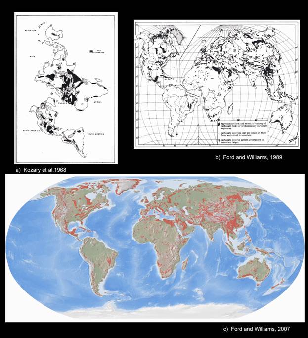
Figure 1. Global occurrence of evaporite and carbonate rock. Figure 1a shows evaporite rocks, most of which (90% of gypsum/anhydrite, 99% of halite) are covered (after Kozary et al., 1968). Figure 1b shows major outcrops of carbonate rocks of the world (after Ford and Williams, 1989). Figure 1c shows the latest revision to major outcrops of carbonate rocks of the world (after Ford and Williams, 2007).
TNC has established the goal to protect 10% of each of the world's major habitat types by 2015. Despite its importance to humans and species, the 2015 goal does not address karst conservation directly. Inasmuch as karst landscapes occur in at least 26 of 29 countries where TNC works, it is their intent to address and protect karst settings through ecoregional planning efforts. Prior to this project, no mapping or analyses were available to steer global karst conservation efforts. This project represents the preliminary effort to delineate these areas, and to establish an interactive ongoing data base that will facilitate the needs of TNC and the karst community for the upcoming decade.
Developing a more complete and accurate set of global karst tools is a necessity. Karst areas are underrepresented in globally protected areas, adding urgency to the need for tools to support conservation. Not only will the creation of a digital karst map and archive allow for ranking and delineation of areas of environmental and ecological sensitivity by blending detailed data based on hydrology, land use, biodiversity, and distribution of endangered and threatened species, it also will serve as the framework for developing a GIS karst toolbox. It is believed that this classification will be of critical importance in directing future efforts in karst management and conservation.
The objectives of this report are twofold: (1) to introduce the rationale and planned methodology of the project, in hopes of eliciting meaningful suggestions for improvement before the project is fully underway; and (2) to share a case study from Australia as an example to illustrate problems, approaches, and work products that have been encountered thus far. The report is preliminary, and reflects an early stage of what is hoped to be a long-term project.
Understanding data base construction and mapping needs of KROW requires a precise definition of the following terms. The first three represent distinct types of subterranean environments, and the last provides limits to the meaning of regions.
Carbonate Karst. Carbonate karst is a terrain with distinctive hydrology and landforms arising from the combination of high rock solubility and well-developed secondary porosity. Ground-water flow velocities typically are much faster here than they are in porous media, contaminant attenuation mechanisms typically are much less effective, and flow tends to be anisotropic and heterogeneous. In most cases, carbonate karst is produced by chemical dissolution by slightly acidic water on a soluble layer of bedrock, notably limestone or dolomite.
Evaporite Karst. Evaporite karst is similar to carbonate karst in that dissolution is the dominant process, but unlike carbonate karst, the very high solubility of evaporite minerals produces highly-mineralized ground water. Environments and ecosystems in evaporite karst would be expected to organisms that are more tolerant of dissolved solutes. The most common of these lithologies include gypsum, anhydrite, and halite
Pseudokarst. Pseudokarst is an environment or setting that resembles karst, but where solution is not a critical formative process to produce cavities, isolated voids or connected passages or tubes. The subsurface environment in these areas is similar in many ways to other types of karst, but because they were formed by processes other than dissolution, ground-water flow, water quality, and environmental factors typically are distinct.
Regions. Regions are areas of land or water that contain a geographically distinct assemblage of ecosystems and natural communities; each may be differentiated by climate, subsurface geology, physiography, hydrology, soil, and vegetation.
Following the approach of Veni et al. (2001), this study has divided KROW into 3 broad categories, carbonate, evaporite, and pseudokarst. Carbonate and evaporite karst were distinguished from one another because of the major differences in water quality created by rock-water interaction in these settings, and pseudokarst was distinguished from the other two because its process of formation is so completely different than normal karst. All methods contribute to similar subsurface ecosystems, but each has the potential to harbor a distinct group of organisms based on unique physical and chemical attributes of lithology and mode of formation.
The distinction between buried and surface karst was determined to be outside the scope of the overarching needs of TNC. Although buried versus surface distinction was included in the map of U.S. karstlands (Veni et al., 2001), and is obviously important to hydrogeologists and others in the karst community, with respect to environments suitable for cave-adapted organisms, it was considered and rejected. The reason for rejection was the fact that almost all subsurface karst environments have the potential to and likely do host microbes, yet fewer than 1% have been studied or sampled. Based on this dearth of data, and the widespread distribution potential, any delineation of deeply buried karst regions would include most of the continental land masses. Such a gross overestimation of karst regions would detract from those surface areas that are truly home to fragile ecosystems.
Data-set architecture and maps are initially being created at the continent scale. Geologic maps of countries exist for most of the world, and where these are accessible in digital format, shape categories for carbonate karst, evaporite karst, and pseudokarst will be captured to generate preliminary continent-scale work maps. Obviously, if karst maps exist for countries, these will be incorporated directly. Where no digital data sets are available, paper maps will be scanned and incorporated into ArcMap 9.2, where they will be transformed into the projection of the referenced base map.
Data-base population will be a continuing and an ongoing process. Within continents, further subdivision by country, state, region, and local area will be undertaken as necessary to adequately delineate the preliminary karst karst boundaries based on the geology maps. The data base will be keyed by a location number to identify attributes, accuracy, and relations between karst features. Specific documentation regarding map scale, display attributes, analysis properties, map use, data source, and relevant annotations will be input as available into the data base, and made accessible through the GIS by pointing at locations on the map.
ArcMap 9.2 and ArcInfo GIS and mapping software have been chosen as the spatial analysis, visualization, and spatial data-management tool for KROW. Digital-processing techniques will be applied for data visualization, enhancement, and interpretation of multiple geodata sets.
Data mining is being undertaken from search engines and internet resources, as well as obvious publications and maps in the public domain. Major data sources include geological surveys, journal articles, speleological and caving societies, unpublished theses, university and karst institutes, conference proceedings, textbooks, engineering reports, water-tracing studies, and caving-club newsletters. These sources are further supplemented with personal contacts across the wide range of science, engineering, and caving--in fact, contact with any groups that focus on some aspect of karst. Selected examples of these groups and their information dissemination outlets include the Karst Interest Group (KIG) of the U.S. Geological Survey (USGS), the Karst Commission of the International Association of Hydrogeologists, the International Union of Speleology, the Karst Information Portal, the National Speleological Society, the Karst Waters Institute, Cave Research Foundation, British Cave Research Association, National Cave and Karst Research Institute, Australasian Cave and Karst Management Association, Canadian Karst Resources and Issues, Slovenian Karst Research Institute, Karstica European Network, UIS Commission on Karst Hydrogeology and Speleogenesis, South American Landscape, Karst and Caves of Madagascar, and IGCP 379 "Karst Processes and the Carbon Cycle".
To show problems, approaches, and work products thus far encountered, we have chosen the case study of distribution of karst in Australia for an example of the methods followed (figure 2). AustraliaThe first step was capture of the referenced base map of Australia , with geographic coordinate system GCS_WGS_1984, added to an active ArcMap window, (figure 2a). The map "Karst of Australia" (Ken G. Grimes, written commun., 2007) was selected to be incorporated into this GIS representation (figure 2b). This map was individually incorporated into an active map where the projection of the specific raster dataset was identified. The raster image was overlain on the base map and the two maps showed comparably different projections. It was necessary to align the two maps where they most closely "fit" together. Using the Georeferencing toolbar, (figure 2c), the raster image was georeferenced to the referenced data by addling control points of known locations on the two maps, (figure 2d). A suitable number of links were required to be added to keep the residual error to a minimum, thereby optimizing accuracy. At this stage, the raster image was able to be transformed into the projection of the base map, and align with the vector dataset, (figure 2e).
Karst features represented on raster images require transformation into individual geographic and georeferenced entities. When applicable, different features, such as surface, subsurface, pseudokarst, and cave locations will be spatially referenced. This will yield data layers of specific karst extents for individual areas.
As additional karst distribution maps are added to the GIS representation, it will be a necessity to determine which of the different karst boundaries to follow when there are discrepancies from map to map. When an inconsistency occurs, each area will be researched to determine the most representative delineation. If possible, local experts will be addressed for site specific input.
A main challenge at a continent scale was integrating and distilling large amounts of different data types, obtained from different sources, compiled from different formats emphasizing different purposes, and developed on different scales. In order to use these data for mapping and interpretation, sources had to be evaluated for fitness of use before point data could be spatially linked to a map. Individual map scales, spatial representations, accuracy, and format required assessment prior to incorporation into a GIS database.
Examples of difficulties to representing continent-scale karst are represented by sites on figure 2e that are shown by small circles and isolated + symbols. Also, the smooth and straight boundaries of the Nullarbor Plain in the south-central part of the continent are typical of generalized boundaries that we feel require revision based on the geologic map. Although these problems are philosophically based, relating to the potential for karst development based on the known lithology, they are likely justified when it comes to characterizing intervening areas that have yet to be studied. The overall objective of protecting karst ecosystems seems to warrant a conservative approach on this first preliminary mapping, and that is the approach we followed.
Yet another problem dealt with the need to identify ecosystems within various areas of karst occurrence. The emphasis thus far has been on distribution mapping, but the database system required flexibility of expansion on the front end of the project to minimize adding fields later, essentially modifying the data base after the project was underway. Intensive planning was critical, and involvement of TNC and karst ecologists was essential to the preliminary phase of the project.
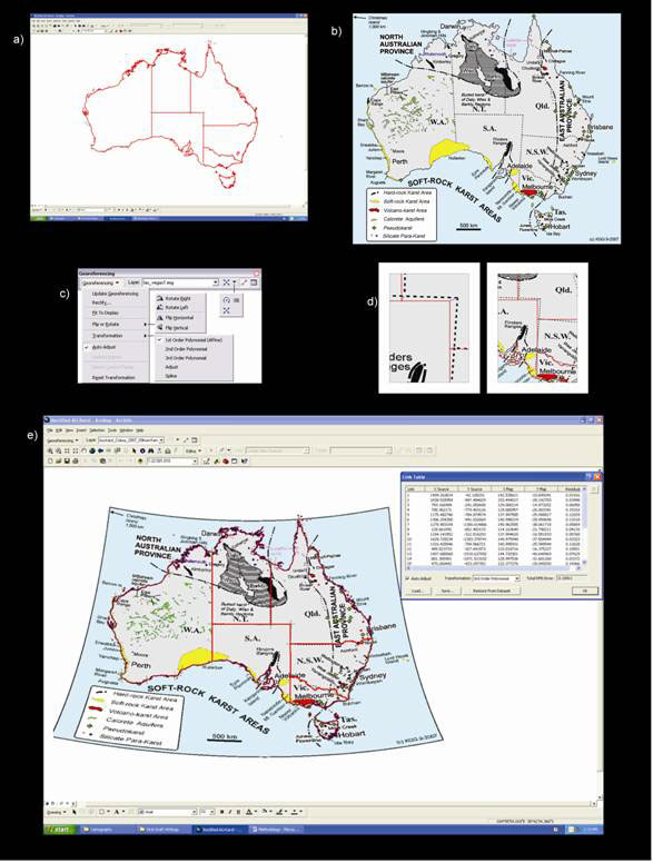
Figure 2a (top left). Image of the referenced base map that depicts the geographical boundaries of Australia. Figure 2b (top right) Raster image of Karst Distribution of Australia by Grimes et al. 2007. Figure 2c (middle left) Standard Georefrencing tool bar associated with ArcMap 9.2. Figure 2d (middle right) is a representation of control points before transformation takes place. Figure 2e (bottom) A view in ArcMap 9.2 of the raster image of karst of Australia aligned with the vector dataset of the geographical boundaries of Australia and the two projected in the GCS_WGS_1984, and the associated data points needed for the transformation.
The creation of the global karst dataset and map described herein should facilitate worldwide communication on karst distribution, and provide the framework for ongoing input and construction of a meaningful GIS. The final products will be the first step toward organizing sources of karst research and references that hopefully will foster collaboration and understanding among karst scientists and conservationists.
The current status regarding the KROW map and archive is promising. The progress of data compilation is progressing rapidly, and although far from complete, it represents a strong first step. The rationale of the methodology allows the database to be built modularly, expanding in a logical progression to accommodate refinements in karst understanding, and new data.
Finally, Karst Regions of the World will help focus conservation where it is most needed, by making useful information accessible to decision makers and conservation practitioners around the world. The map of KROW will be a useful tool for conservation planning across a range of scales, and will help assess conservation efforts and data gaps worldwide.
If you think you have information that could be a valuable component to this effort, please don't hesitate to contact Emily Hollingsworth at ehollin@uark.edu
Carbonates and Evaporites, 1997, (Special issue containing papers presented at a Symposium on Evaporite Karst: Processes, Landforms, Examples, and Impacts), v. 12, no. 1.
Culver, D.C., 1982, Cave life: Evolution and ecology: Cambridge, Mass., Harvard University Press, 223 p.
Culver, D.C., 1999, Terrestrial ecoregions of North America. A Conservation Assessment: in Ricketts, T.H., ed., Ecosystem and Species Diversity Beneath Our Feet: Washington, DC, Island Press, p. 56-60.
Culver, D.C., and White, W.B., 2005, Encyclopedia of Caves: Burlington, MA, Elsevier Academic Press, 654 p.
Davies, W.E., Simpson, J.H., Ohlmacher, G.C., and Kirk, W.S., and Newton, E.G., 1984, Engineering aspects of karst: U.S. Geological Survey, National Atlas, scale 1:7,500,000.
Epstein, J.B., and Orndorff, R.C. and Weary, D.J., 2001, U.S. Geological Survey National Karst map [abs.]: National Speloological Society Convention Progam Guide, p. 87.
Epstein, J.B., Weary, D.J., Orndorff, R.C., Bailey, Z.C., and and Kerbo, R.C., 2002, U.S. Geological Survey Karst Intrest Group Proceedings, Shepherdstown, National Karst Map Project, an Update: U.S. Geological Survey, Report Water-Resources Investigations Report 02-4174, p. 43-44
Finalyson, B., and Hamilton-Smith, E., 2003, Beneath the surface: A natural history of Australian caves: Sydney, Australia , University of New South Wales Press, 199 p..
Florea, L.J., Fratesi, B., and Chaves, T., 2005, The reflection of karst in the online mirror: A survey within scientific databases, 1960-2005. Journal of Cave Karst Studies, v. 69, no.1, p. 229-236.
Ford, D.C., and Williams, P.W., 2007, Karst Hydrology and Geomorphology : London, Wiley Chichester, 2nd ed., 576 p..
Ford, D.C., and Williams, P.W., 1989, Karst Geomorphology and Hydrology: London, Unwin Hyman, 601 p.
Gao, Y., Alexander, E.C., and Tipping, R.G., 2002, The development of a karst feature database for southeastern Minnesota: Journal of Cave and Karst Studies, v. 64 (1), p. 51-57.
Gunn, J., 2004, Encyclopedia of Caves and Karst Science. New York, Fitzroy Dearborn, 902 p.
Hamilton-Smith, E., 1997, The IUCN Guidelines for Cave and Karst Protection: Report Proceedings of the 1997 Karst and Cave Management Symposium, 82 p.
Harmon, R.S., and Wicks, C.M., 2006, Perspectives on karst geomorphology, hydrology, and geochemistry - a tribute volume to Derek C Ford and William B. White:
Geological Society of America , Special Paper 404, 366 p.
Jianhua, C., Daoxian, Z., Cheng, Z., and Zhongcheng, J., 2007, Karst ecosystem of Guangxi zauang Autonomous Region Constrained by Geological Setting: Relationship between carbonate rock exposure and vegetation coverage, in International Confrence on Karst Hydrogeology and Ecosystems, Bowling Green, USA : Bowling Green, KY, Hoffman Environmental Research Institute, p. 15-16.
Johnson, K.S., and Quinlan, J.F., 1994, Regional mapping of karst terranes in order to identify potential environmental problems; Changing karst environments; hydrogeology, geomorphology and conservation; abstracts of papers: Cave and Karst Science, v. 21, p. 15.
Klimchouk, A., Ford, D.C., Palmer, A.N., and Dreybrodt, W., January 2000, Speleogenesis. Evolution of karst aquifers: Huntsville, Alabama, National Speleological Society, 527 p.
Klimchouk, A., 2007, Hypogene Speleogenesis: Hydrogeological and morphogenetic perspective: National Cave and Karst Research Institute Special Paper no.1, v. 1, 106 p.
Kozary, M.T., Dunlap, J.C., and Humphrey, W.E., 1968, Incidence of saline deposits in geologic time. Geological Society of America , Special Paper 88, p. 43-57.
Kranjc, A., Gabrovsek, F., Culver, D.C., and and Sasowsky, I.D., 2007, Time in karst: Charles Town, West Virginia, Karst Waters Institute Special Publication 12, p. 246.
Palmer, A.N., 1991, Origin and morphology of limestone caves: Geological Society of America Bulletin, v. 103, no. 1, p. 1-21.
Spalding, M.D., Fox, H.E., Allen, G.R., Davidson, N., Ferdana, M.F., Halper, B.S., Jorge, M.A., Lomban, A., Lourie, S.A., Martin, K.D., McManus, D., Molnar, J., Recchia, D.A., and and Robertson, J., 2007, Marine Ecoregions of the World: A bioregionalization of coastal and shelf areas: BioScience, v. 57, no.7, p. 573-583.
Taylor, C.J., Nelson, Jr., H.S., Hileman, Gregg, Kaiser, W.P., 2005, Hydrogeologic framework mapping of shallow, conduit-dominated karst--Components of a regional GIS-based approach: in Kuniansky, E.L., ed., U.S. Geological Survey Karst Interest Group Proceedings, Rapid City, South Dakota, September 12-15, 2005: U.S. Geological Survey Scientific Investigations Report 2005-5160, p. 103-113.
Veni, G., April 2002, Revising the karst map of the United States : Journal of Cave and Karst Studies, v. 64 (1), p. 45-50.
Veni, G., DuChene, H., Crawford, N.C., Groves, C.G., Huppert, G.N., Kastning, E.H., Olson, R., and Wheeler, B.J., 2001, Living with Karst- A Fragile Foundation: American Geological Institute Environmental Awareness Series 4, Alexandria, Virginia, 64 p.
Weary, D.J., 2005, An Appalachian regional karst map and progress towards a new National karst map: in Kuniansky, E.L., ed., U.S. Geological Survey Karst Interest Group Proceedings, Rapid City, South Dakota, September 12-15, 2005: U.S. Geological Survey Scientific Investigations Report 2005-5160, p. 93-102.
White, W.B., 1988, Geomorphology and hydrology of karst terrains: New York, Oxford University Press, 464 p.

![]() U.S. Department of the Interior |
U.S. Geological Survey
U.S. Department of the Interior |
U.S. Geological Survey
URL: http://pubsdata.usgs.gov/pubs/sir/2008/5023/06hollings.htm
Page Contact Information: Eve L. Kuniansky
Page Last Modified: Thursday, 10-Jan-2013 15:23:24 EST