Scientific Investigations Report 2008–5059
U.S. GEOLOGICAL SURVEY
Scientific Investigations Report 2008–5059
| Multiply | By | To obtain |
|---|---|---|
| Length | ||
| inch (in.) | 2.54 | centimeter (cm) |
| inch (in.) | 25.4 | millimeter (mm) |
| foot (ft) | 0.3048 | meter (m) |
| mile (mi) | 1.609 | kilometer (km) |
| Area | ||
| acre | 4,047 | square meter (m2) |
| acre | 0.4047 | hectare (ha) |
| acre | 0.4047 | square hectometer (hm2) |
| acre | 0.004047 | square kilometer (km2) |
| section (640 acres or 1 square mile) | 259.0 | square hectometer (hm2) |
| square foot (ft2) | 0.09290 | square meter (m2) |
| square mile (mi2) | 259.0 | hectare (ha) |
| square mile (mi2) | 2.590 | square kilometer (km2) |
| Volume | ||
| cubic foot (ft3) | 28.32 | cubic decimeter (dm3) |
| cubic foot (ft3) | 0.02832 | cubic meter (m3) |
| Flow rate | ||
| foot per second (ft/s) | 0.3048 | meter per second (m/s) |
| cubic foot per second (ft3/s) | 0.02832 | cubic meter per second (m3/s) |
| inch per year (in/yr) | 25.4 | millimeter per year (mm/yr) |
| Multiply | By | To obtain |
|---|---|---|
| Length | ||
| meter (m) | 3.281 | foot (ft) |
| meter (m) | 1.094 | yard (yd) |
Vertical coordinate information is referenced to the North American Vertical Datum of 1988 (NAVD 88).
Sea level, in this report, is used to represent the 0-foot elevation as referenced to NAVD 88. Conversion between NAVD 88 and the commonly used National Geodetic Vertical Datum of 1929 (NGVD 29) varies spatially; however, over most of the study area the following conversion can be used: NGVD 29 = NAVD 88 – 3.5 feet. This conversion generally is accurate within about +/- 0.5 feet. The reader is directed to either the National Geodetic Survey website for VERTCON at http://www.ngs.noaa.gov/TOOLS/Vertcon/vertcon.html or the U.S. Army Corps of Engineers website for Corpscon at http://crunch.tec.army.mil/software/corpscon/corpscon.html for more accurate conversions.
Horizontal coordinate information is referenced to the North American Datum of 1983 (NAD 83).
Conversion between NAD 83 and the commonly used North American Datum of 1927 (NAD 27) varies spatially, and the difference in lateral positions can be greater than 300 feet. For assistance with conversions, the reader is directed to either the National Geodetic Survey website for NADCON at http://www.ngs.noaa.gov/TOOLS/Nadcon/Nadcon.html or the U.S. Army Corps of Engineers website for Corpscon at http://crunch.tec.army.mil/software/corpscon/corpscon.html.
“Elevation,” as used in this report, refers to distance above the vertical datum.
Vertical coordinate information for historical data collected and stored as NGVD 29 has been converted to NAVD 88 for this publication.
Horizontal coordinate information for historical data collected and stored as NAD 27 has been converted to NAD 83 for this publication.
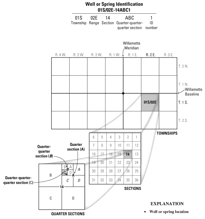
The system used for locating wells, springs, and surface-water sites in this report is based on the Public Land Survey System, a set of rectangular surveys that is used to identify land parcels. The State of Oregon is divided into townships of 36 square miles numbered according to their location relative to the east-west Willamette baseline and a north-south Willamette meridian. The position of a township is given by its north-south “Township” position relative to the baseline and its east-west “Range” position relative to the meridian. Each township is divided into 36 one-square-mile (640-acre) sections numbered from 1 to 36. A well designated as 01S/02E-14ABC1, for example, is located in Township 1 south, Range 2 east, section 14. Letters following the section number correspond to the location within the section; the first letter (A) identifies the quarter section (160 acres); the second letter (B) identifies the quarter-quarter section (40 acres); and the third letter (C) identifies the quarter-quarter-quarter section (10 acres). Therefore, well 14ABC is located in the SW quarter of the NW quarter of the NE quarter of section 14. When more than one designated well occurs in the quarter-quarter-quarter section, a serial number is appended.
Each well and spring also is assigned a unique 15-digit “USGS Site Number,” which is a site-identification number permanently designated by the U.S. Geological Survey and recorded in the National Water Information System (NWIS), a national computer database maintained by the U.S. Geological Survey.

![]() U.S. Department of the Interior | U.S. Geological Survey
U.S. Department of the Interior | U.S. Geological Survey
URL: http://pubs.usgs.gov/sir/2008/5059
Page Contact Information: Publications Team
Page Last Modified: Thursday, 10-Jan-2013 18:51:29 EST
