Hawaiian Volcano Observatory
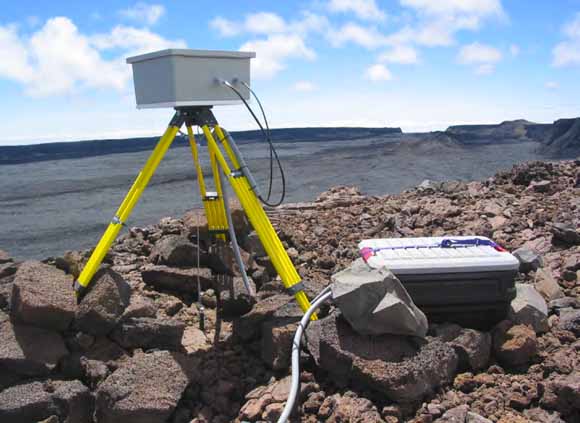
Camera enclosure and mounting tripod on the rim of Moku‘āweweo caldera near the summit of Mauna Loa. The power and Ethernet connectors have been waterproofed with silicone sealant (from figure 7).
Lists of important volcano-monitoring disciplines usually include seismology, geodesy, and gas geochemistry. Visual monitoring—the essence of volcanology—is usually not mentioned. Yet, observations of the outward appearance of a volcano provide data that is equally as important as that provided by the other disciplines.
The eye was almost certainly the first volcano monitoring-tool used by early man. Early volcanology was mostly descriptive and was based on careful visual observations of volcanoes. There is still no substitute for the eye of an experienced volcanologist. Today, scientific instruments replace or augment our senses as monitoring tools because instruments are faster and more sensitive, work tirelessly day and night, keep better records, operate in hazardous environments, do not generate lawsuits when damaged or destroyed, and in most cases are cheaper. Furthermore, instruments are capable of detecting phenomena that are outside the reach of our senses. The human eye is now augmented by the camera. Sequences of timed images provide a record of visual phenomena that occur on and above the surface of volcanoes. Photographic monitoring is a fundamental monitoring tool; image sequences can often provide the basis for interpreting other data streams.
Monitoring data are most useful when they are generated and are available for analysis in real-time or near real-time. This report describes the current (as of 2006) system for real-time photograph acquisition and transmission from remote sites on Kīlauea and Mauna Loa volcanoes to the U.S. Geological Survey Hawaiian Volcano Observatory (HVO). It also describes how the photographs are archived and analyzed. In addition to providing system documentation for HVO, we hope that the report will prove useful as a practical guide to the construction of a high-bandwidth network for the telemetry of real-time data from remote locations.
A companion paper (Orr and Hoblitt, 2008) describes non-telemetered time-lapse camera systems used by the Hawaiian Volcano Observatory on Kīlauea volcano.
Download this report as a 22-page PDF file (sir2008-5129.pdf; 1.4 MB)
For questions about this report, contact Richard Hoblitt.
Suggested citation and version history
| Help | Publications main page | Western Scientific Investigations Reports |
| Geology | Volcano Hazards Program |
This report is available only on the Web

![]() U.S. Department of the Interior | U.S. Geological Survey
U.S. Department of the Interior | U.S. Geological Survey
URL: http://pubs.usgs.gov/of/2008/5129/
Page Contact Information: Michael Diggles
Page Created: September 4, 2008
Page Last Modified: September 4, 2008
(mfd)