Scientific Investigations Report 2008-5158
1 U.S. Geological Survey
2 Massachusetts Department of Conservation and Recreation
ABSTRACT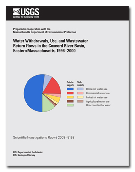
Water withdrawals, use, and wastewater return flows for the Concord River Basin were estimated for the period 1996–2000. The study area in eastern Massachusetts is 400 square miles in area and includes the basins of two major tributaries, the Assabet and Sudbury Rivers, along with the Concord River, which starts at the confluence of the two tributaries. About 400,000 people lived in the basin during the study period, on the basis of an analysis of census data, land use, and population density. Public water systems served an estimated 87 percent of the people in the basin, and public wastewater systems served an estimated 65 percent of the basin population. The estimates of water withdrawals, use, wastewater return flows, and imports and exports for the Concord River Basin and 25 subbasins provide information that can be used in hydrologic analyses such as water budgets and can guide water-resources allocations for human and environmental needs. Withdrawals in the basin were estimated at 12,700 million gallons per year (Mgal/yr) during the study period, of which 10,100 Mgal/yr (about 80 percent) were withdrawn by public water-supply systems and 2,650 Mgal/yr were self-supplied by individual users. Water use in the basin and subbasins was estimated by using water withdrawals, average per capita use rates (about 72 gallons per day per person), land-use data, estimated population densities, and other information. Total water use in the basin, which included imports, was 19,200 Mgal/yr and was provided mostly (86.2 percent) by public supply. Domestic use (11,300 Mgal/yr) was the largest component, accounting for about 60 percent of total water use in the basin. Commercial use (3,770 Mgal/yr), industrial use (1,330 Mgal/yr), and agricultural use (including golf-course irrigation; 562 Mgal/yr) accounted for 19.6, 6.9, and 2.9 percent, respectively, of total use. Water that was unaccounted for in public-supply systems was estimated at 2,260 Mgal/yr, or 11.8 percent of total water use in the basin. Wastewater return flows discharged in the basin were estimated at 11,800 Mgal/yr, of which 6,620 Mgal/yr were discharged from municipal wastewater-treatment facilities to surface waters and 5,190 Mgal/yr were self-disposed through septic systems to ground water; wastewater disposed through septic systems was generated by both public- and self-supply use. Water use and management in the Concord River Basin resulted in an estimated import of 6,460 Mgal/yr of potable water for public supply and an estimated export of 6,590 Mgal/yr of wastewater. Water was imported into the Assabet, Sudbury, and Lower Concord (the area draining directly to the Concord River) River Basins for public supply. Wastewater was imported into the Assabet River Basin, but exported from the Sudbury and Lower Concord River Basins. Of the 25 subbasins in the Concord River Basin for which water use was analyzed, 20 subbasins imported potable water, 4 subbasins exported potable water (Fort Meadow Brook, Indian Brook, Lower Sudbury River, and Whitehall Brook), and potable water was neither imported nor exported in one subbasin (Elizabeth Brook). Wastewater was imported into the Assabet Headwaters, Assabet Main Stem, and Hop Brook subbasins; wastewater was neither imported to nor exported from the Elizabeth Brook, Nashoba Brook, and Pine Brook subbasins; and wastewater was exported from all other subbasins. Water use and management in the basin also resulted in a net transfer of water from ground water to surface water, discharged as wastewater, of about 4,000 Mgal/yr. |
For additional information contact: Part or all of this report is presented in Portable Document Format (PDF); the latest version of Adobe Reader or similar software is required to view it. Download the latest version of Adobe Reader, free of charge. |
Barlow, L.K., Hutchins, L.M., and DeSimone, L.A., 2009, Water withdrawals, use, and wastewater return flows in the Concord River Basin, eastern Massachusetts, 1996–2000: U.S. Geological Survey Scientific Investigations Report 2008–5158, 123 p.
Abstract
Introduction
Purpose and Scope
Previous Investigations
Description of the Study Area
Water-Use Terms
Population Estimates for Water Withdrawals, Use, and Wastewater Return Flows
Water Withdrawals and Use
Water Withdrawals
Water Use
Domestic
Public Supply
Self-Supply
Commercial
Public Supply
Self-Supply
Industrial
Public Supply
Self-Supply
Agricultural
Public Supply
Self-Supply
Unaccounted-For
Consumptive
Summary of Water Use and Withdrawals
Water Imports and Exports for Public Supply
Wastewater Return Flows
Wastewater Discharges from Treatment Facilities
Wastewater Return Flows from Self-Disposal
Wastewater Imports and Exports
Summary of Water Withdrawals, Use, and Wastewater Return Flows
Data and Analysis Limitations
Withdrawal Data
Wastewater Return-Flow Data
Commercial and Industrial Water-Use Data
Analysis Methods
Summary
Acknowledgments
References Cited
Appendix 1. Monthly average withdrawals for community public-supply sources by subbasin and year in the Concord River Basin in eastern Massachusetts, 1996–2000
Appendix 2. Monthly average purchases from the Massachusetts Water Resources Authority by municipal community public-supply systems in the Concord River Basin in eastern Massachusetts, 1996–2000
Appendix 3. Monthly average withdrawals regulated by the Massachusetts Water Management Act for commercial, industrial, and agricultural users in the Concord River Basin in eastern Massachusetts, 1996–2000

![]() U.S. Department of the Interior |
U.S. Geological Survey
U.S. Department of the Interior |
U.S. Geological Survey
[an error occurred while processing this directive]
URL: http://pubsdata.usgs.gov
Page Contact Information: Contact USGS
Page Last Modified: Thursday, 10-Jan-2013 19:03:23 EST
