Scientific Investigations Report 2009–5078
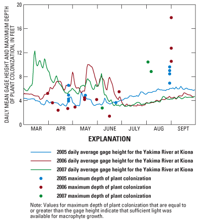
Figure 25. Daily mean gage height and maximum depths of plant colonization estimated at RM 30 and RM 20, Yakima River, Washington March 1–September 30, 2005–07. |
For additional information contact: Part or all of this report is presented in Portable Document Format (PDF); the latest version of Adobe Reader or similar software is required to view it. Download the latest version of Adobe Reader, free of charge. |

![]() U.S. Department of the Interior | U.S. Geological Survey
U.S. Department of the Interior | U.S. Geological Survey
URL: http://
pubsdata.usgs.gov
/pubs/sir/2009/5078/figure25.html
Page Contact Information: Contact USGS
Page Last Modified:
Thursday, 10-Jan-2013 19:30:19 EST
