Scientific Investigations Report 2009-5184
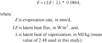
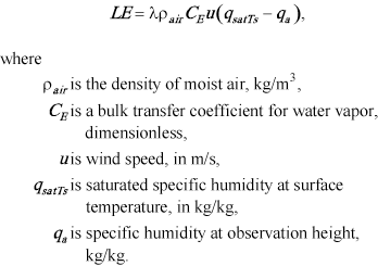
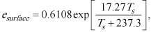
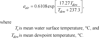
Data Used in This StudyComponents of the water-budget include surface-water inflow and outflow, precipitation and evaporation, changes in lake storage, and estimates of consumptive use for withdrawals from the lake for domestic and municipal uses and from wells near the lakeshore. Referenced values of streamflow losses to the SVRP aquifer from the Spokane River between the outlet of Coeur d’Alene Lake and Post Falls Dam, seepage from Coeur d’Alene Lake to the SVRP aquifer, and a residual value also are considered in the budget and explained in this section. Surface-water inflow was calculated using six USGS stream-gaging stations (S1, S2, S3, S4, S5, S6) on tributaries to Coeur d’Alene Lake. Surface-water outflow was computed using one stream-gaging station (S10) on the Spokane River about 11 mi downstream of the lake outlet (fig. 1). Precipitation to the lake was calculated using data collected from three National Weather Service (NWS) weather stations (CDA, P3, SM) on the perimeter of the lake. Evaporation was calculated using wind speed, air temperature, and dew point data collected from the weather stations, and water temperature and wind speed data collected from six USGS pelagic stations (L1, L2, L3, L4, L5, and L6) on the lake (fig. 1, table 2). These data were combined to estimate evaporation from deep water bodies using methods described by Allen and Robison (2007). Changes in lake storage were calculated using mean monthly stage at the USGS lake station (L7) on Coeur d’Alene Lake. Withdrawals from the lake were estimated using reported withdrawals from purveyors if available, or otherwise from water rights data and domestic water-use coefficients. Consumptive use was estimated as a percentage of the total withdrawals. InflowsSurface-water inflows to Coeur d’Alene Lake were calculated using several methods and data sources because continuous, measured data were not available for all tributaries for water years 2000–2005. All measured data are compliant with USGS data collection techniques and standard protocol (Rantz and others, 1982). Ungaged tributary inflows were calculated using the balance of the drainage area of the basin and average yield calculated from four (S3, S4, S5, S6) of the six gaged tributaries. Inflows from the two largest drainage basins were calculated using data from USGS stream-gaging stations at Coeur d’Alene River near Harrison (S1) and St. Joe River near Chatcolet (S2) (table 3). Flows at the Coeur d’Alene River near Harrison stream-gaging station for water years 2000–2003 and part of water year 2004 (October 2003–February 2004) were derived from the FOURPT model of the Coeur d’Alene River (Beckwith and others, 1997). Flows for the remainder of water year 2004 (March 2004–September 2004) and for water year 2005 were measured using an acoustic Doppler velocity meter and stage sensor installed at the site. Flows at the St. Joe River near Chatcolet stream-gaging station were available only for March of water year 2004 through water year 2005. Unavailable flow data (water year 2000 to February 2004) for the Chatcolet steam-gaging station were extrapolated using flows from the St. Maries River near Santa stream-gaging station (S9) and a flow ratio value that was calculated using existing data for the two sites when flows were measured at both sites. The St. Maries near Santa stream-gaging station provided the most complete record for filling in unavailable data for the St. Joe River near Chatcolet stream-gaging station because no flows were measured during water years 2000–2005 at the St. Joe River at St. Maries stream-gaging station (S11), which is the next site upstream from the Chatcolet stream-gaging station. Additionally, an analysis of the combined flows for the St. Joe River at Calder stream-gaging station (S10), and the St. Maries near Santa stream-gaging station, plus effluent to the St. Joe River from the St. Maries wastewater treatment facility located in St. Maries, were suspect and therefore unusable because they were less than the annual flows on the Coeur d’Alene River near Harrison stream-gaging station. Historically, flows into Coeur d’Alene Lake from the St. Joe River are substantially greater than those from the Coeur d’Alene River, as seen in records from water year 2004 (March) to present. Data from USGS stream-gaging stations on four smaller tributaries were used in the water budget (table 3); they included Wolf Lodge Creek near Coeur d’Alene (S6), Plummer Creek near Plummer, (S3), Fighting Creek near Rockford Bay (S4), Carlin Creek near Harrison (S5). None of these sites were measured during water years 2000–2005, but they were measured during water years 1991–94. Flows were estimated using flow ratios from the St. Maries River near Santa, and the Coeur d’Alene River near Cataldo stream-gaging stations (S8). Plummer Creek and Fighting Creek data were used with the data from St. Maries River near Santa stream-gaging station. The data for Wolf Lodge Creek near Coeur d’Alene and the Carlin Creek near Harrison stream-gaging stations were used with the Coeur d’Alene River near Cataldo station. A flow ratio was calculated using water years 1991–1992 data and then this flow ratio was used to extrapolate the unavailable flow data for water years 2000–2005. Inflows for ungaged tributary basins surrounding the lake were calculated using a mean runoff value based on yields from the four smaller tributaries (Plummer, Fighting, Carlin, and Wolf Lodge Creeks), and the residual ungaged tributary area (447 mi2). OutflowsOutflows from Coeur d’Alene Lake were calculated using data collected from the USGS stream-gaging stations on the Spokane River near Post Falls, Idaho (S7). The gage is at the Post Falls Dam, about 11 mi downstream of the outlet of the Coeur d’Alene Lake, and is used to regulate streamflow in the Spokane River and water levels at Coeur d’Alene Lake. Between December and June, flows in the Spokane River are not restricted at the dam, so generally the outflow at Post Falls Dam is the direct result of inflow (snowmelt, runoff, and precipitation) to the lake. During summer, the dam is used to regulate flows in the Spokane River and to maintain water levels on Coeur d’Alene Lake for recreation (Hortness and Covert, 2005). Mean monthly and mean annual flows at the Spokane River stream-gaging station were calculated using data from water years 2000 to 2005. Additional data were collected to adjust the flow data for the Spokane River at Post Falls Dam stream-gaging station. The wastewater treatment facility for the city of Coeur d’Alene discharges effluent to the Spokane River near the outlet of the lake. The city of Coeur d’Alene uses groundwater that is pumped from the SVRP aquifer system for public supply, domestic and other uses. Discharges from the wastewater treatment facility are essentially groundwater from the SVRP aquifer that is released to the Spokane River. Wastewater treatment facility discharges were compiled for water years 2000–2005, and subtracted from the mean annual flow at the Spokane River stream-gaging station to adjust for the additional flows to the river that were not associated with the lake (table 3). Similarly, seepage studies on the Spokane River between the outlet and Post Falls Dam indicated that, at least during summer (August), the aquifer gained 291 ft3/s of water from the Spokane River (Hsieh and others, 2007, p. 29). But these data only account for the seepage loss from Spokane River and not losses from Coeur d’Alene Lake. Wyman (1993) estimated that 230 ft3/s of water was lost from Coeur d’Alene Lake and the Spokane River to the SVRP aquifer; therefore, the annual volume of water equivalent to 230 ft3/s (7,250 million ft3,or 167 thousand acre-ft) was used in the budget, however it appears low compared to more recent data by Hsieh and others (2007). More analysis and data collection is needed to more accurately determine the amount of water that the SVRP aquifer gains from Coeur d’Alene Lake and the Spokane River. Precipitation and EvaporationMean monthly precipitation, wind speed, dew point, and air-temperature data from three National Weather Service stations, and miscellaneous water temperature data from six USGS pelagic monitoring sites were used to calculate the precipitation (positive flux) and evaporation (negative flux) components of the water budget for the lake. The lake is triangulated by three weather stations, Coeur d’Alene 1E (CDA), Plummer 3 WSW (P3), and St. Maries (SM), from which atmospheric data were collected for this study (fig. 1). The Coeur d’Alene station is at the Coeur d’Alene Airport, the Plummer station about 8 mi southwest of the southern edge of the lake near Plummer, Idaho, and the St. Maries station is about 5 mi southeast of the southern tip of the lake in St. Maries, Idaho. Monthly precipitation was calculated using mean monthly precipitation based on the period of record for all three stations (table 4). Annual precipitation was calculated for each year of the water budget using the monthly values of precipitation for that year and the surface area of the lake (50 mi2). Mean monthly evaporation from the water surface of Coeur d’Alene Lake was calculated using mean monthly air temperature, wind speed, and dew point data from the weather stations and mean monthly water temperature and wind speed data from six USGS pelagic monitoring sites. The data were calculated using methodology described by Allen and Robison (2007) for deep water bodies. This methodology, further explained by Allen and Tasumi (2005), estimates evaporation using the aerodynamic approach and Bowen ratio energy balance gradients derived by the following equations:
Latent heat flux is derived as:
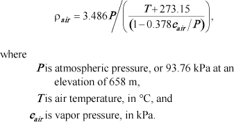
The bulk transfer coefficient for water vapor (CE), was estimated as 0.0015 (Richard G. Allen, University of Idaho, written commun., 2007). Latent heat flux was calculated using the mean monthly air temperatures, wind speeds, dew points, and water-surface temperatures shown in table 4. Density of moist air in equation 3 is calculated as:
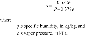
Specific humidity, (q in equation 3), is calculated using vapor pressure (e) from Allen and Robison (2007):
The vapor pressure at water surface was calculated as saturation pressure at water surface temperature. Air vapor pressure, eair, is the air vapor pressure used in equation 4 to calculate qa. The functions used from Allen and Robison (2007) for vapor pressure were:
Mean monthly air temperature and precipitation data collected from all three weather stations between 1996 and 2006 were used to calculate mean monthly and annual values of evaporation. The Plummer 3 WSW (P3) and the St. Maries (SM) stations lacked dew point and wind speed data; therefore, dew point and wind speed data for the same period were used from Coeur d’Alene 1E (CDA) station. Unavailable temperature data were replaced with the mean monthly values from the 30-year period from 1971 to 2000. Additionally, water temperature and wind speed data were collected intermittently at the USGS pelagic monitoring sites between 1989 and 2006, mostly between April and July (Deb Parliman and Molly Wood, U.S. Geological Survey, written commun., 2007). Water temperatures collected at 1-m depths were used to compute mean monthly water temperatures. Insufficient data were available during September; therefore, the average of August and October was used to calculate the September mean monthly water temperature. Mean monthly water temperatures ranged from a minimum of 1.6°C in March to a maximum of 17.3°C in August (table 4). Lake Storage and WithdrawalsThe USGS station (Coeur d’Alene Lake at Coeur d’Alene, L7) is just southwest of the city of Coeur d’Alene. In operation since 1903, this station provides the lake stage data that is converted to storage in the lake above the 2,120 ft elevation. This study used the same capacity conversion table that is currently used to report the storage in the annual Idaho water data reports (http://wdr.water.usgs.gov/) (Tom Brennan, U.S. Geological Survey, written commun., 2007). Changes in storage were calculated using the mean monthly storage during the study period, and summarized to annual net changes for each water year (table 5). No data were available for January 2004; therefore, the unavailable value was replaced with the mean monthly January value. Releases from Coeur d’Alene Lake are regulated at Post Falls Dam and, during summer, flows are maintained to accommodate sufficient lake levels when recreational use of the lake is at its annual peak. Using mean monthly changes in storage for the period of record, the greatest monthly gains in storage occurred between March and April when spring runoff occurs, with an average net gain of more than 2,000 million ft3 (49,700 acre-ft). The largest average monthly loss from storage was between September and October, with an average net loss of almost 1,800 million ft3 (41,000 acre-ft). Coeur d’Alene Lake is a source of water for domestic uses, including fire protection, landscape irrigation, some livestock, and aesthetics. The lake also serves municipal and other irrigation (golf course), commercial, and industrial uses. Twenty small municipal or homeowner associations hold water rights for surface water from Coeur d’Alene Lake (Idaho Department of Water Resources, written commun., 2007). The city of Coeur d’Alene holds a surface-water right but did not use any water from Coeur d’Alene Lake during water years 2000-2005 (Jim Markley, Coeur d’Alene City Water Department, Superintendent, verbal communication, 2008). The IDWR water rights database contains over 320 water-rights for Coeur d’Alene Lake water, and most of those rights are filed by individual homeowners and allocated for domestic uses, for which no measured data exist. Water rights data were used to estimate monthly withdrawals if reported data were lacking; few of the municipal or homeowner associations measure withdrawals. However, three associations reported annual data that were used in this study: Harbor View Estates, Black Rock, and Cottowood Point. Using the water-rights database and assuming that all the homeowners used their full allocation of water during the year, a mean annual withdrawal from Coeur d’Alene Lake was estimated at about 1,270 million ft3 (29,100 acre-ft) (table 6). However, not all withdrawals are consumptively used; in fact, only a small part of the withdrawals are lost to evapotranspiration or exported from the basin. Most withdrawals are returned to the lake through groundwater recharge from irrigation, runoff, or septic system infiltration. A consumptive-use coefficient of 15 percent (Shaffer, 2008) was used to estimate that part of total withdrawals that was consumptively lost, resulting in an estimated net loss from Coeur d’Alene Lake of about 190 million ft3 annually (4,368 acre-ft). Another approach to estimating withdrawals for all domestic water uses is to use per capita use rates based on a 2005 USGS survey of cities in Kootenai County. The survey queried Coeur d’Alene and St. Maries water supply facilities for total public-supply withdrawals and customer information. A per capita use rate of 330 gallons per capita per day (GPCD) was calculated for the city of Coeur d’Alene. The GPCD rate for Coeur d’Alene was used to estimate withdrawals for all domestic records with a surface-water right from Coeur d’Alene Lake, assuming that a single record will serve one household and that an average of 2.6 persons occupy each household. About 300 households had water rights from the lake, which resulted in a total annual estimate for domestic withdrawals of 12.6 million ft3 (290 acre-ft). The per capita use rate estimate is clearly much less than the water-right estimate; therefore, to avoid potentially underestimating withdrawals, consumptive use was calculated on the withdrawals based on the water-right estimate and used in the annual water budgets. Groundwater withdrawals for domestic wells within a 1,000 ft buffer around Coeur d’Alene Lake were assessed using IDWR water-rights file records and the 330 GPCD use rate. A conservative count of 520 wells was established by eliminating duplicate records from analysis. The actual number of wells surrounding the lake may be greater. An annual groundwater withdrawal estimate of 21.8 million ft3 (500 acre-ft) was calculated from groundwater sources within 1,000 ft of the shoreline. Using the 15 percent consumptive-use coefficient, the total annual net loss from nearshore groundwater withdrawals was estimated at 3.2 million ft3 (75 acre-ft). The annual net loss from estimated groundwater withdrawals was combined with the estimated net loss from surface-water withdrawals for a total consumptive use of 265 million ft3 (6,097 acre-ft). |
For additional information contact: Director, Idaho Water Science Center Part or all of this report is presented in Portable Document Format (PDF); the latest version of Adobe Reader or similar software is required to view it. Download the latest version of Adobe Reader, free of charge. |

![]() U.S. Department of the Interior | U.S. Geological Survey
U.S. Department of the Interior | U.S. Geological Survey
URL: http://
pubsdata.usgs.gov
/pubs/sir/2009/5184/section4.html
Page Contact Information: Contact USGS
Page Last Modified:
Thursday, 10-Jan-2013 19:36:12 EST

 (2)
(2) (3)
(3) (4)
(4) (5)
(5) (6)
(6) (7)
(7)