Skip Links

USGS - science for a changing world

Scientific Investigations Report 2010–5016
Development of an Environmental Flow Framework for the McKenzie River Basin, Oregon

Figure - refer to figure caption for alternative text description

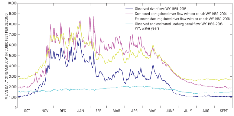
Figure 16. Mean daily streamflow in Reach 8 at McKenzie River below Leaburg Dam, near Leaburg, Oregon (14163150) and Leaburg Canal.

First posted February 8, 2010

For additional information contact:
Director, Oregon Water Science Center
U.S. Geological Survey
2130 SW 5th Avenue
Portland, Oregon 97201
http://or.water.usgs.gov

Part or all of this report is presented in Portable Document Format (PDF); the latest version of Adobe Reader or similar software is required to view it. Download the latest version of Adobe Reader, free of charge.

Accessibility FOIA Privacy Policies and Notices

Take Pride in America logo USA.gov logo U.S. Department of the Interior | U.S. Geological Survey
URL: http:// pubsdata.usgs.gov /pubs/sir/2010/5016/figure16.html
Page Contact Information: Contact USGS
Page Last Modified: Thursday, 10-Jan-2013 19:07:29 EST